Discover the Davenport Ranges

THIS SECRET IS almost too good to share. It’s a little-known national park in the middle of the Northern Territory, where you can camp right next to some of Australia’s best inland waterholes.
Around the inviting water, the red rocks, startling white ghost gums and spinifex remind you that you are in the heart of the outback, while the air hums with birdsong. You can pause to soak in the serenity, before driving across ragged ranges on a dedicated four-wheel-drive track, where you’re unlikely to see another soul.
Just a couple of hours drive off the Stuart Highway, between Alice Springs and Tennant Creek, Iytwelepenty – or the Davenport Ranges National Park – is one of the little-known jewels of Central Australia. In almost 20 years of writing for Australian Geographic, I don’t think I’ve ever come across a place like it in the middle of the country – a place so little travelled, but relatively easily reached, where the inland breathes life back into you.
This isn’t a developed national park with a list of walking tracks to cross off; currently there are almost none, and there are only a couple of places you are encouraged to explore. Instead, more than any other park I’ve visited, this is a place to slow down, to spend time just sitting by, or in, a waterhole as you absorb the daily changes, soaking in peace as the country morphs from its vibrant crepuscular colours to bleached straw and salmon during the heat of the day. It’s a birdwatcher’s delight, and in one afternoon I cross five more species off my birdwatching checklist, including painted finches, one of the most spectacular small birds I’ve seen.

Rainbow bee-eater (Merops ornatus). These bright birds are Australia’s only species of bee-eater. During the breeding season, instead of nesting in trees, bee-eaters dig a tunnel on the banks of a river or creek, where they lay their eggs. (Image: Heath Holden)
There are few facilities, it’s remote and you’ll need a sense of adventure and a 4WD to get there, but don’t let that stop you – this is one place you want to find.
SLAP BANG DOWN the middle of the Territory, the black tar of the Stuart Highway carves it into east and west. In the centre, just north of Karlu Karlu (the Devils Marbles), a sign indicates a 50km drive along a well-graded dirt road to Kurundi station, then there’s another 18km of winding gravel and sand to the turn-off to the 1120sq.km national park. From the moment photographer Heath Holden and I swing our 4WD south towards Whistleduck Creek, the birdlife increases significantly, almost as if a switch is flicked. We see more birds in 20km than we’ve seen in days spent elsewhere in Central Australia. There are black-faced cuckoo shrikes, rainbow bee-eaters, spinifex pigeons, diamond and peaceful doves, a flock of budgies and myriad honeyeaters.
In a parched land, where the dust coats the inside of your mouth and your lungs, birds flock here because the park offers hidden pockets of waterholes. The Davenport Range also attracts a wide variety of animals because there is such an eclectic mix of vegetation – it’s the crossover between the plants of the central desert and more tropical species such as the silver-leafed grevillea, with rainfall here averaging 400mm a year. It has hints of the Tanami, the arid country further south, and a serene oasis around the water.
Through rolling hills dressed in snappy gum and soft spinifex, occasional coolibahs, curry wattles and thick mulga, we wind our way down to Whistleduck Creek camping ground, finding it adorned with a profusion of Sturt’s desert rose – the floral emblem of the Territory. The simple, spread-out camping ground has a couple of pit toilets, benches and fireplaces, and a few shady trees. It’s set back about 1km from the first major waterhole, Irrmweng Rockhole. At this delightful permanent puddle, where a hot wind blows leaves off the gums and the red rocks radiate heat like a pizza oven, a graceful little black cormorant watches swimming ducks and black-fronted dotterels that scamper along the wet sand.
Hidden in the foliage of a large gum, a collared sparrowhawk lurks, its beady yellow eyes on the lookout for slow-moving prey.
The water is a sanctuary from the heat, approaching 40°C, but thankfully we don’t stop for too long, because something better is in store. Just a few hundred metres upstream is the divine Injaidan Rockhole. About the size of an Olympic pool and almost as deep, but with a base of stones polished by time, it has 25m-high red rock walls, with ghost gums and snappy gums growing out of them. In the water, spangled perch – some the size of a shoe – flash silver sides, and in the shallows linger plenty of the other six species of smaller fish, including striped grunters, purple-spotted gudgeon and desert rainbowfish. Resplendent rainbow bee-eaters zip around as they swoop to catch giant golden wasps and small red dragonflies, flicking enamel-sheen wings in flight like a Chinese fan dance. Way overhead, two wedge-tailed eagles patrol, one a lighter juvenile, and the other a wizened old black bird that has seen a few summers.
The water’s edge offers a cool respite and refreshment for a steady stream of species: zebra finches; grey-headed honeyeaters; and native canaries, or white-plumed honeyeaters, with delicate brushes of white across their necks. And then, my top sighting of the trip, a party of painted finches comes down to drink, their black chests spotted with white like a dot painting. A male shows off his red beak and superhero-style blaze across his chest.
Just back from the waterhole are spinifex pigeons, the straw tuft on their heads imitating the spiky grass. A variety of dragons come to quench their thirst, including the long-nosed dragon, which stands on three legs and waves, as if welcoming strangers to its special spot. And up hidden in the clefts of the rocks around here are the most northerly population of black-footed rock- wallabies. At sunset, a mob of cattle also come to drink. They shouldn’t be here, and their destructive pads spoil this special spot. But they, too, are part of the area’s history.
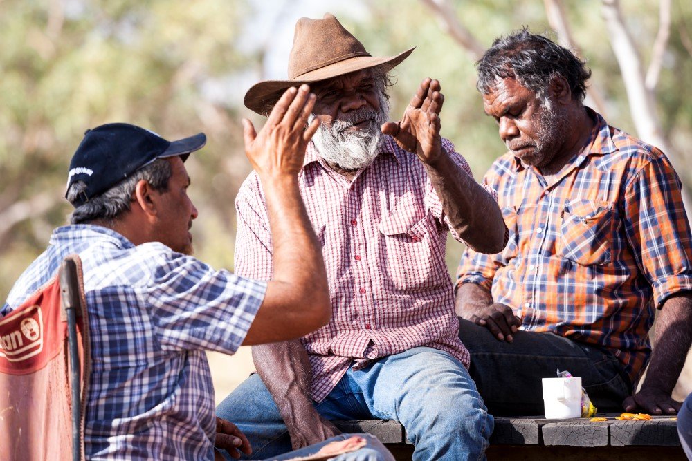
Traditional owner and senior lawman John Duggie (below, at centre) chats with Michael Liddle (at left) and Phillip Peterson. John lives near Tennant Creek and visits the park several times a year for meetings, and to help with burning and other projects. (Image: Heath Holden)
“THERE ARE WATERHOLES all through this country – you’ll never perish out here,” says quietly spoken Michael Liddle, intercultural engagement manager at Desert Knowledge Australia. Michael is an Alyawarre man, and one of the traditional owners of Iytwelepenty. The area involves the Alyawarre, Kaytetye, Wakaya and Warumungu groups and they are still engaged with the park today.
Jointly managed by traditional owners and the NT Parks and Wildlife Commission, the park is filled with sacred sites, artworks and secret, special places still used for ceremonies. As we drive through it, Michael is careful not to reveal too much. “We don’t want to show the tourists,” he says. “It belongs to us, and we’ve got to keep looking after it.”
At times, conversing privately in their own language, Michael, his father-and-senior-lawman John Duggie, and his brother- in-law Phillip Peterson carefully discuss what they can tell outsiders. It’s a constant struggle to manage the park in a modern world, while maintaining an ancient culture and traditions where key information is restricted to a few people. For example, the men will share some sites and information with the non-indigenous rangers, to help with fire and other park management issues, but they will only discuss men’s sites.
There is plenty in these rich, ancient desert cultures that can be revealed. The ancient people used to travel through this country – often at night – in large family groups, “big mobs, more than 50”, John says. During the hottest time of the year, they would stop by a big waterhole for up to six months, heading out for one-day hunting trips, and living in more permanent humpy shelters insulated with spinifex.
“Hard work, but it makes it cooler,” Michael says. They’d make coolamons – dishes to carry water – out of bean trees and spears out of the soapbush tree. “When making spears and preparing the flint to sit on the spear it was important not to eat, otherwise the spear would end up round, like your guts after a meal, and would not have the polish of a lean knife,” Michael says. “You’ve got to go hungry to make a spear, so it’s mean and hungry and sharp.”
Food was plentiful, with soapbush wattle seeds ground up for damper, yams dug up along the riverbed, bush tomatoes, bush coconuts and bush oranges, as well as fish, echidnas, goannas and the occasional emu, or black-tailed wallaby brought down with a boomerang across the legs and finished off with a spear. But the absolute favourite – then and now – was ingkwarl. The name now often refers to ‘something sweet’ but traditionally it means ‘sugarbag’ – native honey. “It’s the most beautiful food,” Michael says.
Unlike some groups to the north-east who were known to be more ferocious in their customs, the indigenous people here were considered relatively peace-loving, preferring to take part in tyenkerr – giving and receiving gifts such as hair belts, boomerangs and sugarbag – rather than fight with spears. But when the pastoralists moved in in the late 19th century, conflict was almost inevitable.
“When the Aboriginal people first seen the cattle in the country they killed it and they couldn’t believe how much fat was in it, and they thought, ‘Oh, we like this’,” Michael says. “Fat played a really important role; it was used for healing, for medicinal purposes, and for warmth and for ceremony.”
“They rub it on their skin, they put it in their hair,” John adds.

A couple of hours drive off the Stuart Highway, between Alice Springs and Tennant Creek, Iytwelepenty is one of the little-known jewels of Central Australia. (Image: Heath Holden)
The area around Whistleduck Creek is known as special ‘rainmaker’ country – an important place for ceremonies to direct the weather. “They used to tell old fella living in this country he was rainmaker,” John says. “A lot of people used to come down from other places and say ‘we have not much water’, and tell that old rainmaker, ‘we have not much rain’. Then they start ceremony for the rain to come.” This special men’s ceremony would involve the clapping of boomerangs and dancing.
Michael says that the park is still used for ancient business. Sacred objects are passed down to the keepers of particular aspects of the landscape, such as plants or animals, initiation ceremonies are still taking place to welcome men and women into adulthood, and songs and dances are performed to keep the land flourishing. He laments the fact that ceremonies aren’t undertaken as regularly as they once were. “People used to sit down and talk about meat and fruits, and the need to replenish the country, but there’s no need to do that anymore. The need to sing for that sort of sustainability has been replaced by buying food from the store.”
John, 62, was born just outside what is now the park boundary, and grew up at Kurinelli, an outstation for Kurundi. He learnt the ancient laws from his father, the chief lawman. He has watched a lot of changes occur over his country, such as the decline of emu numbers and the demise of the Central Australian brush-tailed possum. “They used to be all around this area, big mobs, but they all gone.” None of the men know why, although the introduction of cattle, cats and big bushfires are suggested as likely culprits.
John comes out to the park, from his home near Tennant Creek, several times a year for meetings and to help with burning and other projects. He says seeing the cattle damage at Irrmweng Rockhole makes him sad. “Our water just go down quick. In old days the water used to last until the next rains come.”
Later we travel to the old Kurinelli homestead that once provided rations to John and his family and others at the outstation. There’s nothing left but some concrete slabs and old bottles. Nearby stands abandoned mining equipment from the 1940s, where the corpse of a dingo pup lies curled inside an old drum.
THE BIGGEST AND MOST impressive waterhole is the Old Police Station Waterhole, which the Alyawarre call Thethew. The area carries a dark history. When drovers first arrived at the plains beside the Frew River with mobs of cattle in the early 1890s, they drove the indigenous people away from waterholes that had sustained them for many thousands of years.
Watch a short video about Iytwelepenty-Davenport Ranges National Park.
“They didn’t want Aboriginals drinking the water, because that was for them and their cattle,” Michael says. Tensions rose, the manager of nearby Elkedra station was speared, hit with a boomerang and a tomahawk, and the reprisals on both sides were fierce until Elkedra and Frew River cattle stations were abandoned in 1896.
White settlement returned with the outbreak of World War I, in order to mine tungsten for armaments. To keep the peace and patrol mining areas, a policeman was posted for a few years. As a result of the added security, the pastoralists soon returned. The crumbled remains of the policeman’s cottage, and the Frew River station homestead, now lie on one bank of the splendid, deep waterhole.
After taking a long, refreshing swim accompanied by the lovely song of a whistling kite, I walk around this glorious blue jewel in about an hour. Three pelicans float in one corner of the waterhole. Although it doesn’t have the bird diversity of the smaller waterholes, it makes up for it in numbers, with large flocks of screaming corellas, and quieter groups of little black cormorants.
The campsites here stretch right along one side of the waterhole, with a night in the swag disturbed only by the braying of feral donkeys on the flats on the other side. We see plenty more on the drive out the next day. “There are large numbers outside the park,” says Tim Leane, senior park ranger in the Barkly District. “They have a high toll in erosion.” He says the cattle in the park are a more tricky issue, and often are a result of fences coming down after heavy rains or animals wandering into the unfenced south-west. Parks and Wildlife are in ongoing negotiations with the neighbouring landholders to remove both branded and cleanskin cattle. “There’s probably a few hundred across the park,” he says.
Once part of Kurundi station, the rangelands here were hard to muster cattle on, so the land was sold to national parks in the 1990s. “It was partly to have a better park for the Barkly and Tennant Creek community, but also because the Davenport-Murchison Ranges bioregion is entirely encompassed in the NT, and we needed to protect it,” Tim says. For a few years it was known as a ‘proposed’ national park, and then in 2008 it became Aboriginal freehold land, and leased back to the NT government. It wasn’t officially named Iytwelepenty/Davenport Ranges National Park until 2011.
As a final way to experience the park, before tackling the deeper bulldust on the southern road out, we take the wonderful 17km Frew River 4WD loop track over the top of the ranges. The drive takes almost two hours because it’s pretty bumpy, but is worth it. It starts from the Old Police Station Waterhole with a short 15-minute hop to the Frew River campsites, where there are no pit toilets, but some tables and fireplaces, and a very quiet billabong.
Then the well-defined track heads up and over rocky hills, and I need to shift down to first gear in a couple of spots. It’s a fun, very achievable little adventure, as long as you’re in a high-clearance 4WD. There are glorious views over the range country. We can see the green line of distant river red gums along the Frew like a necklace joining together those sparkling waterhole jewels where we had bathed and basked in beauty. Beyond, the spinifex lines the country as it stretches to a hazy horizon.
READ MORE:
- VIDEO: The Territory’s best-kept secret
- Red dust, gold heart: Tennant Creek, NT
- Chasing waterfalls in Tropical North Queensland


