Heading for the hills in Tropical North Queensland

I WAS GOBSMACKED. A massive Queensland groper lazily swam over to my sea kayak before performing the aquatic equivalent of ‘buzzing the tower’, swimming directly beneath my watercraft. It was an exciting moment…well, for me, anyway. The huge fish – at least 2.5m long – looked anything but excited as it lazily swung its head up to give me a casual glance before it rolled back over and, with a powerful flick of its tail, disappeared into deeper water.
If there’s a better way to start a road trip, I haven’t yet experienced it. Tropical North Queensland had really turned it on. The close encounter topped off what had already been an enjoyable paddle. Photographer Mark Watson and I had dragged ourselves out of bed for a pre-dawn start with Coral Sea Kayaks’ David Tofler and Atalanta ‘Atty’ Willy, putting in at South Mission Beach.
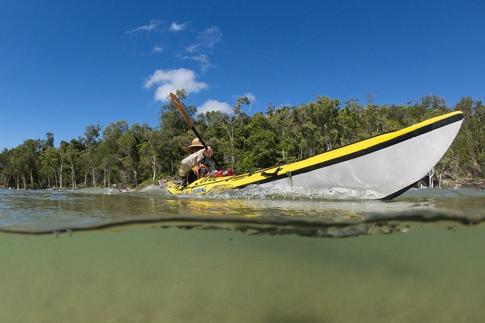
Sea kayaking at sunrise off South Mission Beach is the perfect start to a Tropical North Queensland road trip. (Image: Mark Watson)
That early start paid huge dividends: along with the groper, we’d also been fortunate enough to spot manta rays, green sea turtles, the ubiquitous hermit crabs and some Spanish mackerel splashing about close to shore. It had been an immensely satisfying experience – and it would have been great to explore further along the coast and out to the nearby islands – but the mountains were calling.
Tropical North Queensland’s catchcry is “Where rainforest meets the reef”. It would be easy to write that off as just a clever marketing strategy were it not for the fact that it is so accurate in its description of this area. The narrow coastal region, dotted with sugar cane fields and banana plantations, is sandwiched between the steep, rainforest-clad mountains of the Great Dividing Range to its west, and the waters of the Coral Sea – and the Great Barrier Reef – to the east.
The reef is, of course, a huge drawcard for visitors, but to just dismiss the hinterland region, encompassing the savannah plains, mighty rivers, high waterfalls and rolling green hills of the Atherton Tableland, would be a big mistake, and one we weren’t going to make. There are any number of routes from Cairns that will take you up high onto the tablelands, but we were keen to take the back way, and had opted to follow the historic Kirrama Range Road that climbs up and over the rugged Cardwell Range to our overnight camp at Blencoe Falls.

The timber bridge crossing Blencoe Creek takes you from the camping ground to the lookout at Blencoe Falls. (Image: Mark Watson)
Kirrama Range Road was built during the Great Depression to help the timber industry reach forests up in the hinterland and provide much-needed employment and access to the area. Construction began in 1936 and at the time was viewed as one of the state’s most impressive feats of engineering. Dug into the side of the mountain, the road was constructed nearly entirely by hand, with wheelbarrows, horsedrawn drays, jackhammers, picks and shovels used by the workers to hack a route through the rugged landscape to the precious timber reserves.
There are three monuments along Kirrama Range Road, with the most impressive history being attached to the one at Tuckers Lookout, named in honour of surveyor George Tucker. He was a member of the original survey party that had to slog through near-impenetrable, steep mountain country, fording numerous waterways and coping with the region’s high rainfall, all while trying to figure out how to build a road that could withstand these fierce conditions. The end result is both an engineering marvel and testament to all those who were involved in the project.
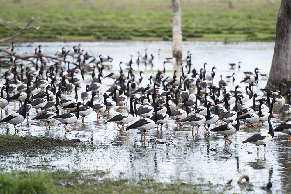
A flock of magpie geese near the road to Mareeba Wetlands. (Image: Mark Watson)
Further proof of the roadworkers’ prowess is the fact that the Kirrama Range Road is still here today, and it offers visitors a memorable drive over the Cardwell Range, passing through terrain ranging from dense tropical rainforest to rocky, dry savannah grasslands. You don’t need a four-wheel-drive for this route (the only caveat being it can get very slippery in wet weather) but you do need to be cautious, because the road is narrow and the corners are blind; take your time and you’ll get through unscathed.
Our drive up the mountain was uneventful and relaxing. The rainforest envelops the road and we only passed a few vehicles coming the other way. Short stops at both Tuckers Lookout and then Murray Valley Lookout, with its views across Kirrama and Girringun national parks, broke up the journey and provided the chance to appreciate the scale of the region and its variety.
This was never more evident than when we reached the road’s highest point and drove across what was an abrupt change in terrain and vegetation. It was similar to a border crossing, with an invisible demarcation line separating lush rainforest on one side and, not more than a vehicle’s length further on, the open savannah grasslands on the other. The change really is that dramatic, with the only constant the road itself.

Wallicher Falls, fed by Henrietta Creek, is reached via an 800m walk through lush rainforest from the Palmerston Highway. (Image: Mark Watson)
Blencoe Falls sits in the north-west section of Girringun National Park. Like the park itself, the waterfall is huge, with a drop of about 90m to the first large pool, before it snakes down a near-vertical gorge a further 230m. And it is impressive – as is the national park camping ground, nestled beside Blencoe Creek, with plenty of creekside camping spots, and clean, well-maintained toilets.
After the obligatory tent set-up and a celebratory beer, we began the 10-minute drive across the creek and around to the falls lookout on the western side of the gorge. Looking at the waterfall from this vantage point did nothing to lessen the impression of size. The water seemed to be flowing slowly off the edge of the escarpment but the dull roar carried to us by the wind disabused that assumption – there must have been a massive volume of water crashing down to the bottom of the gorge. I can only imagine what it must be like after heavy rain.
I have camped in some amazing locations over the years and rate Blencoe Falls camping ground as one of the finest. Not just for its location, or the star-filled night we were treated to, or the fact that my travelling companion proved he’s an impressive camp chef as well as a handy photographer, but also because of the perfect morning we were treated to. Being woken by the sun peaking over the tree-lined ridge to our east with its accompanying birdsong, and following that with a swim in the fresh water of the creek (with only a few small fish for company), is tough to beat. The only negative: we were there for just one day, and I would dearly like to have explored the walking tracks that surround the falls.
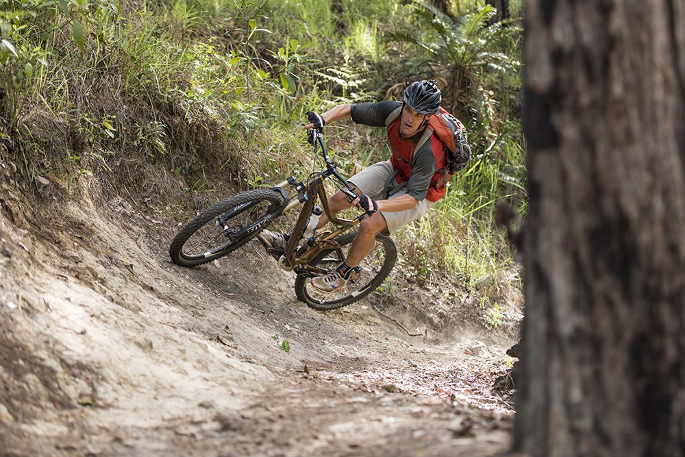
The Atherton Forest Mountain Bike Park contains more than 60km of trails for all abilities. (Image: Mark Watson)
After Blencoe Falls, Kirrama Range Road continues north-west through more savannah grasslands. As we drove, we saw increased evidence of human settlement – there are some huge cattle stations here, running the hardy Brahman cattle that are favoured in the tropical regions due to their heat tolerance and resistance to insects. These stations are all off Kirrama Range Road, however, so you don’t see much in the way of buildings or other people. This explains why, when we finally did leave the wild country behind and suddenly rejoined civilisation in the form of the bitumen Kennedy Highway, it was with a little sadness.
Over the course of the next five days that sadness dissipated as we explored the Atherton Tableland and confirmed that, rather than being secondary to the Great Barrier Reef, this region offers plenty of unique experiences for visitors. There are so many activities and things to see and do – such as hiking pristine rainforest to access remote waterfalls; riding a world-rated mountain bike trail network; spotting tree kangaroos and exploring the extinct volcano at Mt Quincan Crater Retreat; experiencing the ‘manmade’ wetland reserve at Mareeba; marvelling at the wildlife and birdlife of Rose Gums Wilderness Retreat; and much, much more.
And yes, you can take the ‘easy’ way up the Kennedy Highway directly from Cairns to the tablelands. But, as is usually the case, the ‘back way’, via the Kirrama Range Road and with at least one night camping at Blencoe Falls, will make it a more memorable experience.
READ MORE:
- 50 things to do in Tropical North Queensland
- Chasing waterfalls in Tropical North Queensland
- Best bird-watching spots in Tropical North Queensland

