New Zealand: land of plenty
AS WE HOVER ABOVE the Bay of Plenty in a Robinson R44 chopper and look towards the horizon, I can almost see the curvature of the Earth.
The South Pacific Ocean seems to stretch indefinitely before us. Its immense expanse of water glistens in the early afternoon sunshine – a moving blanket of brilliant blue that reflects light as it swells.
We’re on our way to White Island, an active marine volcano located about 49km offshore of Whakatane, a small coastal town in the Eastern Bay of Plenty.
In Maori, White Island is called Whakaari, which roughly translates to “that which can be made visible”. According to local history, it got this name because of its tendency to disappear behind huge plumes of smoke and steam.
Captain Cook, the first European to sight the island, gave it its English name in 1769 because of these white clouds.
Whale Island, Bay of Plenty
As the helicopter’s blades slice through the air, carrying us closer, the coastline behind me shrinks into the distance. A thin crust of white sand separates the enormous ocean from the fields of golden grass at Whakatane Airport, and the lush farmland and distant mountains behind it.
It only takes about 15 minutes to fly from the coast to the island. On the way, we’re kept captivated by views of Whale Island, a 143ha wildlife reserve situated about 10km offshore. B
lanketed in pohutukawa forests and kanuka shrubs, Whale Island is a green refuge surrounded by sandy beaches and rugged sea cliffs.
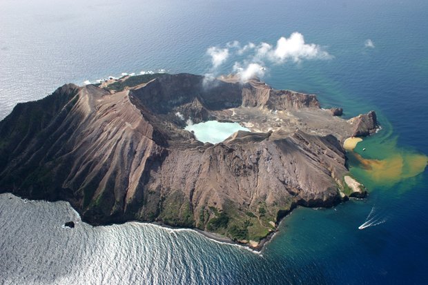
White Island
White Island couldn’t be more different. As we approach and circle over it, a thin wisp of steam rises from within the volcano’s crater. Walls of dark rock form an amphitheatre that drops down to a brightly coloured turquoise lake.
It bubbles and steams amid fumaroles spurting thick puffs of smoke and sulphur dioxide. White Island resembles what I imagine a post-apocalyptic landscape would look like.
Covered in volcanic rock, it’s completely barren, bar a cluster of shrubs on the crater’s outer walls, close to the sea.
“Be aware of your footing when we’re out on the island,” warns our pilot Mark Law, who has guided tours to White Island for the past six years. After landing the helicopter at Crater Bay, on the island’s south-east flank, he hands each of us a hard hat and a gas mask.
The mask is optional, he says, but the hard hat must be worn at all times. “The island is still in its natural state so there aren’t handrails or danger signs,” Mark says. “In places it’s very easy to break through rock with your boots, and the water and mud beneath is scalding so don’t wander off the track.”
Mark leads us on an hour-long tour of the 480ha island, past mounds of ash and rock, and alongside bright yellow vents that hiss and roar as they spurt volcanic gases.
Delicate white and yellow sulphur crystals shimmer on the ground, and trickles of acidic water run in miniature streams over the soft ash and mud towards the sea. The raw energy of the landscape is compelling, and its other-worldliness is both striking and beautiful.
White Island reaches a height of 321m above sea level, but the full volcano measures 760m from the sea floor. At its base, the volcano is close to 50 times the size of the protruding land mass.
“It’s New Zealand’s most active volcano,” Mark says, pointing out that the last time it erupted was only a decade ago. “It’s between 150,000 and 200,000 years old, which is really quite young when you think about it in volcano terms. New Zealand is between 22 and 24 million years old.”
Mark tells us the island is a summer breeding ground for up to 5000 pairs of Australasian gannets and about 60,000 muttonbirds. He explains that before White Island fell into European hands in the 1830s, early farmers used its sulphur for fertiliser and Maori used its muttonbirds for food.
Decades of European sulphur mining followed, and pieces of rusted machinery remain on the shores of Crater Bay. In part, they’re a reminder of the 1914 lahar, or volcanic landslide, that killed 10 miners when a wall of the crater collapsed.
Mark tells us that mining ceased in the 1930s, and that in 1953, the island’s current owners, the Auckland-based Buttle family, declared it a scenic reserve. And “scenic” is certainly the way to describe it.
White Island sits at the northernmost tip of the Taupo Volcanic Zone, which is a narrow belt of volcanic activity that stretches across the central North Island, and is one of the most impressive places to experience New Zealand’s geothermal wonders up-close.
Marine encounters on Whale Island
Although it’s very different to White Island, Whale Island (known as Moutohora in Maori) also comprises geothermal features. It’s no longer an active volcano – and hasn’t been for 18,000 years – but there is still volcanic activity there, including a number of sulphur springs and hot-water beaches.
To explore the area more closely I join a sea-kayaking trip with guide Kenny McCracken, a Scotsman who moved to the Bay of Plenty nearly 20 years ago, after falling in love with the area while hitchhiking around New Zealand.
He has been running kayak tours to Whale Island for four summers now. With our sit-on top kayaks loaded onto a launch we motor from Whakatane to McEwans Bay, on the island’s eastern side. While crossing the ocean, we catch sight of a number of little blue penguins skimming the water’s surface.
According to Kenny, that’s totally par for the course in these waters. “You’ll see more of them when we get to the island,” he says. “Dolphins are pretty abundant around here as well, both bottlenose and common, and we often see orcas because they’re quite frequent along this coast.”
As we approach McEwans Bay, a handful of New Zealand fur seals who have been sunning themselves on some rocks at the water’s edge slide into the ocean. “At this time of year the males are coming ashore to start marking out their territory for the summer breeding season,” Kenny says.
After a quick safety briefing we launch the kayaks and join the seals in the water. The 2m-long mammals dart below us, surfacing nearby before gliding back under the water’s surface.
“We’ll be cautious around them but in my experience, if they’re in the water they’re usually quite playful; they find the kayaks entertaining,” he says.
We paddle along a stretch of the island’s coastline, towards a series of rugged sea cliffs. Some of the seals follow us through a rock archway and into a quiet sea pool, their wide eyes gazing at us as they poke their whiskered snouts out of the water.
This island is a refuge for them. “It’s owned by the Crown, and managed through the Department of Conservation and Ngati Awa, the local iwi, or tribe,” Kenny says. “Together they’re trying to restore its natural ecology; they’ve already cleared all the pests and predators off it.”
He explains that previously the island was home to about 1500 goats, half a million rabbits and large numbers of stoats, weasels and rats. “They got rid of all that and planted 12,000 native plants on it,” he says. “The pohutukawa forest is coming back now and it’s beginning to look really good.”
Because it’s a wildlife refuge, visitors aren’t allowed to set foot on the island without a landing permit. When we reach Sulphur Bay, the end point of our kayak tour, Kenny tells us that although we can’t pull the kayaks up to the beach, we can jump into the chest-deep water and stick our toes into the sand if we want to.
I wriggle my toes deep into the sand and feel hot geothermal water surging through. I completely understand why this part of New Zealand is called the Bay of Plenty.
Source: Australian Geographic Outdoor Jan-Feb 2012
RELATED STORIES