Mt Cook and New Zealand’s Mackenzie region
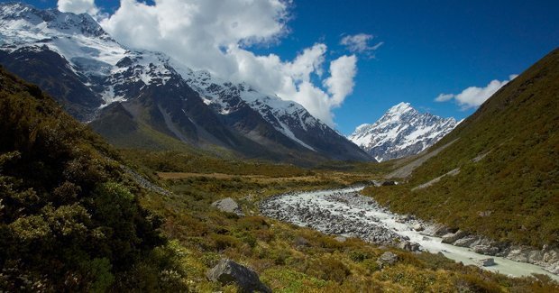
SNOW-CAPPED MOUNTAINS PIERCE the clouds above New Zealand’s South Island. At 3754m, Mt Cook (officially Aoraki/Mt Cook) is the tallest, and its summit is the nation’s highest point.
Occasionally, when westerly winds blow red dust across the Tasman Sea from outback Australia, its snow turns pink. Other attractions in the Mackenzie region include the 27km-long Tasman Glacier, Lake Tekapo and the astronomical observatory at Mt John.
Mt Cook lies within the Southern Alps, a series of mountain ranges stretching along the entire South Island. The mountains began to form some 45 million years ago, when the Pacific and Indo-Australian tectonic plates collided. They continue to rise today – Mt Cook grows by almost a centimetre each year.
The mountain is situated within Aoraki/Mount Cook National Park: a 70,700ha protected alpine region. The area offers challenging climbing – Sir Edmund Hillary honed his skills here before making the first summit of Everest in 1953.
WATCH A VIDEO OF MT COOK NATIONAL PARK
The park is a four-and-a-half-hour drive west from Christchurch, or a five-and-a-half-hour drive north from Queenstown. Many people stay in Mount Cook Village, an alpine hamlet about 12km south of the mountain’s summit. Climbing and hiking – or ‘tramping’, as New Zealanders call it – here is safest during spring and summer. In winter, the landscape is blanketed in white, and Mount Cook Village becomes a cosy retreat.
Read the full story in issue 113 (Mar/Apr) of the Australian Geographic journal.
|
|
 |

RELATED STORIES

