10 weekend adventures: Alice Springs
1. Simpsons Gap
30 mins / 18 km / W
Activity: Cycling
Drawcard: Just out of town at a prominent break in the West MacDonnell Ranges, Simpsons Gap shades a waterhole that lures black-footed rock-wallabies from their hideouts at dawn and dusk. This popular spot attracts a steady stream of tourist traffic, but a bikes-only bush track provides an escape, leading cyclists silently through mulga scrub and across seasonal creeks shaded by ghost gums and ironwoods. The 17 km sealed cycleway begins 8 km from town at the grave of John Flynn (of Royal Flying Doctor Service fame) and ends at Simpsons Gap where hiking trails will absorb any excess energy: try the Woodland Trail (17 km return).
Fuel stop: Pack a picnic and make use of the free gas barbecues at Simpsons Gap.
www.nt.gov.au/nreta/parks
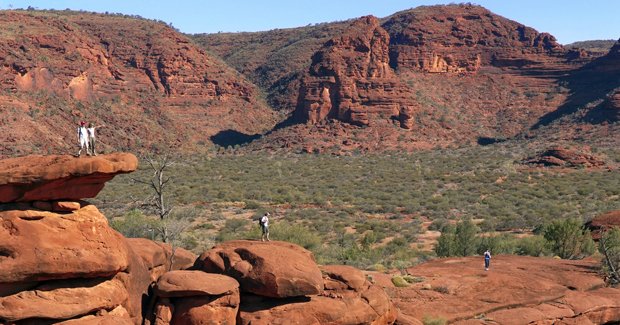
2. Ormiston Pound
2 hrs / 135 km / W
Activity: Hiking
Drawcard: Climbing beyond soaring red rock walls and up spinifex-covered slopes, hikers hover on the edge of an incredible abyss – the surprisingly expansive cavern of Ormiston Pound. The best half-day walk in West MacDonnell National Park, this rocky, four-hour route winds through an important refuge of the rediscovered long-tailed dunnart and the central rock-rat. Rated moderate, the trail climbs to the Pound’s rim for awesome views before dropping swiftly to weave along a path across the Pound and disappears into the gorge past tempting, chilly waterholes.
Fuel stop: Get snacks from Ormiston Pound’s kiosk (open in winter).
www.nt.gov.au/nreta/parks
3. Emily and Jessie Gaps
15 mins / 10 km / E
Activity: Rock art and rockclimbing
Drawcard: In small galleries at the base of these gaps in Heavitree Range, unusual rock art marks the Dreaming Trail of Mparntwe (Alice Springs) caterpillar beings. Separated by a few kilometres, both gaps are important spiritual sites and though rockclimbing is permitted, bolts are not. Expect a good range of slabby, one to two-pitch beginner routes, with more moderate routes up to Grade 17 located at
Emily Gap.
Fuel stop: Cafe-hop along Alice’s Todd Street mall.
www.redcentrerock.info
4. Redbank Gorge
2 hrs / 150 km / W
Activity: Tubing
Drawcard: At the darkened entrance to Redbank Gorge, cathedral-high walls tower above a chilly pool that disappears into a twisting chasm of marbled red quartzite. At first light the rising sun ignites the rosy rock faces and noisy crows swoop through the gorge, beckoning paddlers armed with inflatable tubes and air mattresses to brave the icy water. A 2 km walking trail leads to the pool (30 minutes).
Fuel stop: Glen Helen Resort sells the only nearby sustenance.
www.nt.gov.au/nreta/parks
5. Ewaninga rock carvings
45 mins / 39 km / S
Activity: Rock art
Drawcard: Chiselled by the hands of a thousand storytellers, Ewaninga’s petroglyph galleries adorn a cluster of sandstone outcrops, accessed via a
680 m walking trail. The rock galleries are crowded with a multitude of engraved symbols and motifs – most too sacred to reveal to the uninitiated. There is much to learn here about the Arrernte Aboriginal people, who traditionally returned to the site when rains filled the nearby claypan, to hunt game and record their stories on the rock.
Fuel stop: Bojangles in Todd St serves great native tucker.
www.nt.gov.au/nreta/parks
6. Todd River
2 mins / 1 km / E
Activity: Camel riding
Drawcard: Carving a sandy path through the heart of Alice Springs, the Todd River rarely flows for more than a few days each year. This suits the Red Centre’s ‘ships of the desert’ just fine, and boarding a camel train to cruise the dry riverbed is a favourite way to take in the MacDonnell Ranges. Phone Frontier Camel Tours on (08) 8950 3030.
Fuel stop: Frontier serves safari breakfasts and dinners.
www.centralaustraliantourism.com
7. Tnorala comet crater
2 hrs 30 mins /196 km / W
Activity: Hiking, four-wheel-driving
Drawcard: About 142.5 million years ago, a 600 m wide comet slammed to Earth, blasting out a crater that measured 20 km across. Although much eroded today, Tnorala’s crater walls rise impressively and are visible as you tackle the corrugated, 4WD-only road through wild camel and brumby country to reach the conservation park. A short walking trail (15 minutes return) reveals much about the site’s geology and its importance to the western Arrernte Aboriginal people, whose creation story tells of a baby falling from the Milky Way during a dance by a group of women.
Fuel stop: Get food and a Mereenie Loop Road vehicle permit ($2.20) from Glen Helen Resort.
www.nt.gov.au/nreta/parks
8. Larapinta Trail
40 mins / 3 km / N
Activity: Hiking
Drawcard: Setting out from the Alice Springs Telegraph Station, just outside the city centre, the Larapinta Trail stretches 223 km along the West MacDonnell Ranges to Mt Sonder. The Northern Territory’s toughest endeavour is best tackled between April and October, and walking all 12 sections demands two weeks and a bit of forward planning to deliver food stashes to campsite lockers.
Fuel stop: Organise food drops and transfers in advance.
www.larapintatransfers.com.au Check out the AG Society Larapinta trip here.
9. The Ochre Pits
1 hr 10 mins / 111 km / W
Activity: Hiking
Drawcard: Prized for its lustre and diversity of colours, the Ochre Pits’ colourful, striped cliffs have been mined for generations by Aboriginal people to create paint for ceremonial body decoration and art. Vibrant, vertical layers of purple, red, yellow and white ochres are exposed by fractures in the cliffs and walkers can check them out along the trail that continues all the
way to Inarlanga Pass (three-hour
return walk).
Fuel stop: The kiosk at Standley Chasm sells meals and good coffee.
www.nt.gov.au/nreta/parks
10. Rainbow Valley
1 hr 45 mins / 100 km / S
Activity: Hiking and photography
Drawcard: Camped upon “Ewerre”, one of the last hunting and gathering grounds of the southern Arrernte people, travellers wait all day to witness the setting sun light up the aptly named Rainbow Valley. Painted with an unlikely spectrum of colours for such an arid landscape, the sandstone bluffs, ridges and freestanding cliffs are best explored via the walking trail to Mushroom Rock. A rare photographic moment occurs when rain falls, sparking the bright purple bloom of Parakeelya and reflecting the cliffs on a water-
covered claypan.
Fuel stop: Head south to Stuarts Well Roadhouse for classic Aussie fare.
www.nt.gov.au/nreta/parks
Source: Australian Geographic Adventure May/June 2010
RELATED STORIES
Other weekend adventures

