Maps of Australia: charting our history
THE MOST INTRIGUING ITEM in the National Library of Australia’s (NLA) vast map collection isn’t one of their ancient globes, or charts of the new world drawn on animal skin. It’s a siltstone tablet about the size of your hand, etched with concentric lines and thought to have represented the world to the Kimberley’s indigenous people.
“Not much is known about its origins, purpose or age,” says Dr Martin Woods, the curator of maps for the NLA, in Canberra. “The library has been the custodian of the stone since it was handed to us for safekeeping in the 1970s.”
The NLA holds almost 1 million maps spanning more than 500 years. The collection owes its breadth and depth to the diligence of late 19th- and early 20th-century map collectors, whose collections were acquired by, or bequeathed to, the library.
“I am constantly amazed when we are acquiring items,” Martin says. “We’ll see a map selling for tens of thousands of dollars and check to see if we’ve got it and find out we already have three editions.”
Maps: Snapshots of history
As physical entities, maps are spatial representations of places, but they’re also snapshots of history. Older maps in the collection are so much more than what we imagine maps to be: they show the course of discovery and place-naming. In some cases they’re the first record of a land that’s totally unknown to people from other places or they reveal specific aspects of an age of discovery.
For instance, in a British map of our region published in 1811, the Australian continent is given the label Notasia. “Rather than being a pejorative term, it was really a clumsy attempt to distinguish Australia from other parts of Asia,” Martin says.
Maps from Australia’s early post-settlement history show land use, settlements and cultural groups that no longer exist. The 45 maps drawn by amateur ethnographer Daisy Bates in the early 20th century capture fascinating details of indigenous social groups, placenames and topographic features of interest such as waterholes, ranges and lakes.
Eddie Mabo’s maps, which heralded formal recognition of native title and legislation supporting it, were hand-drawn on lined notepaper and shaded with coloured felt-tip pens. They show the traditional ownership boundaries of the Murray Islands in Torres Strait.

Eddie Mabo’s hand-drawn map, circa 1981. Drawn with felt-tip pens, this map of land portions and boundaries of
Murray Island in Torres Straight was used in the 1992 High Court cast that affirmed Native Title rights.
Maps: Amazing feats
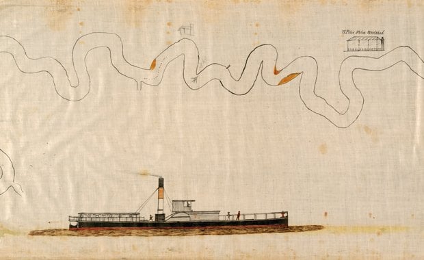
Other maps detail amazing feats, such as Charles Kingsford-Smith’s annotated charts from his record-breaking trans-Pacific flight in 1928. Wilson Budarick’s river-pilot charts, drawn on lengths of calico, document the routes of paddle-steamers on the Darling River in the early 20th century.
“We even have maps of places that were never developed,” Martin says. “We have a plan for a town north-east of Bunbury in WA called Australind that is just as impressive as [Colonel William] Light’s plan for Adelaide.” While Australind exists today on a much smaller scale, the grand plan for the town was abandoned due to poor soils and climate.
Agents in Jakarta and London are employed by the library to keep an eye on the global markets for rare and collectable maps with Australian significance. Martin is buzzing about a 1730 map of shipping hazards in the Indian Ocean, drawn by Dutch East Indies cartographer Abraham Anias, which the library recently acquired from an agent in Amsterdam.
“It’s like a pirate map,” Martin says with a grin. “It’s very wrinkled and drawn on vellum, or deerskin. It’s a fantastic item to have and there are no examples like it in Australia.”
Martin also has some more modest cartographic acquisitions in his sights. “The early classroom wall maps of Australia and the States, produced between the 1890s and 1960s, may not be at the high end of collectables but these are very rare,” Martin says. “Although they were usually backed with canvas, they were so well used that very few of them remain.”
Maps: New technology
In 2002 the NLA began the epic task of scanning the map collection and placing the images on the Internet. While Martin and his team have hardly made a dent in the collection – about 7000 items have been scanned so far – the project is slowly gathering pace.
The growing popularity of car GPS receivers and Internet mapping is also changing the landscape of cartography and map collection. “People are now producing a lot of maps which never find their way into a print form,” Martin says. “They’re just a dataset on someone’s computer.”
The library is developing ways to tackle this shift to digital mapping, such as collecting datasets on DVDs. “Today’s maps are tomorrow’s history and if we don’t collect these maps there’s no guarantee they will be available for future research.”
Source: Australian Geographic, Issue 90 (April-June 2008)
RELATED STORIES

