Seafloor landslides point to ancient tsunamis
UNDERWATER LANDSLIDES MAY HAVE been triggering tsunamis along Australia’s eastern coast up to 15 million years ago, a study has found.
On Tuesday a research team, led by geologist Dr Tom Hubble of The University of Sydney, announced the completion of a 17-day study of the seafloor between Fraser Island and Byron Bay on Queensland’s south-east coast, identifying a number of probable underwater landslide sites.
These, say researchers, may be a little-considered and significant source of Australian tsunamis.
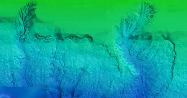
Seafloor landslides on Australian coast
Using sonar surveying tools, the researchers bounced soundwaves off the seafloor to reveal its depth and shape. Tom compares the technique used to get coverage of the area to “mowing the lawn”.
“We just go backwards and forwards and we mow the lawn in a particular piece of seafloor that we are interested in.”
From the 3-D maps they’ve produced, the researchers have identified the markings of a number of underwater landslides. “The scar that is left looks like someone has got a big ice cream scoop and dragged it downhill,” says Tom.
Earthquakes may have caused underwater landslides
The researchers then drilled down into the seafloor to obtain sections of sediment up to 50m long and estimated at 1 million years old.
Tom says they are looking at the cores for “a transition between what appears to be relatively recent and quite soft sediments to really firm, compacted material.” This transition is quite abrupt, as is the case when new, soft sediment falls on top of harder sediment following a landslide.
The research team is also looking into how the landslides occurred. They may have been caused by earthquakes, says Tom, or by cold, dense water that moved up from Antarctica along the seafloor weakening and applying pressure to the slope at the edge of the Australian continent.
Tom describes this “shaking and erosion” as the most likely trigger of the landslides.
These are thought to have been at big enough and at shallow enough depths to cause tsunamis along the Australian coast.
Underwater landslides: source of Australian tsunamis
James Goff, a coordinator of the Australia-Pacific Tsunami Research Centre, welcomes the study and says he believes that underwater landslides are a “forgotten source of tsunamis.”
“The people who model tsunamis have to think about modelling submarine landslides, because they may well be the most significant source of tsunamis for Australia,” says James.
However, the landslides are thought to occur so infrequently that they currently present a very small risk to Australian communities.
“The circumstance needed to trigger one of these landslides, is a moderately large and shallow earthquake measuring more than 6.5 or 7 on the Richter scale, which might happen once every 5000 to 10,000 years in south-eastern Australia,” says Tom.
“Importantly the data we collected on the voyage indicate that in fact most of the landslides probably occurred at least several million years ago and that they may be older still.”
MV Limerick shipwreck confirmed
On the same voyage, at the request of Australia’s Marine National Facility, the researchers also used their sonar equipment to successfully confirm the location of MV Limerick, a merchant ship that sunk 18km east of Ballina in 1943, after being torpedoed by a Japanese submarine.
“There was an exhilaration in the operations room when we went over the top of it,” says Tom.
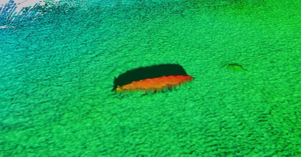
Sonar image of MV Limerick shipwreck (Credit: Tom Hubble and Tara Martin)
RELATED STORIES

