New Zealand earthquakes linked, say experts

TUESDAY’S EARTHQUAKE IN New Zealand is connected to last year’s September quake in Darfield, Canterbury, a seismologist from GeoScience Australia has confirmed.
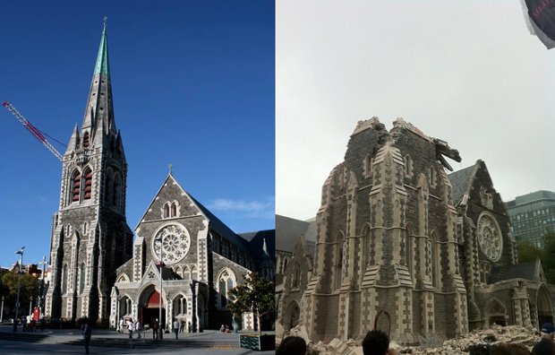
The massive earthquake shook the South Island city of Christchurch at 12:51 pm local time and measured 6.3 on the Richter scale. Its epicentre was 10 km south-east of Christchurch, near the town of Lyttleton at a depth of just 5 km. While 75 fatalities have been confirmed, authorities are expecting many more.
Though yesterday’s quake is “certainly related” to the quake of six months ago, earthquake seismologist Trevor Allen told Australian Geographic, “it’s too early to tell if it’s the same faultline – it might be a continuation of the same (faultline) structure or a nearby, adjacent structure.”
New Zealand is on the tectonic plate boundary between the Pacific Plate and the Australia-India Plate, the boundary of which is east of the North Island and crosses to the west of South Island. While Christchurch is not on the plate boundary, it is near to related secondary faults that result from the bend in the plate boundary to the north, says Dr Gary Gibson, a seismologist at the University of Melbourne.

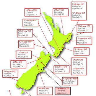
Map: Large earthquakes in NZ. (GNS Science) View map
The Greendale fault line from the Darfield quake was a previously unknown fault and the earthquake took scientists by surprise.
Stress from the Greendale fault would have moved along the same fault line or transferred to a nearby fault line, Trevor says, causing the catastrophic groundshaking that rocked Christchurch yesterday. The epicentre is located just 25 km east of September’s and was “essentially a direct hit on Christchurch” Trevor says.
New Zealand’s Deputy Prime Minister Bill English says the earthquake is “larger and more devastating” than September’s Darfield quake. Indeed, Gary says “This is by far the largest earthquake to have occurred in the Christchurch region in historic time.”
Shallow quake
Last year’s Canterbury quake rocked an area 40 km to the west of Christchurch and although no fatalities were recorded, widespread destruction of buildings and infrastructure caused millions of dollars of damage. Whilst stronger in magnitude, at 7.1 on the Richter scale, last year’s quake was dampened by its depth, measured at 10 km underground.
Yesterday’s quake was just 5 km below the Earth’s surface. Anything less than 10 km deep is considered a shallow quake.
“The further shock waves have to travel, more energy is able to decay” says Trevor who also points out that Christchurch sits on deep alluvial sediment which is prone to amplifying seismic waves. “Severity of earthquakes depends on the combination of magintitude and depth, but the type of ground is very important too.” Bedrock and firm sediment incur less severe groundshaking.
The main davastation, though, is simply a matter of the epicentre’s location, close to a major city, Trevor says. “The key thing [about yesterday’s event] is that based on initial tests, 10 times as many people were exposed to groundshaking than September, which is commensurate to the damage caused in downtown Christchurch.”
The worst has passed
Another common side-effect of earthquakes is liquefaction, the processed by which shaking of the ground causes the soil to behave like a liquid. The result is like quicksand, similar to when you dig a whole in wet sand at the beach.
Owing to the pressure transferred along the same or adjacent fault line, the likelihood of another large quake was higher after September, Trevor says. Happily though, the possibility of another large scale earthquake in the near future is unlikely. “I don’t think an earthquake of this level will happen again soon. The worst should have passed for Christchurch.”
He predicts shockwaves to last for up to 12 months and notes that a shockwave following September’s quake occurred just hours before yesterday’s event.
An example of how liquefaction works:
RELATED STORIES

