NZ quake caused by unknown faultline
NEW ZEALAND AUTHORITIES BELIEVE the 7.1 magnitude earthquake that struck the South Island city of Christchurch early Saturday was most likely caused by a previously unidentified faultline.
The quake – which was slightly larger than the devastating quake which struck Haiti in January killing over 200,000 people – caused the ground to lift by one to two metres in places, damaging buildings and infrastructure, but only hurting two people.
“In Haiti, the earthquake occurred closer to the populated area and there was a much larger number of people affected. But the most important thing is that New Zealand has a very good building code that they apply very strictly,” says Kevin McCue, director of the Australian Seismological Centre in Canberra. “I attribute [the small amount of damage] to their strong engineering.”
Christchurch earthquake unusual circumstances
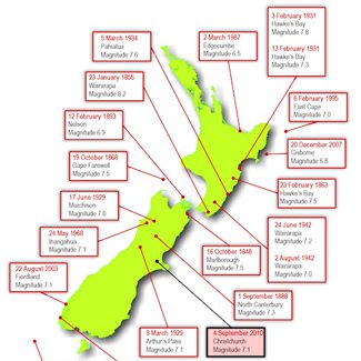
Map: Earthquakes in NZ. (GNS Science) View Large Map
Geologist John Begg from New Zealand Government Research Body GNS Science says the fault lay beneath river gravel about 18,000 years old, “indicating that this part of the fault has not ruptured since at least this time… We had no reason to know that it was there beneath the gravel.”
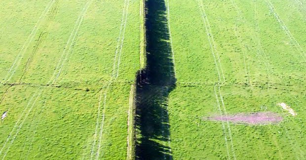
The epicentre of Saturday’s earthquake struck 30 km west of Christchurch near the small town of Darfield, at a depth of 10 km, and Jennifer Coppola from GNS Science says it was the result of one major tremor. “We’re actually still trying to figure it all out,” she told Australian Geographic. “But I can tell you that there was one major shock that rippled to the surface.”
According to scientists who visited the affected area on Saturday, a 22 km-long fault trace was visible running roughly from east to west. Dozens of aftershocks were felt over the weekend, and are expected to continue for weeks across a region that is “an unlikely area of earthquake activity,” according to Kevin.
“Like the earthquakes we periodically experience in Australia [the quake was in the middle of a plate] – rather than along the plate edge,” says Kevin. “It’s very unusual.”
Fault line was a simple shear, not expected
He says the fault responsible for Saturday’s quake was “a real simple shear” that appears to run from east to west. It is not connected to the alpine fault of the Southern Alps, where Kevin and geologists have been expecting an earthquake for a number of years. However, he says the 7.1 tremor “might excite an earthquake” there…If it happens it’ll certainly be in the next weeks or months.”
The earthquake was the most damaging to hit New Zealand since 1931, when the Hawkes Bay region of the North Island was struck by a 7.8 magnitude quake, devastating the cities of Napier and Hastings and killing around 256 people.
New Zealand sits on the boundary between the Australian and Pacific tectonic plates, and is being pulled apart almost imperceptibly as the plates shift. Stresses in the Earth’s crust along the country’s plate boundary have caused it to break into fragments that move against each other along fault lines. On average New Zealand experiences 200 noticable earthquakes each year, earning it the nickname “the Shaky Isles”.
RELATED STORIES

