Bishop and Clerk Trail, TAS
MARIA ISLAND WAS first inhabited by the Oyster Bay tribe of Aborigines and was named by Abel Tasman in 1642. The island was used by whalers and sealers in the early 1800s until 1825 when a convict settlement was established on Maria Island. In 1884 an Italian entrepreneur named Diego Bernacchi created a number of industries on the island including wine and silk making, fruit growing, a tourist hotel and a cement works. Remnants of the island’s many historic buildings can still be seen today. In 1971 the island was officially declared a national park. Over time, Maria Island has been used as a wildlife refuge for threatened species and is now abundant with native pademelons, forester (eastern grey) kangaroos, bennetts wallabies, native hens and Cape Barren geese.
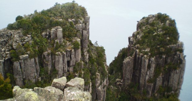
There are a number of walks on the island. The highest point on the island is Mt Maria at 710 m which is a six to seven-hour walk. However, Bishop and Clerk at 620 m has the most spectacular views. Bishop and Clerk was named after the two towering dolerite columns which resemble a bishop wearing a mitre, followed by a clergyman.
1. Start/finish
The walk starts at the National Park office (Commissariat Store) where park entry fees apply upon arrival. The hardest part of navigating this walk is trying to find the start of the track. The start (which is wide enough for a vehicle) runs parallel to Bernacchi Creek on the north side of the camp ground (the opposite side of the creek to the Darlington settlement).
2. After about 700 m you should reach the cement works ruins from the early 1920s. After a further 200 m, you will reach some more ruins, a sign and a track junction. Follow the track to the left and avoid the track to the right which is the Reservoir Circuit walk.
3. In a further 200 m the track opens up into a grassy area. Continue uphill past the limestone quarry on the right to the edge of the fossil cliffs and a sign. Turn right and walk parallel to the cliff line along what is known as Skipping Ridge. From here you will get a great view and photo of Bishop and Clerk. Extreme care should be taken along the cliff edge particularly with children as there are no fences.
4. After 1 km the track will begin to narrow, climb and leave the coastline. The vegetation also changes from casuarina to eucalyptus trees.
5. After 2 km you will reach a scree slope. There are markers to guide the way on a rocky dolerite track which zig-zags its way up the scree slope and to the left.
6. The final 100 m climb to the summit includes some basic rock scrambling.
7. Once you reach the flat tops of the 620 m summit the reward is one of the best views you will ever see with the Freycinet Peninsula (Wineglass Bay) and Schouten Island to the north, the Tasmanian mainland to the west and the massive dolerite columns and a 620 m vertical drop to the Tasman Sea below to the east. If you are lucky, you may even spot some whales or dolphins. This is a great stop for lunch before returning by the same route.
Fact file: Bishop and Clerk Trail, Tas
Distance: 10km.
Time: 4 hours.
Start/Finish: National Park’s office (Commissariat Store), Darlington, Maria Island.
Nearest town: Triabunna.
Best season: Summer.
Maps: TASMAP Schouten 1:25000 Topographic Map, TASMAP Maria Island National Park Map; Parks and Wildlife Service Tasmania – Walking Notes – Maria Island National Park – Bishop and Clerk.
Accommodation: Basic bunkhouse-style accommodation is available in the old penitentiary at Darlington. Campsites are also available at Darlington, French’s Farm and Encampment Cove. Alternatively, you can stay on the mainland and travel to Maria Island as a day trip.
Getting there: Triabunna is about a 90-minute drive from Hobart. Maria Island is about a 30-minute boat ride from Triabunna.
Terrain: Continuous uphill climb on a good track, scree slope and a few small rock climbs near the summit.
Food/Drink: All provisions must be carried to the island as there are no shops.
More info: Website

