
Walking is one of the most accessible outdoor activities. Thankfully, Australia is chock-full of some amazing foot-borne adventures, whether they are short sojourns to breathtaking viewpoints, or multi-day epics that take you deep into remote parts of our spectacular country. In this, our second of a new series on great Australian rambles, we reveal five of our favourite walks in the beautiful state of Victoria.
Wilderness Coast Walk
Distance: 100km one way Time: 5 days Difficulty: Hard
In the far eastern corner of Victoria lies Croajingolong National Park, close to the border with NSW. There is little access to this beautiful park – it’s been left to the birds, the wind and the waves. The aim is for this wilderness area to exist in as near a natural state as possible. This long-distance walk winds along the coastline in a south-westerly direction from Mallacoota to Bemm River via Point Hicks Lighthouse (and it’s also possible to walk north from Mallacoota to Nadgee in NSW).

It’s a rugged walk, with long beach sections, river crossings, fallen trees and sometimes overgrown trails, but an exceptional one if you love a sense of isolation and feeling close to the natural world. The best section can be done as a three-day walk in either direction if you can arrange transport – Mallacoota to Benedore River campsite (18km), Benedore to Wingan Inlet campsite (14km), Wingan to Thurra River campsite (20km). There is lighthouse accommodation at Point Hicks near Thurra River. Campsites must be booked with Parks Victoria, and you’ll need topographic maps and tide charts.
Razorback to Mt Feathertop
Distance: 22km return Time: 7–8 hours Difficulty: Hard
Standing at 1922m, Mt Feathertop is Victoria’s second highest mountain (after Mt Bogong). This picturesque trail above the tree line from Mt Hotham to Feathertop’s summit follows the craggy spine of the Razorback Ridge. Trek through open snow grass fields, low shrubs and snow gum woodlands, and pass over a number of rocky bluffs. From the Feathertop peak, you’ll feel on top of the world with alps and valleys in every direction.
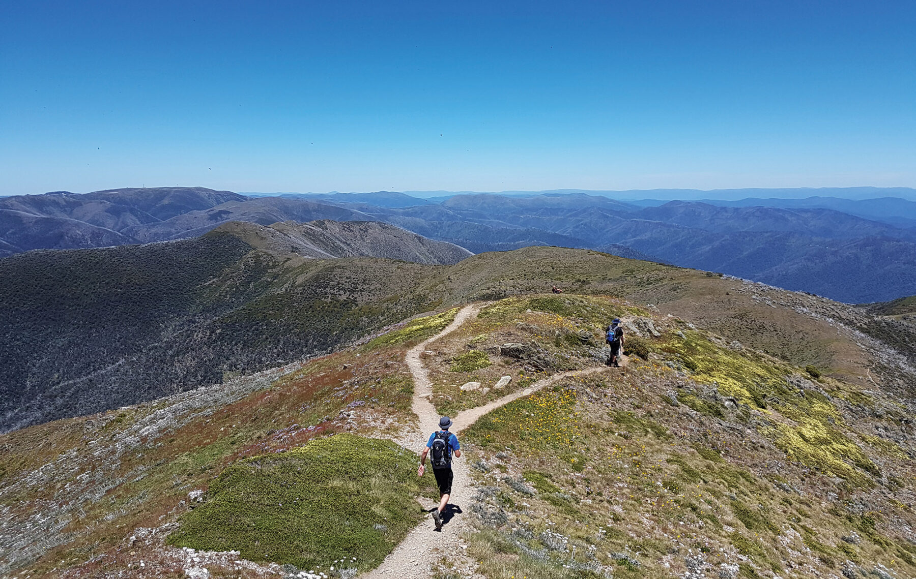
The track starts opposite the A-framed Diamantina Hut on the Great Alpine Road, 2km before Hotham Village. The well-defined track heads north along the ridge, rising to a knoll at the top of Bon Accord Spur (an alternate route to Harrietville) before descending into a steep-sided gully named the Big Dipper. Once out of the gully the trail continues around the eastern edge of the Razorback, through a patch of snow gums and across flowery meadows. A long stretch along the ridge will have you taking in the endless ranks of mountain ranges, before the route swings right at Champion Spur to head beneath the rocky bluffs of Twin Knobs. There’s an impressive rock garden wedged into the side of the craggy peaks and in summer, this area is blanketed in wildflowers.
Hugging the western side of High Knob (1801m), the path drops down to Diamantina Spur junction and Federation Hut soon comes into view to the north-west. This is a good place to rest before the final ascent or to seek shelter if the weather turns bad. Just past the three-way junction in a col below Little Mt Feathertop, keep right to begin the final climb to the summit. It’s steep and involves some scrambling over loose shale but the effort is absolutely worthwhile. Note that the razorback ridge is very exposed, and walkers should be prepared for poor weather at any time, including rain, snow and strong winds (even in summer). Conditions can change extremely quickly.
Tarra Valley Loop
Distance: 8.2km circuit Time: 2.5 hours Difficulty: Easy
Little known outside the state, Tarra-Bulga National Park in South Gippsland is a rare oasis of cool temperate rainforest harbouring enormous mountain ash trees and exquisite fern gullies. You might spot the South Gippsland koala and hear the calls of lyrebirds, whipbirds, and yellow-tailed black-cockatoos. There are several short walks from the park visitor centre that can be combined into a longer loop.

Starting from the visitor centre at Balook, where you can pick up a map, take the Link Track to join the Scenic Track through a very beautiful forest section to Corrigan Suspension Bridge. Cross the bridge to take Ash Track, then turn left onto Lyrebird Ridge Track. From the picnic area continue along Forest Track for 2km. At the next junction continue left to reach Wild Cherry Track, then return to the same junction, now heading left along Old Yarram-Balook Rd to reach the main road. Turn right to return to the visitor centre.
To further explore this magical region, you can walk a section of the Grand Strzelecki Track, which connects parts of Morwell National Park, Tarra-Bulga National Park, the Gunyah Rainforest Reserve, and 30,000ha of privately managed protected forests. This 100km trail is maintained by dedicated volunteers and topographic maps are available from their website, grandstrzeleckitrack.org.au.
Bells to Anglesea
Distance: 14km one way Time: 4 hours Difficulty: Medium
This coastal walk south of the Bellarine Peninsula is part of the Surf Coast Walk, a 44km walk from Point Impossible, all the way along the coast to Fairhaven, passing through magnificent ironbark forests and coastal heathlands, along towering sea cliffs and curving crescents of sparkling sand beaches. It also takes in some of the Surf Coast’s popular tourist towns along the way, which means that walking between accommodation is very simple.

This accessible walk is broken into 12 short sections so can be tackled as half day walks or one long-distance walk over 2 or 3 days. Sections 5 and 6 run through Great Otway National Park and have the most wild and remote feel. Section 5 starts from Bells Beach, where the Rip Curl Pro Surfing Competition is held every Easter thanks to its fierce reef breaks. The path follows rugged cliffs to climb up to the Jarosite Headland, then heads down through the undisturbed bushland of Ironbark Basin and along the Koori Cultural Walk to reach expansive views from Point Addis.
From the Point (Section 6) there’s a stretch of untamed beach to Red Rocks before the path ascends to the cliff again where you can breathe deeply and watch the breakers roll in. Finally, descend through bushland, where there is a good chance of spotting kangaroos and wallabies, and walk through the foreshore reserve to the Anglesea River and township.
Falls to Hotham Alpine Crossing
Distance: 37km one way Time: 3 days Difficulty: Hard
Traversing the Bogong High Plains with pristine mountain scenery, the Falls to Hotham Alpine Crossing (FHAC) is fast becoming one of Australia’s most iconic multi-day treks. Connecting the alpine resorts of Falls Creek and Hotham, the trail winds along mountain ridges through snow gum woodlands and grassy plains blanketed in wildflowers, over rocky summits, and past historic huts.
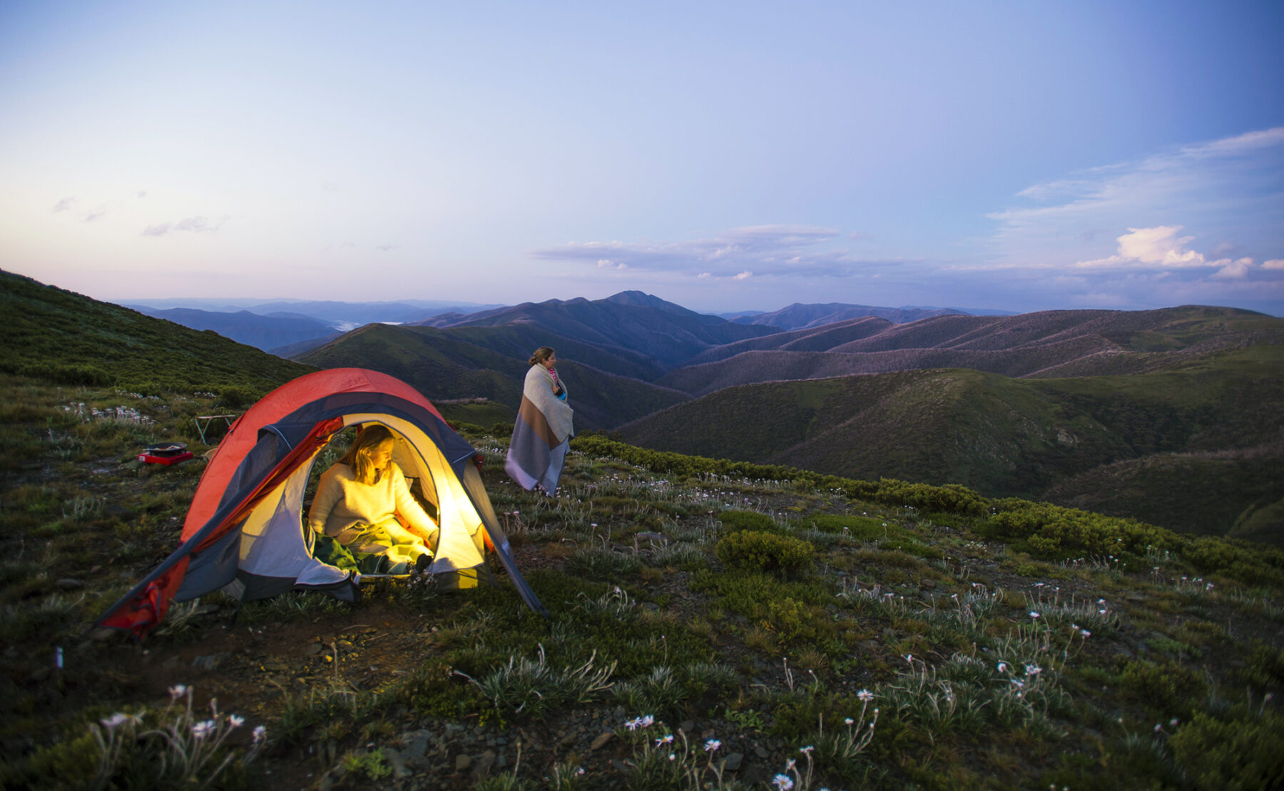
This 37km hike is usually completed over three days, sleeping on camping platforms provided along the way. However, with a car shuffle or pick up, the walk can be split into two day-walks. From Heathy Spur to Cope Hut (14km) or Cope Hut to Mt Loch carpark (23km). Camp platforms have to be booked with Parks Victoria although you can camp anywhere if you leave no trace. As always, in alpine areas, walkers must be prepared for every kind of weather.


