Walking is one of the world’s most accessible outdoor activities. Australia is chock-full of memorable walks, whether short jaunts, or multi-day monsters, with the Apple Isle regarded as home to some of this country’s best boot-propelled adventures. In this, the final part of our great Aussie walks series, we reveal five of our Tassie favourites. Yep, it’s time to get those boots on.
Liffey Falls
Distance: 2km return Time: 45 minutes Difficulty: Easy
South of Mole Creek, the Great Western Tiers stretch east for about 80km, a brooding range of ragged bluffs dotted with alpine tarns and rivers that drain over picturesque waterfalls and through rainforested river valleys. This lovely, short walk will take you past four main cascades, starting upstream with Alexandra Falls, then Hopetoun Falls, Albert Falls and Victoria Falls (the last one is generally known as Liffey Falls). Myrtle, sassafras, and leatherwood trees dominate this cool temperate rainforest. Magnificent tree ferns and enormous eucalypts line the path to these prettiest of Tasmanian waterfalls and if you are quiet, you might spot pink robins, green rosellas, and superb fairy-wrens.

The Liffey Falls State Reserve was included within the Tasmanian Wilderness World Heritage Area in 1989. Nearby you can visit Liffey River Reserve, an area of riparian rainforest, wet sclerophyll forest and open grassland that was saved by former leader of the Australian Greens, Bob Brown. He raised funds to buy the land in 1991, and in the process created the charity Bush Heritage Australia. There is a 3.5km walking trail through the reserve. You can also visit Oura Oura Reserve with its white cottage beneath Dry’s Bluff, Brown’s home for almost 40 years.
Hobart Waterfront & Battery Point
Distance: 6km circuit Time: 2 hours Difficulty: Easy
Hobart has one of the best deepwater ports in the world. Its docks, once bristling with the masts of sailing ships, are lined with honey-coloured stone Georgian warehouses with the modern city rising behind, framed by its guardian mountain kunanyi/Mt Wellington (1271m). The docks are still busy with fishing boats, high-tech superyachts, tourist cruisers and Antarctic exploration vessels but these historic warehouses and factories now contain art galleries, restaurants, and offices. A set of sandstone steps leads from Salamanca Place, on the southern side of the waterfront, up to Battery Point. One of Australia’s oldest suburbs, Battery Point, was in days gone by the home of mariners who worked out of the port. This walk, through its narrow lanes and charming colonial-era cottages, is an invitation to explore the rich history of this area.
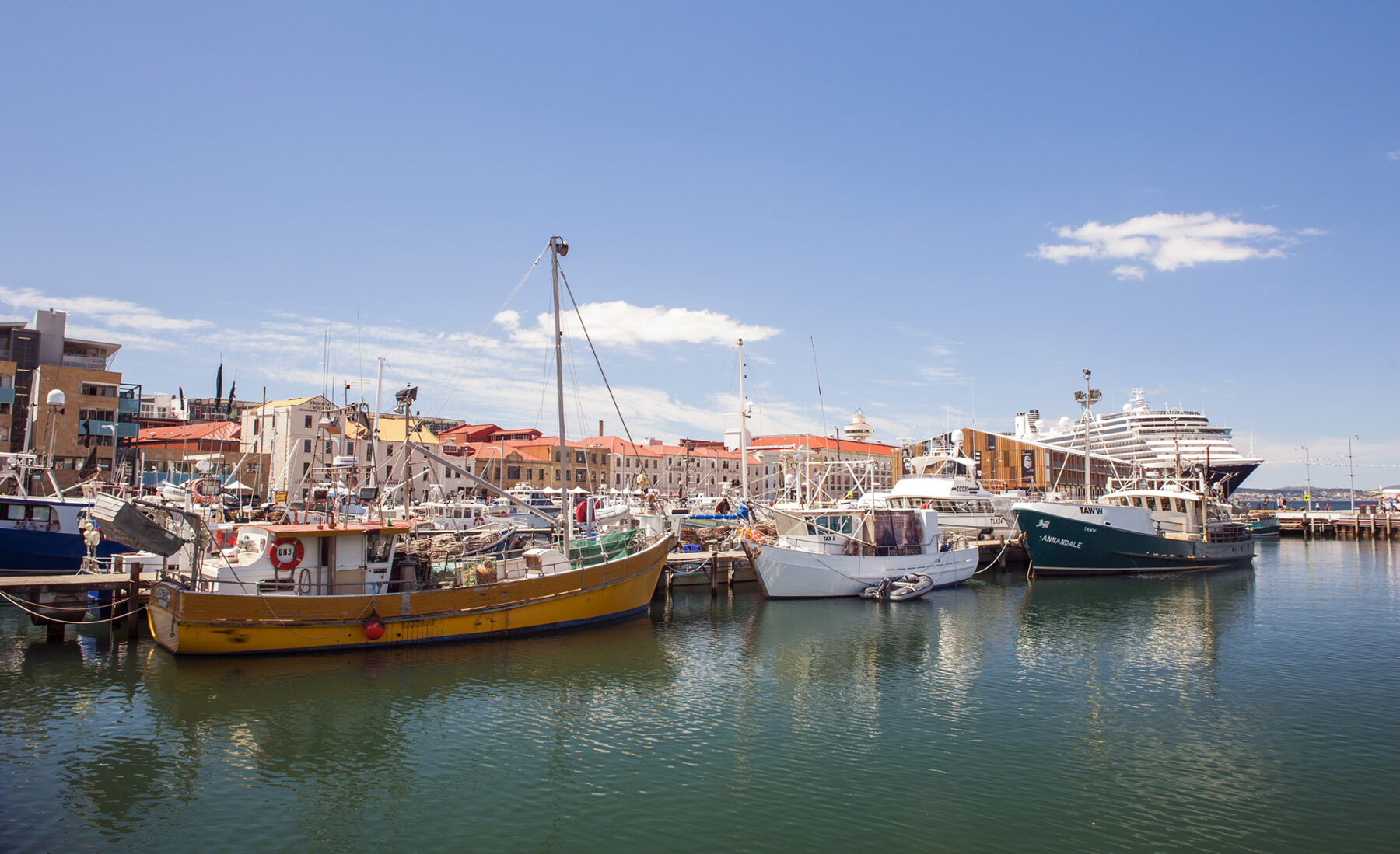
Start on the corner of Hunter and Davey Street where signs and several bronze markers in the pavement indicate the former coastline before Hunter Island was artificially joined to the waterfront. Passing the repurposed IXL Jam Factory that operated here until the 1960s, turn right onto Franklin Wharf and cross the swing bridge. The next dock on your right is the famous Constitution Dock with the historic Customs House in the background. This is where the Sydney to Hobart Yacht Race contestants moor after the race. The long glass and steel building opposite is the Institute for Marine and Antarctic Studies where you might see the Australian Antarctic Division’s icebreaker, the Aurora Australis, moored. Head through Parliament House Gardens to Salamanca Place where there are many wonderful eating spots, then climb Kelly Steps to wander the streets of Battery Point. Return via St Davids Park and Franklin Square to reach Macquarie Street’s grand historic sandstone buildings – the General Post Office to the left and the Hobart Town Hall to the right. Turn left onto Argyle Street to visit the Maritime Museum Tasmania or continue to the Tasmanian Museum and Art Gallery where you can finish your walk at the courtyard cafe.
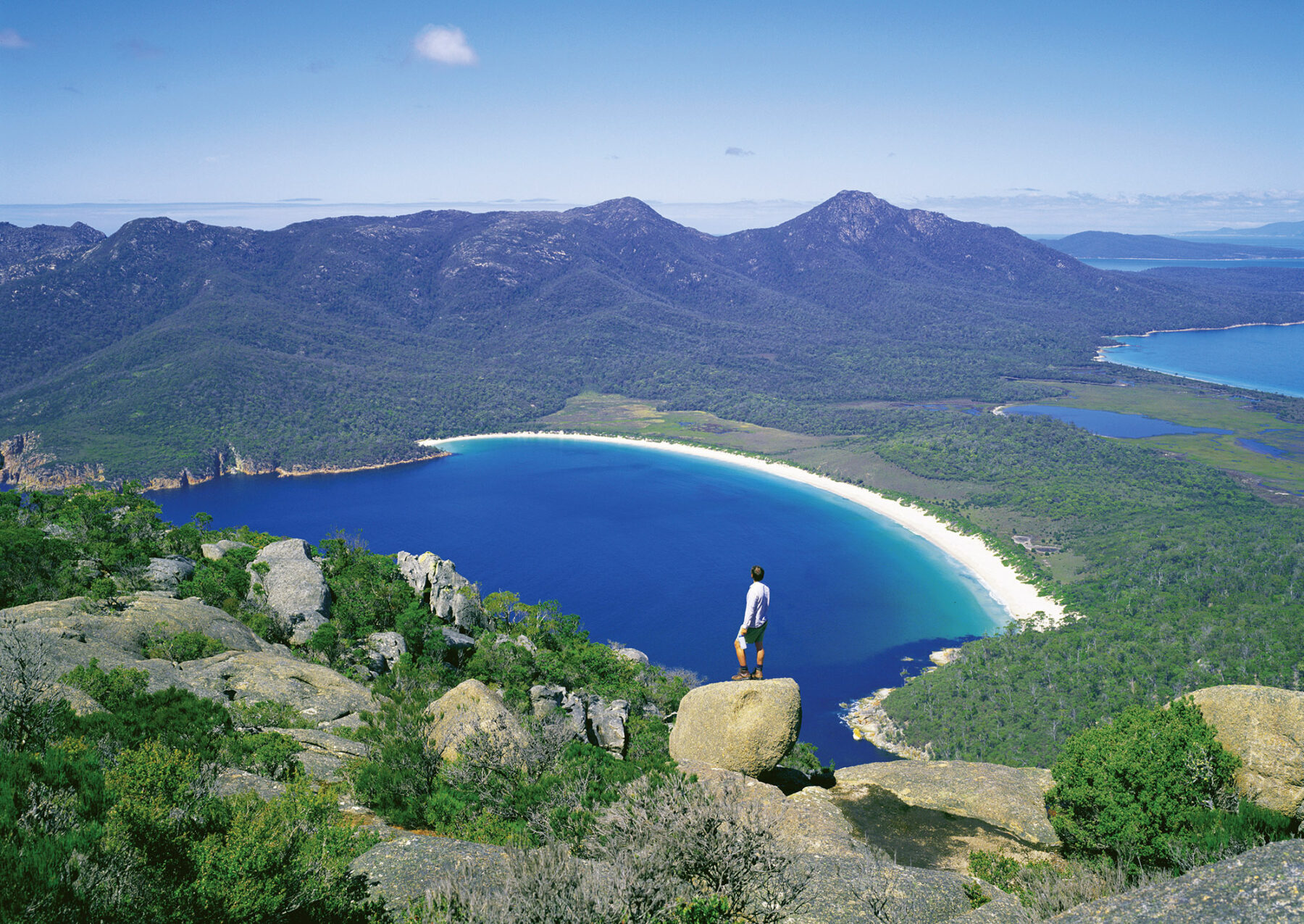
Wineglass Bay Circuit
Distance: 11km circuit Time: 4.5 hours Difficulty: Medium
Freycinet National Park, one of Australia’s finest, is best known for Wineglass Bay, a perfect arc of aqua-marine sea with a fine rim of white sand. Tucked behind the peachy-rose granite knuckles of the Hazards range, some effort is required to see it, which perhaps adds to the appeal. The bay is hidden from view on the eastern coast of the park and requires a steepish half hour climb to the Wineglass Bay lookout. This is a busy trail and many daytrippers stop right here but it’s much more rewarding to take this longer circuit and take your time to explore this enchanting peninsula. From the lookout, weather permitting, you can see across Wineglass Bay with Cape Forestier on your left. The tall mountain sitting above the bay is Mt Graham with the taller Mt Freycinet to its right.

The track now becomes narrow and rocky as it leads down a steep, south-facing, shady gully forested with tall blue gums, Tasmanian blanket bush and saggs, towards Wineglass Bay. After spending some time on this celebrated beach, you’ll turn your back on it to head west across the peninsula past Hazards Lagoon along the flat Isthmus Track towards Hazards Beach. In the understorey you may, at different times of the year, find botanical delights such as the yellow, clustered pea flowers of the native daphne, the dainty white sprays of heath myrtle (which in Tasmania can only be found in the Bicheno to Coles Bay area), white kunzea and guitar plant, as well as a host of epacrids. The rich plant life attracts fantails, robins, thornbills, and wattlebirds.
Heading north from Hazards Beach, the track undulates over granite boulders, tree roots and creek crossings, with many fine views both out to the coast and inland to the spectacular granite tors above.
Dove Lake Upper Circuit
Distance: 14km circuit Time: 4–5 hours. Difficulty: Hard
Cradle Mountain sits at the northern end of the Cradle Mountain–Lake St Clair National Park and is part of the Tasmanian Wilderness World Heritage Area. The park’s ancient rainforest, spiky mountains, alpine moorland, glacial lakes and rare Gondwanan flora and fauna make for a unique and spectacular wilderness. The Dove Lake circuit is one of the country’s best loved walks and while it is magical to wander the shores of the lake as the jagged dolerite peaks of Cradle Mountain loom above you, the challenging upper circuit offers magnificent views and a truly rewarding taste of the alpine wilderness.

From Dove Lake, the walk heads anti-clockwise to the photogenic boat shed on the shore of the lake before climbing through a forest of deciduous beech (Nothofagus gunnii) to Marion’s Lookout. Here the bracing high country winds might keep you from lingering too long over the spectacular view. The track continues to Kitchen Hut, an emergency shelter, before joining the Face Track, passing below Cradle Mountain (1545m) and Little Horn (1355m) on the way to Hansons Peak (1185m). A steep scramble down from the peak leads to a gentle descent through forest on the Lake Rodway Track, before re-joining the track around the shore of the lake.
Along the way you’ll see delicate alpine vegetation such as the cushion plant, colourful pandani trees, pencil pines and possibly even a grazing wombat. This is a steep and sometimes taxing walk but is the next best thing to doing the Overland Track if time is limited. You’ll need a topographic map, available from the park visitor centre, and to be well equipped with clothing for all weather, plus snacks to keep you going. The visitor centre can also provide details for many other wonderful short walks in the area.
South Coast Track
Distance: 85km one way Time: 7–9 days Difficulty: Hard
This epic adventure runs between Melaleuca and Cockle Creek in the Tasmanian Wilderness World Heritage Area. The trip can take walkers seven to nine days, carrying a full backpack for five to six hours a day. You’ll traverse vast button-grass plains, wild tannin-stained rivers, creeks and lakes, expansive beaches, majestic sea cliffs, memorable campsites, and the midway challenge of crossing the mighty Ironbound Range.
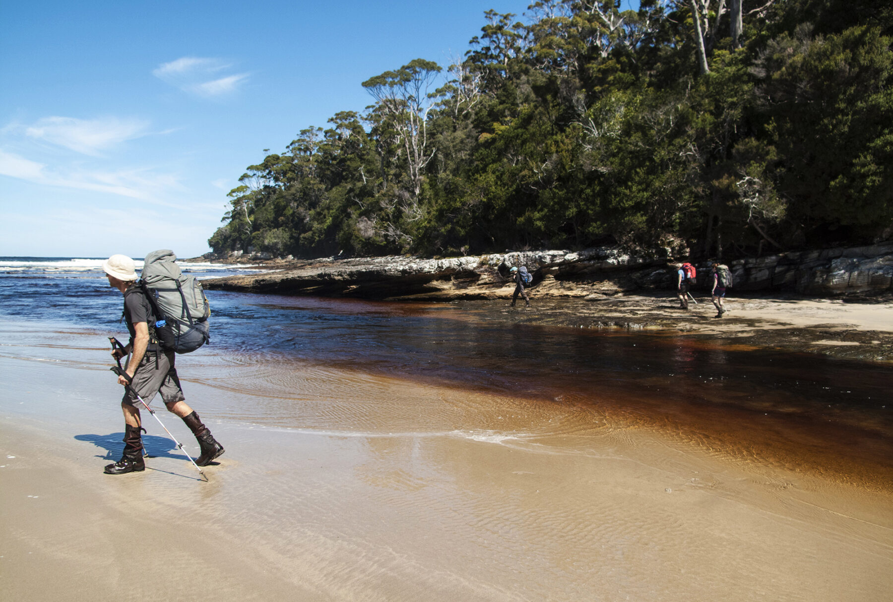
You’ll be confronted by unbelievable mud, unpredictable weather and strong winds, as the track is abutted on its southern and northern sides by the wild Southern Ocean and the wilderness area encompassed in the Southwest National Park. Immersing yourself in one of the world’s last true wilderness areas is not easy but it has just the right amount of challenge, mixed with a dose of spectacle that makes the effort more than worthwhile.