
Walking is one of the most accessible outdoor activities. Thankfully, Australia is chock-full of some amazing foot-borne adventures, whether they are short sojourns to breathtaking viewpoints, or multi-day epics that take you deep into remote parts of our spectacular country. In this, our first of a new series on great walks in Australia, we reveal five of our favourite walks in NSW and the ACT.
Grand Canyon, NSW
Distance: 6.2km circuit Time: 3–4 hours Difficulty: Medium
There are many outstanding walks in the Blue Mountains, about 130km west of Sydney, but the Grand Canyon’s expansive vistas, narrow chasms, striking canyon scenery, and a surprise around each corner, ensure this walk is one of the most popular in the mountains. Much of the walk traverses a ledge that looks down into the canyon from above but there is a wonderful section where you’ll find yourself picking your way over stepping stones along the floor of the canyon.
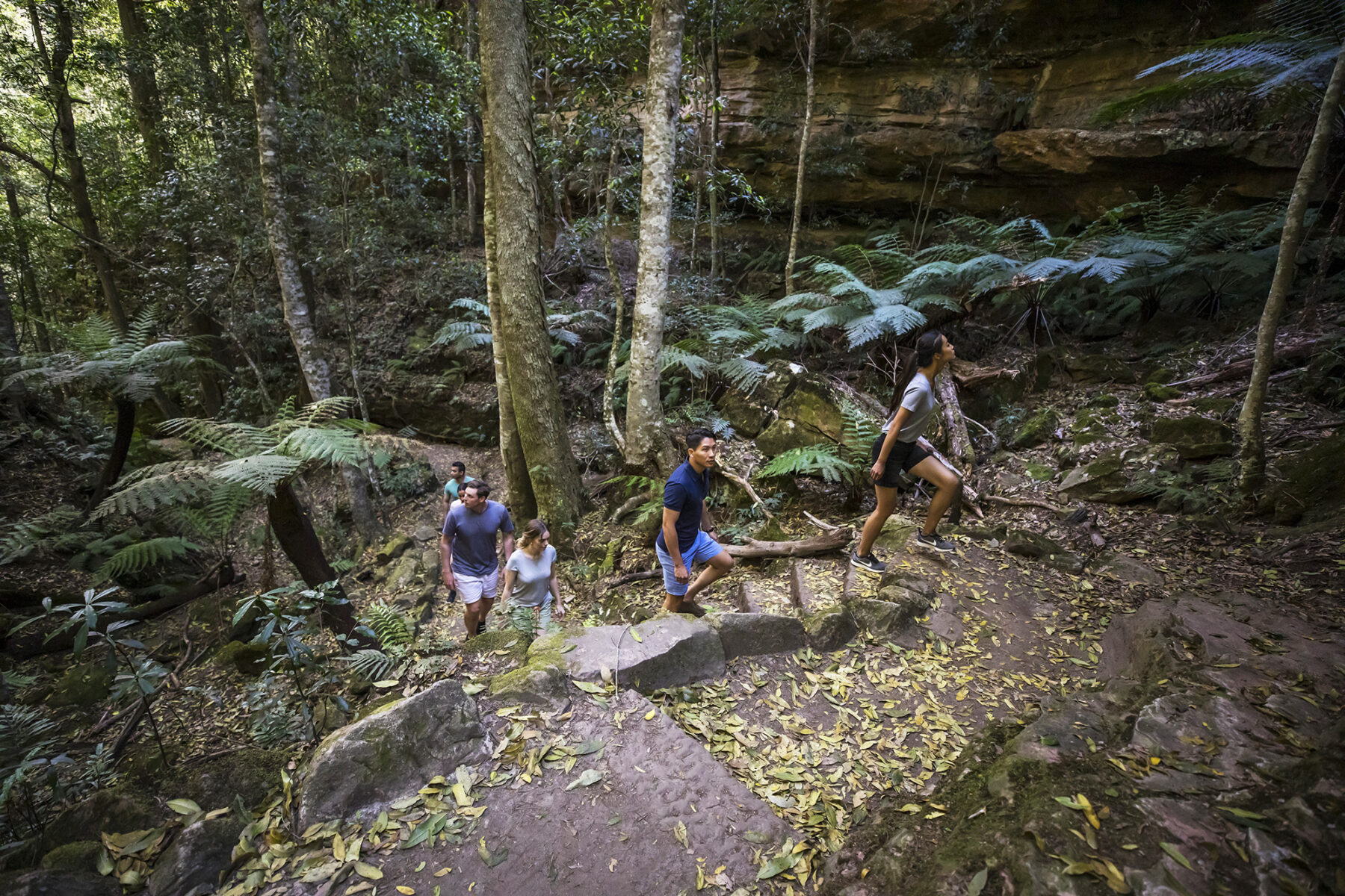
From the most westerly carpark the track zigzags downwards through open woodland, soon turning into damp forest. The vegetation is colourful and varied, with an abundance of waratahs in spring and flannel flowers in summer. Passing the ‘Rotunda’, a large overhang and Aboriginal occupation shelter, you’ll soon go through a completely enclosed tunnel, created many years ago by a rock fall. Emerging on the other side, you’ll pass under the spray of a waterfall. About 20 minutes after crossing a wooden bridge, the track meets Greaves Creek. It’s tranquil and sheltered here, and surprisingly cool even on the hottest of days. At the end of this stretch, there is a perfect swimming hole on your right. A couple of minutes further on you arrive at the Rodriguez Pass junction, leading to Beauchamp Falls. From this point the track ascends steeply to Evans Lookout, where there are views over the Grose Valley and across to Mt Banks and Mt Tomah. From here, follow the easy footpath back to the carparks.
Despite the name, the Blue Mountains aren’t really mountains at all. The entire area is one huge plateau dissected by gorges and waterways. The canyons are formed by water running down planes of weakness in the rock and further scoured when flash floods toss rocks and debris along the canyon walls. This walk can be busy on the weekend so aim for midweek if possible.
Breadknife and High Tops, NSW
Distance: 14.5km loop Time: 5–6 hours Difficulty: Medium
Warrumbungle National Park, situated about 35km west of Coonabarabran and some 140km northeast of Dubbo, is crisscrossed by sensational bushwalks, bursting with wildlife and dominated by a series of rugged volcanic outcrops. About 17-13 million years ago, a shield volcano in the Warrumbungle area oozed lava in thick plugs, cooling slowly to form the fine-grained trachyte we see today. The shield volcano has long since eroded away, but the plugs, dykes and cones remain. They are the distinctive features for which the Warrumbungles are known today, and they include the iconic 90m-high slice of jutting trachyte dubbed the Breadknife.

This walk is breathtaking in every way and makes for an incredibly satisfying day in the wilderness. Starting from Pincham carpark, the trail follows Spirey Creek then climbs steeply to Spirey View where you can see the Breadknife and Belougery Spire. Next, the path climbs away from the creek up into dry woodland, to reach Grand High Tops summit where you can take in a vista of the whole park, the Siding Spring Observatory to the east and Bluff Mountain to the west. From Dagda Gap this route heads west to Dows Camp (there is a 2.6km return side trip up Bluff Mountain here) before turning north towards Ogma Gap camp and West Spirey Track.
The range’s relatively high position (with peaks up to 1206m), temperature extremes and location on the border of NSW’s dry western plains and moister eastern ecosystems means it has a strange mix of more than 620 plant species, ranging from spinifex and sticky daisy bush to white gums and western golden wattles. In winter the temperature can drop to freezing overnight. The wildflowers are superb in spring – on this track you’re likely to see purple hoveas, white daisy bushes, yellow wattles, and orange pea flowers.
Coast Track, NSW
Distance: 9.7km Time: 5 hours Difficulty: Medium
The Coast Track is the jewel in the crown of Royal National Park, just south of Sydney. Stretching from Bundeena to Otford along the coastline, the track passes through several distinct landscapes: bare cliff-scapes south of Bundeena, wild moors between Wattamolla and Garie, open grassy slopes at South Era and North Era, and remnant rainforest and sheltered woodland between Burning Palms and Otford. The entire Coast Track is 28km, starting with a ferry from Cronulla and ending with a train from Otford back to Sydney. Very fit walkers can do it in a day or at a more leisurely pace in two, camping overnight at North Era, 8km from the start.
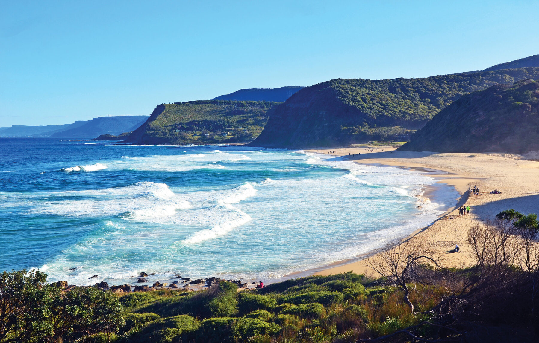
However, if you can manage a car shuffle the best section is this day walk from Garie Beach to Otford, for its golden beaches, heritage beach huts, grand ocean views and shady forest paths. The beach shacks of Bulgo, Burning Palms, South Era and Garie were built during the Depression, when ample seafood supplemented scarce diets. Still without mains electricity and accessible only on foot, these shacks are now preserved under the National Trust. Other highlights include a huge shell midden at North Era, perhaps as much as 8000 years old, swamp wallabies south of Burning Palms beach and a sublime stretch of forest known as Palm Jungle.
Namadgi Settlers Track, ACT
Distance: 9km circuit Time: 3–4 hours Difficulty: Easy
Namadgi was the name used by the local Aboriginal people for the mountain range south-west of Canberra. Gazetted in 1984, Namadgi National Park occupies almost half of the area of the ACT and encompasses spectacular views from its many mountain peaks. There are more than 160km of walking tracks in the park, but this one explores the cultural heritage of the Australian Alps with a look at the lives of late 19th-century settlers. This lovely loop walk meanders through forest, then open grassland and finally grassy woodland to see three pastoralists’ huts, restored by community group, Kosciuszko Huts Association (KHA), who have also researched the stories and photographs of the settlers, workers and their families seen on information boards along the walk.

William and Flora Brayshaw settled here in 1844 and Thomas and Mary Jane Westerman in 1882. Several generations were born and buried in this isolated and unforgiving landscape. The walk starts at Brayshaw’s Homestead, built in 1903 from timber slabs with a stone chimney. This rudimentary two-room cottage housed a bachelor for 28 years. It had no stove, just a camp oven, and it wasn’t until a family bought it in the 1930s that the walls were papered with newspaper to keep out icy draughts. The next hut, Waterhole, is even more rudimentary – built of corrugated iron in the 1930s to shelter stockmen who worked in the area, land-clearing and sheep drenching in the nearby stockyards. Westerman’s Homestead was built in 1916, the family’s third dwelling on this spot. There is a small graveyard and remnants of a garden with exotic trees.
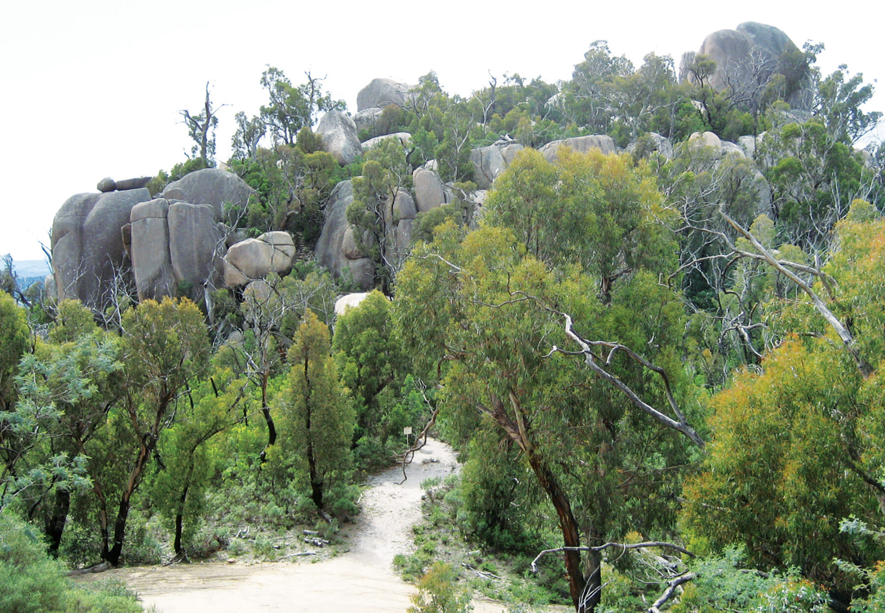
Gibraltar Peak, ACT
Distance: 8.2km return Time: 3–4 hours Difficulty: Medium
The big, grey, granite shapes of Gibraltar Peak (1038m) rise above Tidbinbilla Nature Reserve like the gently rounded backs of a herd of elephants. It’s not a dramatic peak but is nevertheless a satisfyingly stiff climb near the top and the flat summit is a wonderful place to linger over a picnic and some of the best views in the ACT.
Tidbinbilla, just to the south-west of Canberra, is a popular spot for a family barbecue among friendly kangaroos and emus, as well as more elusive koalas, brush-tailed rock-wallabies and echidnas. There’s a visitor centre, kiosk, and the fenced Tidbinbilla Sanctuary wetlands. The name of the reserve is thought to derive from the Ngunnawal word Jedbinbilla – a place where boys were made men, referring to initiation ceremonies.
The walk starts from Dalsetta carpark. About 500m from the start, look for an orange post that indicates left to Gibraltar Peak or straight ahead to the Xanthorrhoea Loop. If you have the energy at the start or end of your climb to the summit, it’s well worth the 1km detour here to see a magnificent stand of grasstrees (Xanthorrhoea australis). The track to the peak ascends gradually through open grassland, past relaxed mobs of kangaroos, to Eliza Saddle. From here it’s a steep climb up to a viewing platform and granite steps to the summit 800m further on. It’s possible to descend to the carpark via a fire trail but it’s a less interesting route.


