
The Grampians Peaks Trail
There’s nothing like an epic traverse for a big dose of challenge, an escape, and the thrill of discovery. The string of mountains that make up the Grampians (Gariwerd) have long made a favourite outdoor playground but the new 164km Grampians Peaks Trail (GPT) offers a deep dive into its spectacular and varied terrain. I headed out to walk it solo on the first day it opened. Here’s what I learned.
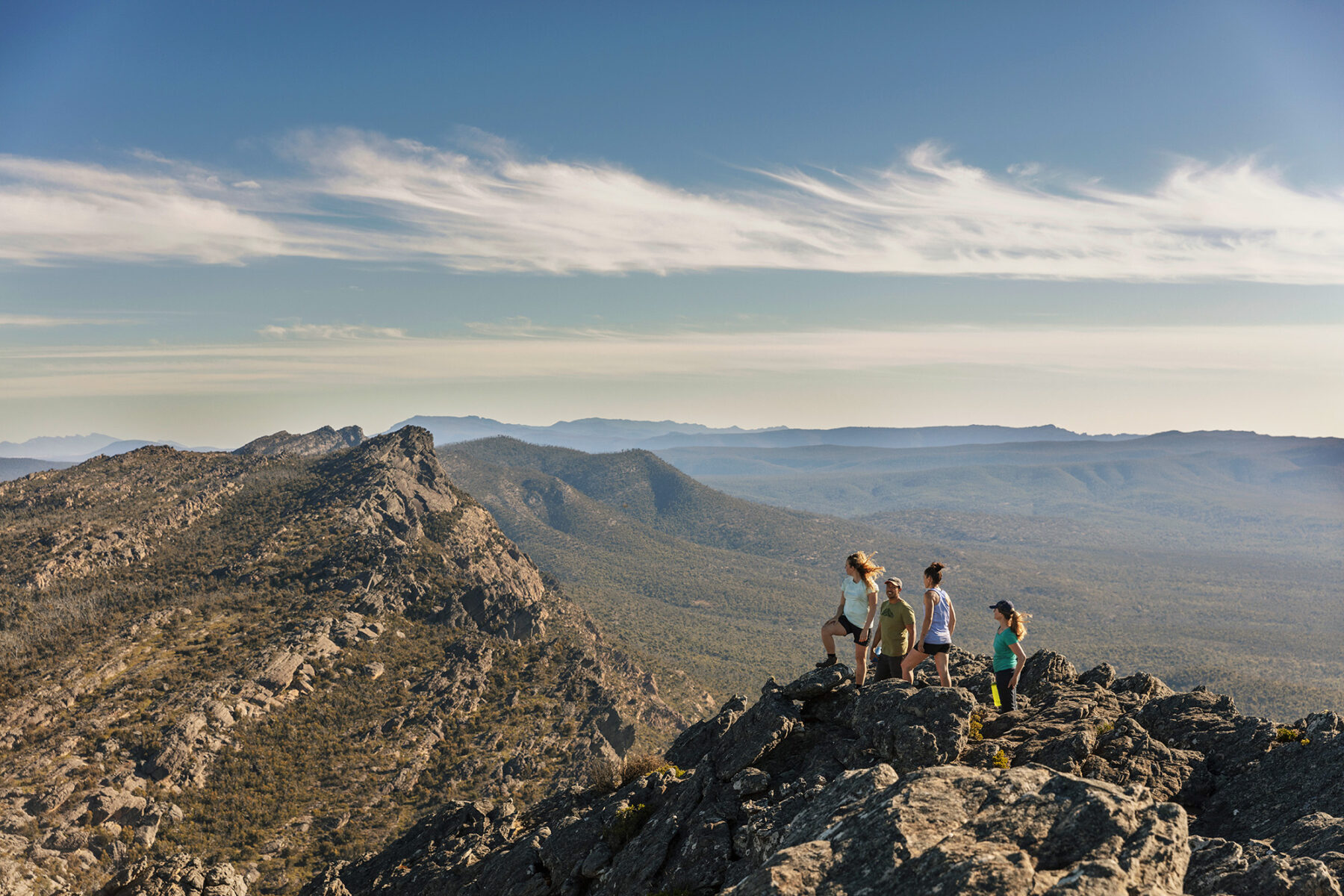
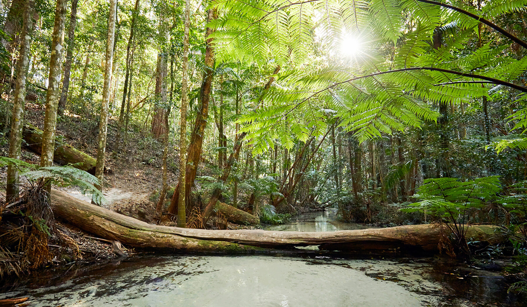
Excitement levels were high when I stood on top of Mt Zero at the trail’s northern end, contemplating the 13-day adventure ahead that would lead me to the little town of Dunkeld. Though well familiar with a few justly popular areas of the national park, I was about to see the ranges in their entirety, including 100km of new track. Formed from sandstone, the Grampians have been tilted and uplifted, creating a string of mountains with sheer cliffs on one side and sloping into the Wimmera Plains on the other. With the route drizzling over all its highest peaks, it’s regularly above the tree line making for a spectacular hike.
If you look at the daily distances on this trail (8-16km per day) you’d be forgiven for thinking it’s a cruisy ramble – at least that’s what I was did. I was wrong. For starters, you’re climbing nearly the height of Everest (elevation gain is over 8,000m) and the undulations feel relentless at times. I soon came to be audibly appreciating any flat ground I encountered, and though I was sure I’d packed far too many snacks, I shoveled in every calorie. Add in a few side trips to waterfalls or lookouts, and days might take longer than anticipated. Two kilometres an hour is about the average pace; my slowest day was eight hours for 13km – due not only to the 700 metres of climbing and getting distracted by views, but the terrain itself.
While there’s been a lot of talk about the fancy architecturally designed campsites, the track itself is another story. This is no cake walk (read this in flashing neon lights). Proper benched track is rare; more common are slabs of sloping rock, rock hopping and the odd scramble. Add water – like the rain and hail I copped on a few days – and things fast get slippery and slow.
Most of the trail is classified as Grade 4, with one Grade 5 section over the Seven Dials Escarpment to Redman Bluff. As a solo walker I was really challenged on a bit of this section that required me to remove my pack, drag it through a crack and up some boulders. For the most part, signage is pretty good but there are a few sections where you need to pay attention, thanks to the rocky terrain which gives no clues as to trafficked routes. It’s challenging, but these factors also make for an interesting and exciting walk.
The North, Central and South sections are all impressive in their own way; all undulate over the mountains, offering consistent great views. If you can only spare four days, the North offers a great snapshot of the Grampians with interesting rock-hopping, expansive views from high ridgelines, vast valleys, waterfalls and bracken fern-filled forest.
There’s a real sense of wildness in the Central section once you get past The Wonderland Range – the most famous and heavily visited part of the Grampians. After passing Mt William and the Major Mitchell Plateau, you’re far from day-trippers and the views here are some of the best, especially across to the long and serrated Serra Range running parallel. It’s also the toughest bit of the trail. The South is easiest and where most of the new trail is. Climbs are shorter, the trail is more defined, and inclines are made easier by stone steps. I passed more wildflowers and wildlife (kangaroos, echidnas, emus) in this section than others.
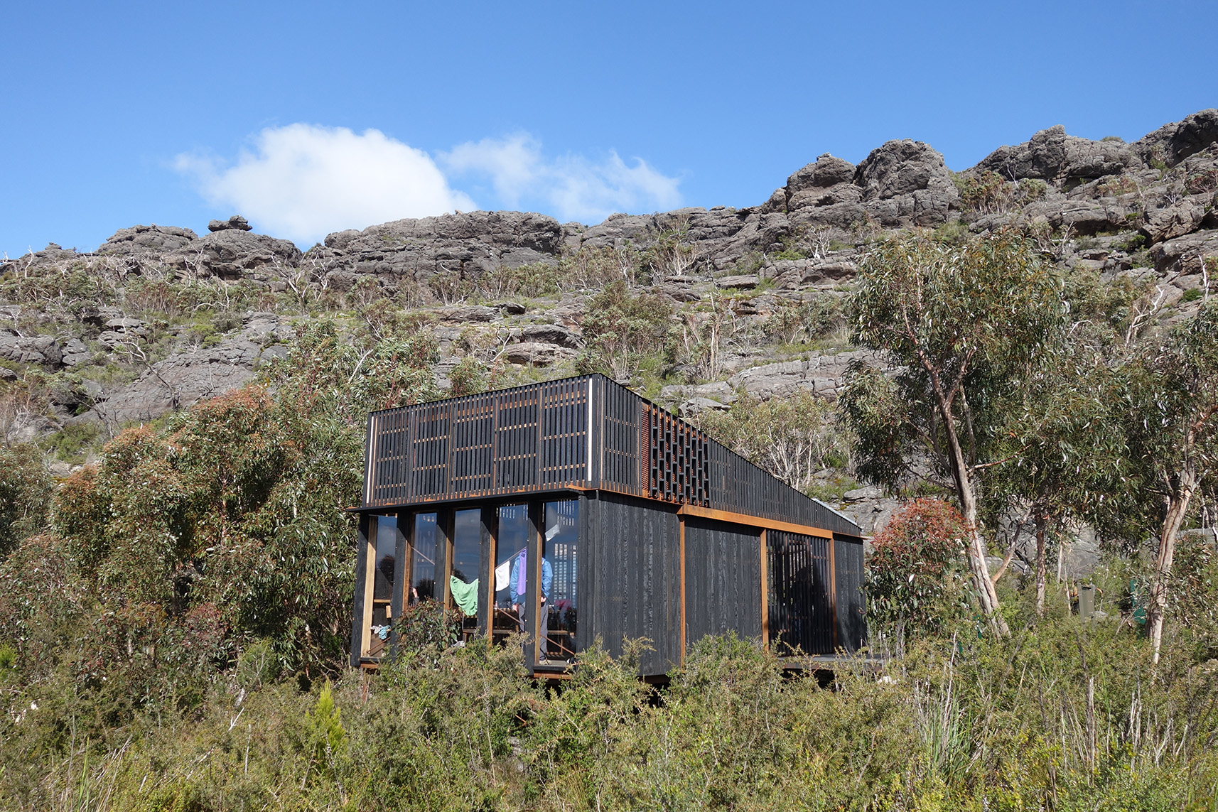
What really elevates this walk is the awesome campsites waiting at day’s end. Whatever the elements throw at you, it’s nice to have somewhere to retreat to and the GPT has super cool fully sealed communal shelters at all but three campsites (naturally they were the ones that, for me, coincided with 70kph winds and a mega thunder storm). They’re not for sleeping in – carry all the usual camping/cooking equipment – but they do have tables and bench seats, USB charging points, water tanks and usually an epic view. Tents are pitched on either timber platforms or packed-earth tent pads. Gar camp, in the northern section, is a standout, perched on the rim of a cliff along with a few wooden sun lounges. Both it and Werdug camp also have three cute little 4-bed huts, bookable only by guided walking companies.
I love a thru-hike but 13 days non-stop is a long time in this kind of terrain. If you want to break it up there are a multitude of access points enabling stints of one, two, three days and upwards. Campsites need to be booked through Parks Victoria and there’s no doubling up of sections in one day permitted. (Being the first guinea pig on the trail, I got an exemption to combine a couple of days and then regretted it deeply!)
It’s a one-way adventure so you’re looking at a car shuffle (1.5hrs each way), or enlisting the services of Grampians Peaks Walking Company, to move between trailheads. I also utilised its food drop service, so I didn’t have to carry more than four t- five days’ worth at once. One night is spent in the town of Halls Gap, convenient for a shower, a hearty feed, and a resupply.
With all that huffing and puffing you can really guzzle through some water and while tanks at campsites occasionally run low, there are additional ones sprinkled near road access points that are kept topped up.
The GPT promises a real adventure and is set to become an Aussie classic. – Laura Waters
Inca Rivers Trek, Peru
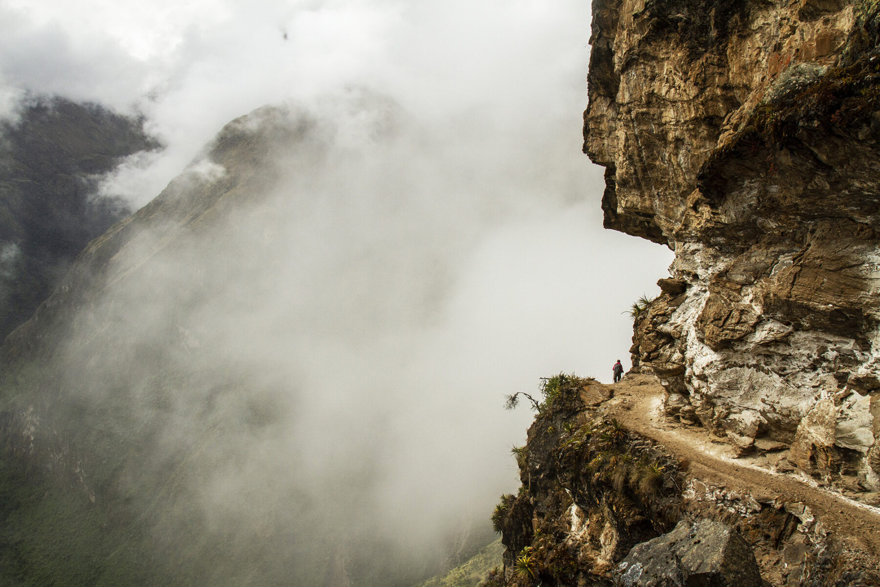
For those keen to avoid the crowds of the Inca Trail, while still enjoying some amazing Inca ruins and Peruvian history and culture, the nine-day, 104km Inca Rivers trek is a must-do. Starting at a heady 2600 metres at Cachora, the track soon heads further up – and then down; each day you can expect to ascend and then descend anywhere from 500 to 1000m in altitude – over the course of the nine days, before reaching the final destination of Macchu Picchu itself.
The track’s final destination is, of course, well worth the nine days’ effort, but it is the daily highlights of this trek that make it a worthy Top 10 inclusion. Most notably, on the third day, hikers reach the ruins of Choquequirao, estimated to be only 30 percent uncovered by archaeologists but, once fully cleared, it is claimed this site will be both more complete and larger than Macchu Picchu itself.
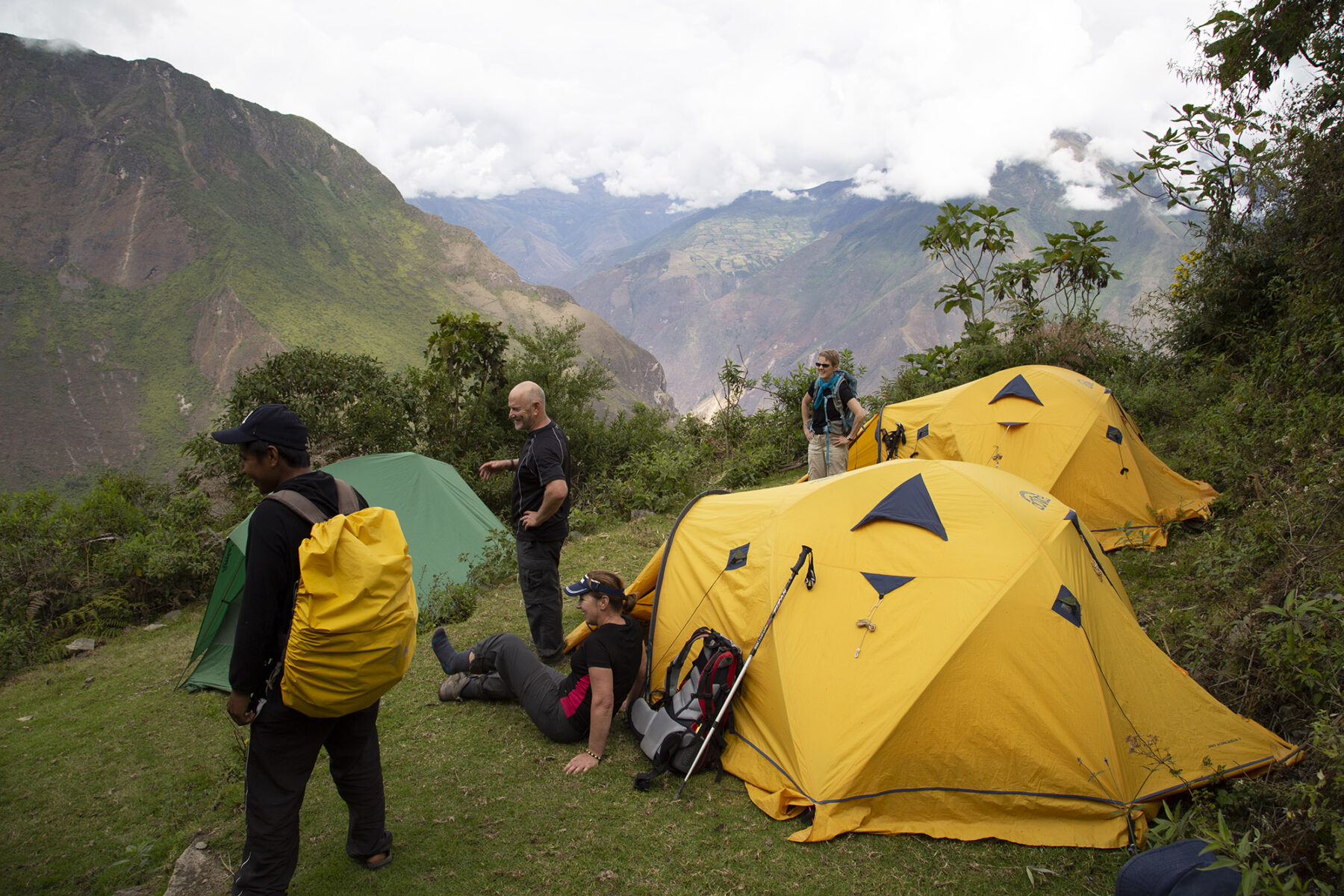
Other highlights over the nine days include first descending, then crossing and ascending, two massive river valleys – the Apurimac and the Rio Blanco, where you can camp by the river. The condor is prevalent in these high mountains so there’s a good chance of spotting both juveniles and adults soaring above on the thermal air currents. The reclusive spectacled bear makes its home here in the high peaks as well, as do jaguar at the lower elevations.
Due to its proximity to the equator, even at high altitudes (the trek reaches a high point of 4660m), the track is often shrouded in lush jungle and rainforest. The campsites along the way are near very small villages/settlements, and you’ll also become used to seeing Inca stonework daily along the track.
The Inca Rivers Trail can be walked independently, but the best option is to book a guided trek with an operator such as World Expeditions. The company includes the necessary amount of acclimatisation days pre-trek on their Inca River adventure, and the guides are exceptional in regard to both their experience at high-altitude trekking and knowledge of Peru’s culture and history.
The Inca Rivers Trail offers the best of all worlds: a final destination recognised as one of the world’s wonders; the relatively unknown, but amazing, archaeological discovery that is Choquequirao; the strong Peruvian culture; and the fact that you will rarely see anyone but your own group trekking the trail. – Justin Walker
Rafting the Colorado River, USA
It’s a true paddling icon. The mighty Colorado River winds its way through a number of US states over its 2330km length. One of the most popular rafting sections of this river is the 362km path it has cut through Arizona’s Grand Canyon. Other states, such as Utah, also offer some brilliant rafting on the Colorado River (more on these later).
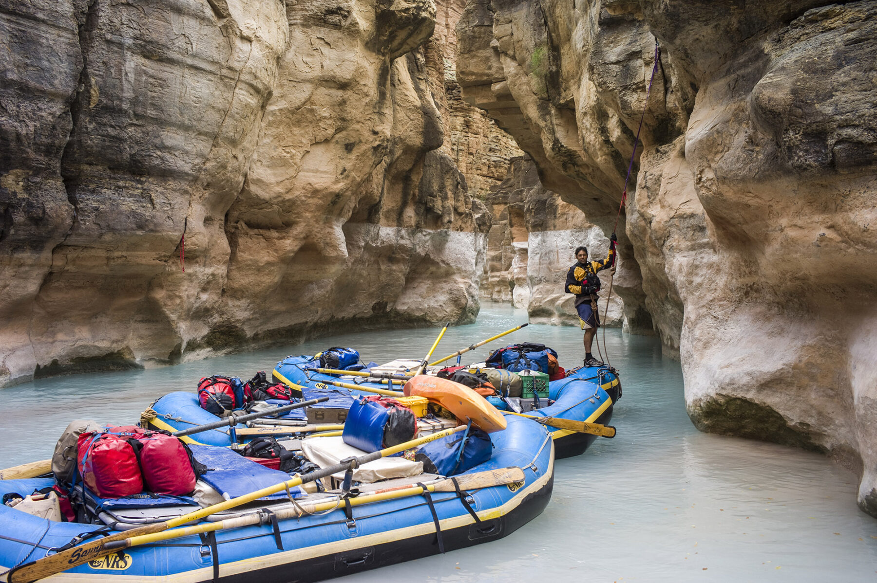
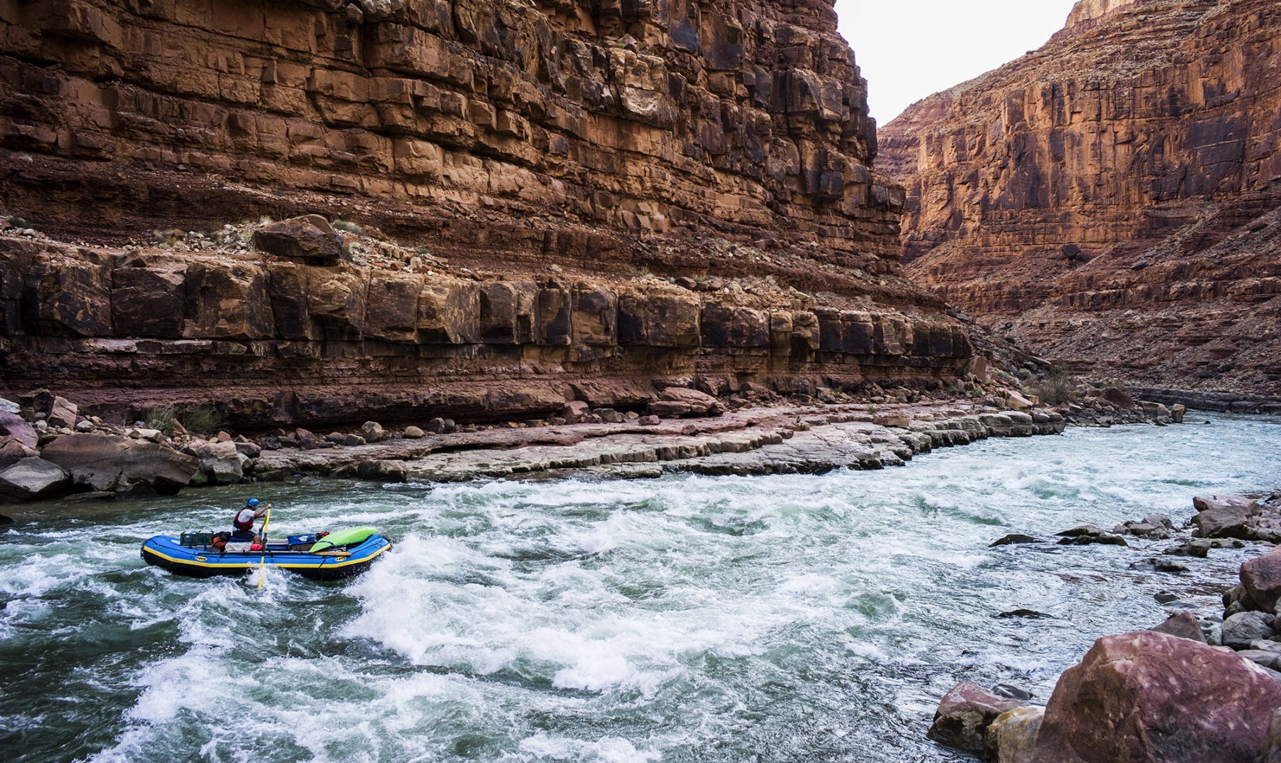
The Grand Canyon trip starts at Lees Ferry and – if you do the full 362km of this trip – finishes at Diamond Creek. Along the way, there are 42 sets of huge rapids to negotiate, ancient cliff walls hiding indigenous ruins to explore, numerous opportunities for day hikes and brilliant beach camping to experience.
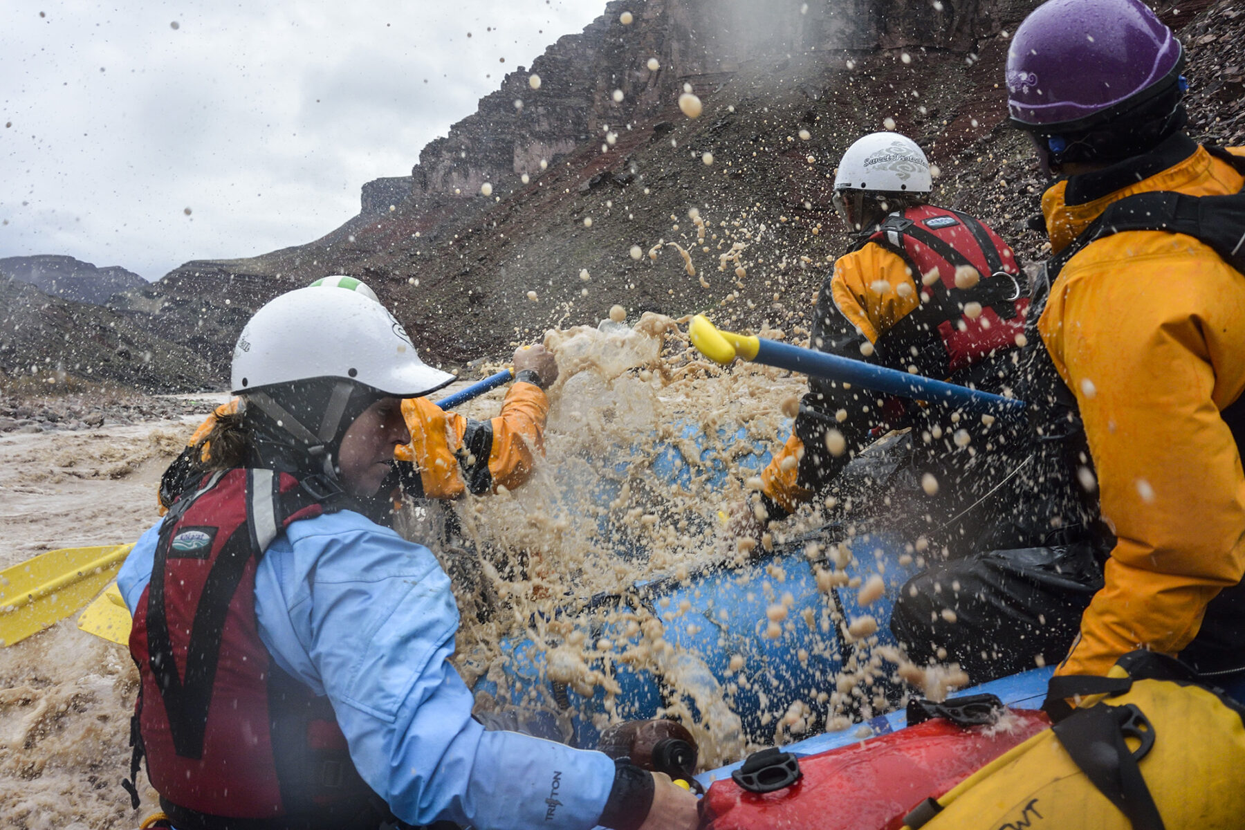
In short, for anyone who loves running rivers, the Colorado River is up near the top of their bucket list. To tackle it as an independent paddler (with a crew) can mean years of waiting for permits to become available, but there are around 16 companies that offer guided rafting trips down the river, and this can range from a one day literal ‘dip in the water’ taste of the Colorado, through to two-week (or a touch longer) expeditions. You have a wide range of choices when it comes to watercraft, too, with the big oar rafts popular (you don’t have to paddle on these) but also the option of a powered raft, a paddle raft (where you do have to paddle, along with four others and the guide) and – for us, anyway – the unforgettable experience of punching down this powerful river in a wooden dory, where all you have to do is hang on as an boatman steers you through.
Up to 24,000 people run the river each year, with half opting for the powered-raft option, due to time constraints and/or physical impediment. These big-boppers are only allowed on the river for around five months but due to the speed with which they travel the river, they do open up more side-trip options, in the form of hikes and exploration. Be aware that the water is very cold, not moving much above 8°C, so bring your warm/waterproof gear.
The journey begins with sections of rapids from the get-go, with the Marble Canyon section having slightly smaller rapids (rated between two and six; the rapids on the Colorado River are rated on a scale of 10, which differs from most other rivers globally), before they grow bigger and bigger, the further into the Grand Canyon you go.
If you haven’t got your heart set on the Grand Canyon section of the Colorado River, a brilliant option for rafters chasing a few days on the river is Utah’s Cataract Canyon. Claimed to offer the biggest spring run-off of whitewater, a three-day (guided) trip down this canyon is packed with a total of 22.5km of intense rapids, including the famous Big Drop and Satan’s Gut, among others. This Colorado River experience has a memorable start, with a jetboat trip downriver before swapping over to rafts at The Confluence, where the Green River meets the Colorado, just south of Utah’s adventure capital of Moab. The result is loads of Class III-V rapids as the river rolls through Canyonlands National Park. Beautiful rock formations and more fabulous beach camping are a feature of this trip along with – again – a number of side-trips to archaeological sites.
A full- or two-day challenge for more experienced rafters (you can go guided or unguided) is Westwater Canyon, in Utah. Often compared to the Grand Canyon, this trip takes rafters through the narrow walls of Black Granite Gorge and through 11 Class III-IV rapids, including the aptly-named Sock-It-To-Me and Last Chance. This trip has a nice mix of flatwater and rapids as well as the chance to check out historic buildings, such as miner’s cabins, and ancient petroglyphs as well. Even though a one-day trip is possible, we’d recommend two days on this part of the Colorado River, just to make the most of where you are; it is, after all, one of the world’s greatest outdoor escapes!
And don’t think the Colorado River is only limited to adults: a popular stretch of the river (just north of Moab) can be rafted as a half- or full-day adventure and its rapids are limited to Class I and Class II – ideal for kids and families to enjoy this famous waterway. – Justin Walker
Island escape: Kingfisher Bay Resort, K’gari
It is the world’s largest sand island, and one that contains a number of simply spectacular sights – and outdoor experiences. Best of all, K’gari (Fraser Island) is easily accessible to adventurous travellers, keen to explore this renowned natural wonder. To make that exploration more enjoyable, base yourself at Kingfisher Bay Resort and utilise this as your island basecamp from which to enjoy its many ranger-guided activities and island tours available each day. These tours range from single to multi-day and are operated by K’gari Explorer Tours. These brilliant experriences allow you to discover a number of the island’s highlights while enjoying a stay at the resort.
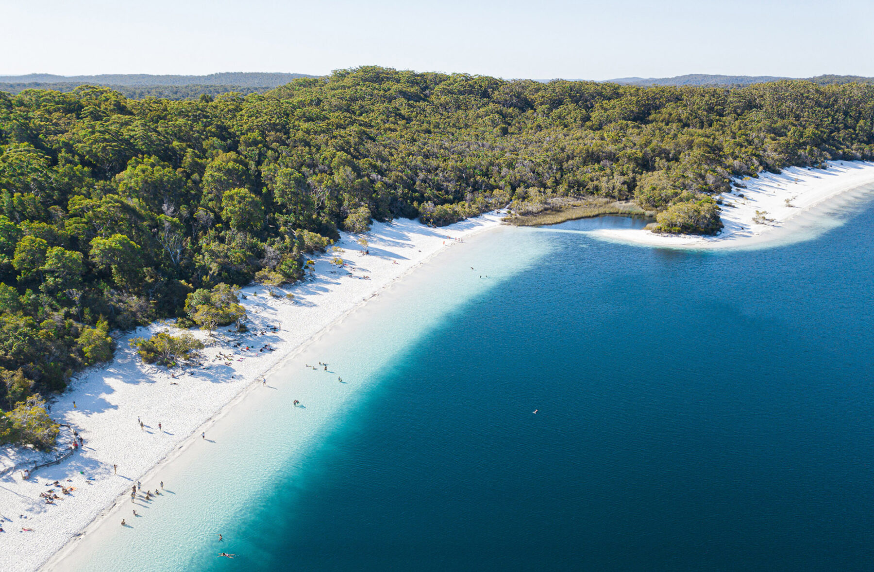
Lake McKenzie (Boorangoora), in the heart of the island, is its most popular natural site, and a brilliant family escape on the island – and it is easy to see why, with this freshwater lake sitting 100 metres above sea level, and receiving its water from the clouds, rather than the surrounding ocean. Its temperate water also means you can swim all year round.
For the vehicle-borne island explorers, there is pristine 75 Mile Beach (a gazetted highway) which provides great driving along the eastern coastline. While you’re watching the fishing folks cast for their meals in the sea, keep an eye above; this beach is also one of only two locations around the world where planes are allowed to take off and land.
A historic landmark of a different kind along this beach is the wreck of the SS Maheno. Built in 1905 and once used as a Trans-Tasman liner, it was later commissioned for work as a hospital ship during World War I. So how did it end up on K’gari? Well, in 1935 it was run aground during a cyclone and has, since then, become an integral part of K’gari’s age-old, with the hull a nice stop-over on the drive along 75 Mile Beach.
For a more immersive escape, Eli Creek is a must-visit. Located on the island’s eastern beach (it is the largest creek at that location), you will witness an estimated four million litres of freshwater flowing into the ocean each hour. Not only is it worth just sitting on the sand and watching nature work its magic, but you can also float down this creek, passing pandanus trees crowding its banks, before either chilling out on the beach, or exploring further via the nearby boardwalk. Also found on the eastern beach are the Pinnacles Coloured Sands. With more than 72 shades of yellows, oranges and reds (thanks to the sand and clay’s iron-dense minerals), these formations are best visited at sunrise, which lights up the cliff faces, revealing a rich display of natural colours.
Central Station, in the island’s centre, is a significant Indigenous cultural site and home to a rich diversity of plant life, including satinay trees (once logged and actually used to rebuild London’s Docklands after World War II, owing to that timber from those trees being some of the world’s most hardy), along with kauri pine, oodles of ferns, and much more. This part of the island is protected under the Commonwealth Canopy Initiative.
We love camping but enjoying more relaxation and comfort by returning after a day out to your accommodation at Kingfisher Bay Resort makes staying here a no-brainer. Its location is spectacular, and with the all-inclusive packages – plus the knowledge you garner from its ranger-led tours – it qualifies as one of the ultimate island escapes.
Family escape: Kakadu National Park, NT
Kakadu NP: southern
Ignore the grumblings of “Kakadu, Kaka-don’t”; this globally famous 20,000-square-kilometre national park can fill half a year’s worth of adventures – and you’ll need all that time to do this huge world wonder some kind of justice.
Our northern Kakadu adventure kicks off with a leisurely 1.5-hour run from Darwin via the Arnhem Highway before you reach the park entrance. The temptation here is to punch through to the main tourist hub of Jabiru in the park, but to do so means you’ll miss one of Kakadu’s less visited highlights: the Waldak Irrmbal (West Alligator Head) track heads north to Pococks Beach, located on the park’s northern coastline, abutting Van Diemen Gulf. This drive is a cracker and if you have a spare day, with two waterholes – Two Mile Hole and Four Mile Hole – worth checking out.
To the heads
Four Mile Hole is great for fishing and is reached after backtracking four kilometres south from Two Mile to the Two Mile/Four Mile junction. Four Mile is, itself, reached via another junction; turning left and driving for about 15 minutes will see you at the Four Mile camping area, which has no facilities so if you’re looking to doss down here, be prepared. Returning to the main Waldak Irrmbal track and continuing north for a further 50km is challenging in parts but a great experience overall; the near-flat Manassi Floodplain that dominates this part of the park is only occasionally interrupted by stands of savannah forest, which increases in density (and is joined by huge palms) as you near Waldak Irrmbal and Pococks Beach itself. The facilities at Waldak Irrmbal are relatively basic but both Jungle Camp and Pococks Beach campsite offer a far more remote camping experience than you’ll find at one of Kakadu’s more easily accessed (and thus popular) campsites. You can explore Pococks Beach (be croc-aware; saltwater crocs often bask on the beach here) by foot and be sure to explore east of the campsites as well; the rocky outcrops and mangroves near the mouth of the West Alligator River are full of things to check out. It’s also worth keeping an eye out for the native orange-footed scrub fowl – or easier – its nest; this ground dwelling bird builds what is more appropriately dubbed a huge mound (they can be up to 4.5m tall and 9m in diameter) that is quite a sight.

Take the shortcut
The next day is the 80km return south via Waldak Irrmbal track, before reaching the Arnhem Highway and turning left. However, instead of following the highway all the way to Jabiru, follow it until you see a signposted 4X4-only track that leads south. This is a great ‘shortcut’ that, again, takes you away from the heaving dry season crowds on the bitumen roads and passes by some beautiful waterholes – Bucket, Alligator and Red Lily billabongs – before you ford the southern ‘tail’ of the Alligator River and join Old Jim Jim Road, another 4X4-only route.
Cruising and culture
Eventually, and a bit sadly, you will have to rejoin the bitumen at the Kakadu Highway, the park’s other main thoroughfare. For this second night, we’d highly recommend camping at Yellow Water (located slightly north just after you rejoin the Kakadu Highway) and partaking in the next morning’s sunrise cruise on this huge waterhole; birdlife, saltwater crocs and turtles can all be easily seen here. For the final day, you can then continue north back along the Kakadu Highway to the Nourlangie turn-off. Nourlangie contains some brilliant rock art and some short walks that take you to all the main sites. Next stop is Jabiru for the excellent cultural centre before (hopefully) timing your drive right and reaching Ubirr – another globally lauded rock-art site – where, after perusing the eons-old artwork, you walk to a vantage point that looks over the park’s northern floodplains for sunset. It’s brilliant.
Kakadu NP: southern section
This southern adventure in our famous national park begins with a straight bitumen run down the Stuart Highway to Pine Creek, and then turning left and following the Kakadu Highway into the park itself. Just inside the southern border is the excellent Goymarr Tourist Park. Tracking north from here you soon reach the turn-off to one of Kakadu’s most famous waterfalls – Gunlom. Unfortunately, this beautiful part of Kakadu NP is, at the time of writing, closed to visitors. Fingers crossed it will open again in the future as it is truly one of the national park’s jewels.
Going remote
For that remote bush camping experience in this busy park, we’d suggest driving further south-east to Jarrangbarnmi Campground (Koolpin Gorge). This campsite requires a permit (be sure to book well ahead; it can book out a year in advance) but the effort is worthwhile as it is simply sublime; the campsites are nestled beside Koolpin Creek and short walks (2km return) take you to remote plunge pools and waterfalls. It will be hard to return to camp…
Leaving this heaven-on-earth behind the next day, you will backtrack to the Kakadu Highway and continue north to the turn-off to the 4X4-only track to Maguk (Barramundi Gorge). This is yet another beautiful location – some short walks take you to one of the park’s best swimming holes.

A one-kilometre level walk from camp sees you reach a beautiful long plunge pool, with the waterfall at its eastern end (and easily reached by swimming). There’s also a separate walking track that takes you directly to the top of the waterfall itself where you can take a dip in the plunge pools above the falls themselves. From Maguk, it’s a short return to the highway and then a further drive north to the Graveside Gorge turn-off. This (very) remote campsite needs to be booked ahead and the drive in will take around three hours along the 44km of rocky, tricky terrain. It’s worth it of course if you wish to see another spectacular part of the park.
A fitting finish to the great escape
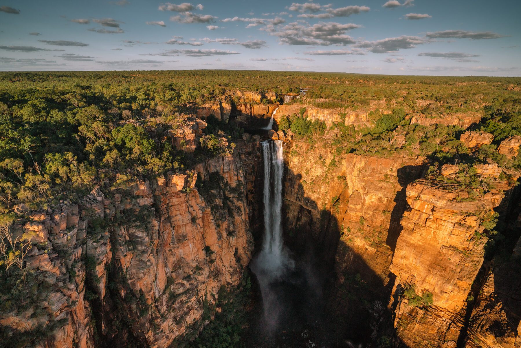
Further north from here – and, again, back on the Kakadu Highway for access – is Jim Jim Falls, one of Kakadu’s most famous visitor destinations. The drive in here is 4X4-only and is slow-going until you reach Garamarr campground. This campground is sizeable (it can handle 200 people) and has excellent facilities. From here, the access track to Jim Falls (and its beautiful plunge pool) continues, and you can also turn right to tackle the extra 10km to pretty Twin Falls too (there’s a water crossing here – a snorkel is advised for your vehicle) Twin Falls Gorge is accessed via a boat shuttle these days (you used to be able to float in there with a lilo) but as with everything in this park, it’s well worth the time and effort. For both Jim Jim and Twin Falls you can also gain access to the plateau above them, but both are steep and challenging walks (four hours for Twin Falls; six hours for Jim Jim). Speaking of which, the many walks in this area take you to some fantastic locations and it makes a fitting final night in Kakadu National Park.
Equally fitting is the last day’s journey out of the park. Rather than taking the bitumen Kakadu and Arnhem highways, we’d recommend backtracking south slightly from Jim Jim Falls and taking the 4X4-only Old Jim Jim Road as this tracks west through some fantastic floodplains and waterways and is, again, less crowded with visitors and vehicles. There is plenty of wildlife to spot along this route, as well.
A great morning tea/lunch spot is Giyamungkurr (Black Jungle Springs) camping area. From here it’s a straightforward run northwest to the Arnhem Highway and, after a few days in what seems like a totally untamed land, a return to ‘civilisation’.


