
Grampians Peaks Trail, VIC
There’s nothing like an epic traverse for a big dose of challenge and the thrill of discovery. The string of mountains that make up the Grampians (Gariwerd) have long made a favourite outdoor playground but the new 164km Grampians Peaks Trail (GPT) offers a deep dive into its spectacular and varied terrain. I headed out to walk it solo on the first day it opened. Here’s what I learned about one of Australia’s newest treks.
Excitement levels were high when I stood on top of Mt Zero at the trail’s northern end, contemplating the 13-day adventure ahead that would lead me to the little town of Dunkeld. Though well familiar with a few justly popular areas of the national park, I was about to see the ranges in their entirety, including 100km of new track. Formed from sandstone, the Grampians have been tilted and uplifted, creating a string of mountains with sheer cliffs on one side and sloping into the Wimmera Plains on the other. With the route drizzling over all its highest peaks, it’s regularly above the tree line making for a spectacular hike.

If you look at the daily distances on this trail (8-16km per day) you’d be forgiven for thinking it’s a cruisy ramble – at least that’s what I was did. I was wrong. For starters, you’re climbing nearly the height of Everest (elevation gain is over 8,000m) and the undulations feel relentless at times. I soon came to be audibly appreciating any flat ground I encountered, and though I was sure I’d packed far too many snacks, I shoveled in every calorie. Add in a few side trips to waterfalls or lookouts, and days might take longer than anticipated. Two kilometres an hour is about the average pace; my slowest day was eight hours for 13km – due not only to the 700 metres of climbing and getting distracted by views, but the terrain itself.
While there’s been a lot of talk about the fancy architecturally designed campsites, the track itself is another story. This is no cake walk (read this in flashing neon lights). Proper benched track is rare; more common are slabs of sloping rock, rock hopping and the odd scramble. Add water – like the rain and hail I copped on a few days – and things fast get slippery and slow.
Most of the trail is classified as Grade 4, with one Grade 5 section over the Seven Dials Escarpment to Redman Bluff. As a solo walker I was really challenged on a bit of this section that required me to remove my pack, drag it through a crack and up some boulders. For the most part, signage is pretty good but there are a few sections where you need to pay attention, thanks to the rocky terrain which gives no clues as to trafficked routes. It’s challenging, but these factors also make for an interesting and exciting walk.
The North, Central and South sections are all impressive in their own way; all undulate over the mountains, offering consistent great views. If you can only spare four days, the North offers a great snapshot of the Grampians with interesting rock-hopping, expansive views from high ridgelines, vast valleys, waterfalls and bracken fern-filled forest. There’s a real sense of wildness in the Central section once you get past The Wonderland Range – the most famous and heavily visited part of the Grampians. After passing Mt William and the Major Mitchell Plateau, you’re far from day-trippers and the views here are some of the best, especially across to the long and serrated Serra Range running parallel. It’s also the toughest bit of the trail. The South is easiest and where most of the new trail is. Climbs are shorter, the trail is more defined, and inclines are made easier by stone steps. I passed more wildflowers and wildlife (kangaroos, echidnas, emus) in this section than others.
What really elevates this walk is the awesome campsites waiting at day’s end. Whatever the elements throw at you, it’s nice to have somewhere to retreat to and the GPT has super cool fully sealed communal shelters at all but three campsites (naturally they were the ones that, for me, coincided with 70kph winds and a mega thunder storm). They’re not for sleeping in – carry all the usual camping/cooking equipment – but they do have tables and bench seats, USB charging points, water tanks and usually an epic view. Tents are pitched on either timber platforms or packed-earth tent pads. Gar camp, in the northern section, is a standout, perched on the rim of a cliff along with a few wooden sun lounges. Both it and Werdug camp also have three cute little 4-bed huts, bookable only by guided walking companies.
I love a thru-hike but 13 days non-stop is a long time in this kind of terrain. If you want to break it up there are a multitude of access points enabling stints of 1, 2, 3 days and upwards. Campsites need to be booked through Parks Victoria ($47 per site per night) and there’s no doubling up of sections in one day permitted. (Being the first guinea pig on the trail, I got an exemption to combine a couple of days and then regretted it deeply!)
It’s a one-way adventure so you’re looking at a car shuffle (1.5hrs each way), or enlisting the services of Grampians Peaks Walking Company, to move between trailheads. I also utilised its food drop service, so I didn’t have to carry more than 4-5 days’ worth at once. One night is spent in the town of Halls Gap, convenient for a shower, a hearty feed, and a resupply.
With all that huffing and puffing you can really guzzle through some water and while tanks at campsites occasionally run low, there are additional ones sprinkled near road access points that are kept topped up. The GPT promises a real adventure and is set to become an Aussie classic. – Laura Waters
Walls of Jerusalem National Park, TAS
This amazing national park sits in Tassie’s wild and remote southwest and is the Apple Isle’s only alpine national park. “The Walls”, as it is colloquially known, offers a number of trekking options, from day-hikes, to overnighters, through to seven-day circuits that take you deep into the national park’s southern section, with the opportunity to ascend a number of peaks.

For those with limited time, a day-walk (7-8 hours return) up toward the national parks’ campground at Wild Dog Creek, traversing dense native forest (passing an old trapper’s hut in this section) before reaching the Central Plateau and then on to the campground. From here, you ascend for another half-hour and pass through the Golden Gate to reach the beautiful Damascus Vale (the ideal lunch stop), where the park’s namesake cliffs tower over you. The descent back to the track-head is quicker, meaning you have the perfect excuse to stop off at Mole Creek Hotel for a coldie (and dinner) to celebrate.
For the super-keen hikers, a full six days in Walls of Jerusalem NP is a must. There are a few ways to do a circuit walk through here, so it’s worth consulting a map of the park or, if you’d rather, opt for a guided trek, such as the Walls of Jerusalem Circuit offered by Tasmanian Expeditions. This takes away the logistical hassles and allows you to soak up this magnificent part of Tassie over seven days. During that time, you’ll camp in some absolutely magic locations (including beside a couple of lakes), ascend a number of the mountains in the park, such as Mt Jerusalem and the West Wall Traverse, and traverse what is claimed to be one of the world’s best examples of a glacial valley (the Adelaide Valley).
Other Walls of Jerusalem hiking highlights include the section through Damascus Vale where you are dwarfed by the West Walls, and also the chance for a side-trip (conditions permitting) up on to the Mt Ragoona Plateau, where you can score views right across southwest Tassie to Cradle Mountain. It’s a busy six days – and you will need a decent level of multiday trek fitness – but you’ll be well rewarded. Walking “The Walls” is close to a full week of wonder, that’s for sure.
Mt Kenya, Kenya
Sitting in the shadow of Mt Kilimanjaro, Mt Kenya is the African continent’s second highest mountain, but to view the week-long journey up to its peak as “easier” would be doing it a huge disservice. Put simply, it is a cracking multiday trekking adventure, with a mix of route options to the top of the trekking summit of Point Lenana, along which you will encounter some seriously dramatic landscape and plenty of wildlife. Plus, there are far fewer hikers here compared to Kili…
Mt Kenya is best tackled in a guided group as this takes away all the hassles of logistics and permits (read about our guided trek up Mt Kenya, here). The adventure starts well before the walk; you will be transported via 4WD along a rough, slippery, bumpy track for a few hours before you start the track and walk to the cottages near the Chogoria gate entrance to Mt Kenya National Park. At this very early stage, you are already 3017m above sea level, so the rest of the afternoon is spent relaxing in the cottages and getting ready for your next day of walking.

The first day is through forest before moving higher and into an alpine moorland region. Keep an eye out for wildlife ranging from elephant and buffalo to antelope and monkeys along the way to camp at Lake Ellis. This is a beautiful first camp but is trumped by the campsite at Lake Michaelson on the second night. After climbing high up to 4000m, you suddenly drop down 200m into the famous Gorges Valley, a part of which encompasses the campsite itself.
The landscape changes again the following day as you trek even higher; moorland grasses drop away as you enter the high alpine zone and are replaced by rock and scree, with the jagged spires of the nearby peaks adding to the lunar-esque terrain. From high camp at Simba Tarn (a lofty 4560m) the final push – via an early 3.30am start – will take you to the summit of Point Lenana (4985m), with 360-degree views of the plains below and, amazingly, the dome-shaped silhouette of Mt Kilimanjaro, roughly 260km in the distance. Mt Kenya is made up of three separate peaks, with Lenana the highest trekking summit. For those with climbing skills (and more time) the pyramid-shaped Batian is the true high peak of Mt Kenya, and a serious alpine/rock climbing goal.
The return from the summit is long but downhill; passing Shipton’s Camp, with its buildings and other trek groups camped around them, you will make your way down to Moses Camp for a well-earned rest before the last descent down the Sirimon Valley to the national park gate. For a five-day trek, Mt Kenya packs in everything you could wish for: wildlife, amazing scenery, great guides and porters, and what rates as one of the world’s most amazing sunrises.
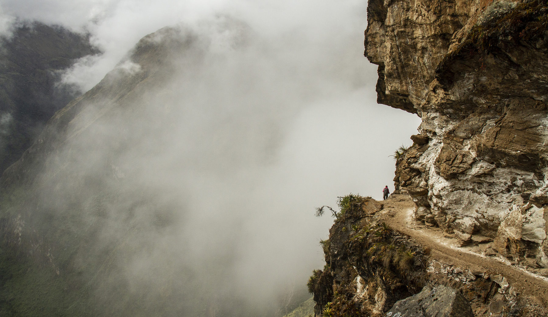
Inca Rivers Trek, Peru
For those keen to avoid the crowds of the Inca Trail, while still enjoying some amazing Inca ruins and Peruvian history and culture, the nine-day, 104km Inca Rivers trek is perfect. Starting at a heady 2600 metres at Cachora, the track soon continues higher – and then down; each day you can expect to ascend and then descend anywhere from 500m to 1000m in altitude – over the course of the nine days, before reaching the final destination of Macchu Picchu itself.
The track’s final destination is, of course, well worth the nine days’ effort, but it is the daily highlights of this trek that make it a worthy inclusion in this list. Most notably, on the third day, hikers reach the ruins of Choquequirao, estimated to be only 30 per cent uncovered by archaeologists but, once fully cleared, it is claimed this site will be both more complete and larger than Macchu Picchu itself.
Other highlights over the nine days include first descending, then crossing and ascending, two massive river valleys – the Apurimac and the Rio Blanco – where you can camp by the river. The condor is prevalent in these high mountains so there’s a good chance of spotting juveniles and adults soaring above on the thermal air currents. The reclusive spectacled bear makes its home here in the high peaks as well, as do jaguar at lower elevations.
Due to its proximity to the equator, even at high altitudes (the trek reaches a high point of 4660m), the track is often shrouded in lush jungle and rainforest. The campsites along the way are near very small villages/settlements, and you’ll also become used to seeing Inca stonework daily along the track.
The Inca Rivers Trail can be walked independently, but the best option is to book a guided trek with an operator such as World Expeditions. The company includes the necessary amount of acclimatisation days pre-trek on their Inca River adventure, and the guides are exceptional in regard to both their experience at high-altitude trekking and knowledge of Peru’s culture and history.
The Inca Rivers Trail offers the best of all worlds: a final destination recognised as one of the world’s wonders; the relatively unknown, but amazing, archaeological discovery that is Choquequirao; the strong Peruvian culture; and the fact that you will rarely see anyone but your own group on this trail.
The Great Himalaya Trail
Yep, there’s little doubt that the Great Himalaya Trail (GHT) – all 1700km and 152 days of it – is the Big One of multi-day treks. There are other uber-long distance treks – the Appalachian and Pacific Crest trails in the USA are just two to mind – but the GHT offers probably the most complete experience when it comes to not only trekking itself, but in terms of the variety of terrain you traverse, and the myriad cultural experiences along the way as you cross Nepal’s mountainous spine.
The appeal of doing the “full GHT” is obvious, but for those with less time, the fact that the GHT can be walked in sections as well, ups its appeal considerably. You can do the full-length GHT and the various sections independently, but for those who like most of the planning and logistics taken care of, Aussie adventure travel experts World Expeditions offer both the full monty traverse and the choice to do one, two, three or – eventually – all seven of the GHT sections.

For those (mad?) keen to do the full GHT in one hit, experience and preparation are crucial – as is the ability to pay for it (it sure ain’t cheap) and have an employer who, hopefully, understands your dreams and will allow you to take off what is nearly half a year from you job. Get all those variables to align and you are off on one of the world’s biggest trekking adventures.
The highlights are myriad on this journey – getting up close to Nepal’s high peaks, walking in terrain ranging from humid lowlands to snow-draped alpine areas, and the multiple cultural experiences from each region are just a few – as is the personal satisfaction of simply completing such an adventure. The GHT experience offered by World Expeditions starts in the east of Nepal, in the Kanchenjunga region, and ends in the west at the border with Tibet, in the town of Hilsa.
If time is an issue, then one or more of the seven separate sections in no way lessens either the challenge or the appeal (and it is a lot more feasible budget-wise). In fact, spending seven separate years joining up sections of one of the world’s best treks isn’t a bad way to spend your time!