The adventure wonderland that is the Yukon Territory is one of Canada’s northernmost territories – and it is massive. At 482,443 square kilometres, the Yukon contains a diverse mix of landscapes, from mountain ranges and glaciers, to huge lakes, immense valleys, and a number of wild waterways (including the territory’s namesake river).
The Yukon is 80 per cent wilderness, which means an abundance of wildlife, such as grizzly bears, wolves, moose, caribou, bald eagles and more. The sparse population of around 41,800 residents equates to a wilderness-to-people ratio of 0.1 person per square kilometre, with its capital, Whitehorse, one of the world’s great adventure towns. So, yeah, there’s a huge amount of space; something I remind myself of as I fly in a helicopter over mountain ranges east of Dawson City, toward one of the Yukon’s iconic outdoor playgrounds. This is the first of eight days of trying to experience as much of the Yukon’s lengthy menu of outdoor activities and is already shaping up as nearly a mission impossible. But I can’t say I am not going to try…
NORTHERN EXPOSURE
The thrum of the helicopter’s blades disappear as my full attention is diverted to what is unfolding below me – a not so subtle reminder of the Yukon Territory’s grandeur. The TransNorth chopper is inching slowly through the air toward the jagged, knife-edged silhouette of Tombstone Mountain, and I have a literal front-row seat; the cockpit glass curves in front and then underneath my feet and that dramatic peak seems within toe-touching distance. Flying through a lower gap in the Tombstone Range’s spires is a breathtaking, memorable way to be introduced to one of the Yukon Territory’s natural wonders: Tombstone Territorial Park. Along with The Klondike Experience guide, Kevin Desperrier, I am here for three days of trekking and camping, exploring this park’s natural highlights, far removed from the hustle and bustle of ‘regular’ life. It is a chance to reconnect with this planet’s wild side, and I couldn’t have picked a more perfect locale for that purpose.
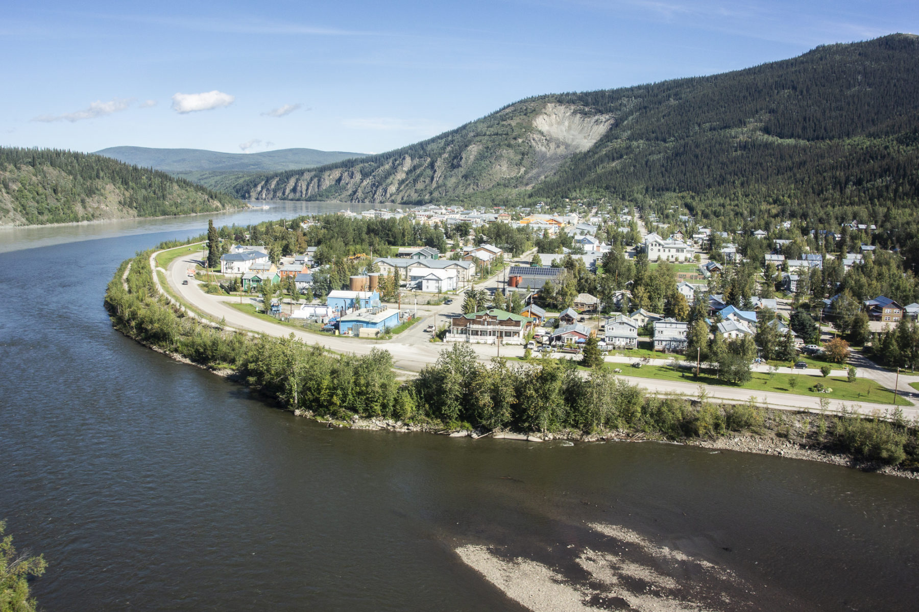
Tombstone Territorial Park, north of Dawson City (and, if you’re not lucky enough to get a chopper ride in, is reached via, firstly, the Klondike, then the Dempster Highway) covers more than 2200 square-kilometres. The park’s landscape ranges from boreal forest and high, dramatic mountain peaks in the south (including Tombstone Mountain, right where we landed), through to the contrast of rolling subarctic tundra in the Blackstone Uplands of the north.
The altitude here ranges from around 550m in the Chandindu River valley up to the 2350m summit of Mt Frank Rae. The park is criss-crossed by numerous waterways, including the Tombstone, North Klondike, Chandindu, Blackstone and East Blackstone rivers. It is also host to the annual migration of the 120,000-strong Porcupine caribou herd, claimed to be the longest migration of any land animal on Earth. Inside this park are plenty of hiking trails, campsites, rivers to paddle, and wildlife, plus the excellent – and must-visit – Tombstone Interpretive Centre, which showcases the park’s geology and First Nations history.
The land of the giants
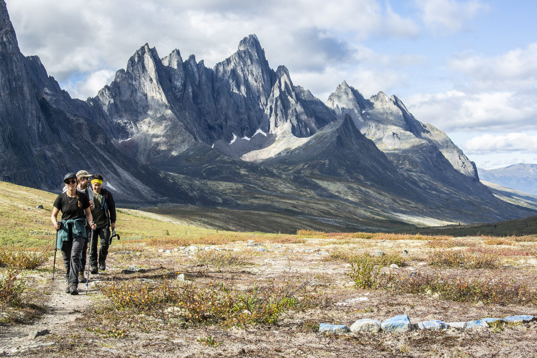
A few minutes to wait for the chopper to leave, and a few more last-minute shuffles of gear, and Kevin and I shoulder our packs and start following the track up toward Tallus Lake and its perfectly-located campsite and cooking shelter – a common theme in this park, as we found out later… For us today, though, Tallus Lake is a short stop and photo op, before we continue to our first-day goal of Divide Lake, where we will be spending our first night.
It’s hard to describe the vastness of this territorial park. It combines grasslands with those aforementioned jagged peaks (a constant companion on our three days here), along with some of the most beautiful lakes (and the rivers that flow from them), tucked in underneath the towering stone giants. It’s as if a pro photographer has designed the landscape for optimum impact and, if that was ever the case, it certainly delivers; I spend more time gawking at the scenery than I do watching where my boots are being placed on the undulating track, swivelling between the more rounded summits of the Cloudy Range to our north, and the Tombstone Range’s dark-grey ramparts to our south.
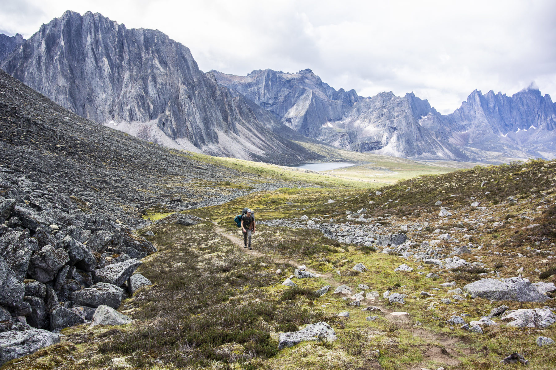
I am also straining my eyes to look for moving brown clumps up on the higher slopes of the Cloudy Range, in the hope that I may spot one of the park’s other famous native residents – the grizzly bear. Of course, I am hoping my viewing opportunity will be a safe one, with said bruin staying in the distance. We do have bear spray packed – a prerequisite for any visitors into the park, along with a compulsory safety briefing at the Interpretive Centre before you head out – so we are prepared if the extremely unlikely encounter does occur. Indeed, Kevin remarks that he has only seen one, and that was on his last trip, with it being way up the mountainside. The combination of a reasonable amount of trekking traffic along the trail, the strict adherence by campers to storing all ‘smelly’ items (think: food, toothpaste, etc.) in the supplied bear bins, and their focus on simply minding their own business, means a close encounter is far less likely. What I do spot – at around one-twentieth the size of a grizzly – is an overly curious hoary marmot, who follows us (at a safe distance of probably around 30 metres) for about two minutes as we negotiate a boulder field before we reach a plateau overlooking our final destination of Divide Lake. It negotiates the boulders at a much faster pace than the two pack-carrying humans it’s following do. Nothing beats nature.
To divide but never conquer
The descent to Divide Lake takes us close to the lake shore, before we walk beside this impressive body of water to, firstly, where our (raised) tent sites are, and then on to the cook shelter, where one of the Park Rangers is just finishing up his meal. These shelters resemble a canvas A-tent, on a larger scale, and include a large timber table for preparing of meals. Nearby are the bear bins, where all our smelly/odour-emitting food and other gear is stored. It’s a good 100 metres away from the tent sites. It’s a relief to sit down (on a lightweight fold-up chair – my new best friend when trekking, I have decided) and drag out our individual bear barrels, with all our food. Kevin soon has the fuel stove burning away and we enjoy a hot coffee and some food, while I stare, entranced, at the huge lake and surrounding mountains just beside the cook shelter.
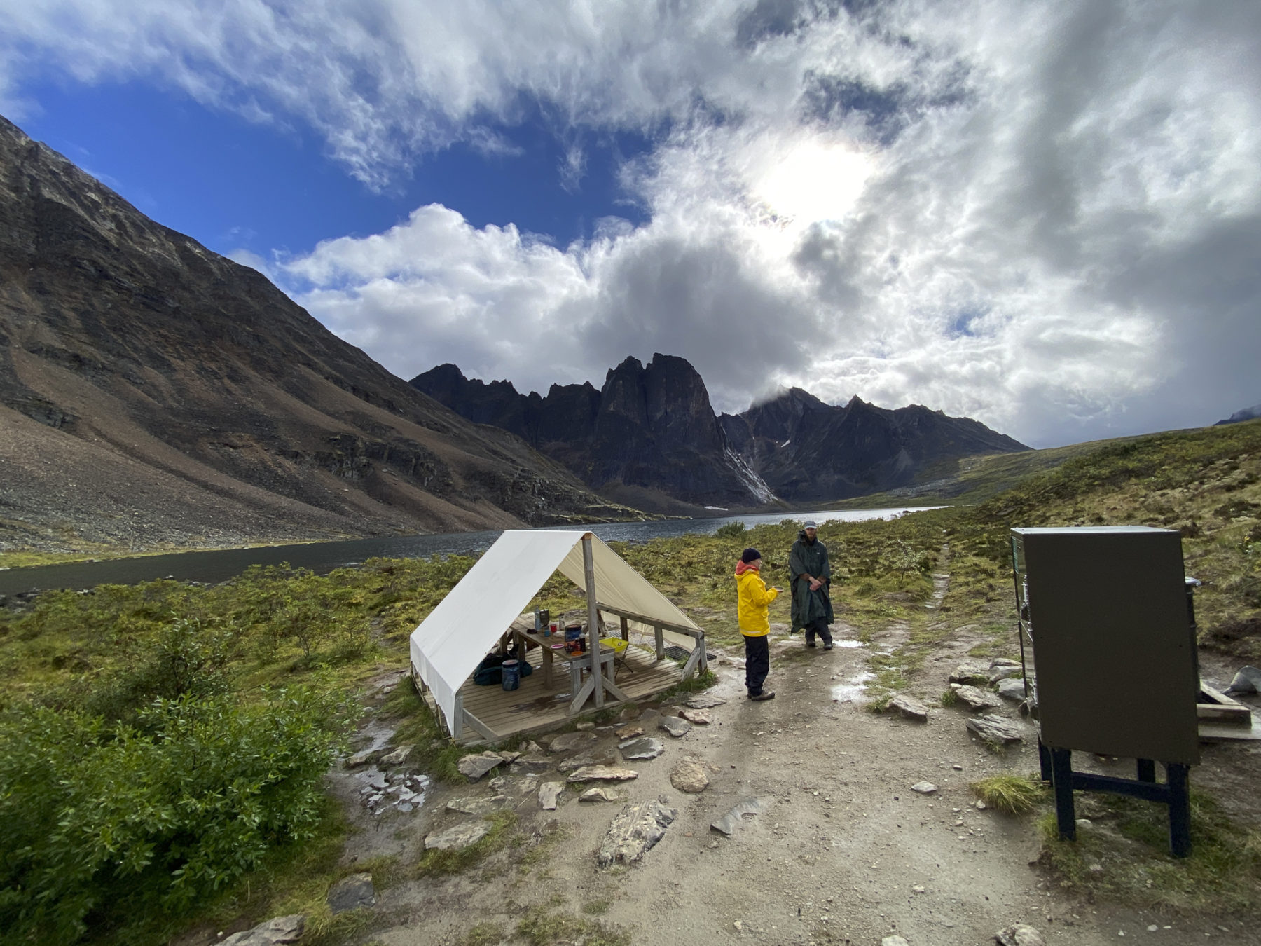

We’ve had great walking weather to this point – it’s a 6km trek that, with photos, took us about two and a half hours – but as I look out to the view for about the twentieth time, I notice dark clouds looming on the southern horizon. A quick mention to Kevin has us both charging back up to the tent sites, hoping we beat the incoming rainstorm. And we do – just – and then I spend the next hour just lying in my tent, enjoying the sound of water on nylon. It’s been a long-ish day, but my mind is already moving toward a slower speed; you’d think the immense surrounding landscape would seem intimidating, but it’s actually more like a welcoming envelope of nature, lulling your mind into full relaxation mode. After a hectic few days of long flights, finally arriving at this majestic location has really set my mind at ease. Yeah, it’s probably a cliché, but when the only sound you hear outside is either wind or the patter of raindrops on your tent, your mental state reflects that tranquillity.
There and back again
Our plan for the second day is to retrace our steps to Tallus Lake. However, for those with more time, you can continue north, toward pretty Grizzly Lake, and then continue on from there to the Dempster Highway. Eight years previously, I had walked into near Grizzly Lake, so I knew I wasn’t missing anything new (it is, however, a spectacular campsite and landscape for those who haven’t been there before), and so we have a leisurely start the following morning, and take the time to chat more with Caelan, the park ranger, as well as Jolee, a lady trekking the route solo. The temperature overnight – around -5 degrees Celsius – saw some snow drop on the summit of Mt Frank Rae, and it was still there the next morning.

The return to Tallus kicks off with an initial climb back up to the plateau, passing a couple with their dog (a miniature Australian Shepherd, one of two dogs we meet during our three days), before dropping down toward Tallus Lake. From our final high-point, the view is just gobsmacking: the Tombstone Range sprawls below us, with the snow-dusted peak of Horn Mountain and Mt Frank Rae on the opposite side.
The descent to camp is like walking into a fairy tale land of mountains and lakes; the sun is out and it’s too good a day to not do something extra, so we do. Kevin points out an inverted wedge-shaped cliff that, he says, has a lake directly below. We negotiate the undulating track, and a rock-hopping traverse of the Tombstone River, before we arrive at a natural amphitheatre. The cliff plunges nearly 90 degrees into the lake and it is spectacular. Too soon, we are heading back to camp, where we are joined by another group of hikers for an evening of yarns and laughs. No, it doesn’t get any better…


A final morning anywhere in the wilderness is a bit sad; leaving such a special place, no matter how many days you have spent there, can be hard to do. Kevin helps with the separation anxiety by cooking up some epic pancakes and bacon – and more coffee, of course – before we pack up camp and start the 1km amble down to the helicopter landing site. We’d mentioned the afternoon walk to the other group of hikers the night before, and we pass them on the way to the heli-pad as they are making their way back. Their eyes are lit up with excitement from what they saw down there and, even as I know it’s an impossibility, I am seriously tempted to turn around and join this group for another few days.

Kevin and I laugh about that as we wait for the heli. Both agree on the reason for that dreamlike moment of rashness: no matter how long you spend in Tombstone Territorial Park, the park’s sense of being a timeless, naturally wild place rubs off, to the point where you wish time in the rest of the world moved as it does here.
THE RIVER OF DREAMS
If there’s an outdoor activity that could be classified as synonymous with the Yukon, it would have to be paddling. The canoe is, of course, a Canadian icon – and the Yukon has myriad rivers and lakes suited to this craft – but there is also plenty of kayaking (both flat and whitewater) and rafting available on a number of rivers, too. It really is a matter of “picking your poison” in terms of finding a waterway (or 10!) that you can paddle your favourite watercraft in. And it all starts with the territory’s namesake river…
The Yukon River is one of the canoeing world’s most famous bucket-list journeys and, if you have the time, the journey from Whitehorse north to Dawson City, replicating the route taken by the ‘stampeders’ in the Gold Rush era as they rushed to the Klondike goldfields, is simply brilliant. The ‘full monty’ version of this journey takes between 14 and 20 days.
For those with less time, you can opt to paddle either the Whitehorse to Carmacks leg, or the Carmacks to Dawson City one. Of course, even a day paddling this famous river is great fun and there are plenty of operators, who provide guided day paddles, or canoe hire for those wishing to tackle the big river independently (with a pick-up and return to Whitehorse at the end of the day).
For me, it is going to be three days, thanks to Yoshi of Sweet River Enterprises, and experienced paddling guide, Kate Moylan. Yoshi and Kate are super organised and efficient, starting with us all meeting the day before the river journey starts. All my gear is checked for its suitability to the trip, and I am given a 70L drybag in which to store all my clothing and gear. We also chat through the route and what we can expect along the way.
In the beginning
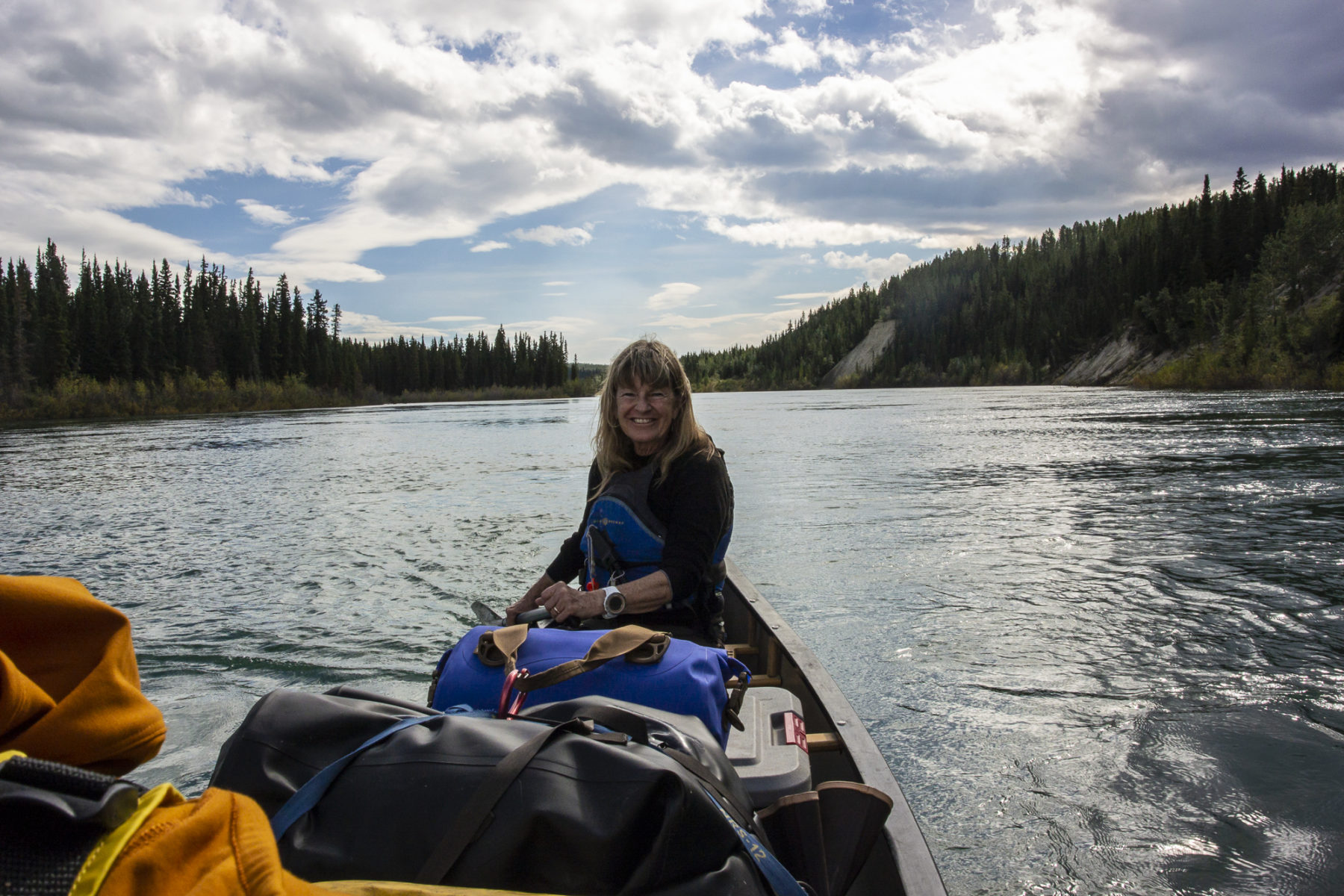
Packing a canoe is always like a game of Tetris; making sure all the gear fits – and that it keeps the canoe balanced, weight-wise – is the focus, and it proves so again on this first morning on the river. Appropriately, we are tackling the river journey in a 17-foot Prospector canoe; as the name suggests, its design is modelled on the craft used by those early fortune-hunters. The canoe’s size means all our food, water, cooking gear, camping gear, dry bags, an extra paddle – and ourselves – are all accounted for and tied down securely after about an hour of shifting and swapping gear positions around. Now, it’s time to join the Yukon.
The river runs quite fast – you could down paddle and float and still make distance – but after me re-learning and practicing a few paddle strokes to Kate’s satisfaction, our paddles dip in and we add extra propulsion to what will be around a three-hour journey to our first campsite. Initially, we pass Whitehorse and a few other housing estates but already, and even though we are still very close to ‘civilisation’, being on the river seems to remove us from the surrounding noisy world. The oft-hypnotising sound of a regular paddle stroke, and our own conversation, make us feel like we are on our own on the water. And we are. For most of this first afternoon, it is just one canoe, Kate and I moving with the ageless flow of the Yukon. We spot a couple of juvenile bald eagles along the way, but otherwise it is just us and the river.
Treasure island
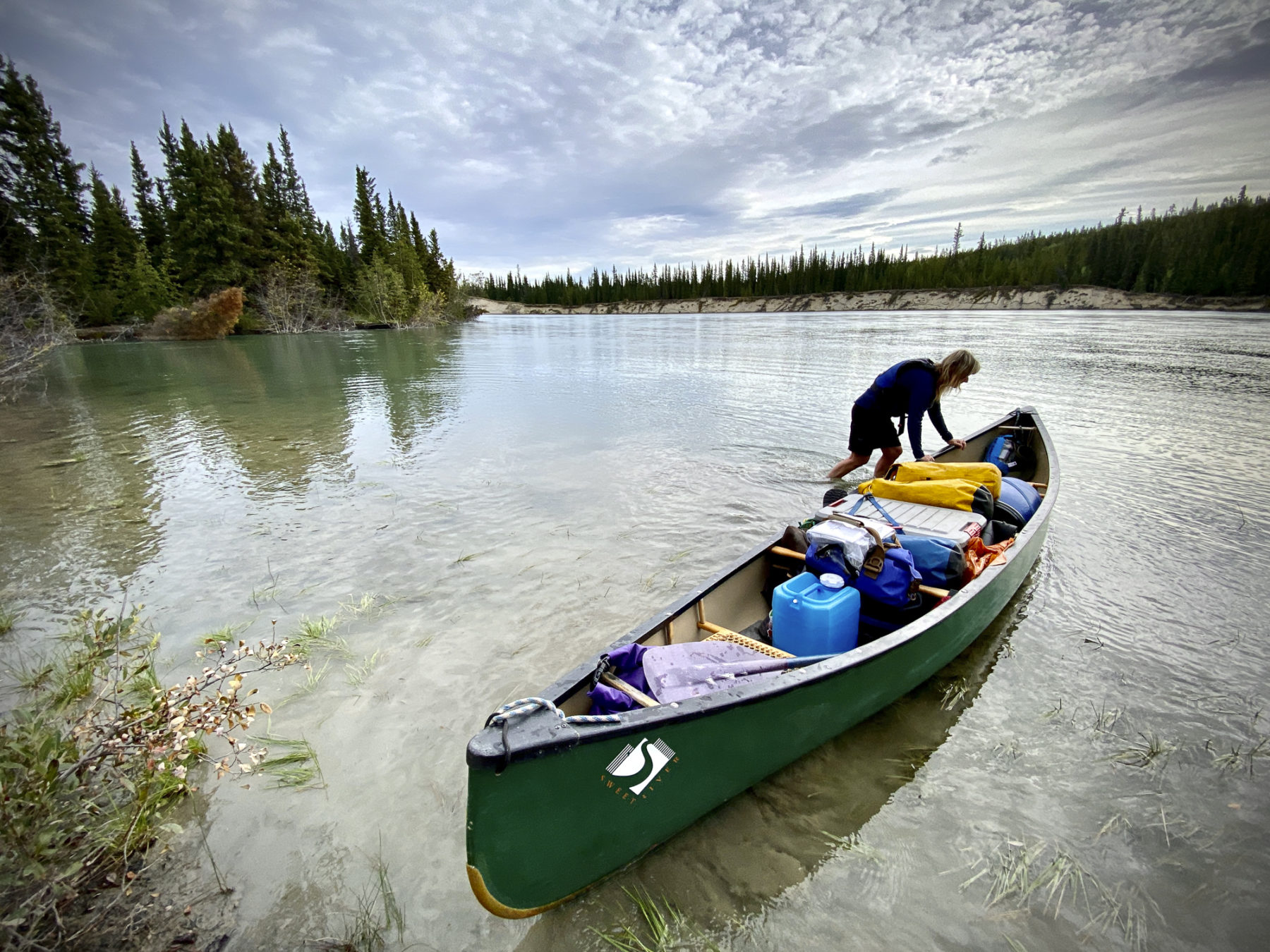
Map-makers can, sometimes, possess a sense of humour, and this is never more evident than when I see our first campsite and hear its name. Egg Island is tiny, and appropriately, situated below the larger Duck Island – get it? Duck and egg synergies aside, the island is beautiful – our very own slice of Yukon River paradise. It also provides some excitement for us paddlers as, due to the unusually high water level on the river during our time on it, we have to do a bit of ferrying (crossing a fast flow on an angle, aiming at particular landing point) to reach a take-out point. That small burst of paddling power is worth it, though, as the island is all ours for the night and it’s not too long before Kate and I have set up a camp kitchen (again, being bear-aware, it is well away from our tents’ riverbank location) and enjoying some smoked salmon and canapés, before grilled salmon and vegetables for dinner, followed by a dram of rum, all while sitting beside a campfire and chatting about paddling’s eternal appeal. Sipping the rum, I wonder what those early fortune-hunters would have thought, if they could see us now…

We are blessed with more good weather the following morning – and I am spoilt with more good nosh: a hot coffee is waiting when I emerge from my tent and then Kate cooks up a storm of bacon, egg and cheese muffins, while I start packing drybags and stoking the campfire back to life. It’s what spending time in the outdoors is all about: not rushing, enjoying being in the moment, and knowing that, very soon, you’ll continue your adventure, again at the whim of the river’s flow and that welcome wind at your back.
Our next camp is at Steamboat Slough, a larger island on the river that has, according to Yoshi, some brilliant camping. The journey there takes us around four hours and, along the way, we have our first encounter with other canoeists. This time, it’s a guided group who are doing the big paddle from Whitehorse to Dawson City. A few shouted ‘hellos’ and ‘good lucks’, accompanied by shit-eating grins from both our parties, and they are past and gone.
Soon, we are passing the mouth of the Takhini River, a whitewater-filled adventure that I was lucky enough to experience on my first-ever trip to the Territory. I remember that day, launching through rapids and the high adrenalin it induced but, funnily enough, I don’t wish I was there again; today’s more tranquil paddle is allowing me to absorb more fully the where and what of the Yukon River.
Heaven on earth
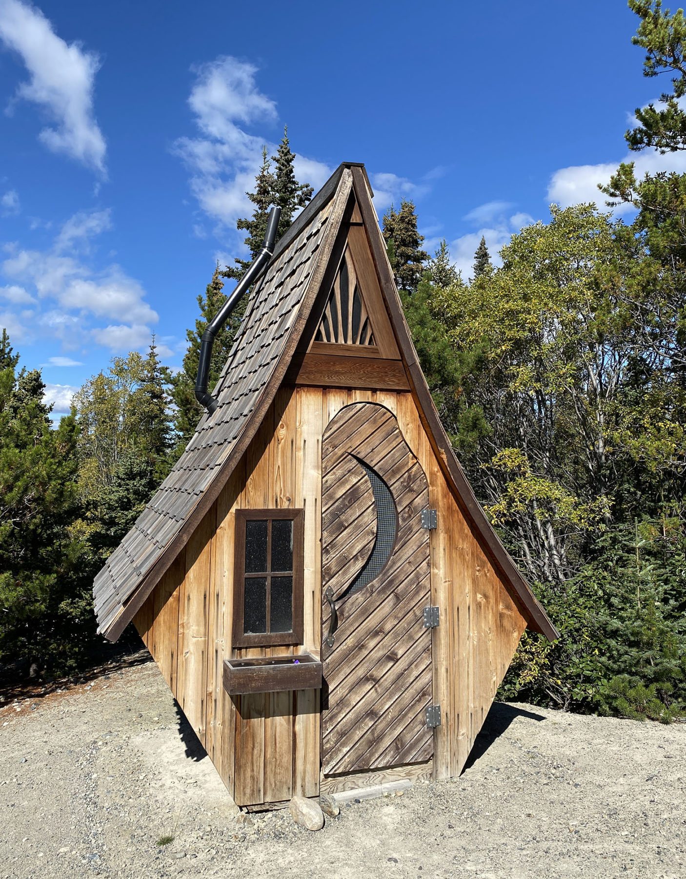
Finding a ‘nice’ campsite is up there at the top of any multi-day paddler’s wish-list and we definitely score when we pull into the camp at Steamboat Slough. The large campsite has with a picnic table and what is probably the most unique ‘bush outhouse’ I have seen in my travels. From our camp kitchen (we utilise our large tarp and cover the picnic table to convert it to the cooking area) we watch the emerald-green rush of the river going by and, in the distance, the river winding toward Lake Laberge, bare rock-faced mountains dominating the distant skyline. We even hear the splash of salmon as they continue their journey upriver back to their spawning grounds. It’s a wild and rugged land here, and I catch myself often in awe of what the early gold prospectors achieved, travelling this river in what were, mostly, flimsy self-made rafts and small boats.

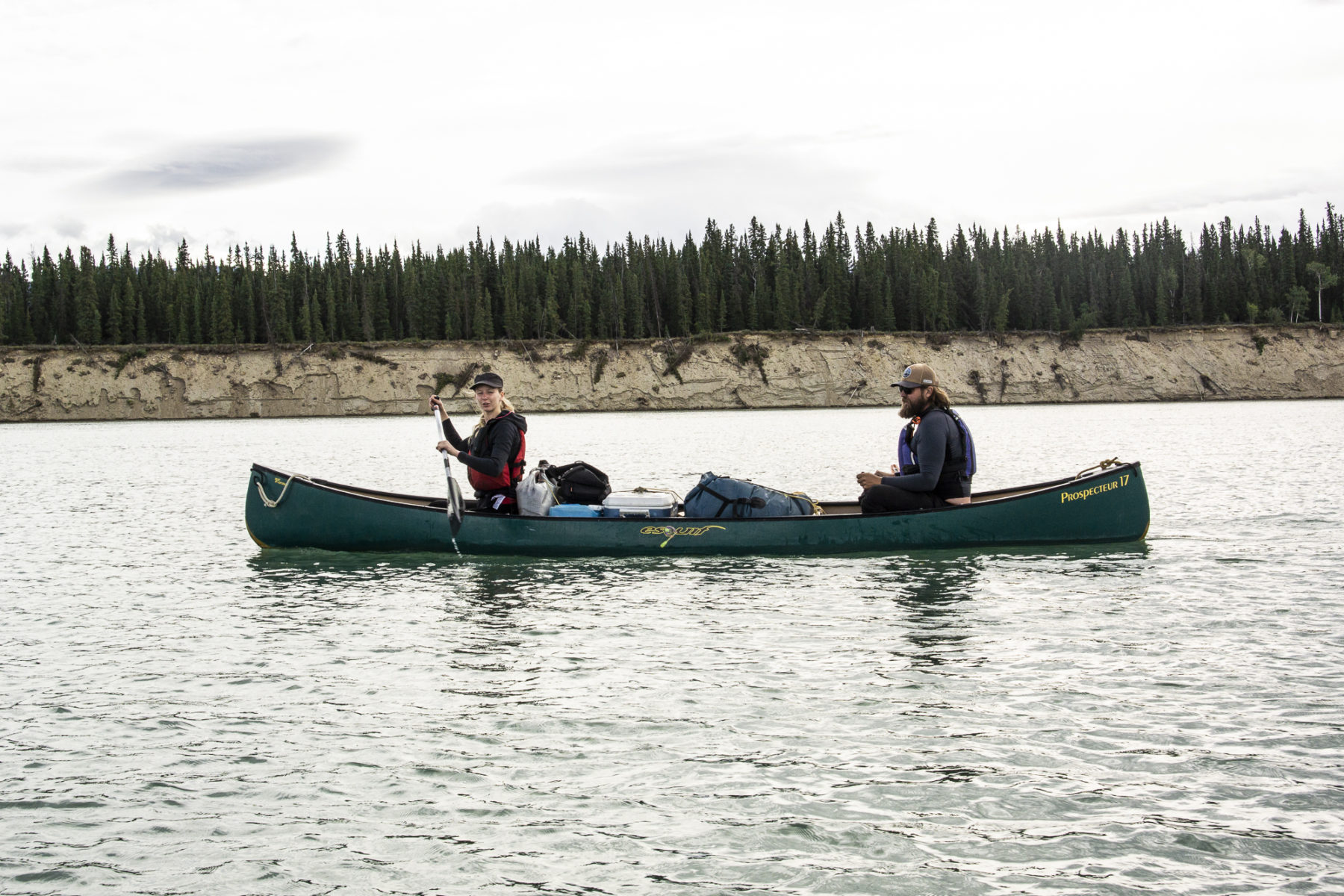
For us modern adventurers, it’s an afternoon of coffee, snacks and more paddling talk before another smaller guided group of five paddlers, in three canoes, arrives – this group heading to Carmacks over eight days. They look slightly envious of our Taj Mahal-like camp kitchen setup and also share a laugh with us when they discover that unique bush loo, before setting up camp at the far side of the campsite’s cleared area.
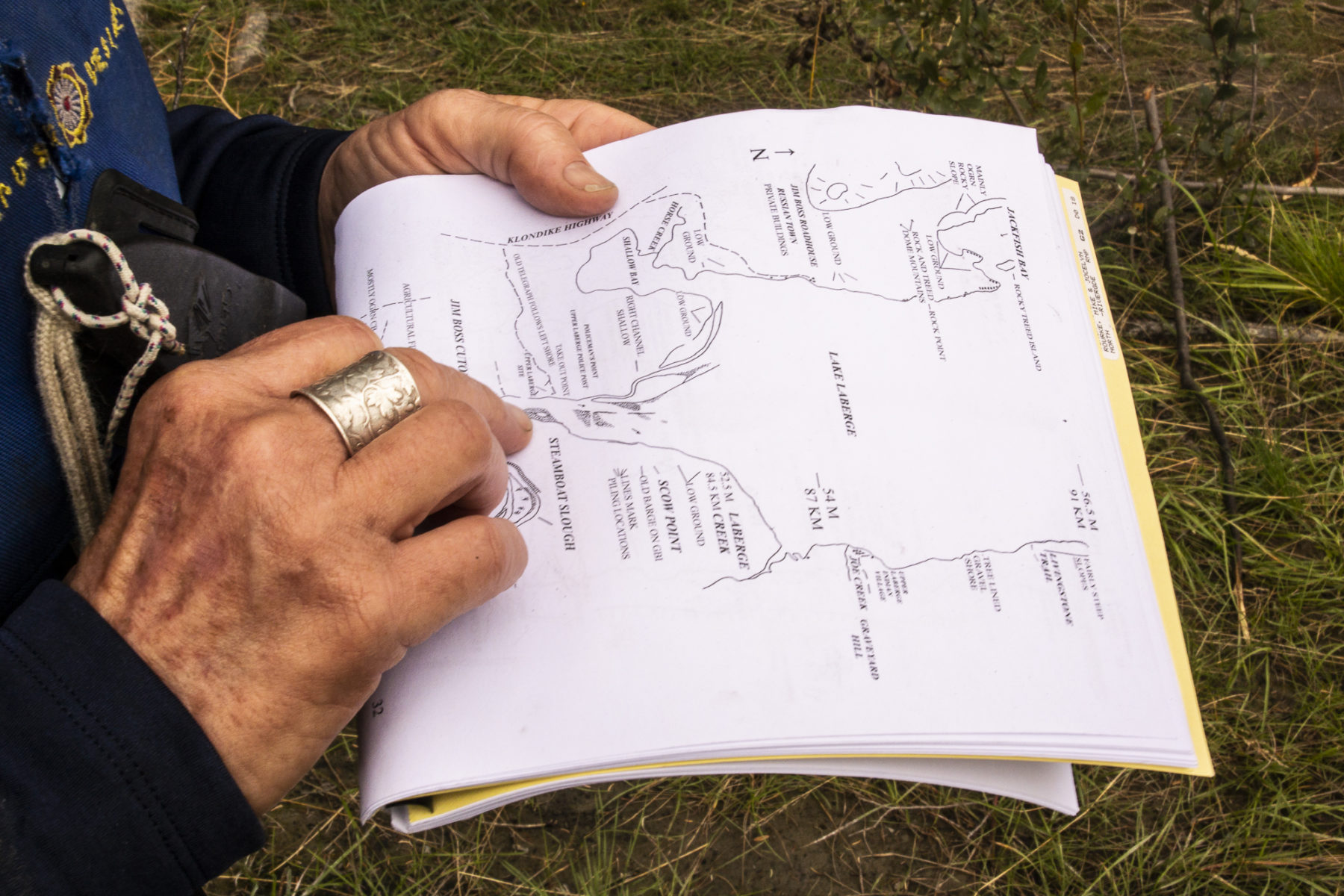
Kate and I discuss the next (and final) day’s leg over dinner and rum. There’s a chance we may cop the dreaded headwinds as we move north on to Lake Laberge itself. The reason it is a concern is the lake is simply immense. At around 48km long and between two and five kilometres wide at various points, its size is hard for me to get my head around – we simply have nothing of that scale in Australia. Kate mentioning this huge body of water actually freezes over winter makes it even more so! She also mentions how it can take days to traverse the lake, before joining the 30 Mile section of the Yukon River if conditions are not favourable. It is the wind that causes issues for paddlers; large waves can be kicked up by a strong headwind and that makes paddling a canoe where there is no shelter from said wind, a tough task. We discuss a few early landing options but decide that, until we actually reach the lake mouth the next morning, we won’t know for sure.
The passage
Paddlers are generally advised (and Kate concurs) that the lake’s eastern shoreline is the preferred route for canoes. However, for us, we need to stick to the more open western side due to the fact that our pull-out point is Shallow Bay, on that side of the lake. We strike it lucky again this final morning, though, with minimal wind to speak of.
It’s a dreamy and surreal feeling paddling out into the wide expanse of the lake-mouth, with its size making us feel ever so insignificant and the day’s utter stillness adding to that ethereal sensation. We do lose our friendly and supportive tailwind on the lake – and the river’s fast flow is muted somewhat in such a high volume section of water – but we make steady progress up the lake’s western shoreline. I admire a number of lakeside houses along this part of the lake and wish (crazily, I know) that I was fortunate enough to own one. I mean, after all, if you had the funds, what could be better than a lakeside cabin in the Yukon for its summer?

Our final leg on this morning takes us toward the large Richthofen Island, before our pull-out point at Shallow Bay. I don’t know if it’s me, or Kate, or both of us, but we seem to be taking more than the usual time to cover distance now. I put it down to the fact that three days on the Yukon River has taught (especially) me that life’s pace does not need to be pushed; the river’s natural and timeless flow – and my journey with it – has given my mind and body a huge re-set. This hits home dramatically when I am helping pull the canoe out of the water for the last time: I have stopped, and although I feel both tired and exhilarated, my mind is already being filled with that sense of urgency so prevalent in our modern world. In contrast, the Yukon River continues to go on – and will so forever, at its own pace, and in its own time. In an odd sense, paddling the river aligns with how it represents freedom and a feeling of timelessness, both of which I intend experiencing again in the future. After all, there’s still a lot more Yukon River to explore…
TWO WHEELS ON HIGH
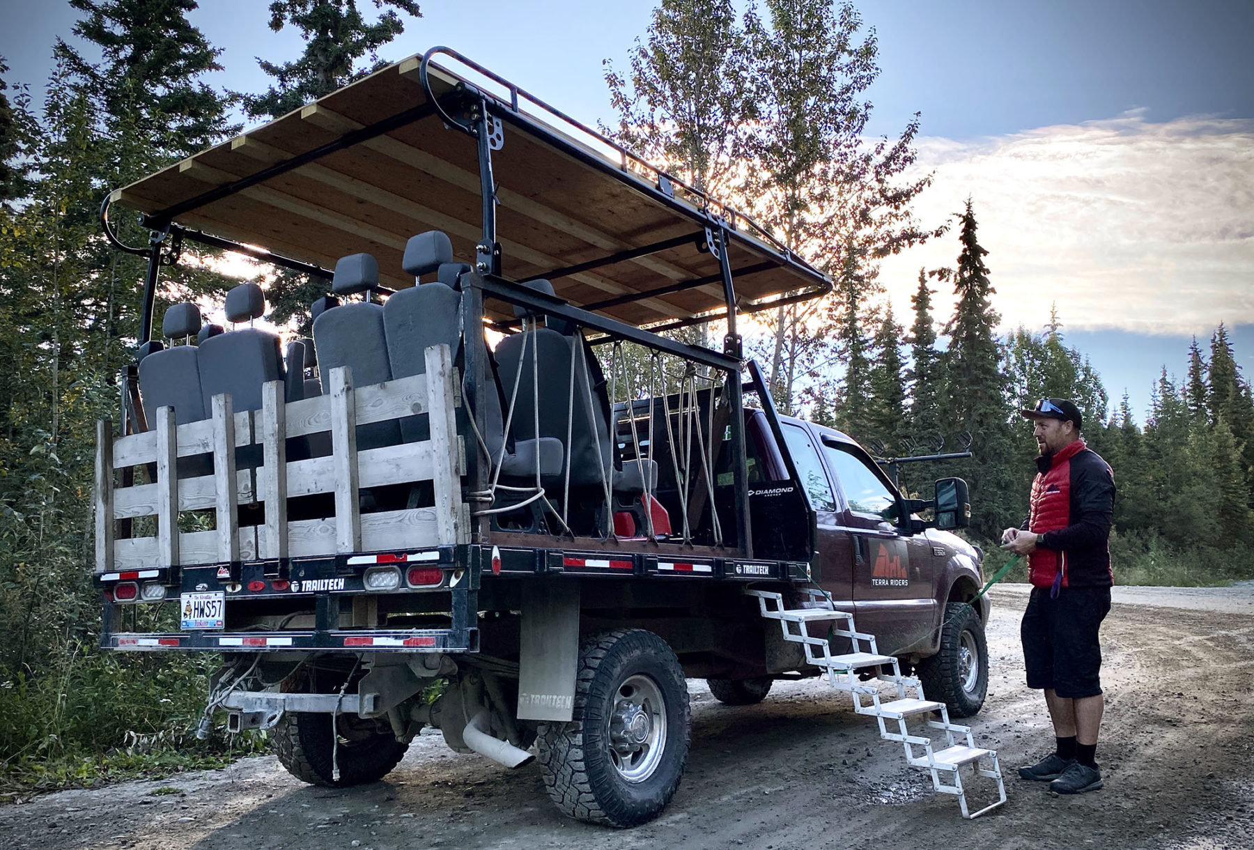
I am sitting on a mountain bike atop Mt McIntyre, the Yukon capital of Whitehorse far below myself and Terra Riders Yukon’s Daniel Sams. We’ve just driven up this peak in his mammoth shuttle rig – a monster Ford F250 with a stadium seating setup out back – and dropped off a group of four ladies from British Columbia’s Campbell River, who are here on a mountain biking week, sans kids and husbands. I can just hear them whooping and hollering as they crest a rise further across the mountain top, on their way to finishing a 35km MTB ride back to town. Now, it’s quiet, with just a whisper of wind, as Dan fills me in on Terra Riders, surely the dream business to run if you’re an adventurous soul.
“Terra Riders was in my mind for a good 10 years before I actually got it off the ground,” he says. “There were a lot of funding options for extra curricula sports in the UK at that time and it seemed that I could fuse my love of two wheels and youth work together.
“I found a mountain bike instructors course in Whistler in 2010 then got rather distracted by an unexpected life in Canada until 2019 when we officially launched Terra Riders after moving to the Yukon in 2018. The primary focus was, and is, for youth and kids’ programs during the summer months, but tourism is a way to give our coaches the occasional well-earned break from the “Little Terras” and a variety of work options throughout the year.
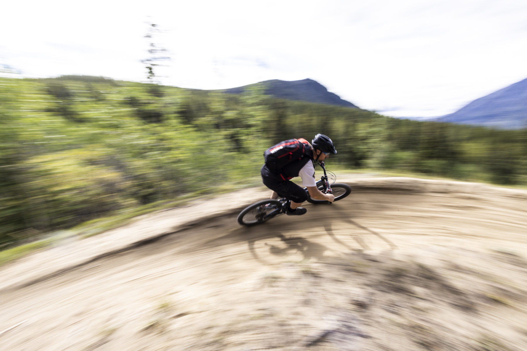
Our “well-earned break” is a day sampling, firstly, Blown Away, a Blue grade 2.4km descent, starting here at the top of Mt McIntyre, and then, later on after lunch, an afternoon getting a taste of the famous MTB trails of Carcross, about an hour’s drive south of Whitehorse.
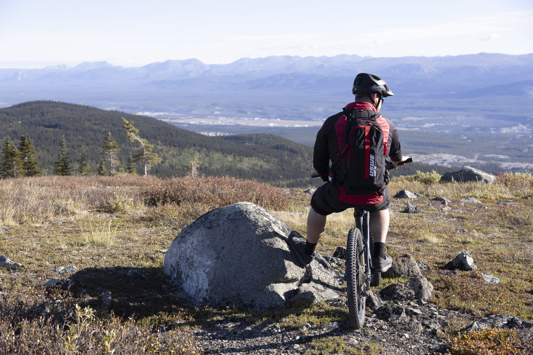
Dan describes the riding in the Yukon as “a more rugged, traditional mountain biking experience, with high alpine trails for day-long adventures” and Blown Away fits that bill exactly, with its slightly techy feel, along with plenty of rocks, some sharp uphill pinches, and tree roots further down in the forest section. Up high we can see forever, looking over huge Fish Lake to the west and Whitehorse and the Yukon River to the east. It is brilliant riding, requiring a bit of focus but not at the expense of pure fun. The high meadows are soon replaced by forest as we descend, winding through narrow trail sections and enjoying this trail’s natural features to the full.
Blown Away is just one of numerous MTB trails surrounding Whitehorse – there is more than 700km of trail surrounding the city – and Mount McIntyre contains a number of other notable rides, such as Starbucks Revenge and the Porcupine Ridge Trail. Closer to town – and more mellow – is the Yukon River Trail, while Grey Mountain provides loads of cross-country rides or some cracking downhill runs, such as Money Shot, a 700-metre descent to the Yukon River.
Grabbbing the wolverine by the tail
Mountain biking has grown in popularity incredibly quickly in the Yukon over the past decade, as Dan confirms when he says, “It seems there are more cars with bike racks than not, often with a value of bikes on them that far surpasses the value of the vehicle carrying them!”
And, really, it’s not hard to see how that has happened. The territory’s landscape feels like it has been shaped perfectly for mountain biking, with its big mountains, rolling hills, deep valleys and old First Nations and prospectors’ routes providing the base for what is hundreds of kilometres of trails and some amazing trail networks throughout, with a mix of trails for all rider skill levels.
One of the Yukon mountain biking success stories is Carcross. An hour south of Whitehorse, this town has become a global hotspot for mountain biking tourists. This is due to the hard work by members of the community – not the least the local First Nations youth who, through a programme called ‘SingleTrack to Success’ built an amazing trail network on Montana Mountain, just out of town (a 2016 documentary, “Shift” details this great story). The result is a combo of sweet flowing singletrack, and trails graded from beginner through to expert.
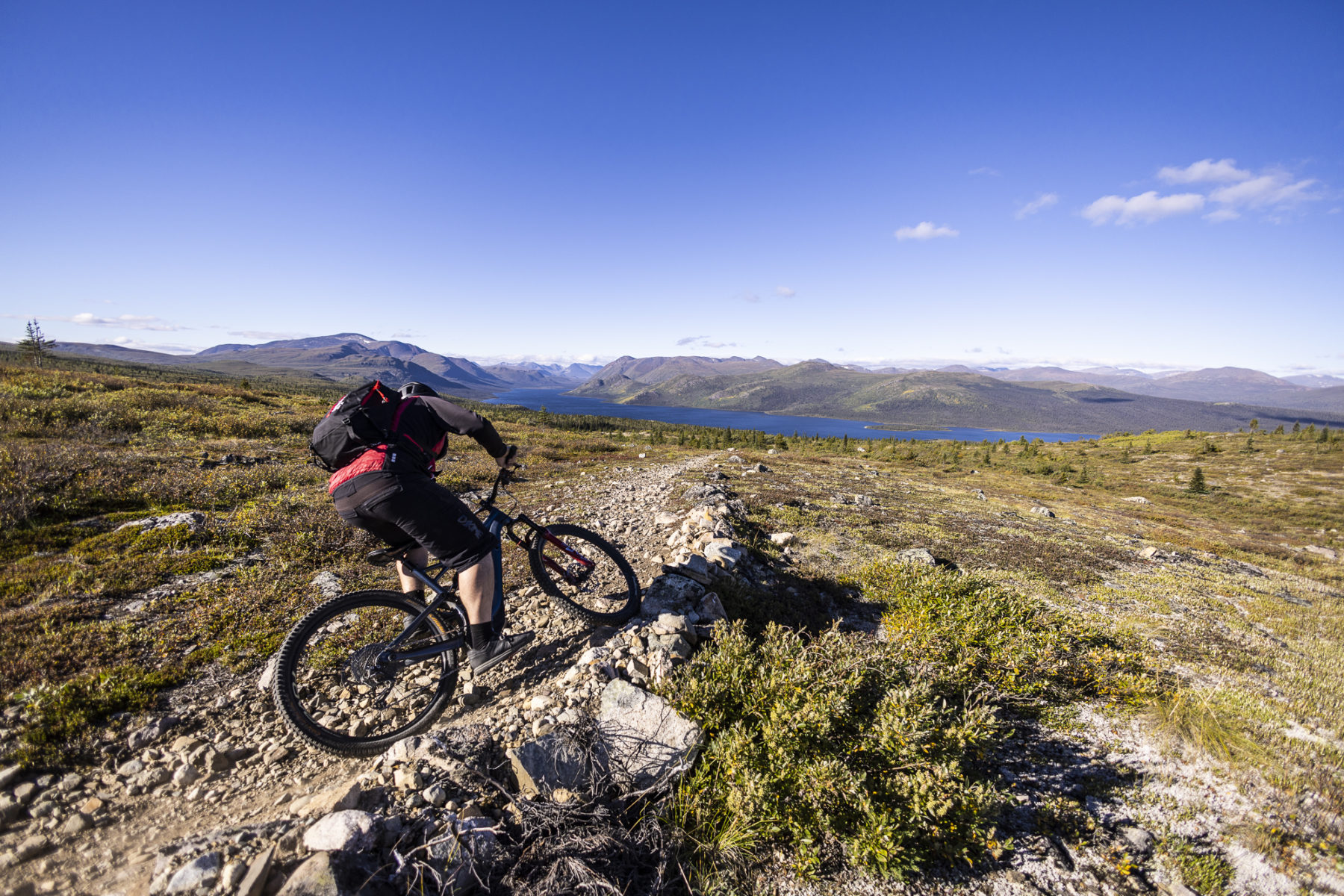
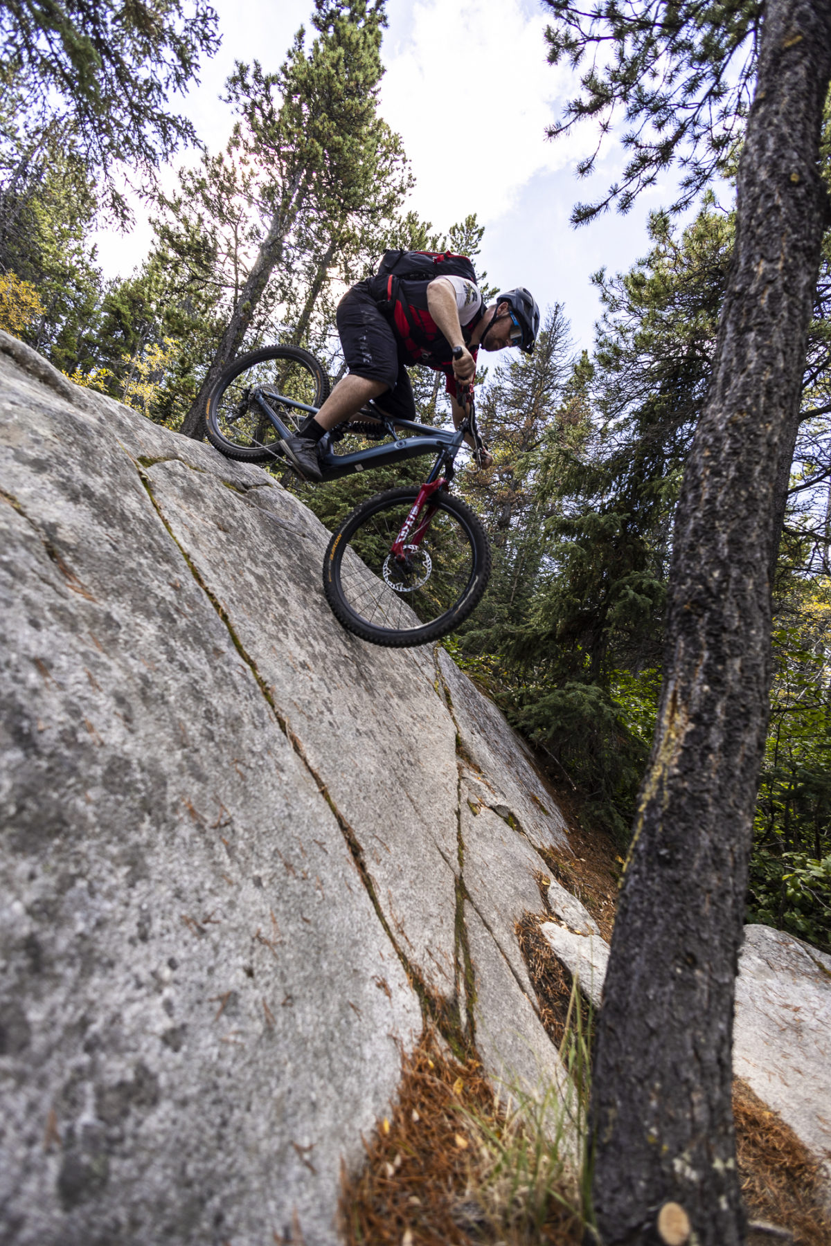
Today, Dan and I are here at Montana Mountain to ride the awesome Upper Wolverine, a Black Diamond grade downhill, that becomes Lower Wolverine (Blue Grade) further down. The reason for the grading separation? Upper Wolverine contains a long and technically challenging section of huge rock slabs and tall boulders, along with sizeable drop-offs, rooty singletrack and a few ‘skinnies’ (very narrow timber ‘bridges’ – not more than a couple of tyre widths across – that connect some of the larger boulders). For this, ahem, unashamedly intermediate-grade rider, it’s an eye opener but, with Dan’s coaching and encouragement, it turns out to be an absolute hoot.
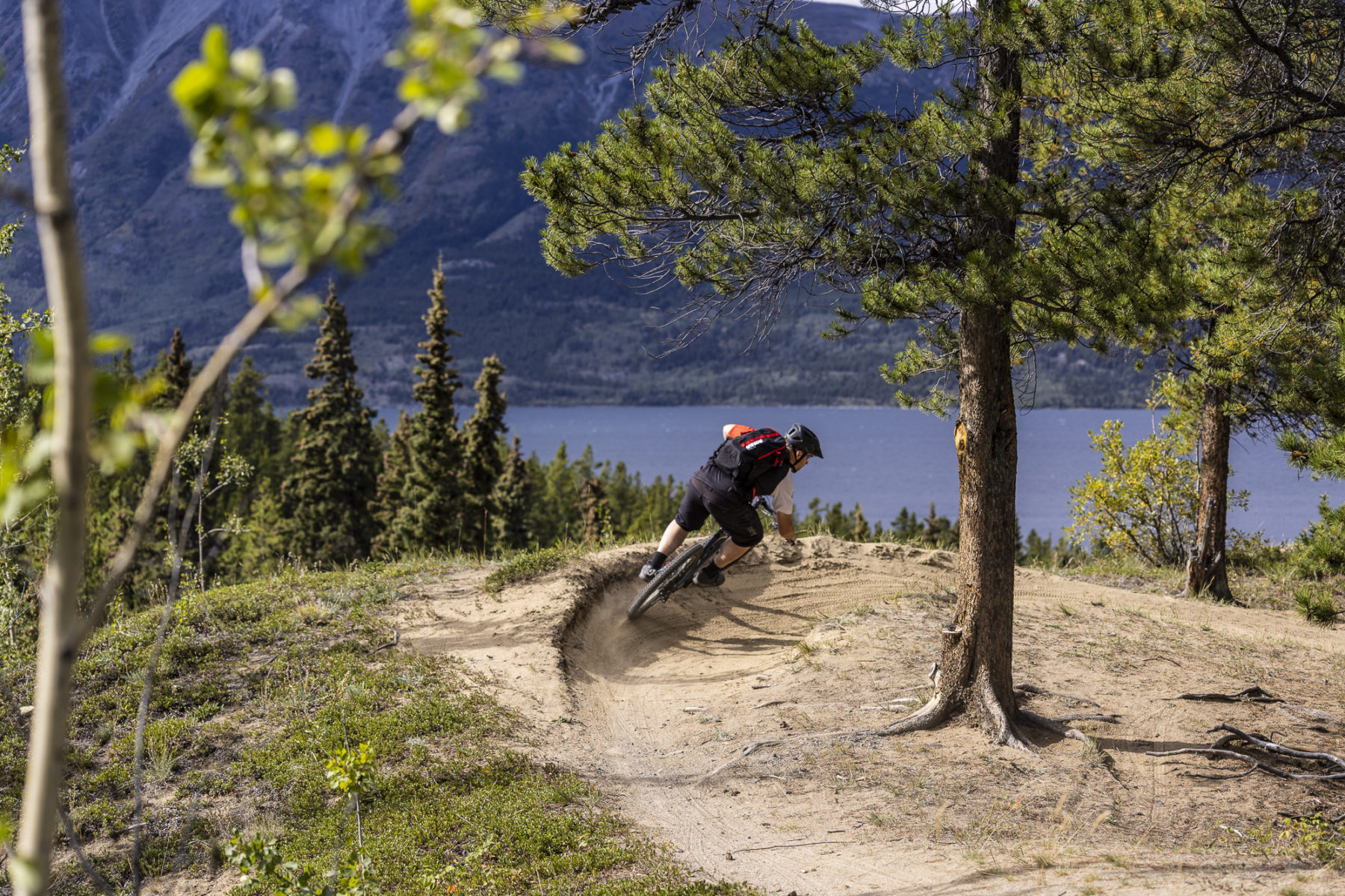
Linking on to Lower Wolverine sees the trail ease off in terms of technical difficulty, replacing the tech with swooping, speed-encouraging berms and longer stretches of open trail, including the iconic “Photo Corner”, which sees riders turn at some speed into a sweeping right-hand berm above Bennett Lake, far below. From Lower Wolverine to Fox is more winding and faster singletrack, before we pop back out on the main access road up the mountain. Here, Dan leaves me, utilising his e-MTBs pedal-assistance to wind his way back up the road to pick up his truck, while I continue on my MTB dream ride – this time, following the aptly named Mossy. This Green rated trail is as fun – and fast – as you want to make it, with the dirt ribbon of the trail cutting through the bright green, moss-clad (hence the name) landscape. All too soon, like the rest of this MTB day, it is over, and I have popped out at the bottom of the mountain, with only a footbridge to negotiate before making my way to one of Carcross’s cafes.
For any visiting riders to the Yukon, both Whitehorse and Carcross need to be on your list – and you need to allow plenty of time. The trail networks here are very well signposted and there are so many trails to choose from, you don’t want to rush it. And, best of all, whether it’s a coffee in Carcross or a craft brew in Whitehorse, there are loads of after-ride food and drink establishments for after-ride celebrations.
The Yukon at its best
It’s a hectic but incredibly amazing eight days in the Yukon Territory. For anyone who loves the outdoors and hiking, paddling, biking, camping, history, and cultural enrichment, there are few places that offer all this in such abundance. After each of my different adventures here, I meet up with Yas Yamamoto, Yukon Tourism’s Market Development Manager for Asia Pacific, at one of the many excellent eateries in Whitehorse. I am sure by the end of the last day he’s heard enough of me espousing the virtues of trekking in Tombstone TP, paddling the mighty Yukon River, and screaming down a steep MTB trail in Carcross, but he politely nods his head in appreciation each time. I mean, after all, he lives here, so he knows just how much of an adventure wonderland the Yukon Territory is and how, for locals, it doesn’t even need to be said, it is just up to us visitors to the Yukon to say it, loudly and appreciatively. If you want to jam the most adventure and excitement into a week or more, then the Yukon Territory can deliver it, and then some.
*This writer travelled as a guest of Travel Yukon.
Fact file: Travelling to the Yukon Territory
Getting there: This may surprise some, but even though the Yukon Territory seems like it is at the ‘ends of the earth’ it is not – and getting there entails a straightforward journey. Flights connecting Australia’s eastern seaboard (the majority from Sydney) to, firstly, Vancouver, and then directly on to Whitehorse mean you will be absorbing the spectacle that is the Yukon in no time at all. If you fly into Whitehorse on Air North, make sure you try its famous warm cookies. They really are worthy of their reputation, trust us…
Getting around: The roads and highways in the Yukon are excellent and this, along with the long hours of daylight, mean road trips are brilliant fun here. Signposting is in abundance and very clear, and the Yukoners themselves are overwhelmingly friendly and helpful if you do need to ask for directions or tips on where to eat and stay. One thing: don’t forget Canadians drives on the ‘other’ side of the road to us Aussies. It sounds like a big thing but is not at all.
Guided treks: For visitors, heading out on a trek, paddle or MTB ride with a local guiding company (also known as ‘outfitters’ in the Yukon) is a no-brainer.
Trekking in Tombstone: The Klondike Experience offers multi-day (and single day) trekking adventures in Tombstone TP and other areas, along with day trips, excursions to historic sites in and around Dawson City, charter transport, bike rentals and customised tours, Jesse Cooke’s Klondike Experience team are brilliant.
Yukon River canoe trips: This writer paddled the Yukon River with Sweet River Enterprises (www.yukonriver.com). Other canoe guiding companies that offer trips on the Yukon’s many waterways, include Canadian River Expeditions, Up North Adventures, Kanoe People and Ruby Range Adventure.
Mountain biking: Terra Riders Yukon provides a host of mountain biking adventures, ranging from a day to a week or more of guiding, as well as e-MTB and city cycling tours. It also has a unique Pedal & Paddle Experience, with MTB trails followed by a canoe trip down the Yukon River. (It also offers longer Yukon River canoe trips, too, as well as a cool Aurora Canoe Tour, during aurora viewing season.)
Weather: The Yukon in spring and summer means long days and short nights – especially in mid-summer and more so in the far north of the territory – which means there’s no rush to cram every day full of adventure; there are, literally, plenty of hours in each day. Be aware that in more remote and more northerly locales, weather can change quickly, so be prepared with appropriate clothing.
Accommodation: As well as the excellent wilderness lodges throughout the territory, the Yukon has options ranging from camping and RV parks and B&Bs, to hostels, hotels, motels, and rentals.
More information: Whether it is suggested visitor itineraries, excellent info on the various parts of the territory, ideas for how to plan for a visit, accommodation links, informative blogs or loads more, the Travel Yukon website is brilliant.