
Rocking the Riverina
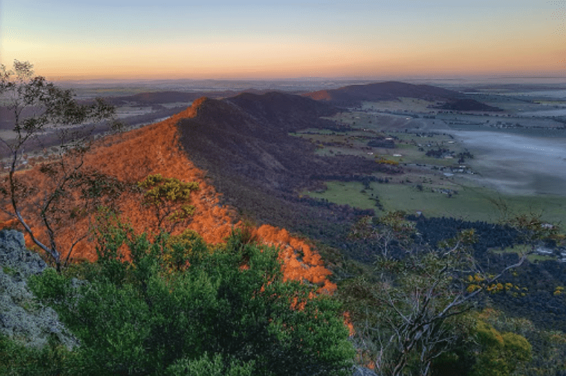
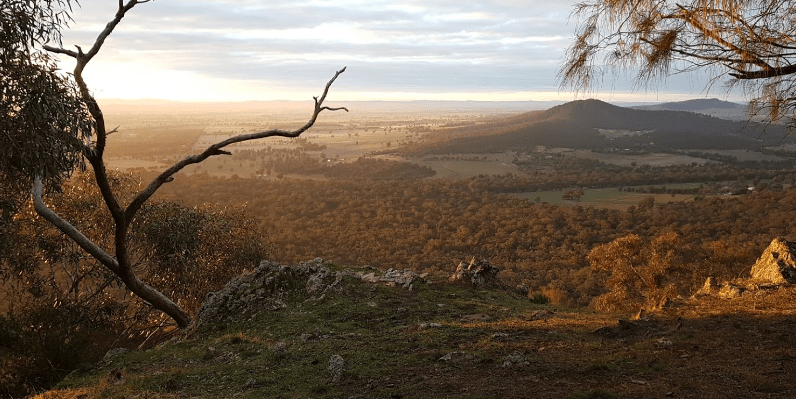
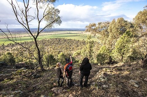
RISING 364M ABOVE surrounding plains, the heaving monolith known as The Rock has superb views of a patchwork of farmland, rolling hills and ranges, and even Mt Kosciuszko on a clear day, as well as the Bogong Range and Victorian Alps. Located less than 5km from the nearby township of the same name and 37km east of Lockhart, The Rock Nature Reserve – Kengal Aboriginal Place is the best-known natural landmark in the Riverina.
The reserve offers walks, birdwatching, rock climbing and abseiling. There are interpretative boards, and picnic facilities including fresh water, barbecues, shelters, tables and toilets. The Rock is plainly visible from the picnic spot, so families looking to pass an easy afternoon should bring a packed lunch and enjoy the shade.
Try the Yerong Walking Track, a moderately difficult climb to the top of The Rock, with breathtaking views and an exhilarating tour through currawangs and white box trees. You might even see a wallaby or glossy black cockatoo. The walk to the top of The Rock takes about 3 hours return. Keep your eyes peeled for wildflowers like bluebells and yellow wattle bloom. Near the bare cliff tops, Dwyer’s mallee gum and drooping she-oak have taken root.
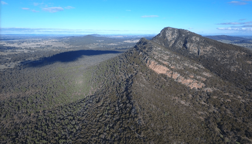
For the adventurous, there’s rock climbing and abseiling on the north-east rock face (facing the picnic area) known locally as The Towers. This is the only cliff stable enough to be used for rock sports and covers about 100m. Make sure you carry the necessary equipment, are sufficiently experienced, and limit your party size to four for rock climbing and eight for abseiling.
While there are no campgrounds here, visitors can find places to stay in the nearby township of The Rock. Shops and further picnic facilities are available there.
Whether you’re looking for something slow or something adrenaline-filled, The Rock Nature Reserve – Kengal Aboriginal Place is sure to deliver.
Yerong Walking Track
Leaving directly from the car park near the information point, this pleasant and accessible walk takes visitors to the top of the dramatic The Rock formation. It begins gently, crossing small gravelled slopes between graceful red gums.
As you climb higher, the path begins to wind around recessed cliffs hiding cool woolly ragwort plants – a threatened species native to the area that blooms with yellow flowers. Wallabies scatter through the undergrowth, lizards bask in the warm sun, and you may see glossy black cockatoos or wedge-tailed eagles circling overhead. Birdwatching only gets better the further you climb. There are more than 100 species in the reserve including Brown Treecreepers, Turquoise Parrots, Glossy Black Cockatoos, White-brown browed Babblers, Thronbills, Honeyeaters and Eastern Yellow and Red-Capped Robins. As well there are grey kangaroos, swamp wallabies, echidnae, possums and marsupial mice.
This hike becomes steep towards the end – the bare rock of the ridge is covered in lichens and moss – so make sure you bring some sturdy shoes and plenty of water. The payoff is notable, though, with a spectacular scenic vista across bush and rolling farmland from the top of The Rock, providing an excellent opportunity for photography. Just a short trip from Wagga Wagga, this is one of the best lookouts in the region. Galore Hills is often visible to the west, and on clear winter days the snow-capped peak of Mount Kosciuszko rises in the distance.
It’s believed that initiation ceremonies were held at The Rock in the past as the creek just to the south is known as Yerong, a Wiradjuri word meaning “place of initiation”. The Rock became a nature reserve in 1962 having been crown land for 100 years. The Wiradjuri people called ‘The Rock’ – ‘kengal’.
The Towers
The Towers, right near The Rock picnic area, offer a thrilling adventure for rock climbers, abseilers, orienteering groups and photographers alike. Located in The Rock Nature Reserve, the north-east cliff face of The Rock is a challenge to anybody with experience and the necessary equipment.
Peregrine falcons use The Towers as a nesting sight, offering birdwatchers close-up views of these magnificent creatures. Keep an eye out for peregrines on the cliff and observe their telltale whitewash streaks below their perches.
To reach The Towers, follow a 670m narrow walking trail opposite the picnic shelter and look for the register book. The best time to climb is between January and the end of June. Photographers will love the remarkable view over the surrounding countryside.
Note: The peregrine falcon breeding season spans 1 July to 31 December. The Towers are closed to rock sports during this time.
Nearby towns and attractions
The Rock
Located in a wool and wheat district, the small country town is named after the dominant local geological feature, a craggy outcrop which can be seen from miles around. Today it has become a quiet, commuter town for Wagga Wagga, which lies to the north. The township is located 4.2 km from The Rock Nature Reserve on the road to Lockhart.
Lockhart
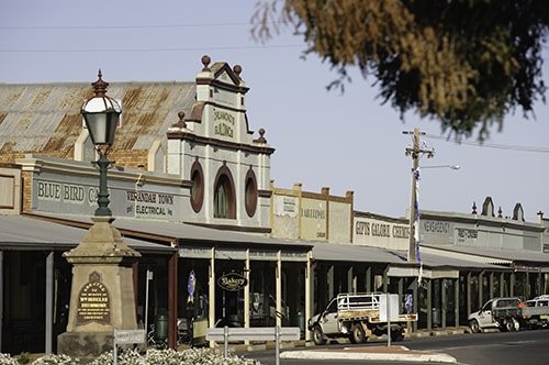
Lockhart is a charming Riverina town noted for its remarkable main street (Green Street) with its shady, decorative verandas and beautifully restored facades. It is recognised and classified by the National Trust as an important repository of turn-of-the-century architecture. Plaques on the shops provide historic details. A wander along the town’s main street reveals the history of the district etched in pavers. Lockhart is now a commercial and business service centre for the surrounding rural community where wheat, sheep, wool, cattle and poultry dominate the economy.
Located 521 km south-west of Sydney via the Hume and Sturt highways, Lockhart was originally known as Green’s Gunyah after a roadside inn run by a Mr Green. It changed its name to Ferriers when a man named Ferrier took over the inn but was finally, and formally, named Lockhart after the Commissioner for Crown Lands in the area in the 1850s, a Mr C.G.N. Lockhart.
Things to See and Do
Lockhart’s Hotels and Bank
The town has two old hotels both of which have a certain rustic charm. The Railway Hotel was built in 1908 and the Commercial Hotel (1906) is a charming Federation pub with a balcony of carved woodwork.
The Pioneer Memorial Gates
The Pioneer Memorial Gates, which were erected in 1962, are a tribute to the pioneers and early settlers in the district. Twenty-two replica wool bales form the entrance to the Lockhart Showground and are located on the road to Urana. The replica wool bales have the names of the area’s original homesteads stencilled on them and the gates are silhouettes of the bullock carts which were used to carry the bales. The Showground Grandstand, built of local Murray pine, and the nearby bar pavilion date back to the late 19th century.
Greens Gunyah Museum
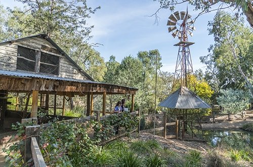
Located on the corner of Green and Urana Streets near Brookong Creek is the Greens Gunyah Museum which is run by the Lockhart & District Historical Society. The museum houses an extensive collection of historical artefacts and photographs. It also includes the Doris Golder Gallery of layered wool art which consists of portraits and landscapes constructed in natural coloured fleece wool. As well there are artefacts from Brookong Station and information relating to the history of the Shearers Strike on the property in 1888.
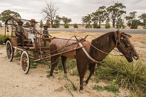
Pastoral Shadows of Brookong
The Pastoral Shadows of Brookong trail is a pleasant and easy circular walk which recalls the pastoral history of Lockhart with sculptures of drovers, horses and sheep, a couple of swaggies, brolgas, bullockies and carts and drays, all made from corrugated iron, offcuts from farm machinery, and rusted metal. The trail, which starts over the road from the Lockhart Motel at 1 Green Street, has detailed signage. It was constructed by the local community with the help of a farm art sculptor, Stuart Spragg.
Spirit of the Land Festival
Held each year on the second weekend in October, the Lockhart Spirit of the Land Festival showcases the kind of Farm Art featured on the Pastoral Shadows of Brooking trail. These are sculptures made from farm materials, recycled metal and other elements. One year a prancing horse made from parts of motor vehicles was featured jumping over a bale of hay and entire horse and carriage ensembles, complete with passengers, have been made from miscellaneous pieces of metal.
Galore Hill Nature Reserve
Galore Hill is located 13 km north of Lockhart on the Lockhart-Narrandera Road, this 510 ha rnature reserve rises 215 m from an almost flat plain. It has grey kangaroos, echidna and lizards, 140 species of birds, and 850 types of native flora including flowering native plants in spring. There are several walking tracks and a road leads to the summit where there are picnic, toilet and barbecue facilities and panoramic views from the lookout tower. It is claimed that the bushranger ‘Mad Dog’ Morgan used the caves on the northern side of Galore Hill as a refuge when he was being hunted down.
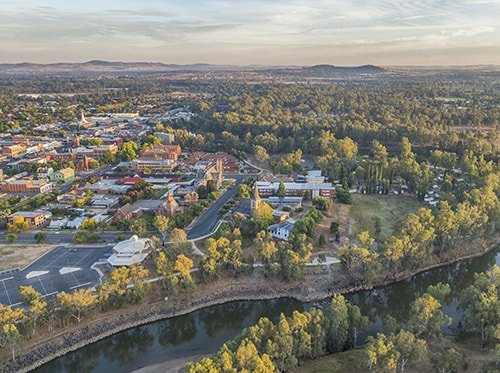
Wagga Wagga
The largest regional centre in NSW, Wagga Wagga is located on the banks of the Murrumbidgee River, is considered the main commercial and administrative centre in the Riverina region. “Wagga”, as it is known to the locals, is a city of fine buildings, tree-lined streets, excellent museums and galleries, parks and gardens. The city’s appeal lies in its diversity. You can swim in the Murrumbidgee; walk along an Aboriginal trail; visit impressive galleries and museums; have fun at a boutique brewery; and admire truly impressive historic buildings and parks. Its location between Sydney and Melbourne and its rich diversity of services have ensured that it is well catered for as far as accommodation is concerned.
The regional centre is located 214 m above sea-level and 460 km south-west of Sydney via the Hume Highway and Sturt Highway.
It has been claimed that “wagga wagga” is a Wiradjuri Aboriginal word mean “place of many crows” but Stan Grant, who is one of the last Wiradjuri speakers, claims that it is a word used to describe sacred ceremonies in which a man dances in circles with a wonderfully rolling, rollicking gait. “Look at that man. He is gripped by the sacred spirit. He is dancing in a trance and going round and round … yes that’s truly Wagga Wagga.”
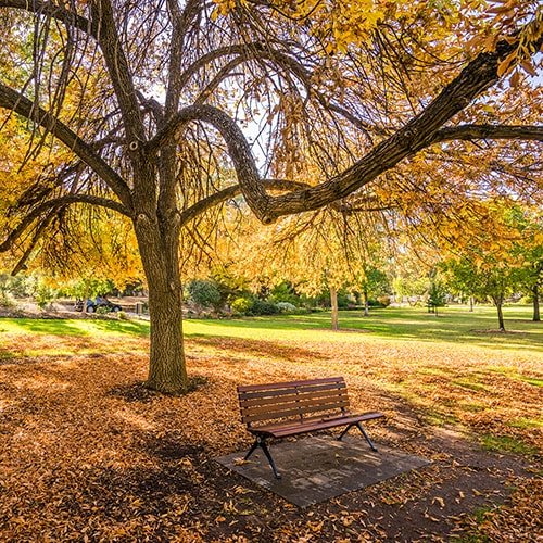
Botanic Gardens and Museum of the Riverina
Wagga’s Botanic Gardens are remarkably diverse. Spread over 20 hectares they include a Shakespearian garden designed as an Elizabethan garden with formality and careful seasonal planting; a tree chapel for weddings; a large children’s play area; an island and bamboo garden; a cactus and succulent garden and a rainforest garden. There is also a zoo and aviary with a special Children’s Zoo with ducks, rabbits and chickens
The Museum of the Riverina
Located next to the Botanic Gardens on Lord Baden Powell Drive, the Museum of the Riverina features displays relating to the people, places and events surrounding the town’s history. One of its most impressive possessions was a bullet fired by bushranger Dan Morgan in 1863. Sadly it was stolen. The main exhibition is housed in Yallowin Hut (1834), which originally stood on the now-flooded Tumut Valley under the waters of the Blowering Dam. The museum includes a series of buildings which depict aspects of the early history of the district.
Wagga Sporting Hall of Fame
The Museum of the Riverina includes the Wagga Wagga Sporting Hall of Fame which includes detailed biographies of such local luminaries as Mark Taylor, Peter Sterling, Paul Kelly, Michael Slater and Geoff Lawson. It’s an impressive acknowledgement that the district has produced great sports people out of all proportion to its population. Like the Museum it is open Tuesday to Saturday from 10am-4pm and Sunday 10am-2pm.
Willans Hill Miniature Railway
Run by the wonderfully named Wagga Wagga Society of Model Engineers, this miniature railway has over 2km of track weaving through the grounds, crossing a bridge and going through a tunnel. It is located in the Wagga Wagga Botanic Gardens.
Victory Memorial Gardens
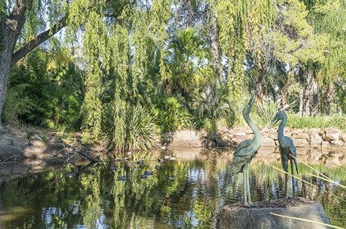
The Victory Memorial Gardens are edged by the Wollundry Lagoon, a billabong off the main Murrumbidgee River, and the little-known but peaceful Collins Park (between Thompson and Forsyth Streets) with its unusual memorial to the men from Wagga who served in the Anglo-Boer War 1899-1902 (the one made famous in recent times by the movie Breaker Morant). It is a memorial to nearly 100 soldiers from Wagga who served in this little-known campaign fighting for the British Empire because, when the first soldiers departed on 23 October 1899, Australia as a political entity did not exist. By the 1930s the gardens had become a hugely popular local attraction. The Daily Advertiser reported in January, 1934 that: “These delightful gardens are becoming increasingly popular, and large parties make it a rendezvous, especially in the cool of the evening. No more delightful spot could be imagined, with the big sweeping green lawns and restful shady nooks.” The gardens also feature an avenue of poplar trees, a life-sized copper sculpture of the Jolly Swagman boiling his billy, the Pioneer Memorial Sundial, a sunken garden, a senses garden for the blind, a children’s play area, picnic facilities, swans, ducks, geese, waterfowl, fish and tortoises.
The Wiradjuri Walking Track
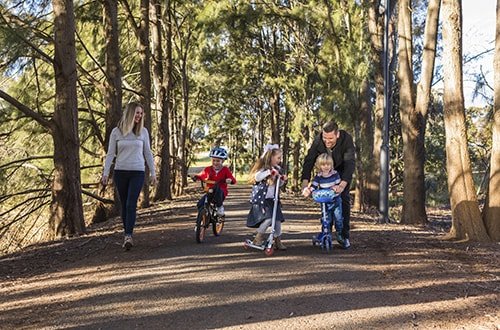
Wagga Wagga has the best Indigenous walking track in the state, and possibly in the country. The Wiradjuri Walking Track is a 30km trail around the city which starts at the Visitor Information Centre on the banks of the Murrumbidgee, makes its way under the railway viaduct, rises up to the Botanical Gardens, has panoramic views across Lake Albert, then descends to make its way along the Murrumbidgee passing Flowerdale Lagoon, Gobba Beach, the Wiradjuri Reserve and Bridge, and Wagga Beach.
Lake Albert
Covering 125ha the lake was constructed in the 1890s on what was known as Swampy Plain and was named after Prince Albert. It is a popular destination for those wanting to go water skiing, boating, swimming and fishing. There is a track around the lake which is suitable for walkers and cyclists.
Wagga Beach
While Wagga is not ordinarily associated with swimming, it’s not surprising that the Wagga Beach, towards the end of the Wiradjuri Walking Track, is a tempting place in summer. If you have never swum in an inland river this is about as good as it gets. The beach is substantial and sandy and there is something refreshing about swimming in fresh water which has come from the Snowy Mountains.
For more on these wonderful Riverina destinations head to Visit NSW.
Thanks to Bruce Elder, a regular contributor to Australian Geographic magazine. Bruce writes the Aussie Towns feature each issue. Head here to find out more about him and thousands of Aussie towns.

