Top 5 Tropical North Queensland road trips
1. Great Barrier Reef Drive: Cairns to Cape Tribulation section
Distance: 140km
Time: 2.5 hours
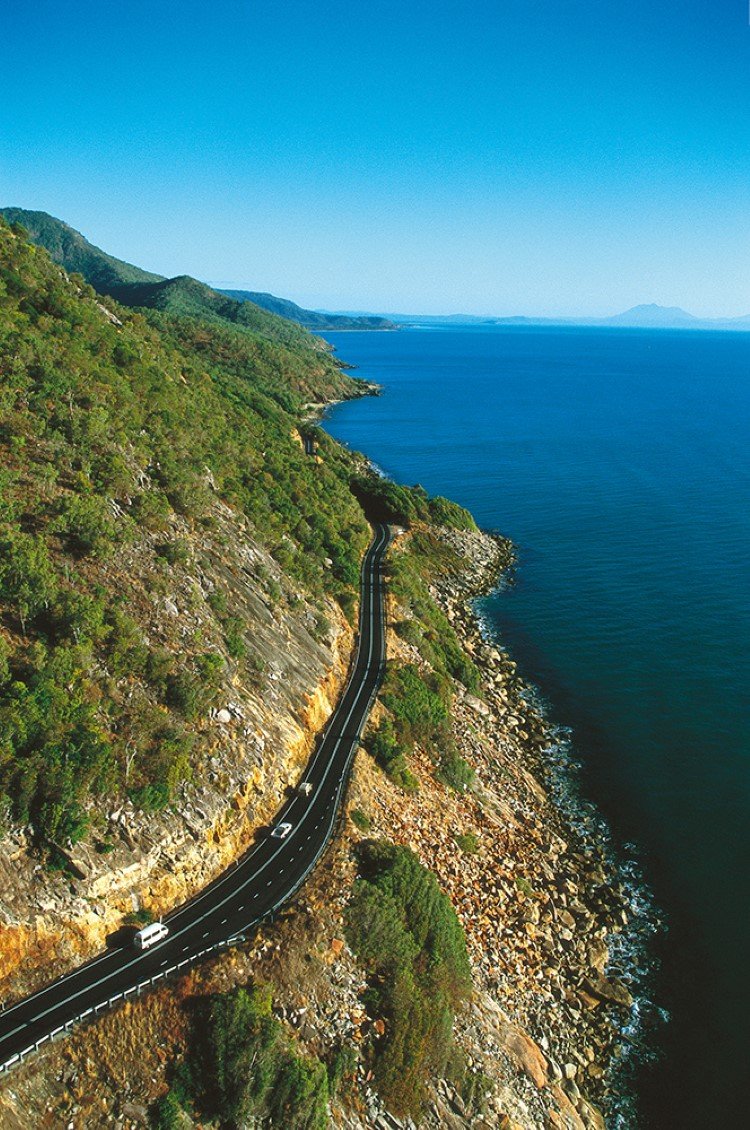
Captain Cook Highway. (Image: Tourism and Events Queensland)
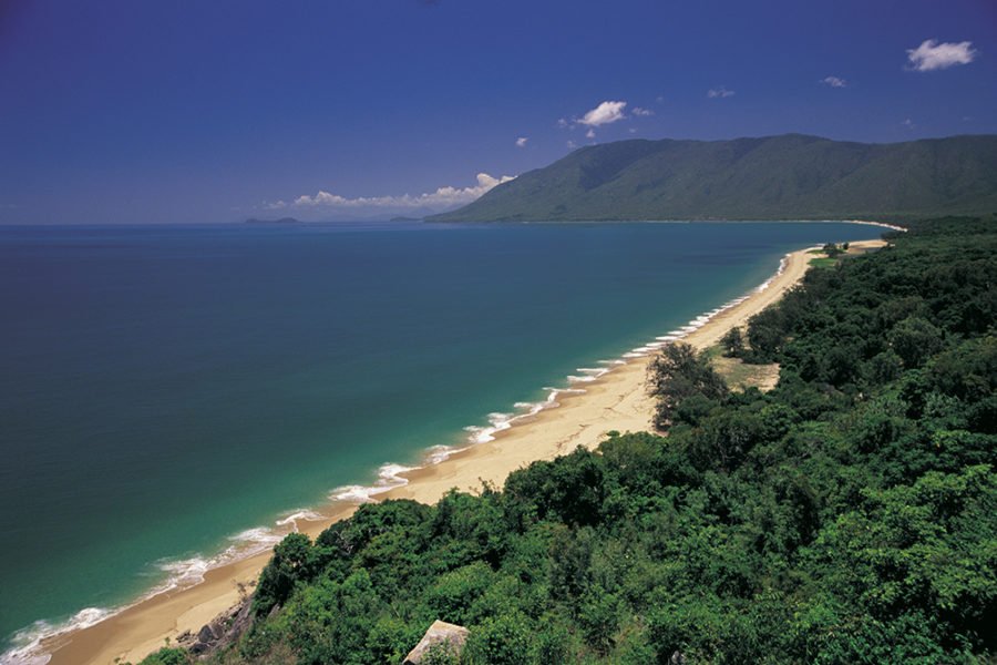
THE 140KM SECTION of the Captain Cook Highway and Cape Tribulation Road between Cairns and Cape Tribulation was rebranded The Great Barrier Reef Drive in late 2015 in a move to raise the profile of the famous scenic route. The local authorities are hoping that, ultimately, it will rival the Great Ocean Road as an Aussie tourism icon.
Once you leave the busyness of Cairns and its string of northern suburbs behind, you are in for a treat. The road hugs the pretty coastline and it can be hard to keep your eyes looking ahead because of the stunning scenes unfolding to your right. Stop at Rex Lookout for a glorious view across Trinity Bay.
North of the Port Douglas turn-off, the road passes through rolling cane fields backed by dramatic rainforest-clad ranges and the awesome sight of Thornton Peak in the distance. The mist that often shrouds the mountain’s double summit comes and goes as you proceed. Once across the Daintree River ferry, the road becomes quite narrow in places as it twists and turns through the Daintree Rainforest. Take a break at Walu Wugirriga (Mt Alexandra lookout) for a superb view across the rainforest canopy to the Daintree River estuary before setting off on the last part of the journey to the Cape.
The route crosses a series of bubbling creeks that tumble down off the rainforested ranges to empty across secluded beaches into the sea. Cassowaries are regularly spotted along this section so keep your eyes peeled and your speed down. From Cape Tribulation, it’s possible to do a small group half-day eco trip to nearby reefs such as Undine and Mackay aboard a semi-rigid inflatable raft with Ocean Safari.
2. Cooktown Circuit
Distance: 279km
Time: 1-2 days
There are plenty of waterways to enjoy while driving around the Cooktown region. (Image: Tourism and Events Queensland)
This loop out of Cooktown makes for a great exploratory drive without being too difficult on your vehicle and can be easily completed in an SUV or a 4WD.
Heading north from Cooktown along a short stretch of bitumen, you will follow Battlecamp Road as it loops north-west towards the entrance to Rinyirru (Lakefield) National Park. Along this northern section there are some nice waterways; Lake Emma (great camping here but book ahead) and Horseshoe Lagoon (more bush camping) are beside the road itself, with the ruins of Couch Grass Hut and the pretty Welcome Waterhole just off a side road and well worth a look as well. Your turning point south is reached at Old Laura homestead, which is situated on the banks of the Laura River, and well worth exploration. From the homestead you drive south for 27km on more dirt road before reaching the township of Laura. Turning south-east at Laura you join the sealed Peninsula Developmental Road and head towards Lakeland. Then, it’s just a short 82km drive along the Mulligan Highway back to Cooktown. This drive can be done in a longish day, but we’d definitely go for two.
3. Canecutter Route
Distance: 162km
Time: 3-4 days
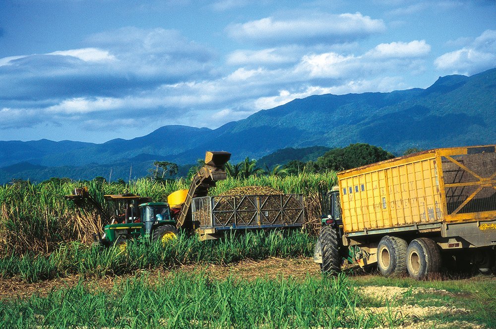
Cane harvesting near Innisfail. (Image: Tourism and Events Queensland)
This return figure-eight loop from Innisfail takes in a mix of sugarcane country, rainforest and some of the region’s pristine coastline.
Kicking off in Innisfail, you head south-west, through South Johnstone, before continuing further south to Mena Creek, with Japoon National Park – and Mena Creek Falls – nearby underneath the shadow of the rainforest-clad mountains of the Table Top Range. From Mena Creek it is another 10km south to Old Silkwood, then east 9km to Silkwood, before returning to the Bruce Highway and heading north back to Innisfail. Just before Innisfail is a worthwhile detour: the Australian Sugar Heritage Centre at Mourilyan showcases this import industry and its history.
From Innisfail, continue north on the Bruce to Babinda (often awarded the title of Australia’s wettest town, owing to its annual rainfall of more than 4000mm) and spend some time exploring nearby Wooroonooran National Park before turning south once again and heading to Flying Fish Point, right on the coast and the perfect place to spend the last night of this loop. For keen anglers, Flying Fish Point lives up to its name, offering some of the best beach- and estuary-based fishing in this area.
4. Mareeba–Chillagoe Loop
Distance: 583km
Time: 5-6 days
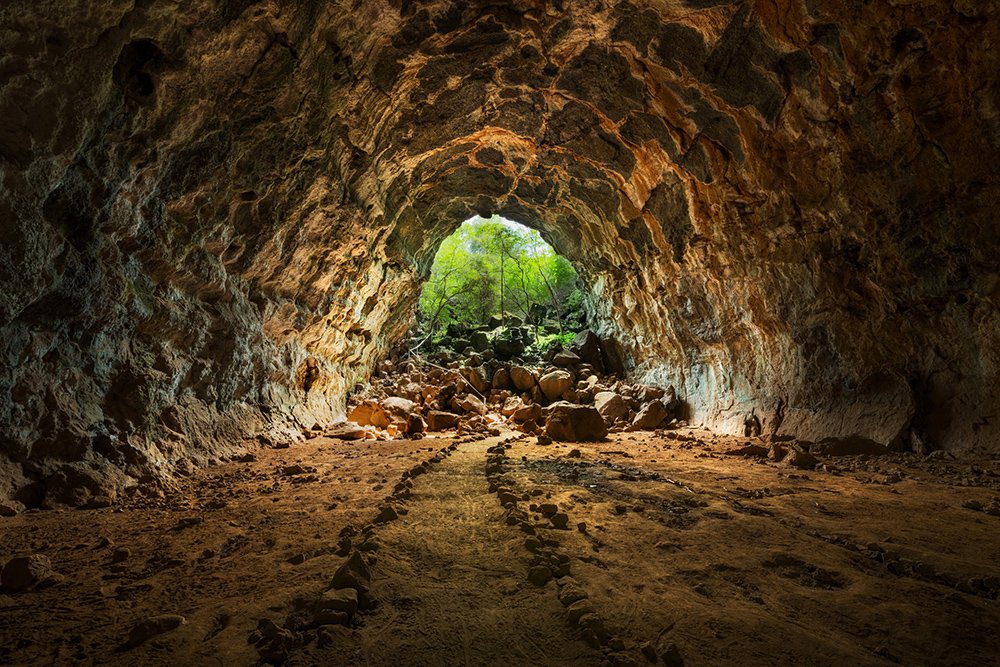
Inside one of the Undara lava tubes. (Image: Drew Hopper/AG)
This return loop will take you through TNQ’s amazingly varied landscape as you travel from the rich, dense rainforests near Mareeba in the Atherton Tableland, to the expanse of the savannah grasslands further west and its underground secrets.
The road is a mix of sealed and dirt but nothing too difficult for regular vehicles (4WD/SUV not essential). You drive west to begin with, following the Burke Developmental Road to reach Chillagoe-Mungana Caves National Park. Here you’ll find the amazing limestone caves. You can join a ranger-guided tour or do a self-guided tour (take a torch), with The Archways (30 minutes) tour the most accessible/easy. From Chillagoe you retrace your steps to Almaden and then drive south via Almaden and Lyndbrook until you reach the Gulf Developmental Road, 14km east of Mount Surprise. Spend a day at Undara Volcanic National Park to see the lava tubes before you start the return loop north-east, via the Gulf Development Road, then on to the Kennedy Highway and north to Mareeba.
Accommodation on this route ranges from national parks bush camps through to caravan parks and resorts.
5. Tully–Mission Beach
Distance: 218km
Time: 3-4 days

Whitewater rafters on the Tully River. (Image: Drew Hopper/AG)
This is a real there-and-back-again trip, looping west out of Tully to check out the magnificent Tully Gorge National Park (and the gorge itself) to the west.
The gorge is reached via a 41km journey that hugs the national park’s southern border, with the Tully River flowing nearby. There is a great camping and day-use area out here (with great facilities and a cool short walk – the Butterfly Loop), and brilliant lookouts right near the camping ground and 5.5km further along at Cardstone Weir Lookout. After overnighting at the camping ground (tip: take a cool dip in the Tully River before you leave), you return via the same road to Tully, then drive south to Murrigal. From here head south to the Upper Murray Road, then the Middle Murray Road, before arriving at the Murray Falls camping and day-use area in Girramay National Park. There’s a nice short walk here – the Yalgay Ginja Bulumi Walk – and some great swimming holes to cool off in. From Murray Falls, it is another return drive to Tully, before continuing north along the Bruce Highway to El Arish and turning east towards the coast and Mission Beach.
Accommodation along this route ranges from well set up national park camping grounds, through to luxurious resorts at Mission Beach.

