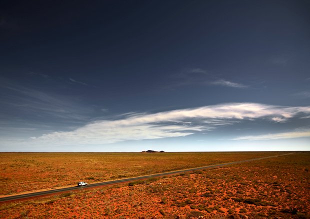
This image, of a lone 4WD skating along the North West Coastal Highway, in many ways sums up The Pilbara Project. It is about exploring the unexpected beauty of an isolated, complex region; digging deeper than common perception and looking at ways of capturing its importance and revealing it to the wider world.
The Burrup Peninsula, stretching out from Dampier, provided stunning fodder for The Pilbara Project photographers, who explored the terrain on foot and from the air. The Burrup is also significant to many local Indigenous communities and is believed to be the place from which ancestral life emerged.
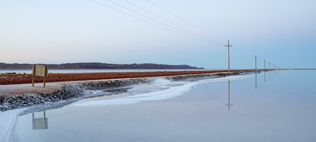
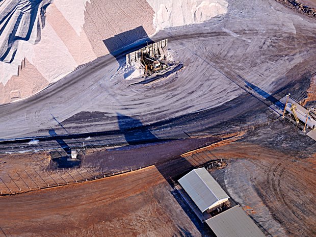
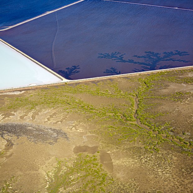
The road connecting coastal Dampier to Karratha is lined with man-made salt pans and salt is among the many natural resource industries that has made the Pilbara a key driver of the nation’s economic success. More akin to glassy ice than arid outback, this photograph captures an unexpected side of the Pilbara.
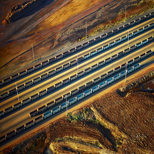
The Pilbara is threaded with railway lines connecting different mining operations. Privately owned, the railway lines transport long chains of carriages holding mostly iron ore. In this photograph Peter Eastway has captured a chain of empty carriages outside of Port Hedland, waiting to return inland to the mines.
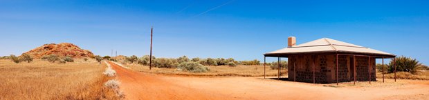
This historic building is typical of those found around Cossack, a picturesque ghost town on the mouth of the Harding River, Western Australia. A former pearling hub and pastoral port, Cossack became a ghost town in the 1950s, the eventual result of the migration of the pearling industry to Broome and the need for bigger ports to accommodate bigger ships.
Flying over the Port Hedland region in Western Australia’s Pilbara region reveals an organic maze of swirling mangroves and tributaries, a marked contrast to the graphic shapes of the area’s industrial operations. Peter Eastway says of his photograph: ‘What’s remarkable is that this image was taken just a couple of kilometres away from the image of the railway tracks.’
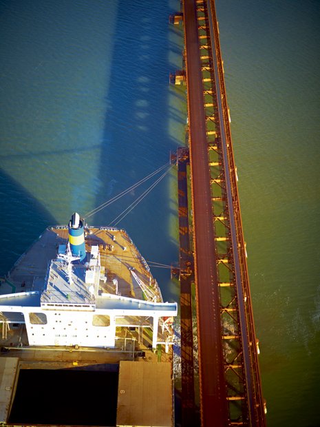
Port Hedland, at the top of the Pilbara, is where The Pilbara Project began. Like many communities in the region, this industrial town has a pastoral past. Port Hedland is now one of the largest ports in Australia and is the gateway connecting the country’s resource exports to China and the wider world. The port is like a busy world unto itself, full of intimidatingly large ships which not only fill the port but can often been seen queued for miles in open ocean.
Buster’s submarine fuel tank hides a secret only known to locals- its interior walls are crowded with hand-drawn fairytale and cartoon characters. The drawings, recreating the worlds of the likes of C.S. Lewis and Walt Disney are, according to local myth, courtesy of the German mother of a young family who moved into the tank sometime in the 20th Century. A caravan was set-up beside the tank but the family lived inside, lighting the tank with candles.
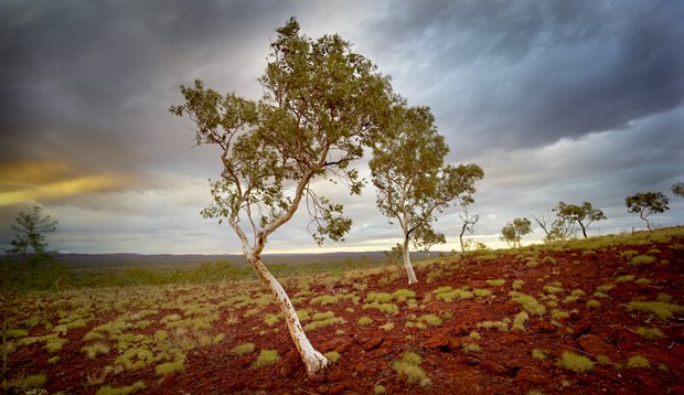
The furthermost reaches of the Pilbara, extending from Newman to the interior border of Western Australia, occupy true desert country. This image, of a svelte ghost gum common to the region, was taken in Rudall River National Park.
This is Martu country, the loosely collective name for the Indigenous custodians of this region, whose communities are sprinkled throughout what is extremely isolated terrain. Artists from local Indigenous art centre Martumili Artists hosted The Pilbara Project photographers and took them to communities and places not normally accessible to outsiders.
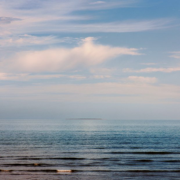
Direction Island, off the shores of Onslow, appears a mere slither of land in Tony Hewitt’s photograph, barely distinct from the line connecting sky to ocean. Hewitt’s photographs of this pocket of the Pilbara, taken late Spring in October 2010, show a subtle place that is visually distinct from other parts of the Pilbara.
This aerial shot of Western Desert country captures the immense drama of this most isolated part of the Pilbara. The photographers were captivated and moved by these tracts of land, which they visited in May 2010. It is a land which is capacious yet intricate in detail.
William L. Fox, an American writer and curator who travelled with the group commented: “No matter how remotely we think we’re camped, we’re embedded in a web of movement around the planet, be it birds or art or ore.”
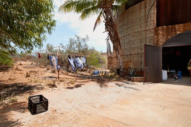
Onslow is home to four massive marine fuel tanks, built during World War II. Onslow itself was bombed during the war. These days the tanks function as cyclone shelters; this one is 80 metres round, 25m across, 9m high and sits on private property owned by Onslow local Robert ‘Buster’ McDonald and his brother.
Resembling powdery snow, the Pilbara’s salt industry is also prevalent around the northern Pilbara town of Port Hedland. This aerial shots show the fascinating patterns forged by the daily activities of local salt operations.
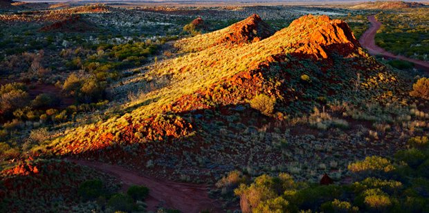
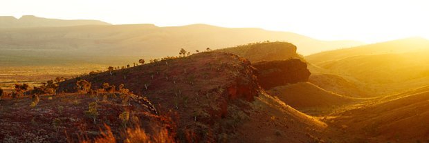
The photographer described this early morning scene as ‘a secret location just out of Tom Price.’ Tom Price is an established iron ore mining community in the interior of the Pilbara and this ‘secret location’ is part of the undulating Hamersley Ranges. The Pilbara’s inland is dominated by cascading, dramatic ranges like this and has long inspired photographers and artists.
Onslow is a petite Coral Coast town lying at the very bottom of the Pilbara. This streetscape captures something quintessentially Western Australian about the town. The West Coast Eagles flag, the flowering Bougainvillea, the travel-weary 4WD, the palm trees and elevated houses are all common in North Western towns. Established in the late 1880s, Onslow’s heritage includes wool export, pearling and more recently, tourism.
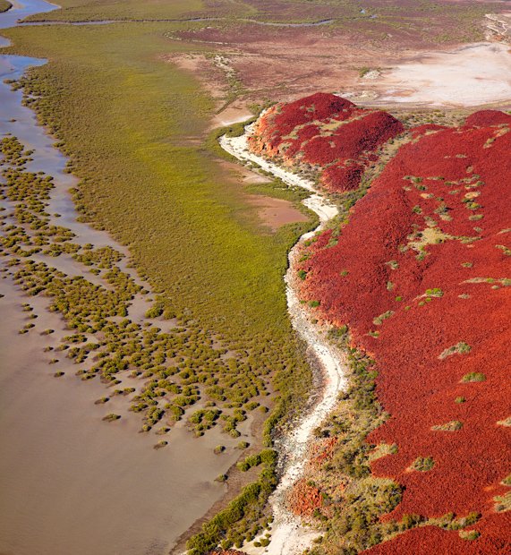
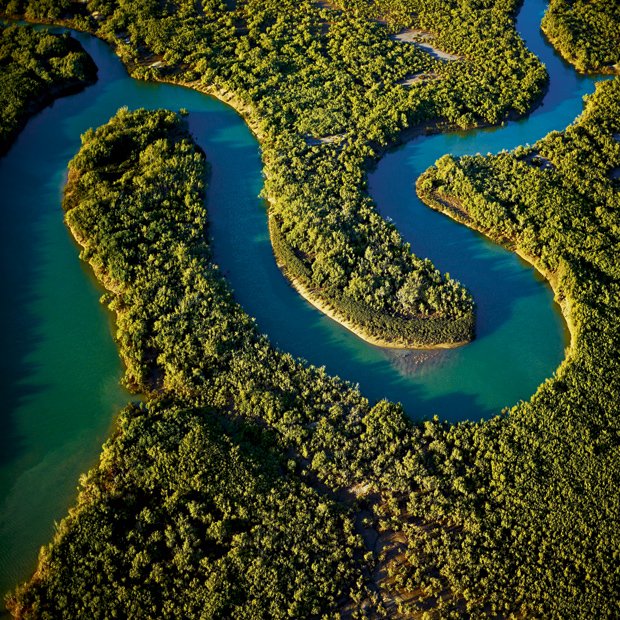
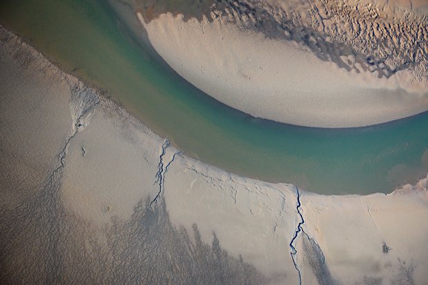
Also one of three limited edition covers of the Pilbara Project book Field Notes and Photographs Collected over 2010, this aerial shot of a natural waterway running along the Burrup Peninsula, on the Pilbara’s middle coast, reveals a delicacy of colour and texture not usually associated with this semi-desert region.
The photographers spent a lot of time around the Burrup Peninsula, part of the Dampier Archipelago, during their seasonal journeys in the making of the first Pilbara Project exhibition,52 Weeks On.
Speaking about the experience of aerial photography from chartered helicopters and Cessna 172s, photographer Les Walking commented: “This restricted point-of-view was a powerful metaphor for our myopic engagement with this land, its settlement, industry and purpose.”
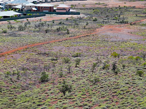
Karratha, inland from the central Pilbara coast, is a sprawling town hemmed in by reddened outback flats. Yet on closer inspection the red gives way to the subdued greens of Spinifex, the pink and hazy blue of miniature wildflowers and the lavender grey of seeded shrubs and bracken.
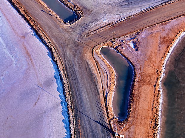
This image offers an aerial view of the salt flats throughout the Karratha-Dampier area, the salt harvested from seawater. The colour of the salt alters through its various stages of evaporation, graduating from translucent sapphire blue to opaque turquoise and eventually to white.
This photo captures the complex, interdependent relationship between industry and the natural environment in the Pilbara: the tree-like lines of natural coastal tributaries feather through into the man-made salt pans.