Barrington Tops: the bushwalker’s park
“We’re in a moment in time here,” says Harry Creamer of the NSW National Parks and Wildlife Service (NPWS), his breath billowing in front of him. “In this forest you get an experience that’s so far removed from any urban situation – you’re faced with the temperature, the altitude and the moisture. The stillness and majesty of it speaks volumes about the power of nature, and that’s why it’s so important to have these places.”
Centred on the Barrington massif – a series of crests forming part of the Mount Royal Range – Barrington Tops NP is dominated by a 22km plateau that falls away steeply to the east, west and south. The high country, covered in snow-gum woodland and subalpine swamps, extends away in narrow ridgelines that drop suddenly into rugged escarpment country and numerous steep river valleys. About three-quarters of the 74,567ha park is a declared wilderness area, and more than half is part of the Gondwana Rainforests of Australia World Heritage Area. The park is home to the southernmost stands of Antarctic beech on mainland Australia, and it forms the last link in the chain of Gondwana Rainforests WHA reserves, which begin in south-eastern Queensland and spread south along the coastal escarpment of north-eastern New South Wales.
“About 50 reserves make up the Gondwana Rainforests of Australia, and Barrington Tops is a standout for sure,” says Harry, who has worked in national parks since the 1970s but only recently joined Peter and the team in the Hunter Region. He explains that four types of rainforest make up the Gondwana Rainforests, and that Barrington Tops features them all: dry, subtropical, cool temperate and warm temperate. Peter, who has been a ranger in the Hunter Region for 11 years, says that in addition to the ancient rainforests, what makes Barrington unique is its dramatic range in altitude. This has led to a diversity of wildlife living side by side in a wide variety of ecosystems. “It’s such an interesting area, environmentally and ecologically,” Peter tells me. “From the lowest point in the park at Jerusalem Creek, to the highest at Brumlow Top, there’s about a 1300m difference in altitude so you get subtropical rainforests, snow-gum country, and everything in between.”
Barrington Tops: so many experiences in one place
Although Gloucester Tops doesn’t reach the same altitude as Brumlow Top – which forms part of the Barrington plateau and rises to 1586m – it’s one of the best areas in the park to see a snapshot of these environments. From the entrance gate at the park’s eastern edge, an 18km unsealed road climbs steeply through vine-tangled rainforest to the plateau, which rises up to about 1300m. Because of the abrupt ascent, the temperature difference between the Tops and the Gloucester River below can be 10ºC. “This is the place that I always tell people to visit because you get so many experiences all in one spot,” Peter says.
The track he’s leading us down is a short offshoot from the Link Trail, a 17km walk across the ridge-line connecting Gloucester Tops to the Barrington Tops plateau. As we continue to head down the narrow track, stepping over snow-grass tufts, we glimpse the back wall of a corrugated-iron hut. It’s nestled under the eucalypt canopy, and is barely visible through the mist. “You really need to know where this place is to utilise it, because it’s not on most maps,” Peter says. He played a major role in the recent restoration of this old bushwalkers’ hut – known as Munro Hut – and pressed for a sign detailing its history.
Streaked with rust and supported by moss-covered beams that were cut on site 60 years ago, Munro Hut has taken on the colours of the bush. “It was named after ‘Darby’ Munro who was one of the founding members of the Newcastle Bushwalking Club,” Peter says as he swings open the door. A large open fireplace dominates the modest hut. A stack of dry firewood and kindling is bundled into one corner, beside a simple log bench. Three-tiered wooden bunks occupy two of the corrugated walls and there’s a table pressed under a large window.
“When this place was built by club members in the ’60s, all the materials were carried in by hand,” Peter says as he reaches for a rusted red tin. He prises it open and pulls out an A4 notebook with a drawing of a quoll taped to its cover. It’s the Newcastle Bushwalking Club’s register for this hut. Inside it, walkers have inked messages and recorded tidbits of useful information such as birds spotted, locations for fresh water and any maintenance carried out during their stay.
I flick to the latest entry, dated 23 June. The hut seems completely secluded, so it’s strange to discover that only two months earlier walkers had camped here. A three-week-old newspaper reveals more recent visitors. “The hut’s regularly used by members,” Peter tells me as he points to an interesting logbook entry, dated Anzac Day 2011.
“We came up for the day to see the sign out the front of the hut,” it reads. “I stood outside with a cup of tea and thought about how many times I’ve seen Dad stand in the same spot… I wish he was here now.” The scrawled handwriting belongs to Alan Munro, Darby’s son. His entry in the logbook continues with a message for his father: “I would give 100 days for you to have one more, to take my kids into the bush just like you did with me before.”
Barrington Tops a source of inspiration
Barrington Tops has been a source of inspiration for bushwalkers, conservationists and visionaries for many years. “There was a push in the 1920s…to turn Barrington Tops into the ‘Kosciuszko of the North’,” Peter says as we drive down from the plateau the next afternoon. “There were plans for hotels and ski fields, ornamental lakes and landing strips, and talk of damming rivers and having hydro schemes. They were big ideas, but conservation won in the end.”
The sun is sinking below the escarpment behind us as we snake out of the national park and through the paddocks that cover the foothills. Brightly coloured king parrots flit above us and eastern grey kangaroos dart in and out of sight amid clumps of trees. When we reach Copeland, a small township about 25km east of Barrington Tops NP, Peter pulls into the front yard of local historian Robin Budge. Originally from Brisbane, Robin moved here 15 years ago, after he and his wife fell in love with the area during a weekend sojourn in an old mining cottage. “I’ve always loved history,” he tells me as we walk into a small patch of rainforest just behind his house.
“Of course, every place has a lot of interesting history but here it’s everywhere, right down to this actual block of land,” he says. “Where your car is parked just over there on that bit of green, that’s where the biggest pub in Copeland existed during the gold-rush days.”
He takes us into a two-storey steel shed, which doubles as his library and office. It is a trove of artefacts, books, papers and microfilm reels. Newspaper cuttings are spread in organised piles around his typewriter alongside tidy rows of printed pages. Downstairs is a collection of glass and ceramic bottles, some 150 years old. They were excavated by “a couple of mad-keen bottle collectors” just a few years ago. Each is a different shape or colour; some are frosted, and some still cradle their glass marbles, which were used as stoppers in the place of corks.
We settle into a couple of armchairs on Robin’s front verandah. Over coffee he weaves together a patchwork of stories about Barrington Tops, extracting fact from myth. He tells us of 19th century surveying expeditions, summer-grazing efforts, cedar-getting operations and goldmining ventures. He explains that prior to the 1920s, first-hand knowledge of the Tops was limited to graziers, foresters and a handful of adept bushwalkers and naturalists. At that time, all the tracks that led through the wilderness skirting the plateau were navigated on foot or horseback. The terrain was rough and the climate unforgiving.
“Apart from being a place where you carted cattle up to during desperate dry seasons, it was just too tough,” he says. “In the 1920s, motor cars started getting better and that was really the beginning of the tourism boom of the Barrington Tops.” He mentions the early 20th-century vision to create a mountain retreat on the Barrington Tops plateau that would rival those of Kosciuszko and Katoomba. “Any dreams of developing the Tops slowly faded in the face of determined opposition by conservationists,” he says. “I think they were right. Barrington Tops is too fragile and too isolated.”
In their day, bushwalkers such as Darby Munro and Selby Alley, another founding member of the Newcastle Bushwalking Club, were instrumental in keeping development out. In 1947 Selby co-wrote a letter to the Newcastle Morning Herald as part of a larger public plea to convince the NSW government to preserve the region’s subalpine environments. “For years we, and hundreds like us, have walked and camped in the solitude of the Barrington plateau,” he wrote. “Its charm lies in its remoteness and solitude, its calm peace and direction-confounding mists. The coming of roads and boarding houses must inevitably destroy it. At present we can delight in the beauty of the slopes above its swamps, yellow in summer with thousands of daisies; and the winter majesty of the silent gums, gnarled and bent under their age-long burdens. If the proposed development of this area follows the trend of exploitation of other places, the charm…will be lost for all time.”
Their passion for Barrington Tops and the public support they generated played a role in the NSW government’s decision to reserve two small areas at Gloucester Tops and in the Williams River region in 1959. Ten years later the national park was formed when about 13,831ha on and around the Barrington Tops plateau were gazetted. In the decades that followed, the park progressively grew to the 74,567ha it is today – one-third the size of the ACT.

Barrington tops off the beaten track
Road access into Barrington Tops has always been limited, so the remoteness and solitude Selby revelled in can still be experienced today. Soon after the national park was declared, the Barrington Tops Forest Road was built across its northern end, to allow the NSW Forestry Commission access to timber resources in the adjoining state forest. It’s an unsealed road that rises steeply onto the Barrington Tops plateau from Gloucester in the east, and drops down to Scone in the west. Although it provides all-weather access to the plateau and is a platform from which visitors can explore the handful of walking and four-wheel-drive tracks that wind about on the plateau, it remains the only through-road in the park.
“Lots of people go through the Blue Mountains because the road goes through, whereas Barrington Tops is something most people drive around on the New England and Pacific highways,” Ken Rubeli tells me as he gets stuck into a pie at the Barrington Bakers in Dungog, about 20km to the south of the park. Ken did a bushwalk here in 1987 and promptly moved to the area a year later. Today he manages Wangat Lodge, an ecotourism business situated just outside the park’s southern boundary on the Wangat River. “There’s no through road [in the park],” he says, “but you wouldn’t want one either.”
Visitors can get into the park’s southern end via Dungog at the Jerusalem Creek and Williams River areas. The eastern edge can be reached from Gloucester, via the Gloucester Tops Road, and the plateau can be navigated via the Barrington Tops Forest Road and the Barrington Trail, which is a 4WD track that heads towards the plateau’s southern edge but is closed from June-October. Apart from that, it’s a vast and inaccessible expanse. “In some ways it feels like a big empty space because people have been on the Tops and in the foothills, but those places in between, the heads of the river valleys and the wilderness areas, have had very little modern presence in them,” Ken says.
The park’s remoteness, but also its proximity to towns such as Dungog, “where you can get a cup of coffee and a pie, or hop on a train and be in Sydney in about three hours” appeals to Ken. He tells me that on a recent eight-day walk into the Wangat River valley, he really felt the seclusion of the wilderness. “When you’re out there for days on end you lose all sense of time; it could be today or you could be in the forest 1000 years ago; it feels like you’re in another world completely.”
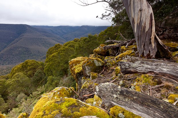
Barrington’s spectacular scenery
I understand what Ken means as I walk the Jerusalem Creek Track, in the south-eastern pocket of the park, with Anthony Signor, Barrington Tops area manager for the NPWS. “In this region visitors can see some fairly spectacular scenery and get that feeling of being in a remote wilderness area without necessarily venturing off the beaten track or too far out of their comfort zone, unless they want to,” he says.
Anthony enjoys finding the balance between protecting the park’s ecological and cultural values and providing a range of attractions for visitors. As he leads us past towering tallowwoods, Sydney blue gums and grey gums, dappled early afternoon sunlight filters through the canopy. Overhead, in the adjoining rainforest, elkhorns and other epiphytes are cradled between trunks and branches, adding additional bursts of green to the lichen-mottled trees. “I’ve always had a passion for the Barrington Tops,” he says. “It’s that interaction between altitude, the landscape and the soil structures that makes the landscape here so fascinating and so spectacular.”
Jerusalem Creek Falls thunders off to the side, accompanied by a chorus of croaking frogs and the cries of glossy black cockatoos, a threatened species that has a stronghold within the park. It’s also interesting in terms of confluence of ecosystems, he says: “You’ve got that interesting influence of a lot of western species coming up on the western slopes, and then there’s the coastal influence in the east. As well as that, a lot of species of both flora and fauna have their southernmost occurrences here, so it’s a real melting pot.”
Anthony points out examples of pepperbush and native tamarind. He explains that Barrington Tops sits on the boundaries of Biripi, Worimi, Geawegal, Wonaruah and Ungooroo land and that traditionally these species would have been used for food. “It’s likely that Aboriginal people used the Barrington Tops seasonally, visiting a combination of the subtropical rainforests, with their bounty of bush foods and medicines, and the more open country, where there’s just so many macropods,” he says.
Despite the familiar story of land taken during early European settlement and an ensuing history of conflict and massacre, many Aboriginal people retain a deep-felt connection to the region. Senior field officer Ken Eveleigh tells me that his ancestors lived just outside of Gloucester, so for him, working in the national park is about protecting both the environment and his family’s long history with the land. “We were originally the custodians of the land and now we are again, which is excellent,” he says. “I get to walk back where our ancestors walked and it’s that connection to the country that I really like.”
Anthony agrees that Aboriginal heritage is a significant feature of the park today: “We consult local communities and when we work on our management plans we meet with councils and community elders… There are a number of Aboriginal sites that we protect, and they’re very important for the cultural heritage of the park.”
ON a cold friday morning, Peter leads me once more onto the Barrington Tops plateau. He introduces me to Dave Brown, who works with the NPWS in the Upper Hunter Region, which manages the western third of the park, covering half of the plateau. From Thunderbolts Lookout we look due south and take in a panorama of untamed wilderness. The steep eastern wall of the plateau stands sentry beyond, with ridgelines extending from it like fingers. Mist hangs heavily in the valleys and shrouds the top of the plateau, and open farmland can be seen in the distance.”You’re on top of the world,” Dave says. “It’s a magic spot.”
All morning sleet and snow have been falling, and a thick blanket of fog covers the gun-metal grey branches of black sallies and the gnarled trunks of snow gums. We enjoy the warmth of a shelter before a 2.8km walk around the edge of Polblue Swamp, one of the montane peatlands that dot the plateau and are home to an endangered population of broad-toothed rats. “It’s a very fragile peat moss that slowly shifts into a soil structure,” Dave says. “Micro-organisms feed off each other and work their way through it, so there’s a balance in the processes… And there are synergies with a dump of snow that allows the vegetation above to die off and feed the peat below, so all the cycles that it goes through are interconnected.”
Dave’s enthusiasm is compelling. He has worked for the NPWS for 32 years, but has spent the past 15 living in Scone and making regular trips up to the Barrington Tops plateau. For him, the variety of ecosystems and visitor experiences to be had on the plateau are exciting. “It really is an amazing bit of country, as you come up onto the plateau, it’s like walking through a door into a different world,” he says.
As the last of the day’s light fades, Dave drives us through the Dingo Gate at the western edge of the plateau. The weather has closed in, but the landscape has retained its allure. “From here, on a good day, you see wedgies fly right past,” he says, as we stare out into the wall of white. “They pick up the updraft and float up the face there where it drops away so steeply. It’s amazing to watch them in the afternoon, when the sun sets in the distance and you get that depth of vision that leads your eye way back to the west.”
RELATED STORIES