5 times drone footage exposed environmental destruction
THE ADVENT OF unmanned aerial vehicles, more commonly known as drones, has given environmental activists the ability to expose large-scale environmental destruction, particularly in the forestry, agricultural and mining sectors.
Previously, this kind of large-scale destruction was reported in figures, unfathomable to the average reader, but now drone footage has the capacity to show a complete picture of the degradation happening in hard-to-access areas.
Use of drones by environmental and animal activist groups is a hotly debated topic within the legal world. Currently, the New South Wales Legislative Council is conducting an inquiry into the extent of protection for landowners from unauthorised filming or surveillance.
Here, we look at five cases of environmental destruction in Australia that were captured through the use of drone footage and given to journalists to publish.
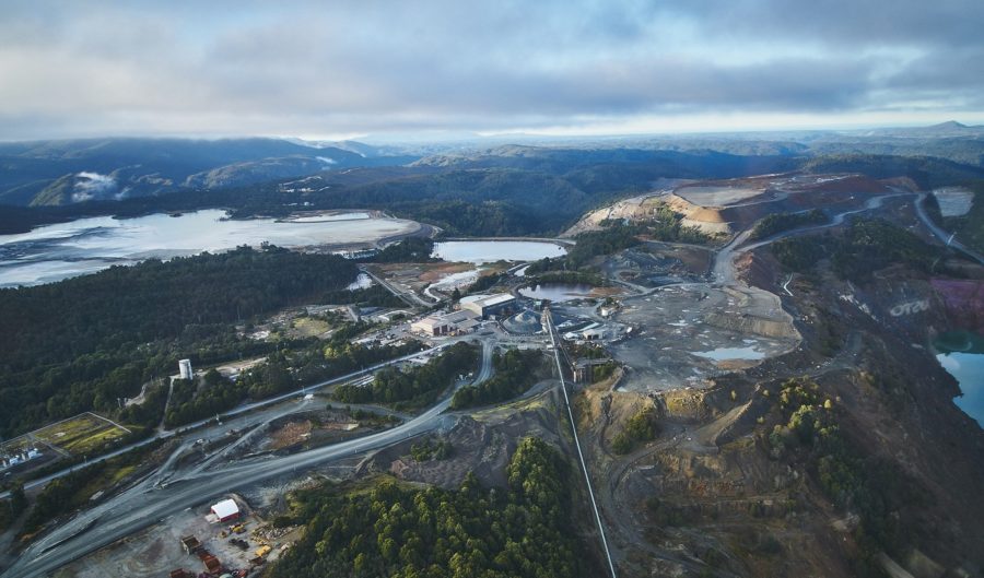
1. Logging in the Tarkine, Tasmania
The Tarkine, located in the north-west of Tasmania, is a 4500 sq.km temperate rainforest home to endangered species, Gondwanan heritage and sacred Aboriginal sites. For decades, environmental activists have campaigned to have the area listed as a World Heritage Site.
In February 2018, the Bob Brown Foundation (BBF) released drone footage of logging activities in the Rapid River area where ancient forest had been cleared. According to the BBF, the trees were being used for wood chips to be sent to logging company Ta Ann, in Borneo.
The footage was then used in a short film about protecting the Tarkine made by outdoor clothing company Patagonia in association with the BBF.
2. Illegal drilling in the Great Artesian Basin, Queensland
The Great Artesian Basin, located in Queensland and spanning 1,700,000 sq.km, is the proposed site for water extraction for the controversial Adani coal mine, which activists argue will drive up carbon emissions, threaten endangered species and pollute the Great Barrier Reef.
This September, environmental group Coast and Country released drone footage that demonstrated Adani had “illegally” fast-tracked its mining operations, including clearing vegetation, constructing roads and putting in underground infrastructure.
The footage was published by ABC News, who reported that an official investigation had been launched by the Queensland environment department.
Adani groundwater bores investigated amid claims they were sunk without approvalhttps://t.co/KRm7rK2Mzg pic.twitter.com/wou35YmSXb
— ABC Brisbane (@abcbrisbane) September 11, 2018
3. Land clearing in the Great Barrier Reef catchment, Queensland
Great Barrier Reef catchments – areas located adjacent to the GBR World Heritage Area – provide an important function, preventing sediment run-off streaming into the Reef. Land clearing in or close to these catchments has been subject to debate.
In May 2018, the Wilderness Society captured drone footage of 60 ha of forest close to a Great Barrier Reef catchment that had been “illegally” cleared. According to the society, the area just south-west of Cairns, was home to threatened species and the clearing had the potential to degrade the water quality of the reef.
The previous year, the society launched a crowd-funding campaign to help buy a fleet of drones to film land-clearing across Australia, specifically in Australia’s three most aggressive land-clearing states – NSW, WA and QLD – to expose the scale of deforestation to the public.
4. Severe drought, New South Wales
The eastern side of Australia is currently gripped by drought due to low rainfall that made this last winter the eighth-driest on record. In some parts of New South Wales and Queensland, it’s been labelled the worst drought in a hundred years, with farmers losing much of their livestock and crops.
Drone footage has captured the extreme weather, delivering never-before-seen images of the impact on the Australian landscape and farmers. One particular video of a large herd of cattle swarming a water truck in drought-affected NSW went viral. Another drone image by photographer David Gray showed a dried-up, intensely cracked dam.
David and fellow photographer Brock Mitchell have been travelling through drought-affected NSW capturing images of farmers and the land from above. Many have commented that the images look a lot like abstract paintings.
5. Land clearing by farmers, Queensland
Land clearing in Queensland has remained a point of great contention between environmentalists and farmers. It’s been estimated that an area bigger than 1000 rugby fields is cleared every day, with an overall 395,000 ha of regrowth and old growth vegetation cleared in 2015 and 2016.
In 2016, the World Wildlife Fund released drone footage of thousands of hectares of land clearing that had occurred on a property in central Queensland, which showed nothing but immature trees, sparsely scattered.
A report published by the Guardian with the accompanying footage outraged the public and brought into question the “relaxation” of land clearing laws in the state back in 2012.

