A complete guide to Adaminaby, NSW

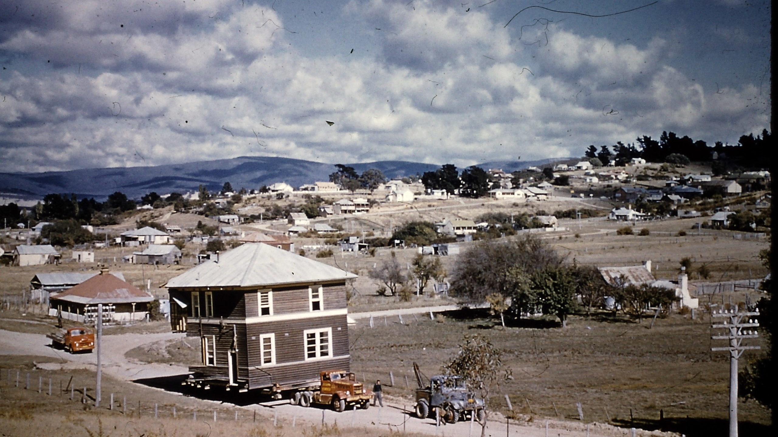
Adaminaby is both a historic and modern town. The initial European settlement in that location was a stopover for gold prospectors making their way to the rich goldfields at Kiandra. From 1956 to 1957, when the waters of Lake Eucumbene began rising due to the vast Snowy Mountains Hydro-electric Scheme, many of the town’s significant buildings (notably its churches) were moved 8km to Adaminaby’s present site.
Consequently, the modern town and its newer buildings date from the early 1960s. Essentially it’s a carefully planned village, purpose-built to house former residents who’d been displaced by the rising waters of Lake Eucumbene.
It was designed so the main road, the Snowy Mountains Highway, didn’t run through the town. An interesting rectangular retail precinct modelled on a wide plaza became the town centre. There was extensive planting of trees in streets that were contoured, rather than laid out in the more common grid pattern, and all blocks were created with 1960s features, including reticulated electricity, water, sewerage, kerbing and guttering.
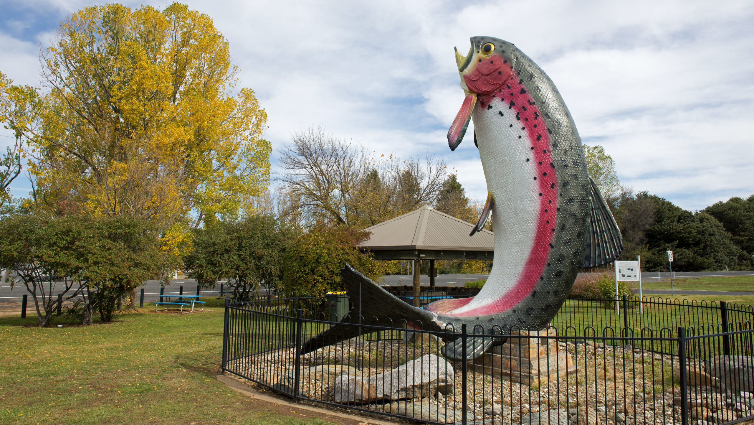
New buildings have since been built on the shores of Lake Eucumbene and the area has become known as one of the finest for trout fishing in Australia, which explains the Big Trout landmark in the town.
Adaminaby is a typical Monaro Plain town – cool in summer, colourful in autumn, snowy in winter, and with a reputation as an ideal place for bushwalking, skiing and horseriding.
Location:
Adaminaby is 450km south-west of Sydney via Canberra and Cooma, 539km from Sydney via the Hume Highway and Tumut and 52km north-west of Cooma. It is 1021m above sea level.
Origin of Name:
When Europeans settled the Monaro
Plain in the 1840s, one of the properties was named the “Adumindumee” run, which was probably a corruption of a Ngarigo word meaning either “a camping or resting place” or “place of springs”. By 1861 the village was surveyed and named Seymour, but on 9 October 1886, it was renamed Adaminaby to avoid confusion with the town of Seymour in Victoria.
Visitor Information :
There is no formal visitor centre but local shops, notably the Museum Op Shop, will help with information. The closest official centre is the Cooma Visitors Centre, 119 Sharp Street, Cooma.
Useful Websites:
visitnsw.com/destinations/snowy-mountains/cooma-area/adaminaby
Places of interest
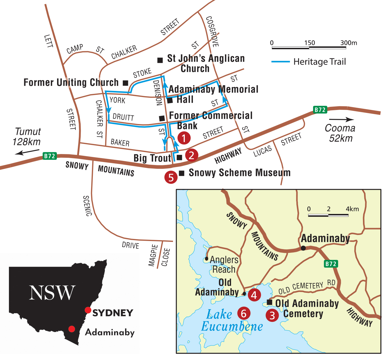
1. Adaminaby Heritage Trail
This provides a great overview of the town and its history. It’s a self-guided walk and drive, beginning at the Big Trout; the walk takes about 40 minutes and tells the town’s story through storyboards. Of particular interest are: St John’s Anglican Church, which was originally built in 1906 and relocated in 1956, and St Andrew’s Church (now a private residence, formerly the Uniting church and, before that, the Presbyterian church), which was built in 1888 and also moved in 1956. The trail also takes in Old Adaminaby, including the old town’s cemetery, on a 20-minute return drive.
2. The Big Trout
This 10m-high rainbow trout, just off the Snowy Mountains Highway, was designed and built by local artist and angler Andy Lomnici from steel, mesh and fibreglass, using a frozen trout as a model. When the sculpture was unveiled in 1973, Adaminaby was proclaimed Australia’s Trout Capital.
3. Old Adaminaby Cemetery
Located 14km south-west of Adaminaby via the Snowy Mountains Highway and Old Cemetery Road, this graveyard was established in 1863 and is a unique record of the early history. It’s 5m above the lake’s high-water mark.
4. Historic Buildings in Old Adaminaby
Located 9km from new Adaminaby are the remnants of Old Adaminaby – those buildings that were saved because they were built above what became Lake Eucumbene’s high-water mark. Fisher’s chalets and holiday houses have recently been built on the lake’s foreshores, while Rainbow Pines Tourist Caravan Park has become a magnet for anglers and holidaymakers. But five original buildings are left where they originally stood, among them the original school building and the schoolmaster’s residence, now used by Rainbow Pines as their office and accommodation, respectively, and the Methodist church, dating from about 1896, which is surrounded by pleasant picnic grounds and offers fine views across the lake. The lake, when at capacity, reaches the church steps.
5. Snowy Scheme Museum
The museum, at 5199 Snowy Mountains Highway, opens 10am–2pm on Saturdays and Sundays. It has a photographic collection, as well as bulldozers, shovels, trucks and a snow plough, all of which were used on the Snowy Scheme.
6. Trout Fishing
Lake Eucumbene and local rivers and creeks are well stocked with both brown and rainbow trout. Caught specimens have weighed as much as 6kg. This makes the area ideal for freshwater anglers, who catch the the trout by fly, spinner, trolling and bait fishing. See: rainbowpines.com.au/
History
Before European settlement the area around Adaminaby was occupied by the Ngarigo First Nations people. During summer months the Wiradjuri people from the west and the Yuin from the east travelled to the district to feast on bogong moths.
By the 1830s pastoralists began moving sheep to the area during the summer months.
In 1848 Henry Cosgrove and Charles York applied for 6734ha, which they called the “Adumindumee” run.
In 1859 gold was discovered at Kiandra, and in 1860 discoveries were made along the Eucumbene River. Prospectors, walking from Cooma to Kiandra, stopped at what is now Adaminaby.
In 1861 the village was officially surveyed and named Seymour.
On 9 October 1886 it was renamed Adaminaby.
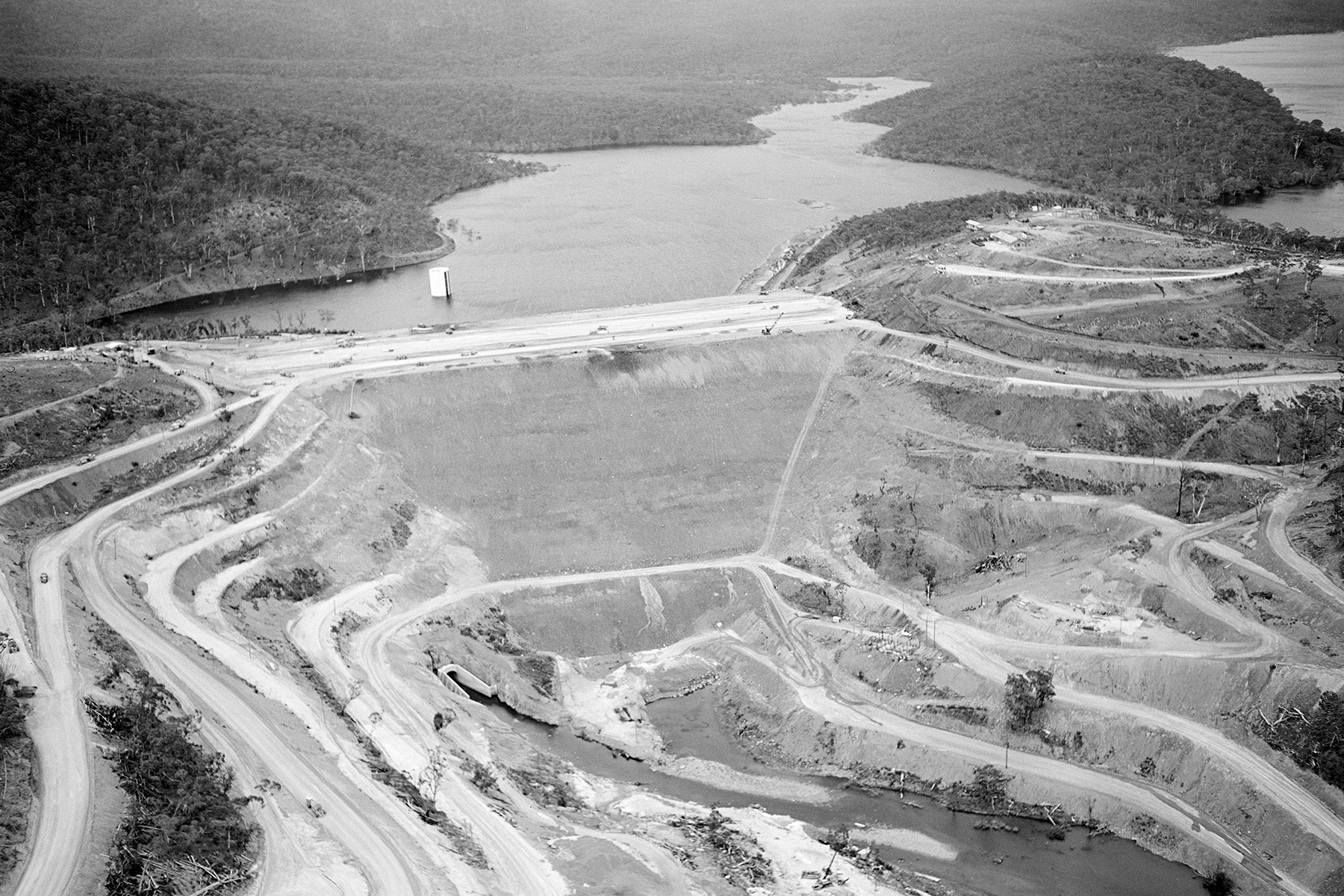
In 1949 the Snowy Mountains Scheme commenced. The creation of Lake Eucumbene meant the old town would be inundated.
From 1956 to ’57 the old town was moved to its present site to make way for the rising waters of Lake Eucumbene.
During the long drought early in the 21st century, much of the old town was exposed as Lake Eucumbene’s level dropped.


