The South Coast Track is a bushwalker’s dream
Deadmans Bay was surely named by a bushwalker. This tiny notch in Tasmania’s south coast is wrapped across the toes of the infamous Ironbound Range. Walkers coming from the west on the South Coast Track filter down from the range’s tangled slopes and assemble like avalanche debris in camp on the bay’s shores. By the time they reach here, at the end of one of the most notorious days of walking in Tasmania, many feel as though they could almost be that dead man or woman.
“I felt like I was knitting… under, over, under, over,” one woman tells me in camp, describing the hours of acrobatics required to navigate the slippery slopes, rocks, tree roots and logs on the descent from the range. At times it’s less a bushwalk than a gymnastics routine with a backpack.
The South Coast Track has long been Tasmania’s premier multi-day coastal trail, though it’s been overshadowed in recent years by the emergence and hype of the Three Capes Track. For a pure, grounding coastal walk without the excess trimmings, however, it remains unsurpassed. There are no beaches like these on the Three Capes Track; no end-of-day swims this restorative, and no challenge quite like the Ironbounds.
I’ve come to the South Coast Track with my two teenage children, Kiri and Cooper, brought here by a years-old promise that we’d walk the track together when Kiri turned 15.
As the name on the tin suggests, the track stretches across Tasmania’s southernmost coast. It’s an 85-kilometre walk, ideally spread across seven days, and it presents two options – hike from Cockle Creek and fly back to Hobart from Melaleuca, or fly into Melaleuca and hike back to the road end at Cockle Creek. With southwest Tasmanian weather conditions fluky at best, we’ve chosen the latter, so that if we’re stranded by weather it will be in Hobart, not Melaleuca.
On cue, strong winds delay our flight, but after a few idle hours we’re in the air, the small plane blowing about like paper in the wind before skidding down onto the dirt airstrip at Melaleuca.
Other than Everest Base Camp, I can think of no other hike that starts directly from an airstrip. As we cross the runway, the kids swirl about with their arms spread wide as wings. We’re cleared for take-off.
It’s a gentle journey out to the coast, following a wide valley in classically Tasmanian button grass terrain. Bald quartzite mountains frame the way, and soon the muffled murmur of the Southern Ocean is announcing the proximity of the coast at Cox Bight.
The deepest of the incisions along the south coast, Cox Bight is a spectacular way to be introduced to these shores. Its sands are so wide and firm that planes used to drop bushwalkers off right here. The rocks at the water’s edge are as polished as marble, and it’s a beach and a walk split in two by a tongue of rock named Point Eric.
At the base of the point, we set up camp for the first night, just steps from the sand and a grandstand view of a sunset that rages through a firestorm of colours before dulling to darkness.
Re-packing on the first morning of a weeklong bushwalk is always a puzzle (what went where in which packs?) and we’re suitably slow getting away from camp. The tide is slowly rising, and by the time we hit the base of Black Cliff at Cox Bight’s end, there’s no dry way through. We can remove our boots and wade through the sea around the cliffs, or we can attempt a rock-hop worthy of a hopscotch world championship. I’m walking with teenagers, so the choice is never in doubt. Rock-hopping it is.
The South Coast Track connects nine beaches, but also includes several protracted inland sections, the longest of which begins from the eastern end of Cox Bight, where the trail turns up and over the Red Point Hills before approaching the Ironbounds across the Louisa Plains.
On a hot day, the plains are interminable. For every 10 steps we take, the campsite at their end, on the banks of the Louisa River, seems to take nine steps away from us. It’s like kayaking to an island – it just never seems to get any closer.
But there’s relief along the way, in the form of two cooling creek crossings. At Faraway Creek, we dump our packs and wade upstream to a deep pool, where the cold water is like anaesthetic. In the busy Louisa River campsite there are more swims. It’s a campsite idyll, but one with an ominous shadow; it’s here that the climb begins onto the Ironbound Range.
The campsite is full this night, with walkers heading in one direction interspersed with those heading in the other, creating a contrasting atmosphere that’s part pleasurable relief (those who’ve just crossed the Ironbounds) and part anxiety (those who must cross them the next day).
The Ironbounds are a 900m-high speed bump, so there are far bigger mountain climbs in Tasmania, but few have a reputation this large. The thing about the Ironbounds is that when you think the hard work is done, it’s just beginning. The climb is tough, but it’s the descent that’s brutal.
The crossing to Deadmans Bay, just 12km away, can take up to 10 hours, so at Louisa River the campsite stirs early. We’re almost last out of camp, and still we’re low on the slopes of the Ironbounds by the time the sun has risen.
I’ve loaded up my pack to reduce the burden on the kids, only to watch them disappear up the mountain. Even walkers I overtake are mocking me for being left behind by my children.
Hours grind by on the climb, which has three sections – a steep ascent to a ridge, a flatter path along the crest of the ridge, and then the steepest bit of all. By the final section, people are taking a few steps, stopping to suck in breaths and reluctantly continuing. It’s like walking at altitude, and yet the ocean is just a few hundred metres below us.
The climb’s top is met with relief, mingled with hope that the descent won’t be as bad as foreboding stories suggest. From the summit, it looks hopeful; the track appears to curl gently around the slopes before into scrub. But the view tells lies.
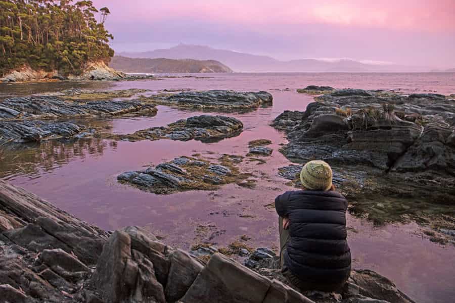
Beyond that scrub line, we step into a primeval and punishing place. In this damp rainforest, slippery tree roots and limbs grope over the trail, which itself is slippery, muddy and steep. We climb under trees, over trees and through trees. We slide through mud, down rock slopes and into each other. I’m the literal dead man walking as we shuffle into Deadmans Bay, where we wash off mud and blood in a calm cove below camp, while several habituated quolls watch us go about our business.
The mountains are now behind us, and most of the beaches are still ahead. From Deadmans Bay a string of beaches roll out east, and for two days the South Coast Track is truly the south coast track.
Behind Prion Beach there’s brief relief from the walking, with rowboats tied up to the shores of New River Lagoon for hikers to cross the whiskey-coloured waters beneath one of Tasmania’s most prominent mountains, Precipitous Bluff.
Each beach now is a macabre artwork of washed-up bluebottle jellyfish – a sight that promptly brings an end to our ocean swims – and as we near camp behind Osmiridium Beach, the run of hot days has conjures up the blackest of storms.
Lightning flashes behind us, and we sprint for camp, but the clouds bring no rain, just stunning sparks of dry lightning. Within two hours we’re sitting on Osmiridium Beach enjoying the calmest and most colourful of sunsets. It’s three days later, when we finish the walk, that we learn the storm has set much of southern Tasmania ablaze. Ignorance is indeed bliss.
Our shortest walking day comes out of Osmiridium Beach – a freshener ahead of the second of the big climbing days across the South Cape Range. We stroll through the sandy beauty of Surprise Bay and over a headland to Granite Beach, where the track scales the cliffs to reach an elevated campsite.
Immediately below the camp, a stream pours off the cliffs, and beside this waterfall we set up lunch, watching for hours as the Southern Ocean relentlessly hurls itself against the coast. It’s like a seaside holiday in the midst of a big bushwalk, but it’s nothing compared to South Cape Rivulet at the end of the next day’s walk across the South Cape Range.
This final range is only half as high as the Ironbounds, but has its own notoriety. The crossing is infamously muddy – deep pits of typically Tasmanian slop – but in the middle of a dry summer, most of the ground has hardened. The gaiters we carry are nothing more than ballast.
With the way across the range easier than expected, we arrive at South Cape Rivulet by mid-afternoon. The sun is blazing, the sand is white, and the southern tip of Tasmania –South East Cape – stretches out across the sea to the east.
The mood in camp is festive – it’s almost everybody’s final night on the track – and the rivulet inviting. We swim and soak through the afternoon. It feels as though we’re cleaning and grooming ourselves for the pending return to civilisation. The kids bury themselves up to their necks in the sand, and by evening the rivulet lies as still as a puddle.
The final morning brings also a final and beautiful stretch of coastal walking. Within a couple of hours we’re turning off the coast and heading overland towards the finish at Cockle Creek, but not before one final treat.
At the very moment that we’re about to climb off the beach, I glance behind us, where waves curl ashore like great weights rolling to a stop. Inside the waves, I see shadows, and then suddenly the shadows are leaping. A pod of dolphins surfs towards the beach, returns to the waves and surfs in again. Under, over, under, over. It’s a knitting pattern in nature again, but one that’s infinitely more graceful than our own memorable day across the Ironbound Range.

