Gallery: Top Australian bushwalks
14 April 2010

From mountain traverses to sand islands and outback tracks, these are the best long Aussie bushwalks.
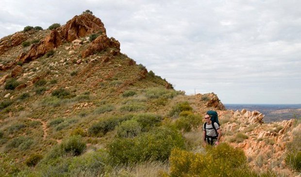
LARAPINTA TRAIL
Northern Territory
Running along the western end of the MacDonnell Ranges in the heart of the Red Centre, the Larapinta Trail is one of Australia’s most popular long distance tracks. Glenn Tempest raved about his trip, “It’s the quintessential Australian desert walk; you can’t get anything like it anywhere else.” He moved on to describe the brilliant red rocks, gorges and waterholes, clear air, beautiful temperate days, and crisp, insect-free nights, only some of the reasons so many people rate this walk.
It can be walked in either direction, but was originally envisaged as an east-to-west trek beginning at the Alice Springs Telegraph Station. This is generally considered the more scenic option, with the spectacular views from Mt Sonder, the highest point on the trip, saved as a fitting finale. The well-marked track follows high rocky ridges, meanders along creek beds at the base of the range and passes through the many gorges that dissect the landscape, taking in well-known NT landmarks such as Simpsons Gap, Standley Chasm, Ellery Creek, Serpentine and Ormiston gorges. Easy access allows the track to be broken up into one or two-day sections, while facilities such as water tanks and food-drop lockers are provided for the ‘223ers’ (the nutters who are doing the whole thing). Popular shorter options are the six-day walk from Standley Chasm to Ellery Creek, taking in much of the spectacular (and difficult!) country of the trail’s middle section, and the week-long trek from Ellery Creek to the trail’s end at Mt Sonder.
The remote, arid location and mind-blowing scenery allow a real feeling of isolation. But there’s also the atmosphere of the place, the submersion into the Dreamtime depths of an ancient land. As Quentin Chester says, “It’s not just the vibrant colour and graphic spectacle of the ranges that are laid bare. The walking also draws you into the soulful power of this landscape and its animating force in the lives of the Arrernte people.”
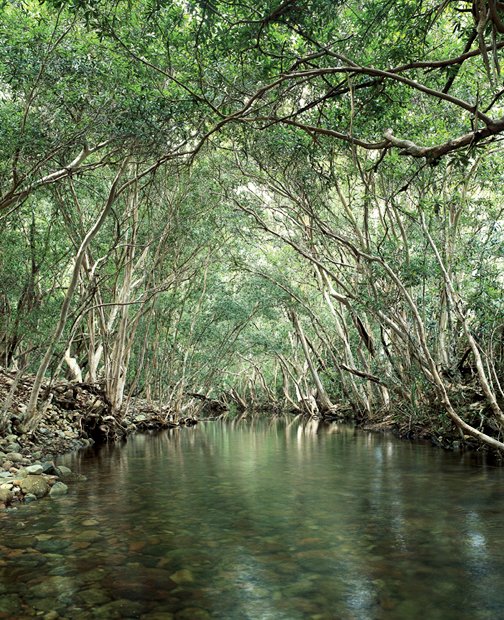
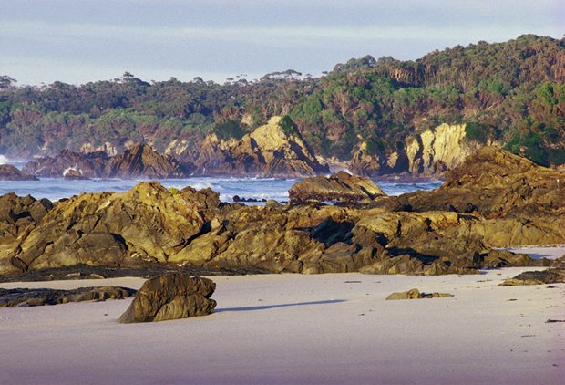
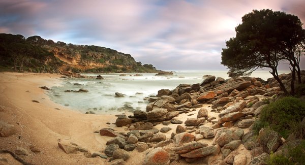
THORSBORNE TRAIL
North Queensland
Accessible only by boat, Australia’s largest island national park is a haven of wilderness; sheltering animals, marine life and vegetation that are now scarce elsewhere. Thanks to the island’s mountainous backbone, tropical beaches, rocky headlands and good track, the island’s east coast also offers a natural paradise to walkers. Spectacular jagged peaks, often shrouded by cloud, rise steeply from the idyllic bays and white beaches, their slopes hiding waterfalls and lunchtime waterholes. However, there’s more to the trail’s appeal than tropical beaches and scenery as John and Lyn Daly have described; the walk leads through an incredible array of vegetation, from rainforest, open woodland, palm and paperbark wetlands, to some of the most diverse mangrove forests in Australia.
The walk can be completed in either direction, with both ends serviced by public boat. The northern trackhead of Ramsay Bay is accessed from Cardwell, 184 km south of Cairns, with the boat to the southern end at George Point leaving from tiny Lucinda. The track is generally well marked and easy to follow, passing seven designated campsites, most close to the beach (and with toilets). Although four days gives ample time, a fifth day on this heavenly island is never a bad idea. Permits are required, with bookings required up to a year in advance, so be sure to apply early. Tropical considerations such as insects and native rats along with more serious ones such as crocodiles and box jellyfish, remind you that, yes, you are in Australia!
The highlights are many, from the swimming and scenery at Zoe Falls to the chance to see dugongs, dolphins and sea turtles and witness the armies of tiny blue soldier crabs as they sweep up the sand.
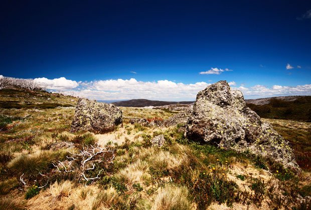
AUSTRALIAN ALPS WALKING TRACK
The ACT, NSW and Victoria
“The best of the really long-distance tracks in the country. It’s very varied, ranging from the high country of Kosciuszko and the Bogong High Plains to the dissected river valleys of the lower sections,” says guidebook guru John Chapman. This mammoth trek through the heart of the Australian Alps takes between seven and nine weeks to complete in either direction, from Walhalla (Victoria) to Tharwa (ACT). There are many variations, with the most common route detouring from the official track to take in the peaks of the NSW Main Range.
The term ‘track’ is actually a misnomer as the AAWT is a wilderness-style adventure with little in the way of facilities, the walking varying from 4WD trails to unmarked bush-bashes. It’s not for the inexperienced, with good navigation skills required, along with the planning of five or six food drops, as well as weather and water considerations. Compensation for the difficulty of even beginning the walk is found in some of the country’s most spectacular scenery, from the Bogong High Plains, Mt Howitt region and Barry Mountains, to Mt Jagungal and the peaks and lakes around Mt Kosciuszko. Piecing together the alpine area into a complete wilderness jigsaw has to be one of the best ways to understand this region, while also allowing time to understand John Siseman’s philosophy; “‘I view long-distance walking as a way of life rather than a means to reach a specific destination, best summed up in the creed that it is better to travel than to arrive. As one day fades into the next, I often wish they could go on forever, the only destination being a nomadic and carefree life.”
For those without a spare couple of months, some walks taking in AAWT highlights include the four-day circuit from Mt Howitt along the Crosscut Saw to Mt Speculation and the Razor Viking, a week-long circuit of the Bogong High Plains, or one of the many variations possible from Tharwa to Thredbo, passing close to most of Kosciuszko National Park’s 2000 m peaks.
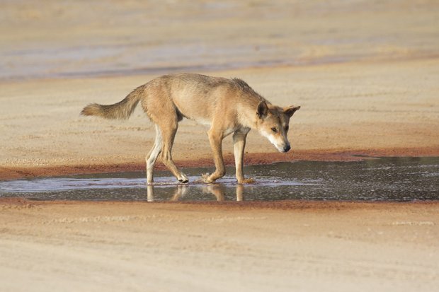
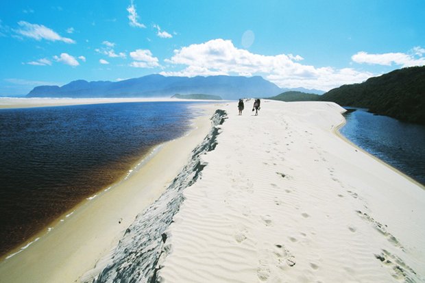
FRASER ISLAND GREAT WALK
Queensland
The most popular recreation on Fraser, the world’s largest sand island is still four-wheel-driving, but that has been slowly changing since this walk opened in 2004. As Quentin Chester says, “Forget the 4WD – the best way to enter the spirit of the island is to take this leisurely ramble through its forests and creeks. Although you visit popular haunts along the way, there are also long stretches of remote solitude to savour, plus some serene lakeside campsites.”
Following tracks and old roads through the island’s interior, the logging history of the area is evident in the abandoned tramlines and logging camps. Luckily the island still has substantial stands of rainforests, with one of the campsites located in the aptly named Valley of the Giants, resting beneath massive satinays and a thousand-year-old tallow-wood. There are also sandy beaches, sand blows and unpolluted freshwater lakes to explore, ranging from the sparkling clear blue of the renowned Lake McKenzie to the huge, tannin-stained Lake Boomanjin and deep Lake Wabby. Animal life includes abundant goannas and a very pure strain of dingoes – these have become a potential danger, especially to children, and precautions such as dingo-proof food storage at campsites are necessary.
Both navigation and the walking are generally easy, with road access to many points allowing the completion of shorter loops. Facilities are good, with water, toilets, dingo-proofing, and, in one case a hot shower, available at campsites. The island can be reached year-round, with boat transport running from Rainbow Beach and Hervey Bay (three-and-a-half hours from Brisbane). The walk can be completed in either direction, with the trackheads at Dilli Village and Happy Valley reachable by vehicle or taxi. Not exactly an isolated adventure, but is certainly a real Aussie experience complete with dingoes, beaches and a whole lot of sand.
WILDERNESS COAST WALK
South coast of Victoria and NSW
Truth be told, the actual wilderness coast stretches all the way from Cape Conran in southeastern Victoria to NSW’s Ben Boyd National Park, near Eden. However, this shorter walk from Mallacoota to Wonboyn takes in the most remote section and the highlights of this windswept wonderland. The Dalys describe their vote thus; “Following the Victorian coastline east past freshwater lakes to the border at Cape Howe, the terrain changes abruptly from massive white sand dunes behind wide, sweeping beaches to huge rocky cliffs’” Throw in the remains of a boat or two and the opportunity for plenty of refreshing swims, and you have a walk that joins the thong and stubby holder in the illustrious category of Aussie classics.
Contained within the Nadgee–Howe Wilderness Area, the largest remaining natural area on the southeast coast and a place of dunes, ocean views and shipwrecks, the walk follows beaches and tracks through coastal shrub and across moors. Campsites beside the ocean or freshwater lakes allow excellent bird watching, while views up and down this vast, undeveloped coast give a welcome sense of isolation.
The winds in these parts can be fierce, and walking from west to east may prevent a sand-blasting from the prevailing southwesterly. Water can also be difficult to find and rather murky; check with the local rangers and take a filter. Reaching the walk’s start at the not-so-imaginatively named Big Beach usually requires a boat trip from Mallacoota.
This trip can be shortened to end at Merrica River, or extended by a few days to include the popular Light to Light Walk in Ben Boyd National Park, thereby following the entire eastern section of the wilderness coast. An entirely Victorian walk from Point Hicks to Mallacoota is another five to seven day option. And if you’re really keen, you can always piece it all together into an 18-day trip.
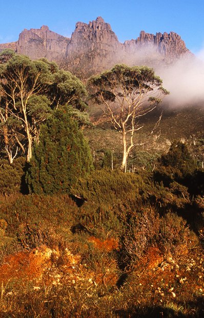
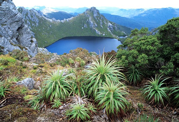
OVERLAND TRACK
Tasmania
Australia’s most famous walk is a drawcard for walkers from around the world. The scenery is spectacular and diverse, an otherworldly landscape of rocky peaks rearing from alpine plateaus and forested valleys hiding pristine waterfalls. The Overland Track itself is relatively straightforward, and can be completed by your average walker in five days. But it’s the side trips that make the walk; clambering up the craggy sides of Cradle Mountain or Mt Ossa (Tasmania’s highest peak), or winding through the forest into Pine Valley and the wild Acropolis. They lead you to waterfalls, to glorious dips in alpine lakes and breathtaking views across Tasmania, and will add a few days. The excellent track keeps walkers out of the mud while simultaneously protecting and showcasing the scenery and Tasmania’s unique vegetation, from buttongrass and pandani to the deciduous fagus and scratchy scoparia.
The Overland Track experience is a social one. After more than 70 years as a recognised track, it’s also not your classic walk in the wild. There are huts, toilets and tent platforms at most campsites, kilometres of constructed track and even the option of becoming a ‘soapie’ by doing a guided trip, complete with showers, meals and wine! The walk’s popularity makes most of this infrastructure (and other measures, such as a permit system and fees) necessary. And it seems to work; the landscape is remarkably untouched, while the walk’s popularity has made access and navigation easier. However, the Overland Track is not just a walk in the park; the weather is notoriously fickle, with snow, howling winds and bad visibility not uncommon, even in summer.
The track begins at Cradle Valley and ends at Cynthia Bay, both of which have good public transport links. There are many options for extending the walk, with John Siseman’s favourite being a 10 to 12 day trip from the Western Tiers into the Walls of Jerusalem, then via lakes Ball, Meston and Adelaide to join up with the Overland Track at Hartnett Falls, ending at Cradle Valley.
EASTERN ARTHUR RANGE
Tasmania
Federation Peak has been described as the mecca for Australia’s hard-core bushwalkers, with its dramatic rocky spire, remote location and difficult ascent adding to the allure. Reaching the summit used to require month-long scrub-bashing approaches, air-drops of supplies and other expeditionary preparations. Nowadays there are a number of different access options, with the most popular being the return trip into the Arthurs from Scotts Peak Dam via sections of the Port Davey and McKays Track. Increased traffic has reduced scrub and eased navigation, although it is all relative – nothing here is easy! Less than half of those who come to climb the peak reach the summit, with the atrocious weather and difficult final ascent preventing success. But people are drawn by the chance to lose themselves in one of Australia’s great wildernesses, testing themselves to reach the top with its view of jagged peaks, glacial lakes and wild river valleys as far as the eye can see.
As it’s a return walk, there aren’t any surprises in store on the way back, and the first and last days of walking are unexciting. The track is muddy, rough and steep, with pack-hauling necessary, and much of the walk is exposed to the full brunt of the famously awful weather – it’s not an area for the faint-hearted or inexperienced. Snow, horizontal rain and other hazardous conditions are common, and allowing 10 to 12 days will increase your chances. The final ascent to the summit requires 200 m of rockclimbing above a 600 m drop to Lake Geeves, a fall resulting in certain death. But it’s one of the country’s real bushwalking challenges, traversing a wild area of rugged peaks, small open moors and scattered lakes over which the iconic peak looms. How can you say no?
The route is serviced by public transport in summer, adding to its popularity. Another common route is a harder walk of similar length from Scotts Peak to Farmhouse Creek. The Eastern and Western Arthurs’ routes can also be combined into a grand tour taking 14 to 18 days for the walking alone.
WESTERN ARTHUR RANGE TRAVERSE
Tasmania
“The best mountain range in the country. A bit difficult for some, but the scenery is awesome and the walking at times spectacular and dangerous,” says John Chapman.
This classic skyline walk over jagged peaks traverses the most rugged mountain chain in the area, containing the largest number of peaks and lakes. Dramatic views of sparkling tarns and quartzite crags are found along its length if the weather cooperates; but this is the South West; on average only one in four days is clear. Driving rain, storms and mist are also an unforgettable part of the Western Arthur experience.
As with its eastern sister, foot traffic and the work of park staff have reduced both the scrub and the traverse’s difficulty, with track hardening, platform and toilet installation aiming to reduce the environmental impact brought about by the walk’s popularity. It’s still no picnic; ascending and descending steep gullies, scrambling over cliffs, roots and branches is slow going, with daily distances of 5 km or less common. A rope, the skills to use it and a head for heights are handy, as are bucketloads of experience and good navigation.
Beginning, as for the Eastern Arthurs walk, the full traverse leaves McKays Track near Alpha Moraine. Following the rocky ridge across a constellation of peaks such as Hesperus, Orion, Pegasus, Capricorn and Scorpio and camping beside the equally atmospheric lakes of Oberon, Haven and Promontory, the steep, sidling way ends at Lake Rosanne before joining up with the Eastern Arthur route again near Cracroft Crossing. Descending Kappa Moraine after completing the most spectacular section of walking to Mt Scorpio will reduce the walking time by two to three days. Walking west to east is recommended to keep the prevailing westerly wind at your back, while arcane sacrifices to the weather gods may also ease your passage.
CAPE TO CAPE TRACK
Southwest Western Australia
Perched at the very southwestern tip of the continent, the Leeuwin–Naturaliste National Park stretches between the lighthouses of its namesake capes, protecting a narrow strip of coastline near the wine region of Margaret River. The park is dominated by a 600 million-year-old ridge of granite, topped with sand dunes and bordered by limestone sea cliffs, giving diverse scenery, a rugged, rocky coastline and stunning beachscapes. The track is mostly along beaches and cliff tops, although there is an inland section or two, including one through the Boranup karri forest where the sound of the wind through the tall, swaying trees replaces the swoosh of the sea. As well as wine, the region is famous for its wildflowers, with the pimelea, fan-flower, cockies’ tongues, coral vines and numerous other species putting on a riotous display that attracts visitors every spring. Parrots, honeyeaters, wrens and birds of prey take advantage of the abundant food, while you may be lucky enough to have sunbaking sea lions battling dolphins and whales for your beachside attention.
The region is well-developed, with the many access roads allowing shorter sections of the walk to be completed. Although it’s not wilderness, the coastal strip is relatively natural, with scattered access points and camping grounds met but quickly left. Signs mark the track, which clambers over rocky coast and romps along old 4WD trails, sampling all the track conditions in between. Basic bush campsites with water tanks and toilets have been established (although water can be unreliable, especially in summer), with commercial camp grounds often a possibility if you fancy a local drop with your gourmet dinner.
Walking south to north will keep the predominant wind behind you, while buses to the closest towns of Augusta and Dunsborough will get you to within a taxi ride of the trackheads.
SOUTH COAST TRACK
Tasmania
Another Tasmanian entry, the South Coast Track is justifiably famous. Not only for the terrific scenery, remote beaches and the chance to spend a week tracing the edge of a huge wilderness, but for the opportunity to wallow in glorious, boot-eating, knee-deep mud. However, track work has made progress easier and, though there is still a fair amount of mud, apparently the bog-fest reputation is no longer deserved.
The track follows the spectacular (you guessed it!) southern coastline of Tasmania, sticking to the coast along the beaches and crossing long sections of open plain. It detours around impassable sections of coastline leading up the formidable Ironbound and South Cape Ranges, with the former giving the toughest day on the track, requiring a climb and descent of around 900 m. This vantage point, however, has a great reward, giving views over the peaks and bays of the track, and beyond if the weather allows. Kilometres of walking along wide beaches that are constantly buffeted by the wild ocean, watching coastal sunsets from camp, and crossing (with care and, on one occasion, rowboats) the deep, wide, tannin-stained waterways are other highlights.
Most people choose to fly into Melaleuca and walk from west to east, reasoning that days spent waiting for the weather to clear would be more enjoyable in hedonistic Hobart (it’s all relative!) than on an airstrip in the middle of nowhere fantasising about chocolate and showers. For those with time on their hands or a fear of flying, a four-day walk along the Port Davey Track will also get you to Melaleuca. It is recommended that you carry enough food for an extra day or two as bad weather (snow can occur on the Ironbound Range, even in summer) and swollen creeks can require patient waits. The only huts are at Melaleuca, and facilities are restricted to pit toilets. But what else would you expect while crossing the southern edge of the largest temperate wilderness area in the world?
Home Australian Geographic Adventure Adventure Gallery: Top Australian bushwalks

