
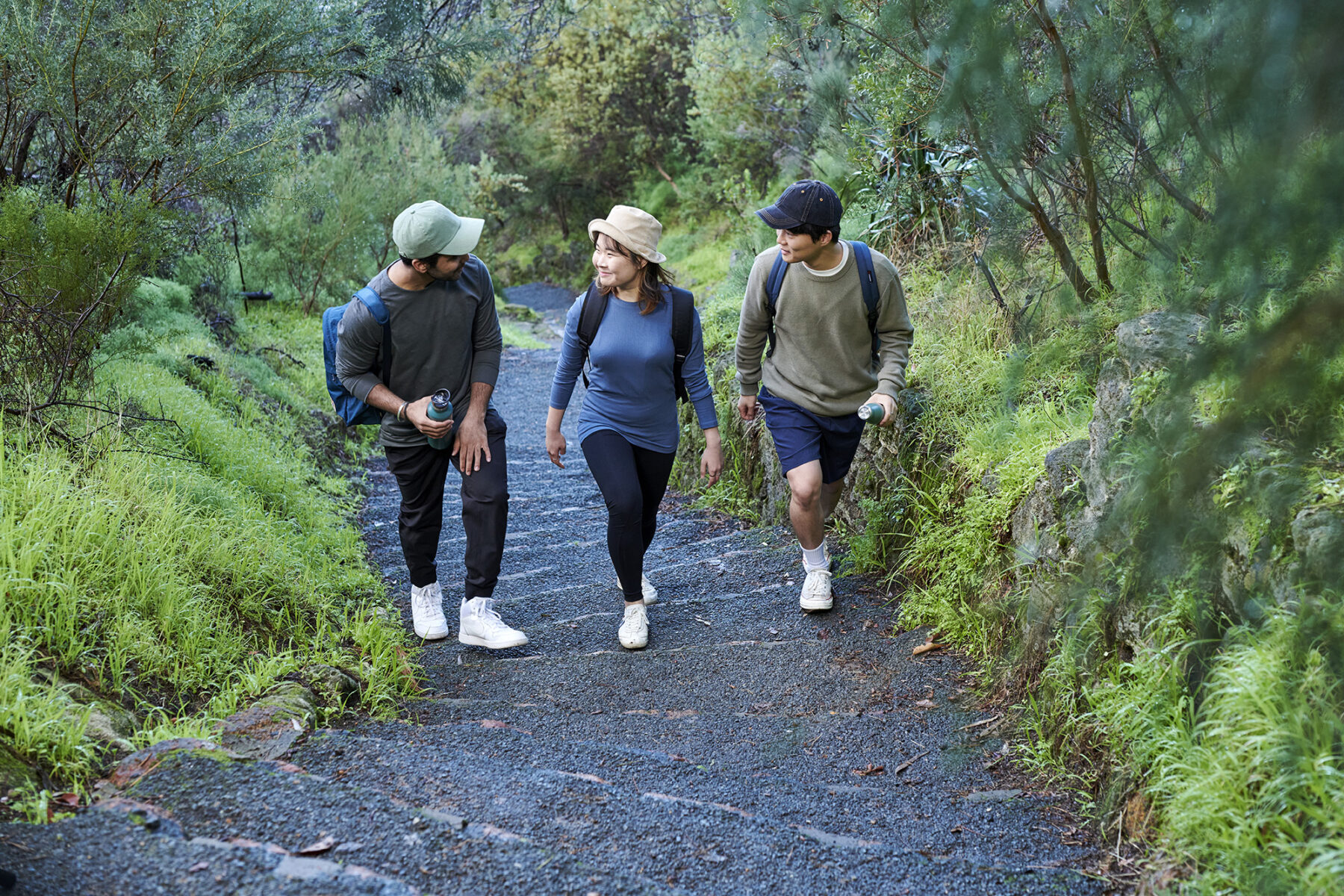
Walking is one of the most accessible outdoor activities and Australia is packed with enough tracks to explore on foot over many lifetimes, from two-hour strolls to week-long journeys through remote country. In this, the fifth instalment in our great Aussie walks series, we showcase five of the most worthy in Western Australia.
Bluff Knoll
Distance: 6km circuit Time: 3–4 hours Difficulty: Hard
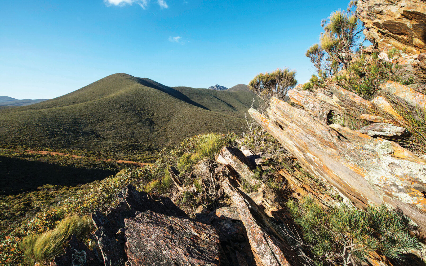
Bluff Knoll (1095m) is the crown jewel of the Stirling Range, the highest peak in southern WA, and the only place in the state to get snow with any frequency. Naturally there are outstanding 360 degree views from the summit on a clear day. But swirling winds at the top mean that cloud can close in quickly. In fact, the local Aboriginal people’s name for the range, Koi Kyenunu-ruff, means ‘mist rolling around the mountains’. The walk starts from the Bluff Knoll lookout and picnic area. After a kilometre there is some shade by an ephemeral waterfall. The trail now turns south across the mountainside before crossing a saddle and swinging north to follow the ridge to the summit. Here you can see the southern ocean beyond blue peaks and a patchwork of fields below. Many walkers like to stay for sunset but make sure you take a torch for the descent.
The Stirlings are the remnants of an ancient sea, consisting of many layers of sedimentary rock – mostly sandstone and silt-stone – deposited over a long period, beginning 1.8 billion years ago. As the stone weathers differently, the alternating hard and soft sedimentary layers give the Stirlings their characteristic jagged edges and steep cliffs. As you climb to Bluff Knoll exposed outcrops reveal these layers in the rock.
Like the neighbouring Porongurups, this park has incredible biodiversity. More than 1500 native flowering plant species have been identified, with more than 80 found nowhere else. The different soil types and elevations have resulted in a variety of vegetation communities, from wetlands to woodlands, thicket and mallee-heath. The taller peaks above 750m also house a unique ‘montane’ ecosystem. Flower-lovers should plan to walk from Aug–Nov.
Both the Stirling and Porongurup ranges are deep-seated in the culture of the local Noongar people, but they have different meanings to different groups, depending on their location and the view of the ranges from their traditional lands. To the Goreng of Gnowangerup, north of the range, the Stirlings are a place of great significance, only visited on important occasions. Bluff Knoll is also known as Bular Mial, or ‘many eyes’. The Goreng believe it is where their spirits go after death, and the eyes are their ancestors watching over them.
Piccaninny Gorge
Distance: 14km return Time: 3–4 hours Difficulty: Easy
One of Australia’s most remote and magnificent national parks, Purnululu National Park was listed as a World Heritage Site in 2003, yet many Australians had never heard of it. The distinctive sandstone beehive domes of the Bungle Bungle Range are found in the southern area of the park where the Piccaninny Creek bed winds through this surreal landscape of rippled rock. The Piccaninny Gorge Trail (30km return) is a long trail for experienced walkers – one of the best walks in the park is to start this trail, following the dry bed of the creek until the ‘elbow’ bend or whenever you’ve had enough and then return, for this provides spectacular perspectives on the domes the whole way. About 5km from the start there is a turnoff for Whipsnake Gorge, a small, shady gorge filled with rock figs and ferns, and this is also a good spot to aim for, have a rest, then turn back.
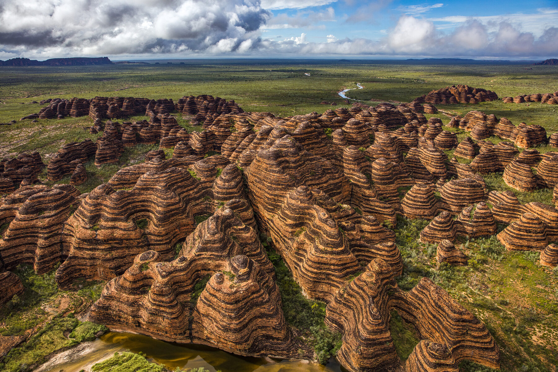
The 50km access road is a rough, high-clearance, 4WD-only track that keeps the number of ground visitors low but this park has an otherworldly beauty well worth the effort to get here – especially if you can stay a few nights. The pebbles in the dry creek bed can be a bit hard on your feet so make sure you wear sturdy shoes. Also take plenty of water, it can be very hot and there is no reliable drinking water. The park is only open in the dry season, April to November.
Kings Park Explorer
Distance: 7.7km circuit Time: 2 hours Difficulty: Easy
London has Hyde Park, New York has Central Park, Perth has Kings Park. At 4sq.km, this is the largest area of natural bushland to be found near the CBD of any Australian state capital. It is the city’s pride and joy and that is reflected by the number of Perth locals who use it for recreation – over 5 million people visit every year. This walk takes you through the Botanic Gardens, on the Federation Walkway (with a very impressive 222m-long glass and steel viewing bridge that rises to a height of 16m and allows visitors to walk through the tree tops) and through bushland that contains 291 different species of native plants.
Start at the visitor centre to pick up a map, then follow the path down to the large, silver arch which marks the entrance of the Botanic Garden, turning right at the entrance. Soon you’ll come to a stand of boab trees including Gija Jumulu, the giant boab, which was moved from its natural habitat in the Kimberley to Kings Park. Follow the path through the tuart trees (a remnant of the original vegetation) where you’ll see the Pioneer Women’s Memorial lake and statue to your right. Just before the viewing bridge is the Mt Eliza Lookout which gives views over the meeting of the Swan and Canning Rivers. At the end of the walkway follow the signs for Roe Gardens and the Place of Reflection where the path joins Forest Drive. After approximately 300m bear left into the Broadwalk, a long, narrow sweep of lawn reminiscent of a grand English country estate. You can climb the DNA tower to catch a glimpse of the Indian Ocean to the west, named for its resemblance to the double helix of a DNA molecule. At the end of the Broadwalk swing right to head towards the Saw Ave Picnic Area, then take the dual-use path through bushland, fullof wildflowers in spring, up to the Lotterywest Family Area. Follow the signs back to the visitor centre.
Walpole to Peaceful Bay
Distance: 63km one way Time: 3 days Difficulty: Medium
Anyone walking in Western Australia must attempt a section of the mighty Bibbulman Track, stretching 1000km from Kalamunda in the Perth Hills, to Albany on the south coast. Naturally the track offers landscapes for every taste and many ways to tackle it, from self-sufficient camping adventures to fully guided walks or relaxed day walks from a township base. The section from Walpole to Peaceful Bay encompasses some of the best scenery in WA – the massive red tingle trees of Walpole, tranquil Frankland River and magnificent coastal views from Conspicuous Cliff and Rame Head.
The first day starts with a walk through heathland above Walpole Inlet before climbing to Hilltop Lookout
with spectacular views of over a cloak of karri and marri forest to Walpole and Nornalup inlets and the southern ocean beyond. In the forest beyond lies the Giant Tingle Tree, the largest on the track. Hollowed out by fire, its giant buttresses could swallow a car. The red tingles (Eucalyptus jacksonii), found only in south-west WA, are wonderfully knobbly and broad trees that can grow to 75m tall and 24m round. Full of character, they seem just about to lean over and impart some sage advice. Frankland River campsite has a comfortable hut on the riverbank to rest before the second day of walking in tingle and karri forest on the way to the Valley of the Giants, where there is a magical walkway in the forest canopy. The third day is marked by the transition from forest to coastal heathlands and culminates in the high dunes and wild waves of the southern ocean at Conspicuous Beach. The final day’s route to the shallow, turquoise waters of Peaceful Bay traverses coastal scrub filled with wildflowers, rugged beaches and granite headlands.
Check with Walpole Visitor Information Centre for help with transfers. See bibbulmantrack.org.au for detailed maps and guides.
The Loop Trail
Distance: 8km circuit Time: 3–4 hours Difficulty: Medium
This rugged walk follows the course of the Murchison River deep in Kalbarri National Park where it loops back on itself. It’s well worth taking the time to explore this arid elemental landscape away from the crowds at the popular landmarks and new 100m-high skywalk at West Loop. Look out for reptiles such as the thorny devil or sand goanna and dainty wildflowers in spring.
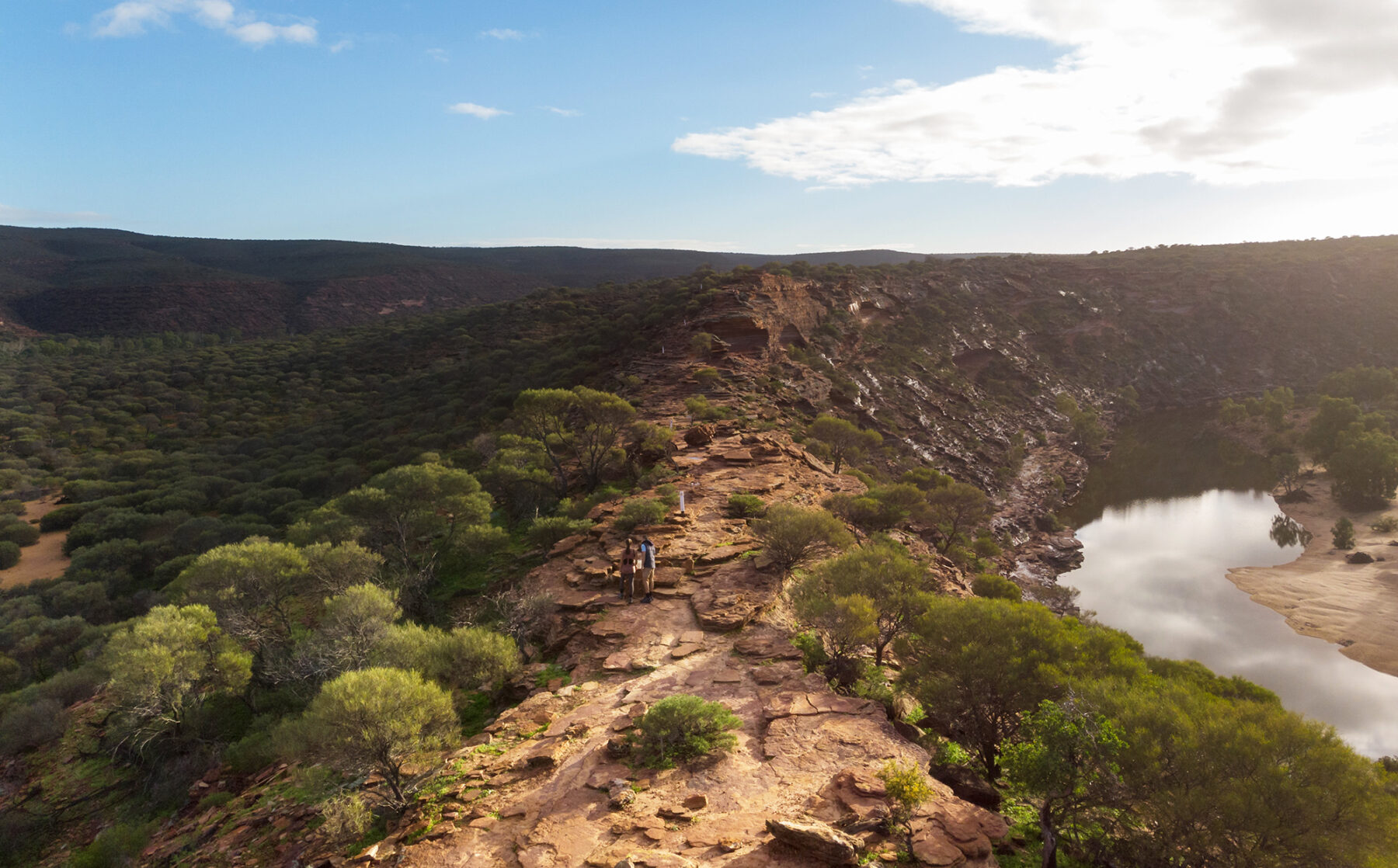
The park’s red-and-white banded gorges are made up of sedimentary rock called Tumblagooda Sandstone. These striking horizontal layers of sand were deposited 400 million years ago and have eroded into shapes such as Nature’s Window, a rock arch that frames a view of the riverbed below
and marks the start of this trail. The first third of the walk follows the cliff top before descending steeply to a beach at the bottom of the gorge. The next third is a bit more tricky, scrambling along riverside ledges, before the route opens up to traverse the sandy riverbank and gnarled gum trees for the final section. Be sure to stop for a swim or picnic before climbing out of the gorge back to Nature’s Window.
This walk can be extremely hot in summer and you must carry plenty of water with you. Many tourists have been evacuated from this park because they have been unprepared for the conditions. Try to walk in the cool of the early morning before the mercury rises – the softer light will reveal all the subtleties of the coloured stone. The river usually flows after rains in autumn or winter but may dry up to a series of pools in summer. It can also flood at any time if there has been heavy rain inland – if necessary, rangers will close the park.


