
Walking is one of the world’s most accessible outdoor activities. Australia is packed with brilliant foot-borne adventures, whether short sojourns to breathtaking viewpoints, or multi-day epics that truly take you into the wild. And no part of Australia conjures up “wild” like the NT and, in part six of our great Aussie walks series, we reveal five of our favourite, and truly wild, walks in the Northern Territory.
The Valley of the Winds
Distance: 7.4km circuit Time: 3 hours Difficulty: Medium
The domes of Kata Tjuṯa lie about 30km to the west of Uluru, visible across a low sand plain. Although lesser known than the great rock in the distance, they are easily as beautiful, if not more so. The Anangu name means ‘many heads’ and there is something curiously lifelike about the smooth, high domes huddled together. Between them, the cool, deep valleys have the mystery and silence of a cathedral. Unlike the more accessible snake legends of Uluru, the meaning of this place must remain mysterious. Its sacred stories are considered men’s business and under Tjukurpa (law) cannot be revealed to the uninitiated. Many people don’t find the time to visit Kata Tjuṯa but those that do often find it surprisingly moving and impressive.
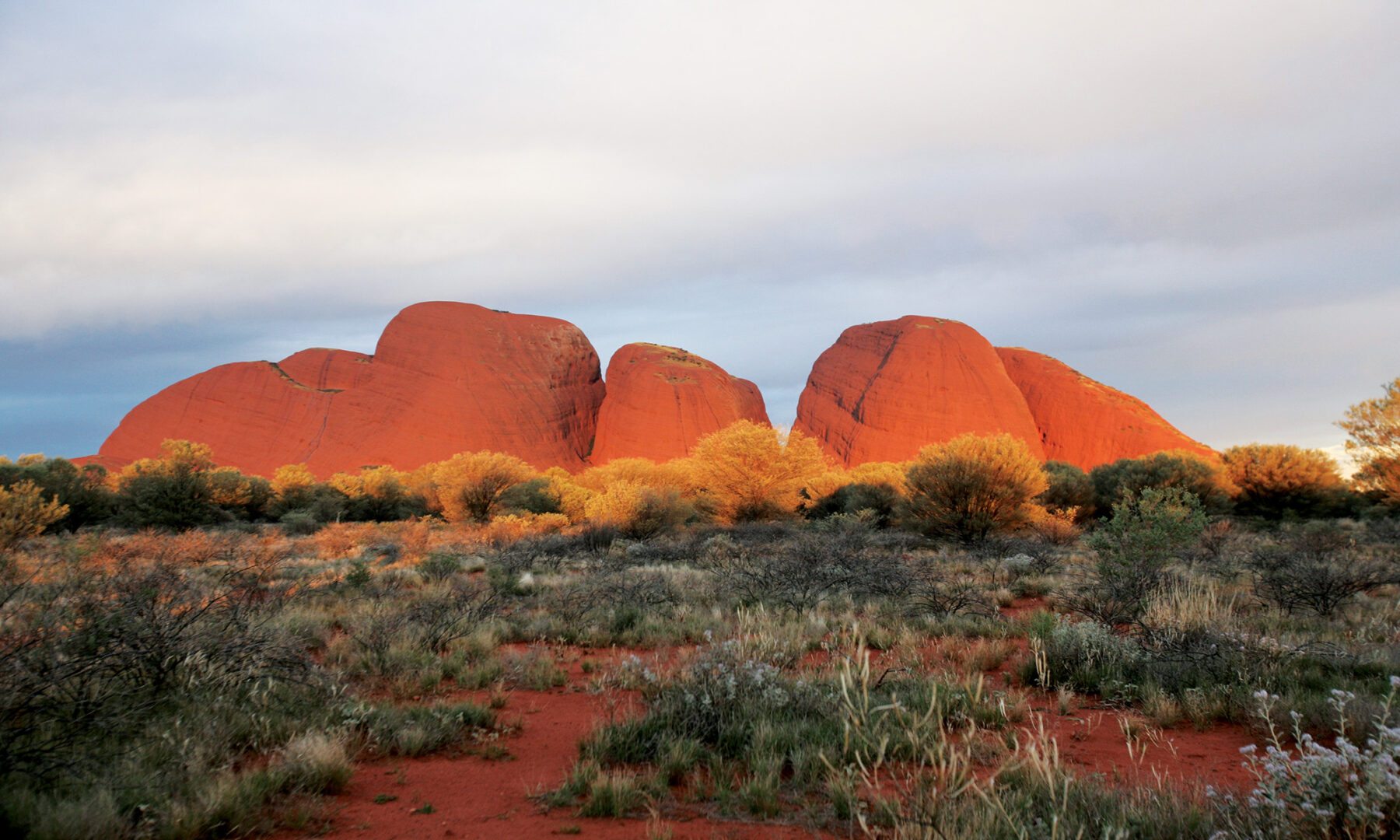
The Valley of the Winds walk takes you deep into the heart of the domes. From the carpark the path heads east to Karu Lookout, where there is a striking view into the valley. From here the trail switches back downhill and then continues east, passing close to a rock wall where you can inspect Kata Tjuta’s conglomerate more closely: the explorer Ernest Giles described it as rocks “mixed as plums in a pudding”. Reaching the valley floor, a trail junction marks the start of a loop where you turn right to climb towards Karingana Lookout. From here you pick your way carefully down the steep, rocky slope to cross a creek bed and emerge in open scrubland, before swinging north-west to a ridge where there are sweeping views back down the valley. Passing a water tank, the route heads south to follow the creek bed, lined with river red gums and bloodwoods, to complete the loop. From here you retrace your steps for half an hour to the carpark via Karu Lookout.
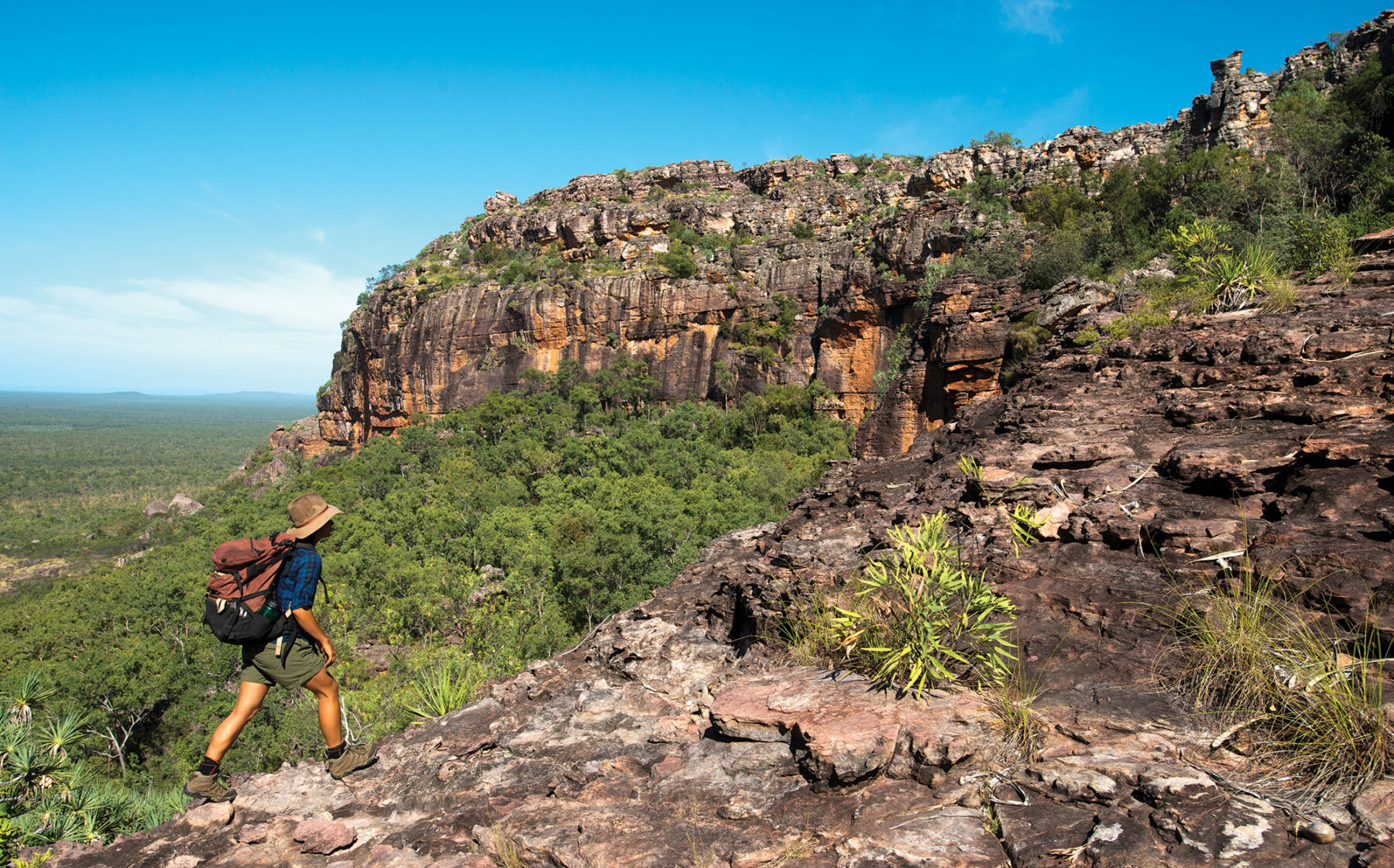
Kings Canyon Rim
Distance: 7km circuit Time: 3–4 hours Difficulty: Medium
Named for a western quoll linked to a dreaming route of the local Luritja people, Kuninga/Kings Canyon is part of the George Gill Range, enclosed by Watarrka National Park. The 6km walk around the rim of the canyon is simply one of Australia’s very best half day walks. The walk begins with a steep climb to the top of the canyon, where a lookout reveals the sheer, 100m-high canyon wall, patterned by horizontal bedding planes, vertical water stains and myriad tiny hieroglyphic-like fissures. Later, you’ll meander through the Lost City where a grid of 350-million-year-old hairline cracks in the rock surface have been weathered down into hundreds of beehive domes. Many rare plants and 100 reptile species shelter in the crevices. There is little shade to be found on this walk, except in the Garden of Eden, a lush permanent waterhole lined with ferns, cycads and palm trees. There is also a shady short walk up Kings Creek with views of the canyon walls from below.
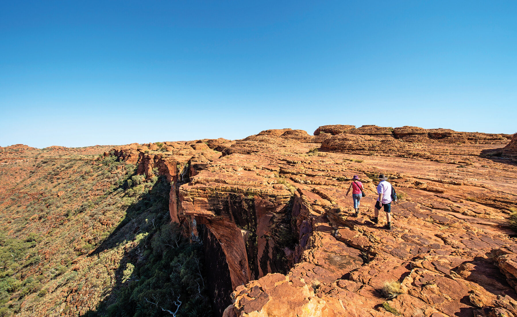
This walk is deservedly popular, so you won’t be alone, but this is a big landscape. It’s best to start early so you can avoid the heat, linger in the many scenic spots, and soak up the atmosphere. In fact, when the temperature is forecast to be 36°C or above, walkers must undertake the Rim Walk before 9am. Although this is a shortish walk, it’s strenuous in the heat so take plenty of water.
Ormiston Pound
Distance: 9km circuit Time: 3–4 hours Difficulty: Medium
The West MacDonnell ranges were once the height of the Himalayas. Now sanded down by 300 million years of wind and water, these long ridges, corrugated like a tin roof, contain some of the Red Centre’s most bewitching scenery. Permanent waterholes, abundant wildlife and relict tropical plants flourish in the gaps, gorges and chasms of the Tjoritja/West MacDonnell National Park. One of the most enticing gorges is Ormiston, which marks the entrance to the expansive Ormiston Pound, an amphitheatre of mountains.
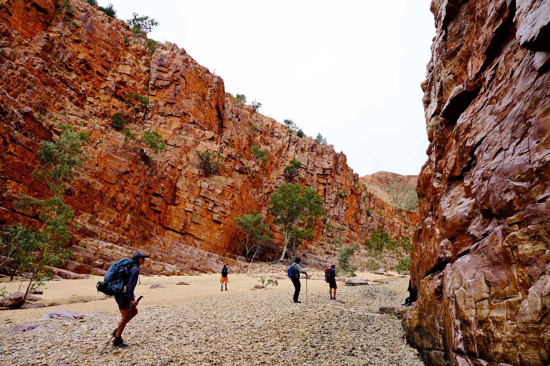
Starting from the visitor centre, the walk heads anticlockwise before crossing the bed of Ormiston Creek, lined with venerable river red gums. The path undulates across gullies and slopes, with intermittent views of Mt Sonder (1380m), amid corkwoods, bloodwoods, red-flowered grevillea and spinifex. After 45 minutes there are wonderful views of the Pound as well as Mt Sonder, Mt Zeil (1531m) and Mt Giles (1389m), the high point of the Chewings Range. Descending east from the lookout saddle into the Pound, the track swings north-west, and descends gradually to reach the sandy bed of Ormiston Creek, where you can either follow the creek downstream to some waterholes and shady gums or take a shortcut to rejoin the creek. Ascending the left bank where the waymarked track crosses the creek a second time, the path approaches the narrow entrance to Ormiston Gorge. There is a bit of rock-hopping in the gorge where the walls tower up to 250m high with gravity-defying ghost gums sprouting at unlikely angles from narrow shelves. At the track junction with the Ghost Gum Walk you can choose that longer, 1-hour route back to the visitor centre but you’ll forgo some of the finest gorge scenery. Consider camping at the gorge so you can spend more time here.
Jarnem Loop
Distance: 7km circuit Time: 2–3 hours Difficulty: Medium
In the far north-west of the Northern Territory, the rugged jewel that is Keep River National Park sparkles with dramatic landscapes, intriguing wildlife and spectacular rock art. Just 700sq.km, this small and remote park lies a mere 3km east of the border with Western Australia and harbours beehive-shaped domes of striped sandstone and silica that are remarkably like WA’s Bungle Bungle range.
The Miriwoong and Gajirrabeng people have lived in this area for thousands of years – painting haunting images of ancestral beings and animal totems in the park’s caverns and rock shelters, feasting on freshwater mussels and building stone hunting traps.
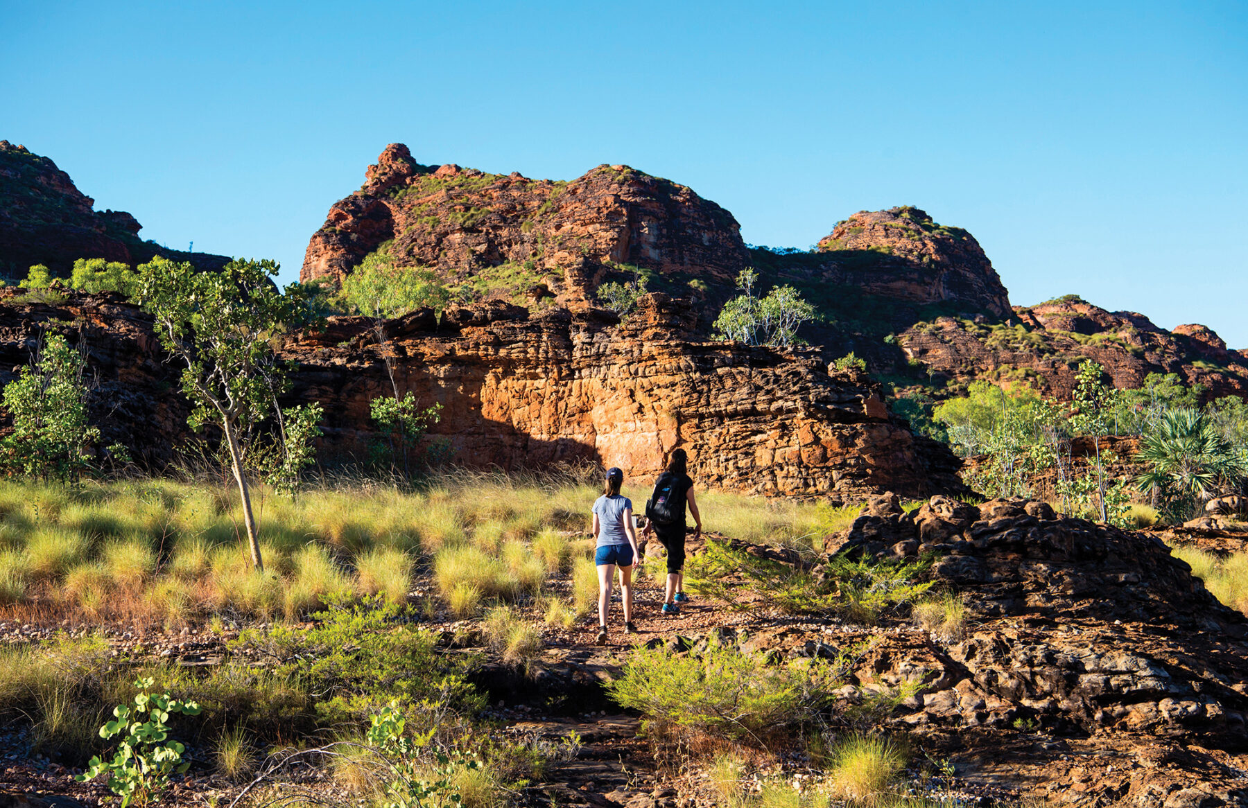
This walk starts from Jarnem campsite, along a 2WD gravel road about 30km from the park entrance on the Kununurra to Katherine highway. Heading to the lookout first, the trail passes through open savannah and gradually climbs between craggy hills covered with clumps of spinifex. From the lookout, the whole expanse of the park can be seen, including the Bungle-like Kelly’s Knob formations. Heading down onto the plains, the paths winds close to the beehive domes amid boabs, bloodwood trees and cabbage-tree palms. Rock art is found in caverns on the way to beautiful Nigli Gap, a sheer-sided canyon traditionally used by the Miriwoong as dry passage when the plains were flooded. From here the trail returns to the campground. This walk is best done early in the morning or late in the afternoon – both in order to stay cool and for the rich colours of the sandstone revealed in low light.
On the way in or out, bird lovers should stop at Cockatoo Lagoon – a semi-permanent waterhole near the entrance – to spot some of the park’s 190 bird species, including herons, brolgas, jabiru, green pygmy-geese, wrens and finches. Note that saltwater crocodiles are found throughout this park and swimming is prohibited.
Barrk Sandstone Walk
Distance: 12km circuit Time: 5–6 hours Difficulty: Medium
Established in three stages from 1979 to 1991, and World Heritage listed in 1992, Kakadu is Australia’s largest terrestrial national park, covering an area almost one-third the size of Tasmania (or the size of the nation of Israel). About one-third of Australia’s bird species have been recorded here, and it’s home to one-quarter of the country’s freshwater fishes. An estimated 15,000 rock-art sites, dating back as far as 20,000 years, are scattered across the park.
The stunning Barrk walk goes over and around Burrungkuy (Nourlangie Rock), a plateau that offers a glimpse into Kakadu’s grander stone country. Fractured sandstone rises in stacks and pinnacles and weaving through the small canyons in between is like wandering into a ruined Cambodian temple. Burrungkuy is also the canvas for two of Kakadu’s three major public rock-art sites, but like so much of the park, it has ancient art hidden everywhere. As this track descends the rock’s northern slopes and round its base, art peeps down from outcrops and decorates rock overhangs.
One of the longest and driest of Kakadu’s day walks, the Barrk track begins along the base of Burrungkuy, ascending though gullies to the sandstone plateau. The climb is steep at times, but feels hardest atop the dry plateau, where you’re exposed to the heat. Descending a gully to woodland at the base, there is a short side track to Nanguluwur art site where paintings depict spirits, animals, and a sailing ship. The rest of the route follows more open country with excellent views of the western cliffs of Burrungkuy.
Park authorities recommend that on a dry track such as Barrk, walkers carry at least a litre of water for every hour. The walk is open year-round – most people walk in the dry season (May–Sep) but some walkers claim the wet season is the most spectacular time to walk.


