Walking is one of the world’s most accessible outdoor activities. Australia is packed with some brilliant foot-borne adventures, whether short sojourns to breathtaking viewpoints, or multi-day epics that transport you deep into remote and beautiful parts of the country. In this third part of our great Aussie walks series, we reveal five of our favourites in spectacular South Australia.
Waitpinga to Kings Beach
Distance: 11.5km one way Time: 4–6 hours Difficulty: Medium
The Heysen Trail, named for German-born painter Hans Heysen, is a 1200km route that takes walkers from the coast to the outback along South Australia’s ancient mountain backbone. It starts (or ends) on the wild southern flank of the Fleurieu Peninsula, a coast of ravines, isolated beaches and ink-black cliffs plunging into the ocean swell. This section, just south of Victor Harbor, from Waitpinga to Kings Beach is one of the highlights of the whole trail. Starting at Waitpinga campground in Newland Head Conservation Park, the trail follows a fire trail to reach the coastline. The track then scrambles along the edge of the Waitpinga cliffs, where sheer, 100m-high walls are stacked in layers against the shoreline like colossal dinner plates in a rack. The cliffs end at King Head and its crescent beach. It’s an atmospheric walk, taking in the vastness of the ocean beyond. This precious sliver of coast is a valuable corridor for wildlife, including threatened birds of prey, such as peregrine falcons and white-bellied sea-eagles, so remember to look up as well as down.
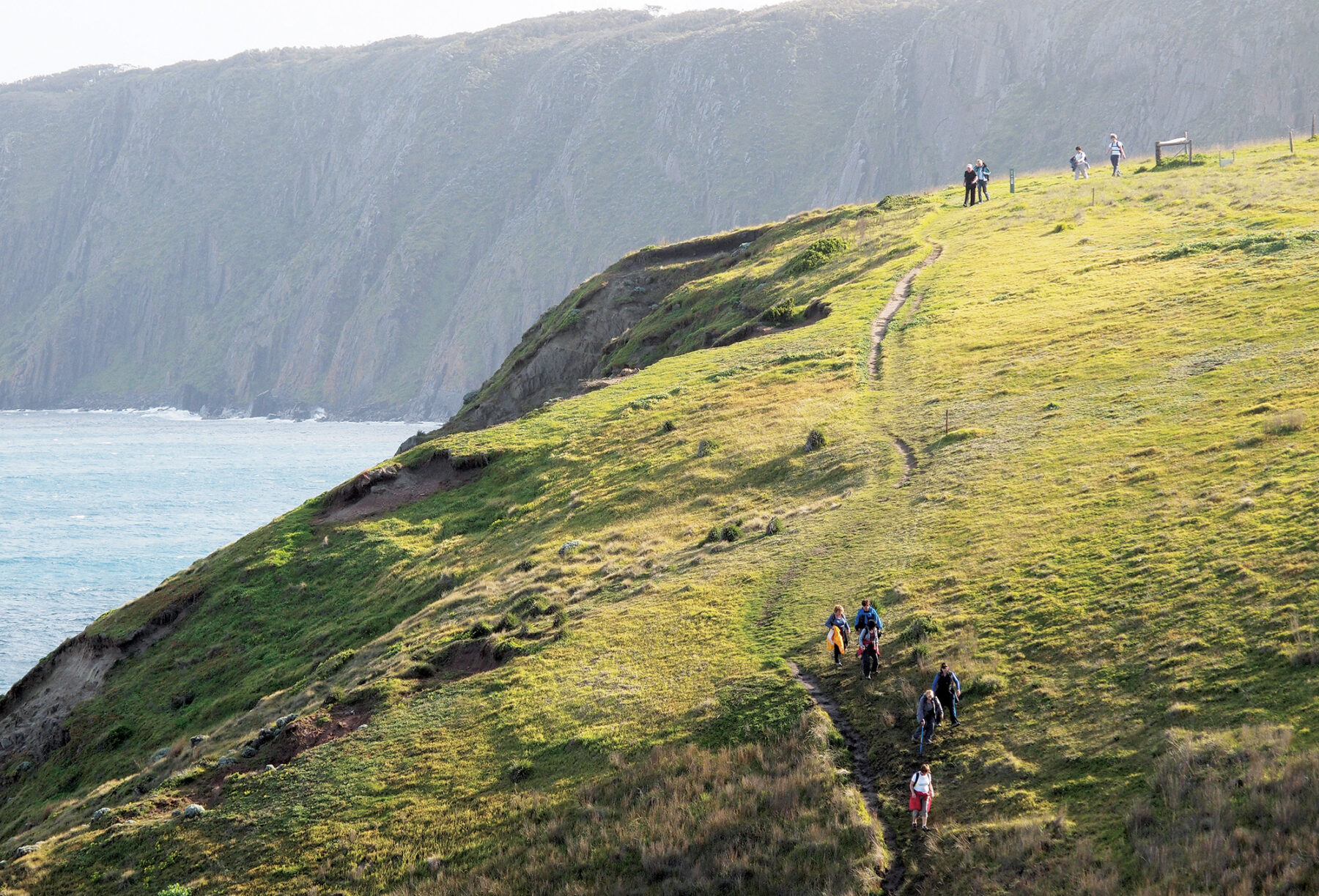
Just beyond Kings Beach stands Rosetta Head – known to many as the Bluff. From this vantage point the view back along the coast to the beach and the distant cliffs of Waitpinga is magnificent. On a bright August morning in 1925, Heysen sat on the saddle below the Bluff sketching the view. As it happens he wasn’t celebrating but grieving; only days earlier his beloved third daughter, Lillian, had died of meningitis, just shy of her 16th birthday. Yet somehow from his deep love of nature he found the strength to keep working and in the months ahead he completed a major oil painting of the scene. The South Coast is a beautiful, uplifting picture of crisp winter light with green hills and lines of surf breaking on the rocky shore.
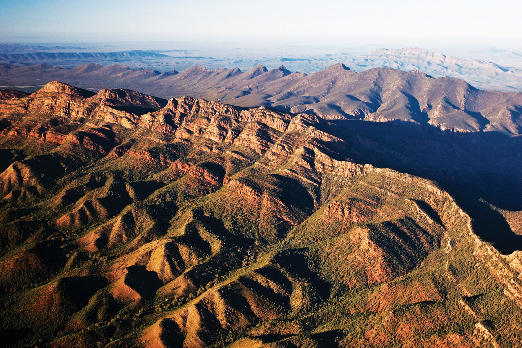
Bunyeroo & Wilcolo Creek
Distance: 9.2km circuit Time: 4 hours Difficulty: Easy
About 20km north of Wilpena Pound in the Flinders Ranges, this circuit walk in the gentle, rolling country of Bunyeroo Valley follows the paths of two creeks through the ABC Range, with a short climb to a wonderful lookout over the ancient, sinuous ridges of the Flinders Ranges. From the Bunyeroo carpark, the trail heads south along Wilcolo Creek, passing through the purple-tinged shales and open cypress pine woodland of the Bunyeroo Formation. Next swinging east, the route joins up with the Heysen Trail and crosses Wilcolo Creek to enter a narrow gorge through the ABC Range. There are enormous river red gums here and huge blocks of quartzite made of ancient, sandy riverbeds.

Beyond the gorge the route winds through more cypress pine woodland to the lookout. From here you can take in the sweep of the ABC and Heysen ranges and even see St Mary Peak in Wilpena Pound, 7km to the south. The track now swings north over Brachina Formation siltstones and sandstones, scattered with silver wattle and corkbark, to reach Bunyeroo Creek with its beautiful river red gums. The trail continues along the creek’s route west through the ABC Range.
Anyone with an interest in geology might also like to do the Bunyeroo Gorge walk from the same carpark. It’s an easy and fascinating stroll along the creek bed (7.5km return), through the Heysen Range, that reveals 50 million years of geological formations from the Precambrian and Cambrian periods.
Riesling Trail
Distance: 35km one way Time: 1–2 days Difficulty: Easy
The Clare Valley is a beguiling wine region, high in the northern Mount Lofty Ranges about 100km north of Adelaide. One of Australia’s oldest wine-producing regions, the Clare has many lovely 19th-century stone buildings and more than 50 wineries scattered along its rolling hills, including historic vineyards such as Sevenhill, established by Jesuits in 1851 for sacramental wine. This friendly region is occupied by small growers and winemakers rather than the big brands and is best known for riesling, shiraz and cabernet sauvignon.
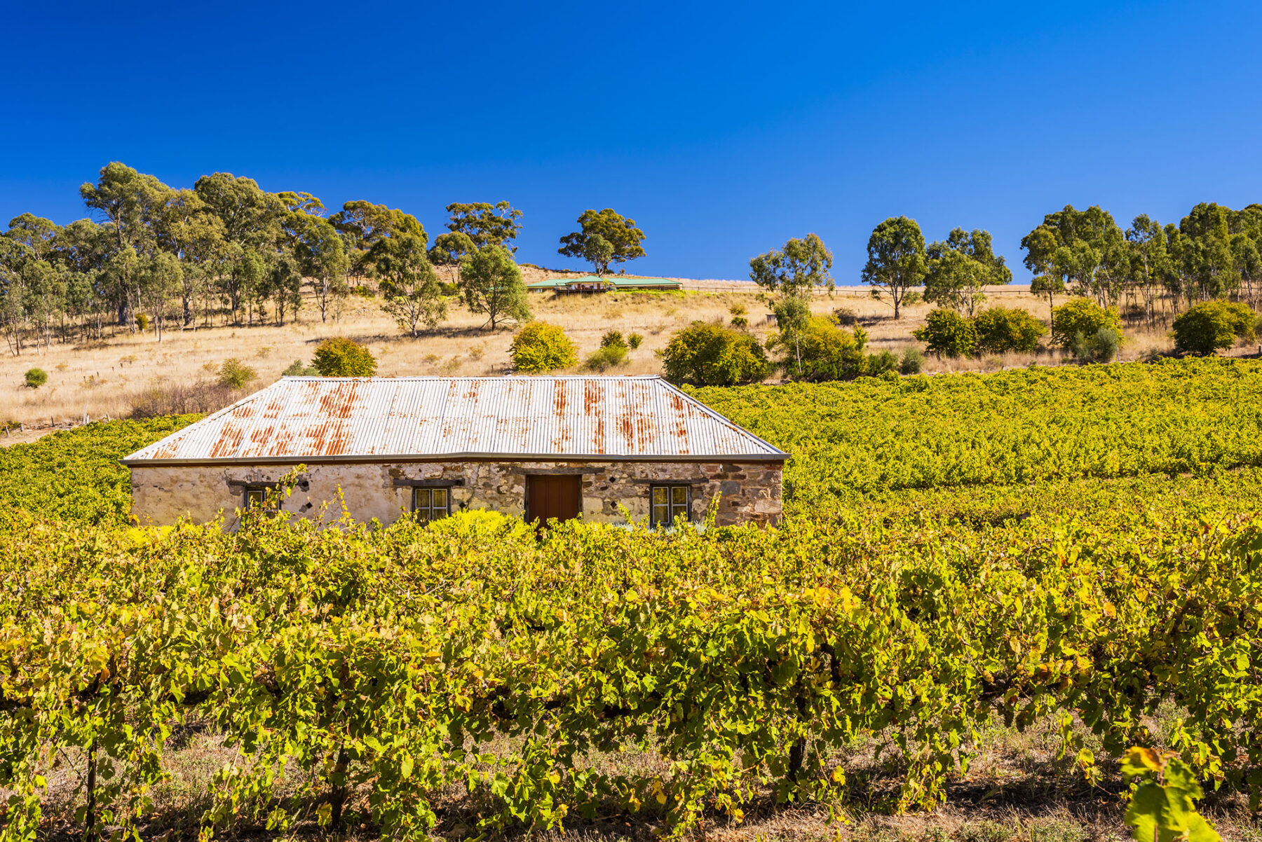
The flattish, gravel Riesling Trail was created for walkers and cyclists along the Auburn to Barinia section of the original Riverton to Spalding railway line. The trail passes through vineyards, farmland and woodland as well as the villages of Leasingham, Watervale, Penwortham, Sevenhill and the region’s commercial centre, Clare. It’s an easy walk designed for relaxed ambling and lots of stops to sample the region’s superb food and wine and talk to producers.
St Mary Peak
Distance: 21.5km circuit Time: 9 hours Difficulty: Hard
If Australia had its own seven wonders of the natural world, Wilpena Pound would surely be near the top of the list. It would vie with such luminaries as Kata Tjuta, the Twelve Apostles and of course Uluru, which, astonishingly, would fit within Wilpena’s walls six times over. But it’s surprising how many Australians have never heard of, let alone visited, this geological spectacle in South Australia’s Flinders Ranges National Park. Geologists describe the feature as a remnant elevated synclinal basin, and it was once enclosed by far higher mountains. Its steep walls and shallow inner bowl are made of thick layers of super-hard quartzite that have been squeezed along both east-west and north-south axes, forcing the strata upwards and creating the teardrop-shaped, 17km by 7km structure.
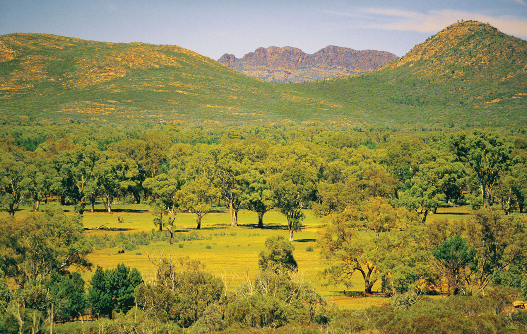
The toughest walk in the Wilpena Pound area is the St Mary Peak Hike. At 1171m, St Mary is the highest mountain in the Flinders Ranges and is significant in the Adnyamathanha creation stories. For this reason they ask that walkers turn around at Tanderra Saddle (over 900m high) rather than continue to the summit. The views from the saddle are still magnificent. You could turn around here and walk back down to the visitor centre (about 7km) but to be truly immersed in this extraordinary landscape, you should walk into its very heart. This loop walk lets you experience a variety of Flinders landscapes, from scrambling over its red rock bones to walking through native pine forest and open grassland, and meandering along a lovely creekbed and shady red gums near the visitor centre.
Rangers recommend you start this hike no later than 9am (10am during daylight saving) and take plenty of water. You can make this a two-day hike by camping at Cooinda Camp but note that this campsite has no facilities.
Banrock Station Wetlands
Distance: 8km circuit Time: 2–3 hours Difficulty: Easy
Banrock Station is a winery on the Murray River floodplain near the small town of Kingston on Murray. Since 1994 the owners have worked to restore more than 1500ha of wetlands and woodlands by planting thousands of trees, removing livestock and exotic species such as European carp, and establishing a more natural wetlands regime of wet and dry cycles.
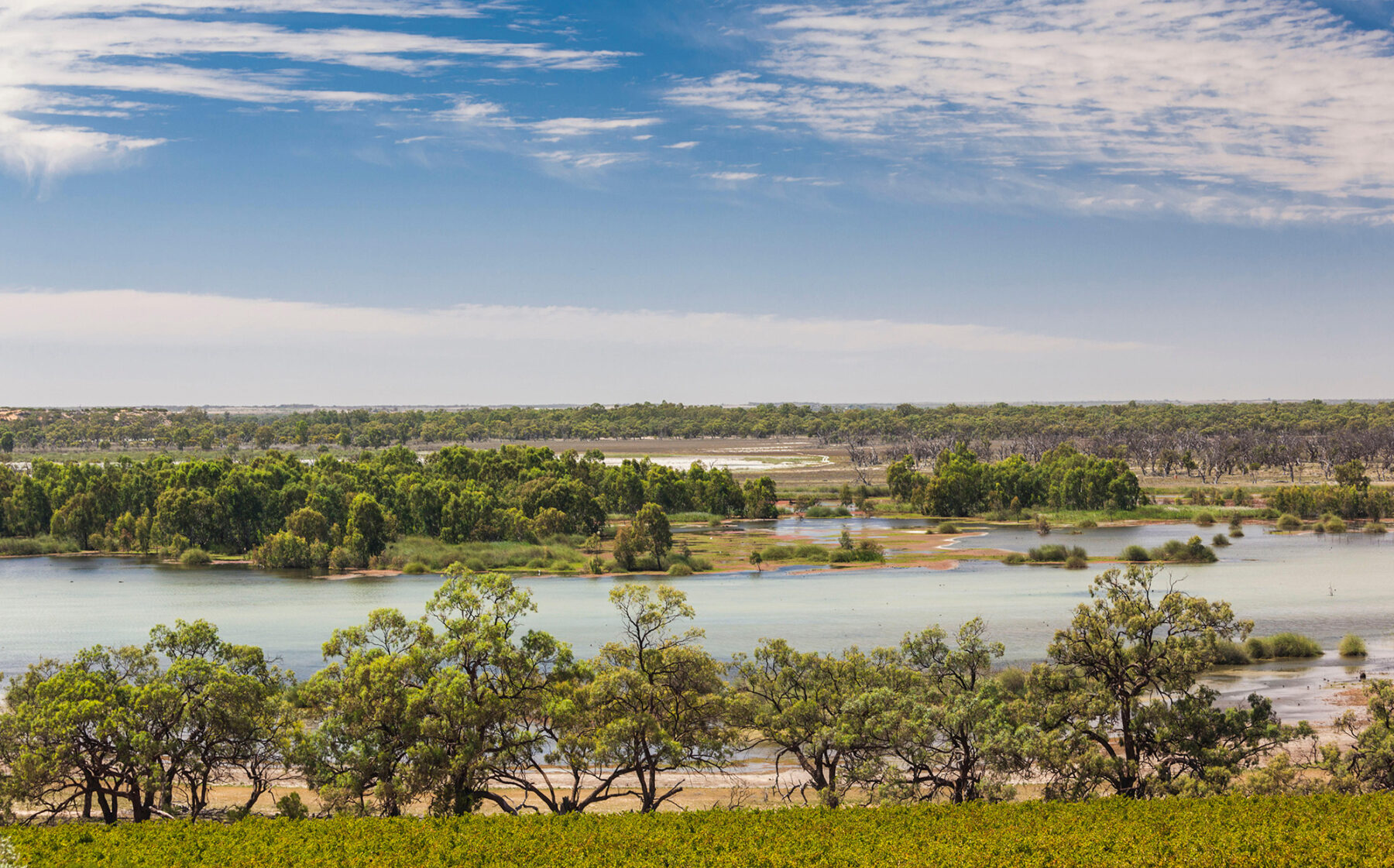
By 2002 the wetland had been listed under the Ramsar Convention as an internationally significant habitat and refuge for migratory birds and other wildlife. More than 310 flora and 250 fauna species have been recorded here. This boardwalk loop through the wetlands is superbly tranquil and a wonderful way to observe the abundant birdlife as there are several hides.
As it’s a winery, there’s also an excellent restaurant and cellar door to enjoy.