Walls of Jerusalem Circuit, TAS
Tasmania’s Walls of Jerusalem National Park is one of the world’s most overqualified World Heritage sites and forms part of the larger Tasmania Wilderness World Heritage area. This area encompasses 1.38 million hectares and includes Cradle Mountain-Lake St Clair, Franklin-Gordon, Southwest and Hartz Mountain national parks, as well as Adamsfield Conservation Area and the Central Plateau Conservation and Protected Area, with numerous hikes found inside this immense area.
As well as its natural highlights – glacial-carved valleys, ancient pencil pine forests, alpine lakes and dolerite peaks – Walls of Jerusalem NP is a famous bushwalking destination, with the park’s 518,000 hectares offering hikes ranging from day-long, to overnight, to a six-day (or longer) circuit, exploring the park from north to south and back again. To appreciate the wonder that is “the Walls”, a six-day circuit of the park is a must, albeit one for experienced walkers. Ideally, you will have completed other full-pack multi-day treks and be comfortable carrying your food and a day’s water (there are ample places to refill) plus all your gear. You will also need to think in terms of time, rather than distance, owing to the terrain encountered during this circuit and its side-trips.
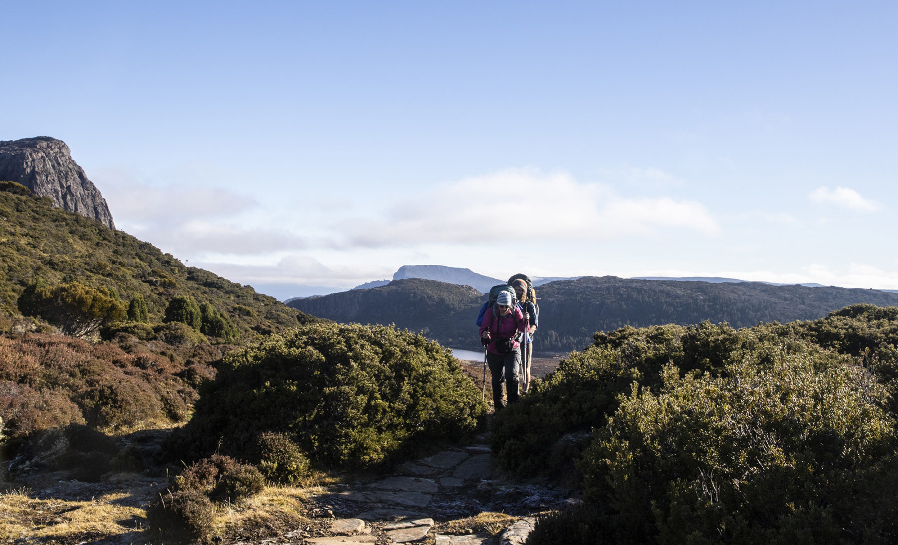
The Walls of Jerusalem circuit is far from subtle in its introduction to the park’s landscapes. The initial ascent begins straight from the Fish River car park (around three hours’ drive southwest of Launceston, via Deloraine and Mole Creek); following the rock-strewn track upwards immerses you immediately in dense forest, with towering eucalypts and lush tree ferns bordering the track. You will ascend 500m to the park’s boundary line, which is just above Trappers Hut, one of the area’s historic huts.
Once you reach the park boundary you will come to the junction of Walls of Jerusalem Track and Junction Lake Track. This junction point is where you start and finish the circuit. You can opt to go south on Junction Lake Track and complete the circuit anticlockwise, but we’d recommend turning southeast onto Walls of Jerusalem Track first – you want your intro to the park’s many natural highlights to happen on the first day.
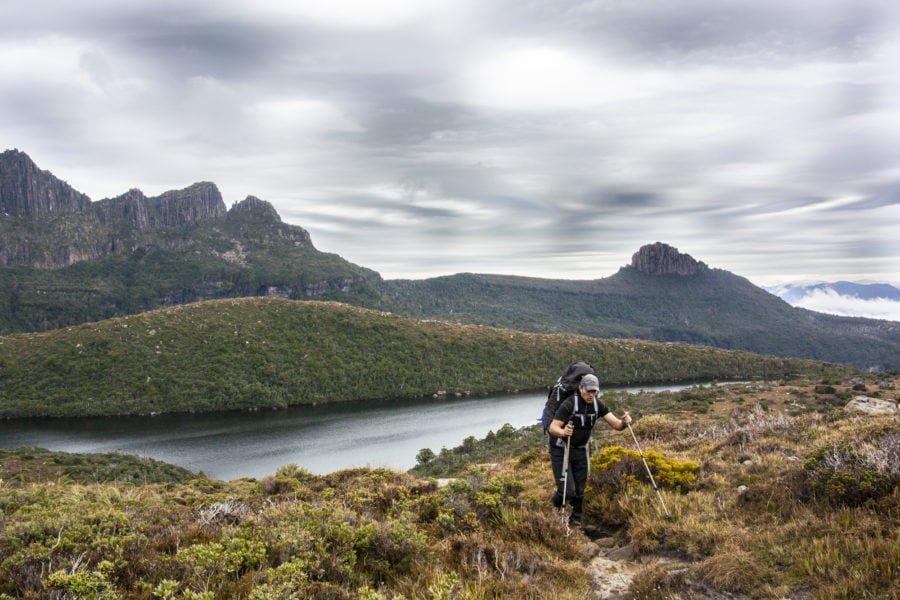
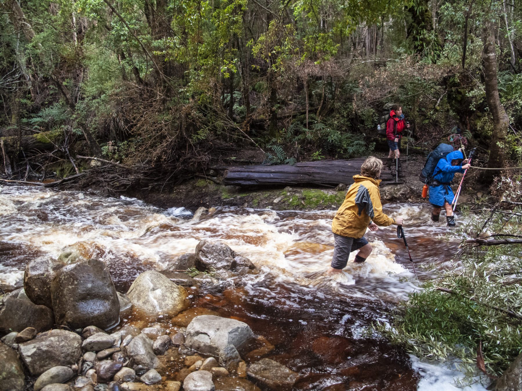
You are now at around 900m altitude and soon move from the dense timber onto the Central Plateau and the first of the circuit’s highlights. Solomons Jewels is an area dotted with small alpine lakes bordered by native pine trees. The traverse of Solomons Jewels is straightforward and followed by a short ascent to Wild Dog Creek campsite, perched at the base of King Davids Peak (1499m and Tassie’s tenth highest). The campsite has raised tent platforms and there’s a self-composting toilet 50 metres further up. There is also water here (boil before use). It’s a three- to four-hour journey from Fish River car park to Wild Dog Creek campsite and once there you can relax and enjoy the sunset over the lumpy peaks of Howells Bluff and Clumner Bluff.
The area of the park that encapsulates the actual Walls of Jerusalem is worthy of a full day’s exploration, and is deserving of its “The Amphitheatre” moniker. You enter this natural arena via Herods Gate, a 20-minute climb from camp. Once through you are immediately confronted with the area’s immense scale; towering dolerite cliffs of the West Wall shadow walkers as they traverse slightly undulating terrain, following Walls of Jerusalem Track. Highlights include Lake Salome and the pristine Pool of Bethesda. It’s a 1.5-hour traverse before ascending Damascus Gate and reaching the trailhead of two side-trips: an ascent of Solomons Throne, at the junction of the West Wall and Wailing Wall, and/or The Temple, to the east. We’d opt for Solomons Throne; scrambling up a scree field, then climbing through a square-edged notch cut out of the West Wall sees you at the summit of Solomons Throne, with 360-degree views over the park. Take in the Great Pine Tier and Bernes Valley to the southeast, Mt Jerusalem to the east, Chinamans Plains to the south and Lake Adelaide to the southwest. Return to Damascus Gate junction and continue southeast to your next camp at Dixons Kingdom Hut. This is reached after an hour of walking along an undulating track that leads through an emerald-green wonderland of grass and native pine trees before entering a clearing beside the hut.
Dixons Kingdom Hut is where the track to 1459m Mt Jerusalem is accessed. This steady ascent is about an hour (one way), and takes you over plenty of the rocks and boulders synonymous with the park, past alpine tarns, and over false summits before you reach the cairn marking the true summit. The views – especially the myriad lakes to the east – are outstanding.

Our circuit loops south then east, then south again over the next two days; the walk southwest through Jaffa Vale from Dixons Kingdom Hut is brilliant, with the chance to spot wallabies and birdlife hiding in button grass, before you turn east and follow Lake Ball’s shoreline. You then join Junction Lake Track at the head of Lake Adelaide. You can camp here or turn south to follow Lake Adelaide’s eastern shore to a campsite halfway down. This is recommended as it brings you closer to the following day’s objective: camping at Lake Meston and ascending Mt Ragoona (1350m). To reach Lake Meston from here it is two hours walking through what is claimed to be one of the world’s best examples of a glacial valley – Adelaide Plain – to camp at the head of the lake. Accessing the Mt Ragoona ascent is a via a side-track near Meston Hut (midway along the lake’s western side). The three-hour return trip (from the hut) is awesome fun, negotiating scrubby, then progressively rockier terrain to Mt Ragoona Plateau. The plateau is dotted with boulders and alpine tarns for the last hour to the summit and views of Cradle Mountain and the rugged ramparts of the Western Arthur Range.
From Lake Meston campsite it’s a full day to final camp at Stretcher Lake. Backtrack north along Junction Lake Track, past Lake Adelaide and then through more valleys to Stretcher Lake (via a 15-minute side-track). A short walk around the lake before sitting back to enjoy sunset makes a brilliant last night. It is three hours from camp to the car park. Rejoin Junction Lake Track, follow it to Trappers Hut, and descend to Fish River car park. Time it right and you’ll be enjoying lunch and a celebratory beverage at the Mole Creek Hotel – the perfect finish to six days in Walls of Jerusalem NP.
Cape to Cape Track, WA
The 135km Cape to Cape Track, linking Cape Naturaliste to Cape Leeuwin in WA’s southwestern corner, runs alongside the pristine Leeuwin-Naturaliste National Park, and is one of Australia’s most popular multi-day hikes.
The landscape walkers travel through is incredible: wind- and ocean-blasted headlands and sea cliffs, towering karri forests and beaches where, often, you will find no-one else on them. In short, it’s the perfect mix of coast and hinterland, with enough fauna and flora to keep the most specific nature-lover more than happy. Rock pools full of marine life, distant pods of dolphin and (in whale watching season) larger marine mammals frolicking in the waters of Ngari Capes Marine Park, (if you’re there at that time) the crazy colour-fest that is WA’s wildflower season, no matter the time of year, you’ll be spending more time looking off the track than watching where you are walking.

For experienced hikers, the track can be walked comfortably in a week or, if you have less time (or not the experience of fitness level needed), you can sample a few sections of it as day walks, with several roads providing access to different parts of this coastal adventure. If it was us, though, we’d take the full week; seven days on this track, admiring all its natural wonders, will take you far, far away from any stress and worries of your everyday life.
Even though the Cape to Cape hike is not as well-known as it probably should be, it is very popular with WA residents. This is not just because it is a cracking adventure, but also because Leeuwin-Naturaliste NP cops the most visitors of any national park in WA. To this end, we’d suggest starting that week-long trek from the northern end, so you get the busy tourist hub of Margaret River and surrounds out of the way first, and then focus on just enjoying this undulating route’s abundance of nature as you follow it along one of the world’s most magical sections of coastline.
Dusky Track, NZ
New Zealand is chock-full of any number of multi-day treks that would sit comfortably on a walker’s bucket list – it just boils down to how much of a (rewarding) challenge you want. Enter the mighty Dusky Track…
Deep, deep down in the wild southern section of Fiordland National Park, the 84km-long Dusky Track is one of Australasia’s most challenging hikes – and is for experienced, independent walkers only; there’s no cushy guided option here, folks, it is an epic undertaking. It is also one that pays massive dividends: you will be transported to one of the world’s most remote regions – most likely by float plane or boat – to tackle the journey from Lake Hauroko in the south, to the track’s northern finish point of Lake Manapouri. You will traverse some absolutely crazy terrain, ranging from low boggy floodplains to high ridges and mountains, while negotiating 21 three-wire bridges across creeks and rivers, and – most likely – slogging for at least one day through deep, boot-destroying mud along a rough, barely formed track. In other words, it is a real adventure!

The Dusky Track will, at an absolute minimum, take you eight days. But make sure you pencil in another two days at least to allow for any weather delays; high rainfall means flooded track sections, which in turn means extended stopovers at huts. Then, add another two for the not-to-be-missed optional side trip to Supper Cove, on Dusky Sound. Yep, that’s 12 days. And you’ll need to be fit and strong as you will have to carry all your food, clothing, sleeping and cooking gear in your pack – there are no food drops here. Like we said, it’s an epic undertaking.
The Department of Conservation (DOC) huts are relatively basic but offer the required shelter and are a welcome sight after a day on the track. The days are long, but time is forgotten here as you focus on negotiating the terrain, checking out the incredible views and, most importantly, soaking up the entire enriching experience. Not all who venture south to attempt the Dusky tackle the side trip to Supper Cove but, the way we see it, if you’re going to be heading to a place that is so remote, and you’ve seen some of the brilliant photographs of the cove itself, you will put your head down and just do it.

For all this ruggedness and long distance, the Dusky has earned its place on this list for one simple reason: there’s nothing else quite like it in our part of the world. And if you ask anyone who has done it what their opinion is, you will probably be surprised at both their passionate recollection of their experience, and their comment of, “It was tough and challenging, but I’d do it again tomorrow if I could.” It’s amazing how venturing into a true wilderness can affect people…
Note: You will need to book transport to the start of the track and organise being picked up at the end. Plus, you will need to purchase DOC Hut tickets. For info on all of these and more, see the NZ Department of Conservation at www.doc.govt.nz).
South Coast Track, TAS
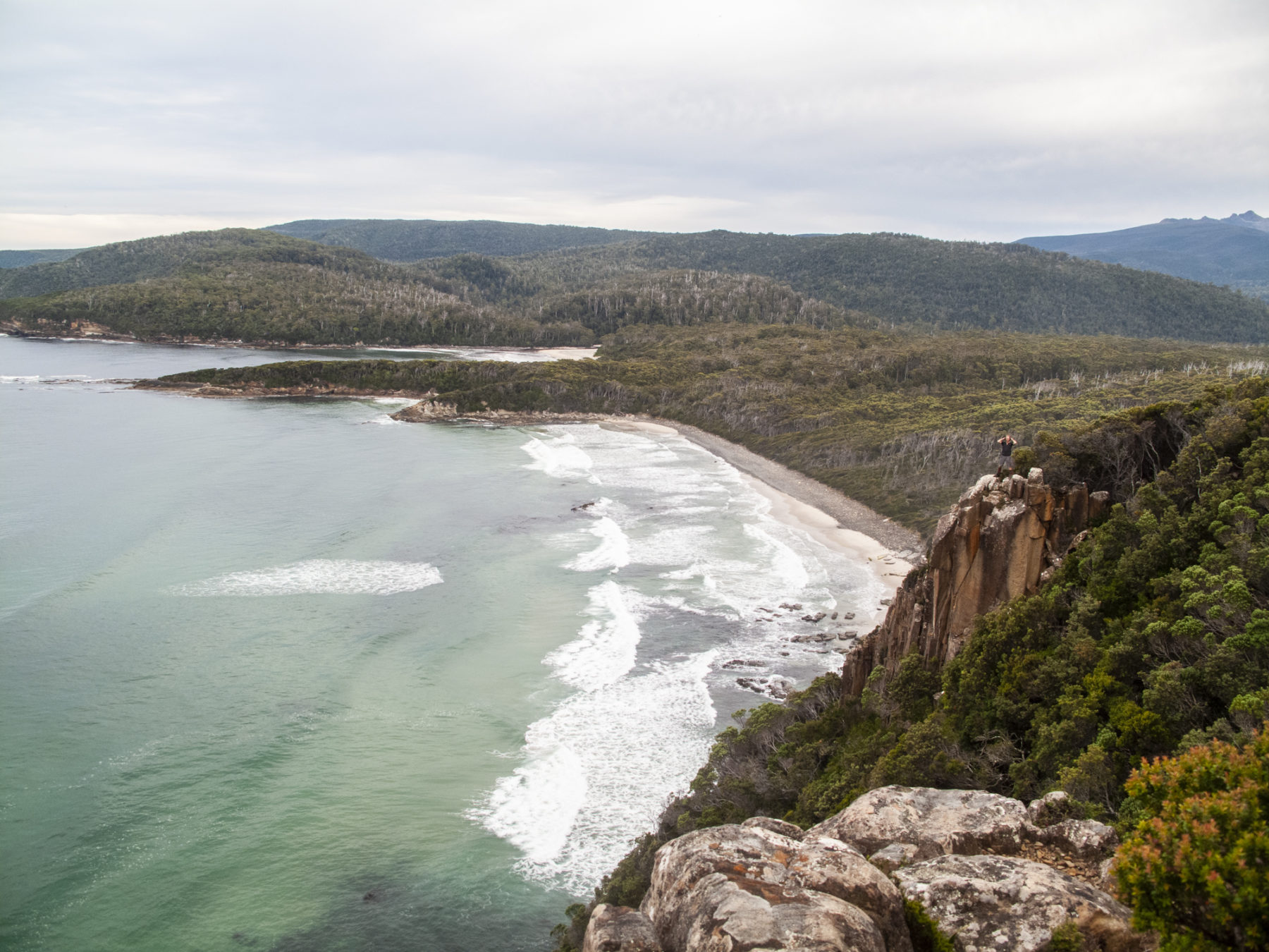
A truly remote experience, the South Coast Track, down at the bottom of Tassie, is one of Australia’s best multi-day walks. Access is via plane, landing at Melaleuca, and then it is six-eight days – and 85km – in the wilds as you follow the SCT from Melaleuca through some of southwest Tassie’s most spectacular terrain, to Cockle Creek.
The weather this far south is volatile and unpredictable – you will need to be fully prepared for all conditions. No matter what time of year, you need to be ready for everything from wild storms and six-degree Celsius daytime temps, to warm, sunny days. The track is (in)famous for its muddy sections, some of which will see the unwary walker sink down to near-waist level, so be prepared for wet, muddy gear (especially boots/socks).
The first few days are a great intro; walkers experience deserted beaches, thick rainforest, river crossings (and a boat crossing) and sublime campsites. Then, midway, it is the big one: the crossing of the Ironbound Range, a full day climbing from sea level, up to over 1000m, and then back down to the beautiful Deadmans Bay campsite overlooking the Southern Ocean (a perfect base for an optional rest day). This day will test your trekking fitness but reward you with either amazing vistas (on a clear day) or a memorably wild buffeting from wind or rain up on the exposed top if the weather is not cooperating. Either way, it is a memorable experience. And the South Cape Range (around half as high as the Ironbounds) is nearly as much fun.
Tasmanian Expeditions runs guided walks on the SCT but that still requires walkers with experience in remote multi-day treks. There are no huts on the SCT – you need to carry all your gear and food the whole way – and the track is challenging, but all this effort is more than worth it. The SCT has earned its reputation as a top trek for a very good reason: it is simply brilliant.
Routeburn Track, NZ
Yes, the well-known Milford Track is right next door, but for those looking to jam in the most of NZ’s Southern Alps landscape – mountains, fast-flowing alpine rivers, or beautiful beech forests of multiple shades of green – then the 32km, three- to four-day, Routeburn Track, traversing two of the Shaky Isles’ most famous national parks, is the best of NZ Depaertment of Conservation’s (DOC) 10 NZ Great Walks.
The Routeburn can be walked in either direction: from Routeburn Road end, in the east (accessed via the mountain town of Wanaka), to The Divide or vice-verse. Either way, you’ll be gobsmacked by the landscape within minutes of hitting the track. At 32km, you could, theoretically, complete the Routeburn Track in two days, but that would be a disservice to the track and yourself; it’s a truly wild part of NZ and well worth savouring.
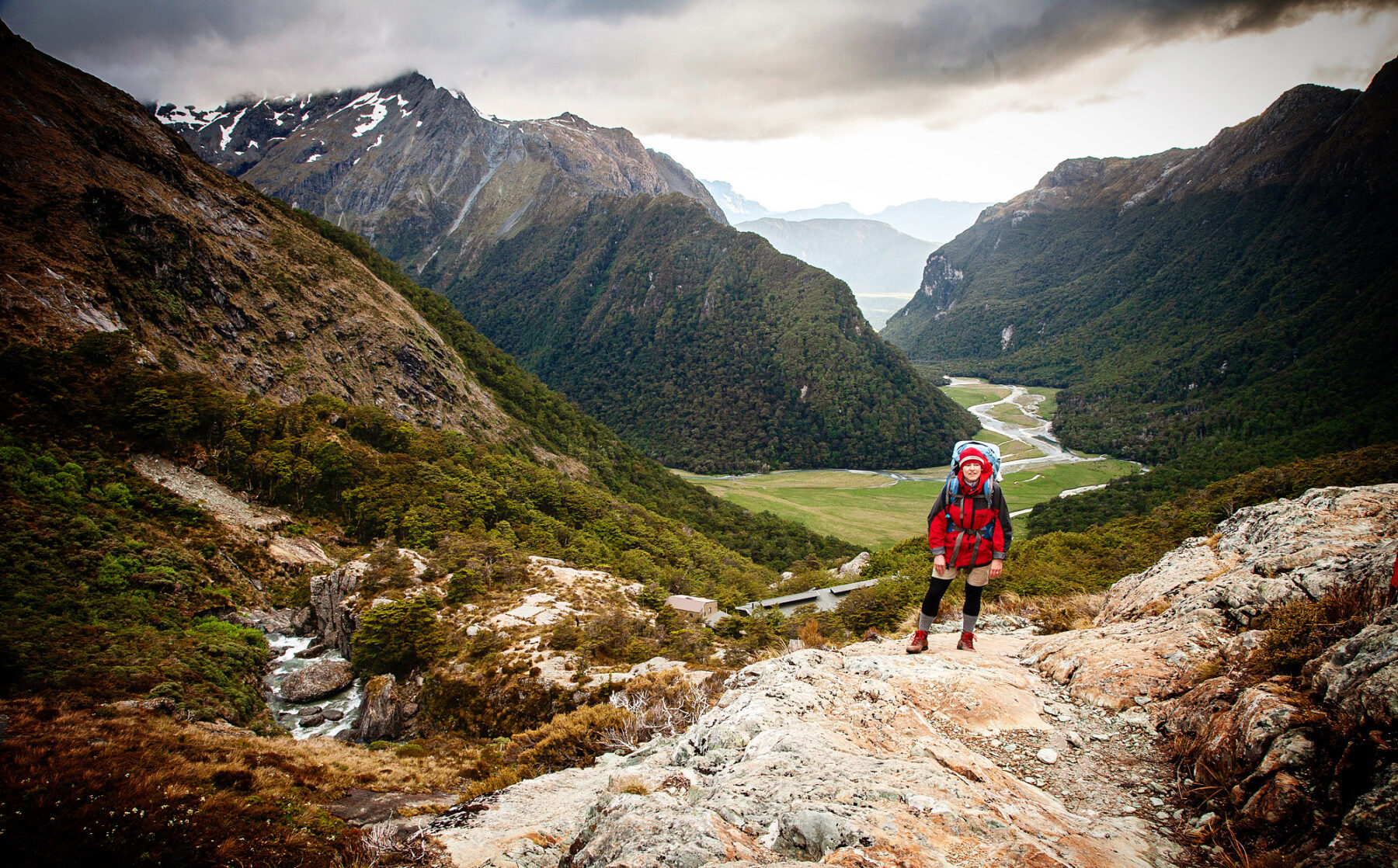
Our preference would be to start from the eastern point at Routeburn Road, inside Mt Aspiring National Park, and get the big climb up to Routeburn Falls Hut out of the way on day one. The Falls Hut is probably one of the most dramatically situated of the DOC backcountry huts, perched high overlooking the river valley (and Mt Somnus) below, with a waterfall running down one side of its location.
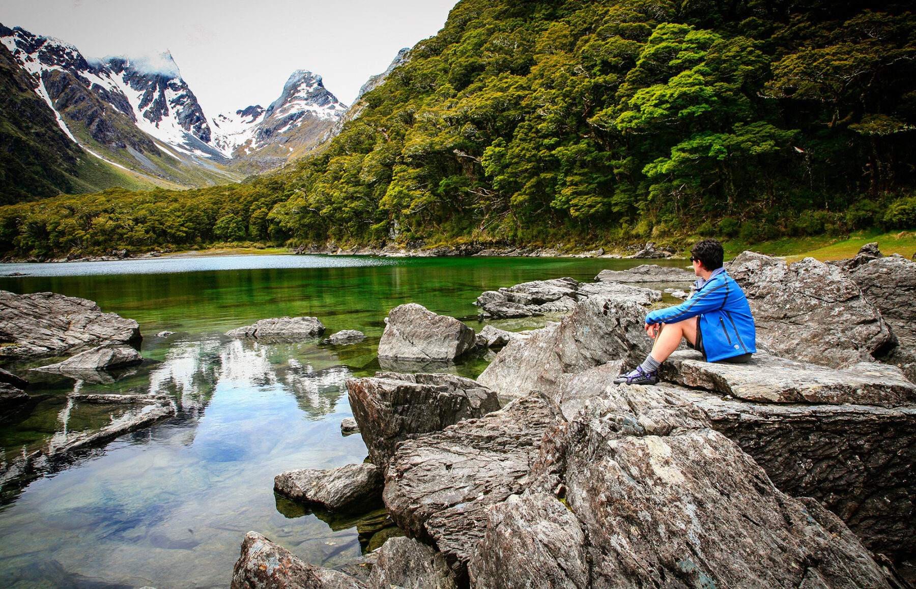
The second day on the Routeburn Track is spectacular: you continue climbing to Harris Saddle (passing Lake Harris along the way), before winding your way along the (near) top of the Serpentine Range, with views of the Hollyford River valley, before descending to Lake Mackenzie Hut, another beautifully located hut.
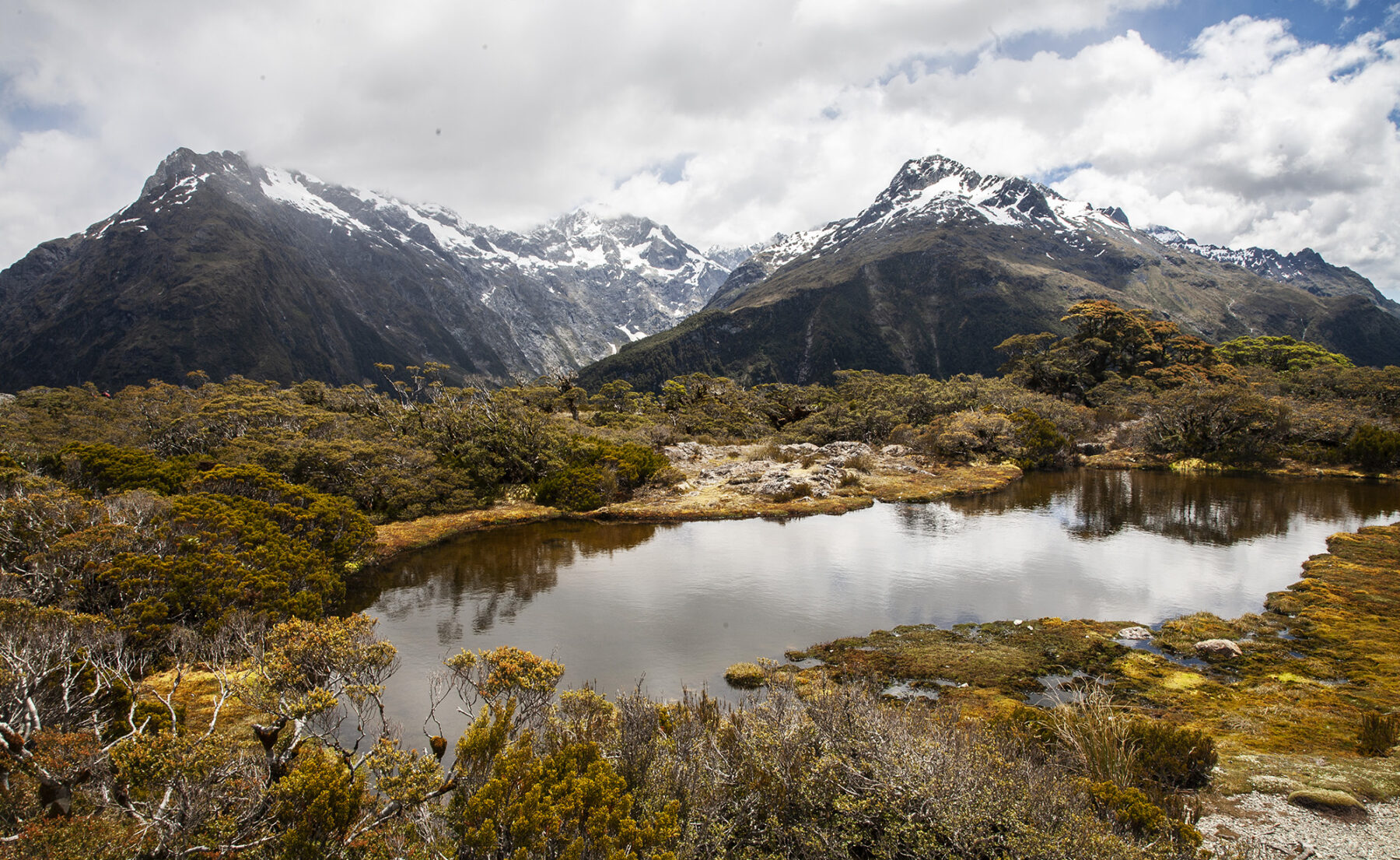
The final day involves an initial climb, passing Earland Falls on the way, before descending to Howden Hut and then climbing up again to The Divide 9the Routeburn’s end-point and where you meet your track transport). One side track not to miss is the one to Key Summit. The turnoff is 15 minutes climb up from Howden Hut and when you arrive at Key Summit (1.5-hr return walk) you get awesome views of the Darran Mountains. The track is well graded throughout with only a few short rocky sections, and the Great Walks huts (for independent walkers) are brilliant (gas stoves and wood heating, plus bunk rooms).
As long as you’re well prepared for the region’s oft-changing weather (and remember to book your hut tickets well in advance; Great Walks booking season opens July 1), the Routeburn Track is perfect for those just getting started on multi-day treks, and adventurous families; children from 10 years of age upwards easily handle this walk. If there’s one world-class track we’d recommend for introduce the family to the joys of multi-day trekking, it’s the Routeburn Track.