
“Gardens of Stone,”, I said, in that gravelly voice used to denote post-apocalyptic wastelands in Hollywood movies.
“Gardens of Stone,” came the reply, rough as metal files rasping across a tombstone. Paul knew there was only one way to intone the name of a national park with such a primordial and weighty name.
“Gardens …” I whispered, like the souls of a thousand golems howling in a sandstorm, “… of Stone.”
Our conversation, if you can call it that, was somewhat premature in its clumsy expression of awe. We’d only left Baal Bone Gap, a wooded notch in the escarpment, half an hour beforehand. Yet awe was not long in coming; as we crested the cliff line we immediately knew the reports of its beauty had not been exaggerated.
Technically, we’d started walking twelve hours ago. The Moffitt Trail was described on NSW Parks signage as ‘4WD recommended’. Clearly, whoever wrote that must have had some sort of 2WD tank, because we abandoned Paul’s Corolla when the cracks in the trail began to resemble the nearby Bungleboori canyons in width and vertical gain.
There followed an 11km hike under the moonless, starlit sky. I hadn’t known Paul long, but immediately thought of inviting him on this trip as he a) owned a car, b) owned a rope and knew how to use it, and c) had recently been made redundant and was up for anything. The drive up had established his appalling taste in music, and that he’d spent a lot of time in prison (albeit working there). The universe’s timing was impeccable though, as my oldest friend and regular adventuring partner had recently left Sydney. Thus, by massive coincidence, one Cornish, shaven-headed, ginger-bearded, hiking buddy called Paul was replaced with another.

Once you get over the feeling of being continually watched, night walking reveals its own pleasures: the silence; the noise; the eerie floating light that never gets any closer or further away. We bivvied near Baal Bone Gap picnic area shortly after midnight, reasoning the mantle of darkness would render this section, through Ben Bullen State Forest, entirely new and different on the return journey, making it less of a slog back to the car. We were wrong, of course.
Into another land
Our first view of the Gardens of Stone was enough to stop us in our tracks. Well, that and the looming cliff edge. Beyond the precipice was a vast green bowl, girt by vertiginous cliffs and split by Crown Creek. The tangled horizon of buttes, escarpments, and scooped valleys was smudged by an early morning haze, the varying shades of which aided our depth perception by outlining the delicate tracery of each geological feature.
Having absorbed this panorama until we were guaranteed to dream of jigsaw pieces, Paul Mk. II and I picked our way along the edge of the abyss, clambering over logs, through bushes, into tree limbs, and around the pagodas for which the park is famous. Bulging, stepped, beehives of sandstone sculpted over thousands of years by the action of wind and rain, the pagodas’ distinct shapes are created by bands of ironstone, hardened sandstone laden with minerals, which don’t erode as fast as the regular sandstone does. The result is stacked ‘plates’ and tongues of ironstone licking out into space, flowing shapes that look more at home in clouds or swirls of spilt paint than solid rock. A globally significant geoheritage, the formations are unique to an area of roughly 55,000 ha northeast of Lithgow.
It wasn’t long before the park’s main attraction took centre stage: the freestanding plateau/mesa/butte – call it what you will – of Pantoney’s Crown. A flat topped mountain surrounded by cliffs, Pantoney’s was formed as creeks and rivers eroded the sandstone surrounding a 500 million-year-old limestone outcrop, leaving it standing proud of the valley like a tree stump. William Lee Pantoney, the son of two ex-convicts, established sheep grazing in this area in 1823, raising a family here. Looking out over the vista, I tried to imagine this being my childhood backyard. No world heritage listing, no park status, just a remote property on the fringes of the colony. Life may have been hard back then, but what a place to live!
With the Crown hogging the limelight, I was surprised to note some other picturesque inselbergs. Mt. Canobla and Mt. Gundangaroo, 15km to the NE, were equally beautiful, and I immediately earmarked them for a future trip. Walkers are welcome to roam anywhere within the Gardens of Stone NP, although there is no signage and little in the way of paths or tracks. The weekend was to be an exercise in navigation, as well as scrambling and water rationing. The Capertee Valley lies in a rain shadow, and we’d each begun walking with around six litres of the wet stuff.
A couple of hours of cliff edge yomping brought us to Baal Bone Point. This wasn’t a witch-doctor’s curse, but a precariously balanced pile of boulders forming a promontory projecting northeast into the valley, part of the rocky spine that arches through the valley like a fossilised sea monster. Baal is a Wiradjuri word for ‘water’ or ‘drink’, referring to the creek running down from the Gap, and Bone was added as a directional aid.
It was from here we were supposed to descend, but how, exactly? The only way was a steepening rivulet of stone, down which we gingerly slid until aided by a well-placed log at the final vertical drop. From there, a faint footpad guided us down to the saddle, where it blithely abandoned us. The ironbark and box woodland here, and the coachwood and sassafras further up, was dry as a dirty martini. Dead limbs crackled under our boots like burning witches, a macabre premonition of the bushfire devastation that would sweep through the area a few months from now. By the first day of 2020, 65 per cent of the park had burnt.
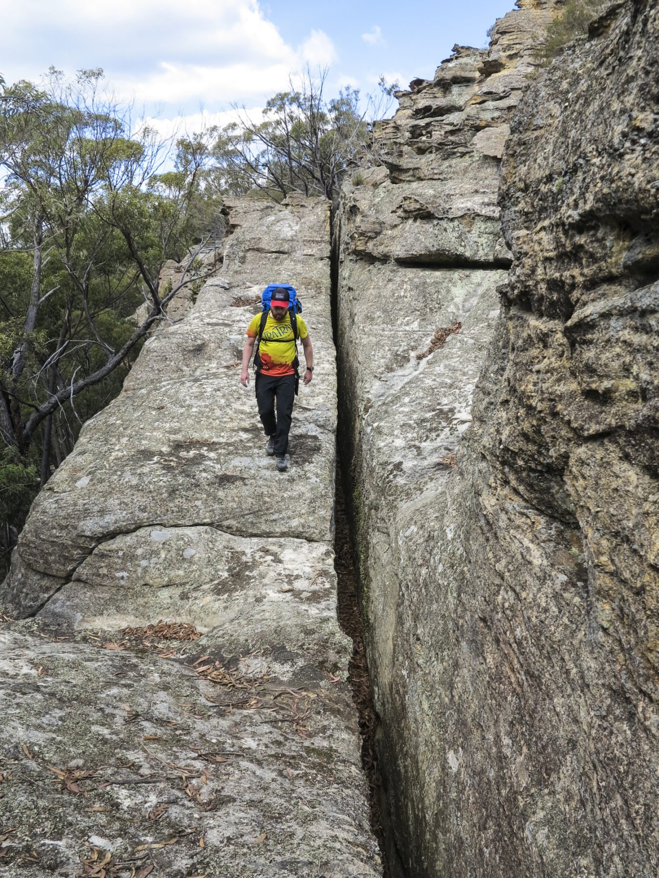
Some of the trek involved negotiating some high narrow rocky sections. 
More than a room with a view, making the scramble well worth the effort.
Now directly beneath Pantoney’s nose, we were able to navigate up the philtrum by sight. Once at the columella, the route plunged deep into one of the nostrils. This was the part of the hike I’d been most nervous about, navigating this treacherous scramble, but fortunately the way was marked by cairns and worn rock. It was a simple matter to clamber up the cleft, aided by generous handholds, although the exposure was not inconsiderable and we hauled our packs up separately rather than risk them peeling us off the rock face on the gnarly corners.
Having scaled the final chimney, we were met with a revelation – the plateau that looked flat from a distance was actually anything but. What confronted us was a maze of towering pinnacles, thick scrub and piled deadfall. I was reminded of Roraima in Venezuela, the flat-topped mountain that inspired Conan-Doyle’s The Lost World, and Pixar’s Up. This was Australia’s own mini tepui! The final kilometre to the summit cairn was guarded by a dozen rearing pagodas which we scaled with care; their intricate formations vulnerable to damage beneath the boots of careless hikers.
What lies beneath
Neither fire nor recreational activities are the Gardens’ greatest danger. The current National Park spans 11,780 hectares, gazetted in 1994. A further 3,600 ha were added to Wollemi NP the following year, but the rest remains unprotected, and it’s these areas which face more nefarious threats, with by far the most worrisome being mining.
Ever since the late 1800s, the area had been used for shale mining – extracting shale oil from oil shale (yes, a tad confusing). The oil shale was distilled above ground, but the process was prohibitively expensive and the refineries didn’t last long. Coal mining, however, which started around the same time, has been, and continues to be, much more destructive. With the area resting within the extensive Western Coalfield, the industry has continued to thrive well into the 21st century.
Today there are three mines operating in the Lithgow area, with a handful more under Care & Maintenance, i.e. operations temporarily suspended. All three are longwall mines, a process that follows the coal seam underground. As deposits are extracted, the rock above naturally collapses to fill the void, causing subsidence, surface erosion and, in this area, the collapse of precious pagodas. Water is another issue: the mines currently take approximately 25 megalitres per day from the Newnes Plateau to rinse the coal, leaving its swamps parched and dying. The washeries pump the used fluid, sometimes still contaminated with salt and heavy metals, back into the water catchment. Apart from anything else, the redirection of natural flow paths from groundwater seeping into the disrupted bedrock can have a hugely negative impact on plant and animal species.
Local environment groups are campaigning to protect the 39,000 hectares of ‘Destination Pagoda’ as it is being marketed. Known as the Stage 2 Reserve Proposal, the goal is two State Conservation Areas, the Gardens of Stone and the Western Escarpment, centred on Newnes Plateau. According to NSW National Parks, “State Conservation Areas are lands reserved to protect and conserve significant or representative ecosystems, landforms, natural phenomena or places of cultural significance.”
In this case, responsible underground mining would be allowed to continue in the area, but the new status would promote best practice environmental protection, such as adequate water effluent treatment and subsidence management planning, which would protect the most spectacular pagoda formations. It’s not perfect, but until fossil fuels become economically unviable, it’s the most protection the area will get.
A part of the Gardens of Stone
In the time it took to turn slowly through 360 degrees, in order to fully absorb the view from the summit cairn, Paul v2.0 had slipped into a coma from which he wouldn’t awaken for twelve hours. So much for the draw of globally significant geo-heritage! “Original Paul would never have done this,” I muttered at the man’s prone doppelgänger before setting off to watch the day die. The sinking sun ignited the horizon as I seated myself between bunches of frail pagoda daisies. Only a few patches of artificial light glowed in the valley, and the silence was absolute. Despite this being an internationally recognised bird watching area, with local stars including the regent honey-eater and powerful owl, we’d made no feathered friends today. In the backyard of koalas, quolls and yellow bellied gliders, we’d seen no animal larger than an ant (although those bull ants can be quite hefty!).
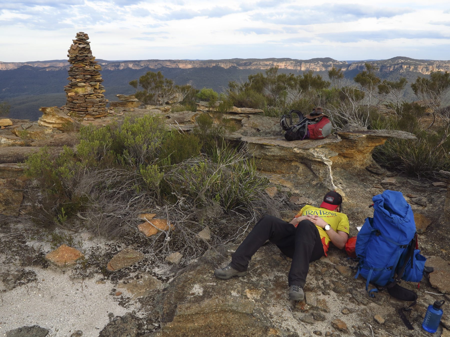
Tomorrow would be a long day, descending the northeast spur of Pantoney’s and down to Crown Creek Fire Trail, part of the Bicentennial National Trail. This track runs steeply up to Baal Bone Gap, from where we’d retrace our steps to the car. For the moment though, I sat and bathed in the absolute stillness. It’s not easy to feel completely alone in this overcrowded world, especially as a resident of the country’s biggest city with only a weekend to play with, but that evening, perched atop a pagoda, 300m above the valley floor, I truly felt alone.
“Gardens … of Stone,” I whispered, as the sky caught fire. The breath of my exhalation brushed the sandstone, colliding atoms contributing infinitesimally to its continued sculpting. And with that, I became part of the landscape, forever.