It was hot. It was steep. It was dry. And if you didn’t actually know where you were, you wouldn’t believe it was southwest Tasmania. For the first-time visitor to this region, the typical images of lush green rainforests, huge rivers and towering, shady gum trees would have been quickly vanquished from your mind.
As you stepped from the air-conditioned bus into the heat, and then started up a spur that was exposed to a searing sun seemingly hell-bent on frying you alive, you’d have thought you’d entered a grim, alternate world. For this repeat visitor, the hot and dry start to Tasmanian Expeditions’ four-day Mount Anne Summit trek was not unexpected – and nothing to be feared. Like the weather (more on that later), the terrain in this region changes unexpectedly, keeping you, literally, on your toes all the time.
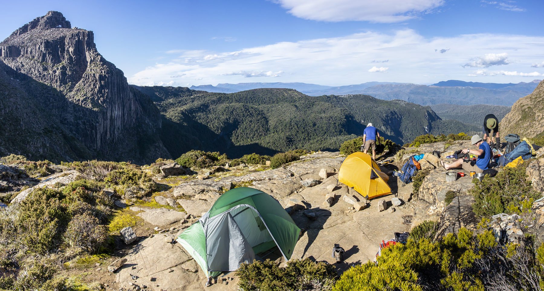
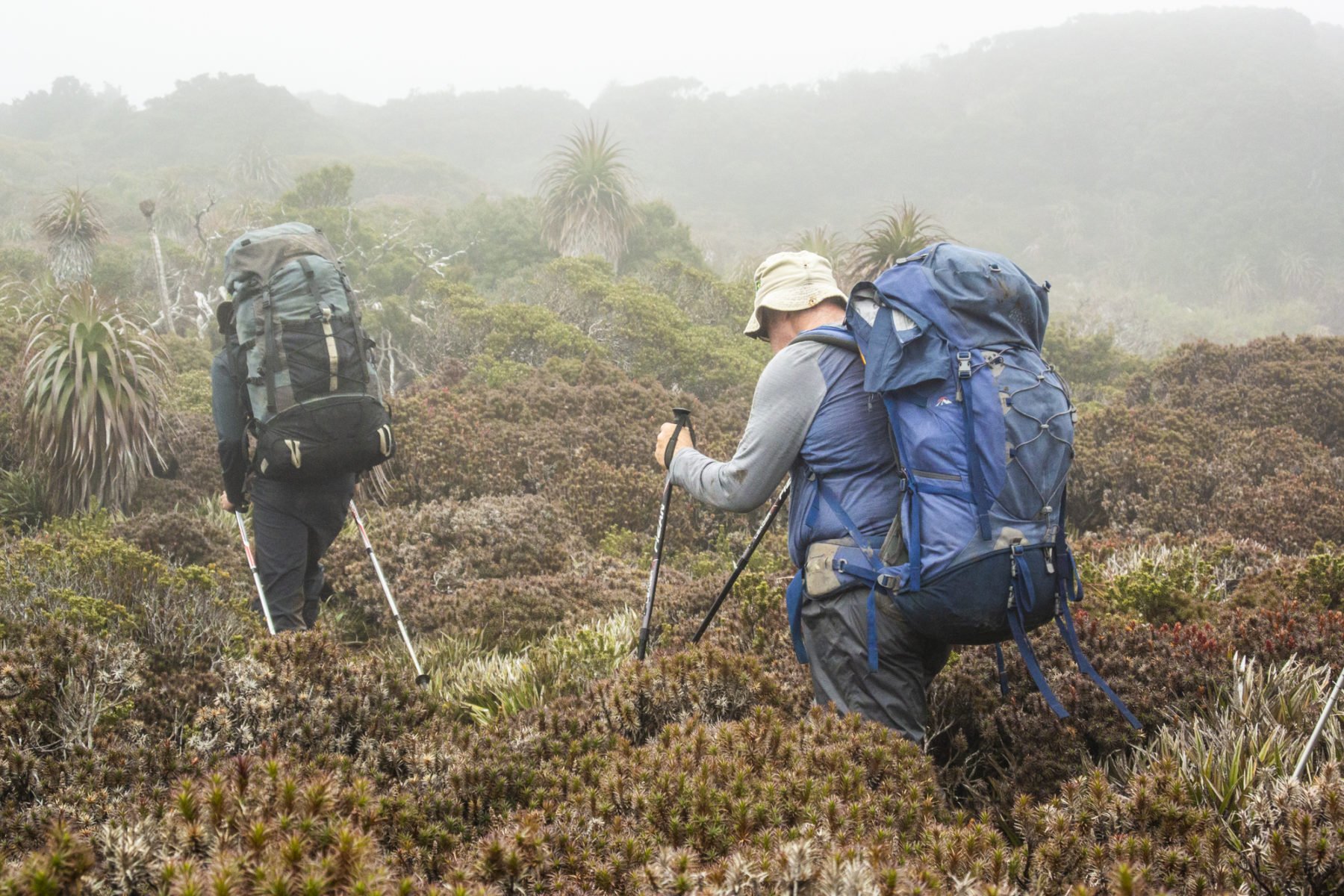
Waxing lyrical about the charms of Tassie’s volatile weather doesn’t make climbing 750m in the heat any more fun. But as my companions (Daniel, Duncan, Roger, John and Antony, plus our two guides, Simon and Jake) and I made our way up the spur to our first-night digs at High Camp, any distraction would suffice.
And there were plenty; as we climbed, we could see more and more of rock-covered Mt Eliza, looming high above the ridgeline that housed High Camp. Below sprawled the huge expanse of Lake Pedder; its cold waters an enticing tease as we sweated uphill in the heat.
It’s an abrupt and testing introduction to the circuit. But not abrupt enough, apparently, for Simon – or me, John, Daniel and Duncan, who all pipe up with a big “yes” when he suggests a scramble to the top of Mt Eliza, sans packs.
We must have been suffering severe short-term memory loss in regards to the just-completed climb, or perhaps it was the timing of Simon’s question, right after the euphoric feeling of removing our 25+kg packs from our backs and dropping them to the ground.
The scramble itself was brilliant; the boulders dotting the side of Mt Eliza are immense in size but extremely tractive underfoot, allowing steady progress up the side of the mountain. It was only an hour before we topped-out and were rewarded with both exhilarating views across most of the southwest of Tasmania, including the jagged spires of the Western Arthurs, and a preview of the next day’s track.
The Mt Eliza Plateau spread out to the east, with the track winding through and around alpine tarns and a multitude of rocks and boulders, on its way to Mt Anne in the far distance. It was a true alpine wonderland that ramped up our collective enthusiasm for the days to come – enthusiasm that was slightly dented on our return to High Camp.
Roger and Antony had stayed behind at High Camp with Jake while the rest of us had done the Mt Eliza scramble; both had been a bit slower up the mountain but, as it was not a race, I had thought nothing of it until we got back to camp, where we found out things were slightly more serious. Both men had previously suffered pretty serious lower back complaints and this first day’s strenuous start – and the heavy packs – had aggravated these injuries. They were both tender on their feet and were mulling over whether to continue or not. It was not an easy call to make so both decided to sleep on it, hoping the rest would help reduce the pain.
To the top of the world on the Mt Anne Circuit
The decision to turn back is never easy. Unless it concerns your immediate health in a very remote area, and you know the potential hazards that lay ahead. Then the decision you make has to be the right one. Which is what Roger and Antony did the following morning. Neither of them felt any better so they decided to return to the track starting point (with Jake accompanying them) to rendezvous with the Tas Ex bus (Simon had used a satphone to contact head office).
For the group, it was a bummer start to the day, but an understandable one. Having suffered serious lower back complaints in the past, I could sympathise with the pair’s decision and understood that it was the correct one.
So it was a slightly subdued group that made its way up Mt Eliza for the second time. Not only because of having to leave Roger and Antony but, with the extra weight of our packs on our backs – and the resulting change in balance and speed – it was looking like being a slower climb than the previous. Oddly, it ended up taking us pretty much the same time.
I guess familiarity with the route – and the fact we were moving quicker as a group – made the difference. After another brief stop on the summit, we started the traverse of the plateau, winding our way across undulating terrain with the track changing from sandy and gravel-filled, to muddy and boardwalk-covered, and passing a number of pretty, mirror-still alpine tarns, before traversing the first of what would be many boulder scree fields. And that’s when we really slowed down.
Taking a chance in Tasmania’s southwest
When you’re trekking in southwest Tassie, its notorious weather is always the governing factor. For us, the sun was hot but also much more fun to walk in than rain, wind or snow. So it was that, once we reached the junction of the main track and the side track to Mt Anne, we took our chance at the summit. And what a chance it was.
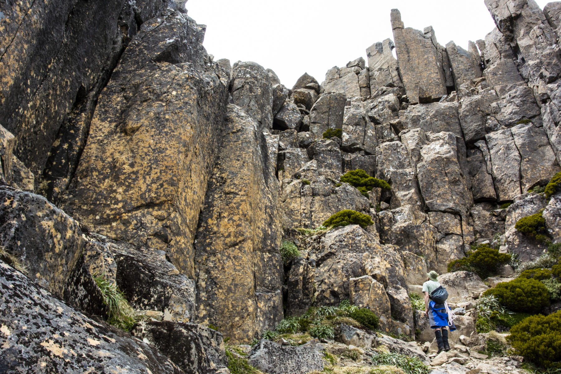
The boulder scree at the base of Mt Anne is slow-going but only the taster before the real challenge of scrambling and climbing – ropes and ascenders were used at one point – up often exposed sheer cliff sections before the final heave up to the flat-topped summit. It took us about an hour or so to get there and was drama-free. The return, however, was a little more exciting.
It was during the descent that Duncan proved that old adage that it’s always the quiet ones that surprise you. We had just watched Simon scramble on all fours across a flat rock that angled away to a rather long drop, doing this to avoid having to lean back and around an overhanging rock and potentially lose balance and take a big drop.
Duncan thought it might be better to try and hug said overhanging rock while sidling around it. His tiny, microsecond “dance”, as he momentarily lost his balance and leaned ominously back to the drop-off before collecting himself, definitely ranked as the trip’s, er, most unique moment. I have done a couple of trips with Simon as guide and never seen him quite so pale.
Dances and the descent over and done with – and Duncan as calm and collected as ever – we collected our packs and continued on to Shelf Camp, which would have to rate as one of Tasmania’s premier campsites. Impressively, Jake was already there – he’d dropped off Antony and Roger and then hightailed it back to get ahead of us –- and had the stove already boiling when we finally arrived at camp. The talk among the group (guides aside) was all about how “big” the day had been. How little we knew.
Time loses meaning on the Mt Anne Circuit
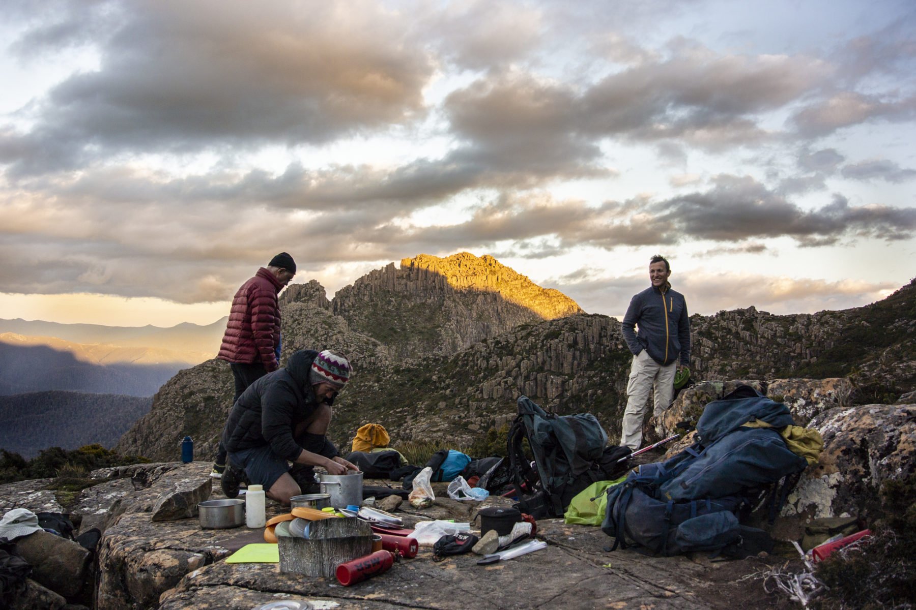
You could spend a week at Shelf Camp and not be bored. True to its name the campsite sits on a huge shelf, with panoramic views to Mt Anne in the east, Mt Lot and The Notch to the south, and a deep, deep valley right off the edge of the shelf. When we’d arrived the night before it was to be welcomed by not only a hot coffee from Jake, but also a sublime sunset, the day’s last rays adding a soft glow to some low clouds over The Notch.
The morning was no less entrancing and, again, foreshadowed another hot day ahead as we scoffed breakfast, packed up camp and starting moving toward a massive boulder scree field. The rocks of the scree field are immense – most would be the size of five adults combined at a minimum – and made for slow progress. We also had a fair bit of pack-hauling to do, lowering our packs down a few vertical drops before sliding down the ropes ourselves, and progress was measured in inches over the first part of the morning.

It is only when we cleared the boulder field, scrambling up a narrow track to look over the beginnings of The Notch, that we realised we’d only covered roughly 1km – and it had taken around two-and-a-half hours. Far from being disheartening, the feeling of achievement among us was pronounced; we’d all worked as a team when needed, following Simon and his huge backpack like a beacon through the cluttered boulder field, and enjoyed the experience of being in a unique and amazing landscape.
The Notch is just that – a near-perfect notch cut out of Mt Lot’s left side. We had to shimmy down a narrow, tight, slippery track to the base of The Notch itself, where we waited for Jake and Simon to free-climb the 15m wall on the opposite side to anchor some rope for us to climb up.
They added in an ascender for anyone not keen on the exposure (I took up that option without hesitation) then we hauled up all the packs and followed them up ourselves. It was a short climb, but the sense of all that empty space below was prominent with each hand- and foothold.
Back in the (un)real world
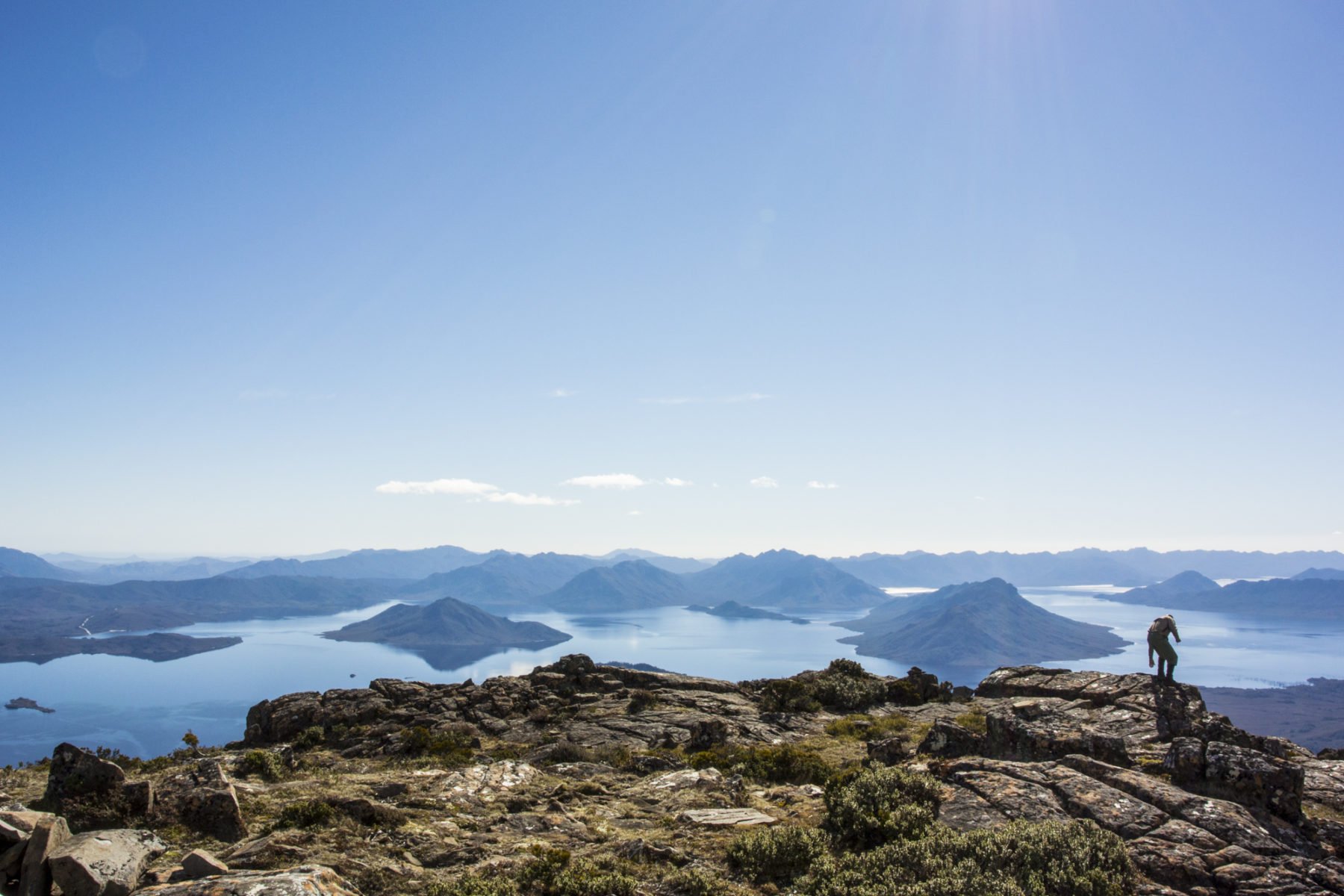
Viewed from afar, Mt Lot and Lightning Ridge look just like a jumbled series of steps. The rock pillars that make up Mt Lot – and the huge jumble of boulders that comprise Lightning Ridge – look sharp and impossible to negotiate when viewed from the side, in silhouette. It’s only when you’re up there – way, way up there – that you realise the knife-edge silhouette is relatively wide on top and, although steep and still quite exposed in areas, a challenging but not impossible traverse.
It all comes down to route finding, with small cairns dotted down the side of Lightning Ridge to assist in this. And then it is just a matter of scrambling, sliding and jumping your way from one boulder to another to reach each cairn – and then repeating the process slowly, all the way down to where the ridge meets the treeline. With high levels of concentration needed, it was easy to forget what lay below: a beautiful view of Judds Charm (our next camp) nestled next to a small lake to the left; and the large rich blue of Lake Judd spread out to our right.

It was a number of hours before we reached lower ground, where we were immediately to be engulfed by what looked and felt like prehistoric rainforest. Huge pandanus palms were everywhere, as were vines, low branches, massive ferns and a barely discernible track – it was like rediscovering a land long lost.
Finally breaking out from the dense rainforest onto the open ground of the moorlands near Judds Charm was surreal – especially when we stopped to look back at our previous hours’ efforts. From our low-down viewpoint, Mt Lot and Lightning Ridge once again looked insurmountable, but we’d nailed it; many hours and loads of effort over an incredibly huge day but with all of us in one piece and strangely energised.

Tassie stays true to form
Whenever anyone asks me how I handle trekking in Tasmania’s often wild conditions, where summer can be belting hot one minute and freezing cold and wet the next, I just answer with a “that’s what you have to expect, and that’s what I love the most about it”. So, I knew it had to happen at some point, and even though it was late to the party, the crazy Tassie weather arrived in all its fury just in time for our last full day.
Cold winds, black clouds, a heavy mist and freezing temperatures dogged us as we climbed to Sarah Jane Plateau. The plateau contained a few surprises, too: Simon found a pincer from a freshwater/alpine crayfish and we also nearly all stepped on a (small) venomous whip-tailed snake dozing on the track. Thankfully the cold weather had rendered it a bit sluggish, so it was just a case of a small sidestep to avoid any drama.
Small sidesteps were also much in vogue as we descended from the plateau to the Anne River plains. The thick vegetation we had to push through meant most of the two-hour downhill was done by feel only; we couldn’t see our feet at all as the vegetation was that dense, relying on our trek poles to retain both balance and direction. When we eventually arrived at the bottom, it was to be greeted with the ubiquitous button grass plains surrounding the Anne River.
Much mud plugging – and hilarity – ensued as we slogged through, around and sometimes under the muddy track. Simon’s right leg nearly disappeared completely down one deep hole at one point, with that spectacular effort outdone minutes later by Jake who, after being sent ahead to set up a sheltered lunch spot, took off like a man possessed, only to nearly disappear entirely into the mud a few steps later.
It was impressive stuff and bloody funny. Not so funny, however, was lunch. Jake had done a brilliant job of setting up a tarp to keep us dry, but the cold winds and our exhaustion saw us shiver our way through about five courses of lunch, donning multiple layers to stave off the cold. Trail food had never tasted so good.
When we reached improved track sections (read: not so muddy) it felt like walking on a city footpath and, with the rain also stopping, we enjoyed the last couple of hours ambling to track’s end. It was a big day –- nine hours of trekking through crazy weather – but none of us were complaining.
The Mt Anne Circuit delivered exactly what was promised: a short, punchy adventure that jams in numerous challenges, combined with a true sense of the word “epic” as it takes you deep into one of the world’s wild, spectacular and remote areas –- mud, sun, rain, mountains and all.
The Essentials
Getting there: Qantas and Virgin Australia offer flights to Hobart, Tasmania from most capital cities.
The adventure: Tasmanian Expeditions offers the four-day Mt Anne Summit from November 1, 2021, through to March 15, 2022. For exact trip details, see here. The Mt Anne Summit is rated 6 (moderate to challenging) and is suited to experienced, fit bushwalkers. If you’re fit and prepared, you will have a blast.
Climate: It is Tasmania, so expect every extreme of weather in the five days and pack accordingly. A robust pair of trekking boots, a waterproof/breathable outer shell jacket and plenty of layers are all essential. Tasmanian Expeditions supplies a full pre-trip equipment list for all participants.