Larapinta Trail, NT
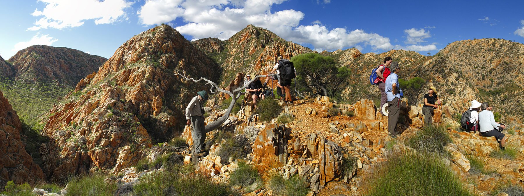
The mighty Larapinta – all 223km of it – is one of Australia’s most famous multi-day walks. It takes foot-borne explorers through a microcosm of the Northern Territory’s Red Centre landscape of rich-red rocky terrain, deep gorges with cool waterholes beneath, and ethereal ghost gums. It is a world-rated multiday trek that is a regular listing on any global trek hit list.

The Larapinta is nothing if not a versatile walk; there are a number of ways you can “do” the trek, including independently over 10-14 days (with one or two food drops along the way), you can join a guided group (still carrying all your food and gear), or you can take sample bites out of its 223km by tackling a shorter seven-day journey, via World Expeditions, or even a three-day luxury sampler, where you head out on day walks to the choicest highlights of the track, then are back in your swag (by a campfire complete with bush chef) by nightfall, just in time to admire the famous star-filled outback night skies.
The funny thing is, even allowing for its near-permanent appearance on every half-keen walker’s must-do list, the Larapinta Trail is far from crowded. This, of course, has a fair bit to do with its sheer size, as well as some people just not having the time to complete the full trek. So, what they do instead is bite off three- and four-day sections over the course of a couple of years to complete the walk.

You can walk the Larapinta in either direction: east to west, starting from Alice Springs’ historic Telegraph Station; or west to east, starting at the top of Mt Sonder, and making your way back into town. Either way, each day on the track brings with it a new and amazing highlight, whether it is the swimming hole at Ormiston Gorge, or the view across more rugged ridges of the West MacDonnell Ranges from the lookout above Standley Chasm.
Independent walkers will need to be fit (see our guide to being fit for adventures, here) – your pack will be full of food, tent, gear, clothing, etc. – and food drops will need to be properly organised through local operators in Alice Springs before you depart. The designated campsites all have water tanks and are, roughly, a day’s walk apart. The longest section is the 31km stretch from Hugh Gorge to Ellery Creek, but is flat going and, if you head off early, it’s a long-ish but not unbearable day.
There are numerous access points along the walk, with the track moving in and out of popular tourist spots along the way. Go guided and a lot of the planning is taken out of your hands. World Expeditions is the most experienced company when it comes to the Larapinta Trail, and it also offers a number of options, from the full-monty 223km, to a six-day experience and others. Whichever way you choose to walk the Larapinta, you will not be disappointed, but you will be amazed; this world-class walk is a great showcase for the Aussie outback. And you’ve gotta be proud of that…
FACT FILE
West MacDonnell NP and walk info: Parks & Wildlife NT
Guided walk options: World Expeditions
Thorsborne Trail, QLD
Hinchinbrook Island sits 8km off Queensland’s Cardwell coast (the small town of Cardwell is roughly midway between Cairns and Townsville) and is the physical embodiment of a Hollywood tropical island. Hinchinbrook is one of Australia’s largest island national parks – it covers 39.3sq.km – and it is on this wonderland that 40 hikers a day get to experience true tropical Queensland conditions when they tackle the four-day, 32km Thorsborne Trail.
This world-rated multi-day hike starts at Nina Bay in the north of the island, with walkers winding their way south to trail’s end at George Point. Over the course of the four days of moderate to challenging walking, following a rugged, rough track, you will move through everything from mountainous areas and long, deserted beaches, to eucalypt forest and lush tropical rainforest, with a number of pristine waterfalls along the way.
The trailhead is reached via a 40-minute boat trip from the coastal town of Cardwell, crossing the narrow Hinchinbrook Channel that separates island from the mainland. During this journey you will see an abundance of mangrove. This plant thrives here; the channel is claimed to be one of the largest mangrove habitats in the tropical north. Marine animals, such as dugongs and green sea turtles, are often seen here, with saltwater crocs also present.
Walkers can expect tropical forests, golden, sandy beaches, rocky headlands and bubbling creeks. The track itself is not graded and can be quite rough in parts so a good sense of balance, some multiday trek experience, and decent trekking fitness are essentials for optimum enjoyment. The depth of the waterways will depend on the season; a big Wet Season dump of rain can cause creeks to rise dramatically, with the potential of leaving you stranded for a day or more, unable to cross. It doesn’t hurt to allow for an extra day just in case, especially if walking the Thorsborne out of season.
As well as the main track, there are plenty of side-tracks, with the one-hour-return Nina Peak side-track worth the effort; you will nab great views of the island’s highest mountain – 1121m Mt Bowen – from this viewpoint.
The Thorsborne has seven campsites, with six of these near beaches. The standout is the campsite at Mulligan Falls, toward the track’s southern section, where you camp under the rainforest canopy right near the waterfall.
Peak walks time is April to September, owing to cooler conditions. You must also be self-sufficient, carrying all food/supplies/equipment, and even though there are creeks on the island, they can run dry, so take a minimum of 4L of water per person as a backup. Also pack water purification tablets (or a filter). It’s a great trek and, at four to five days, makes for brilliant hiking bang for your bucks in terms of time and scenic rewards.
FACT FILE
Track info and bookings: Queensland Parks & Forests
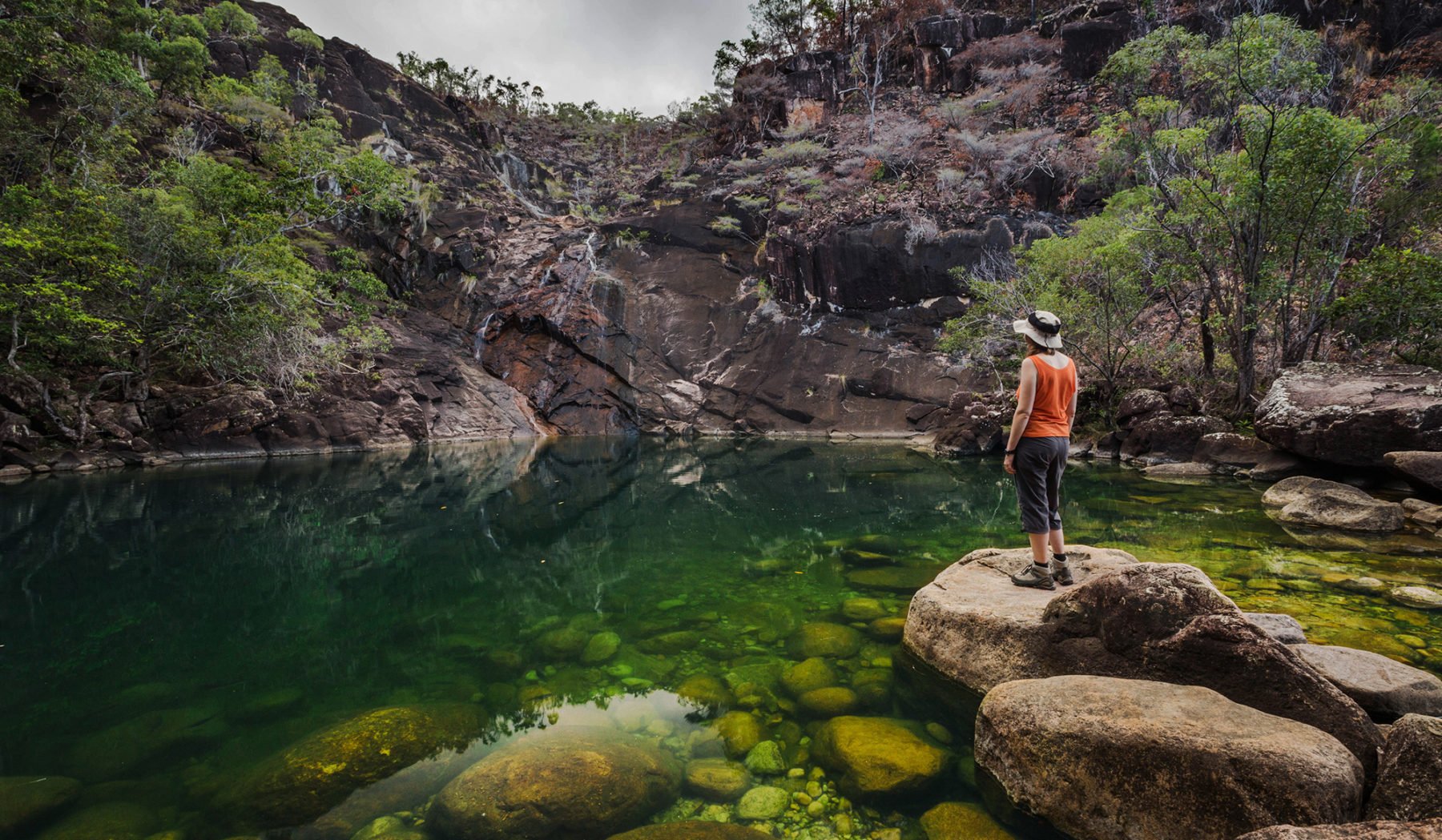
Jatbula Trail, NT
If the Larapinta Trail is the perfect NT Red Centre experience, then the 62km Jatbula Trail more than qualifies as its Top End equivalent; this multi-day walk is moderate in level but takes you through some of the most vibrant and engaging terrain in this country. It can be walked independently (you need to book well ahead for park camping/passes) or you can jump on board a guided adventure with tour operators such as World Expeditions.
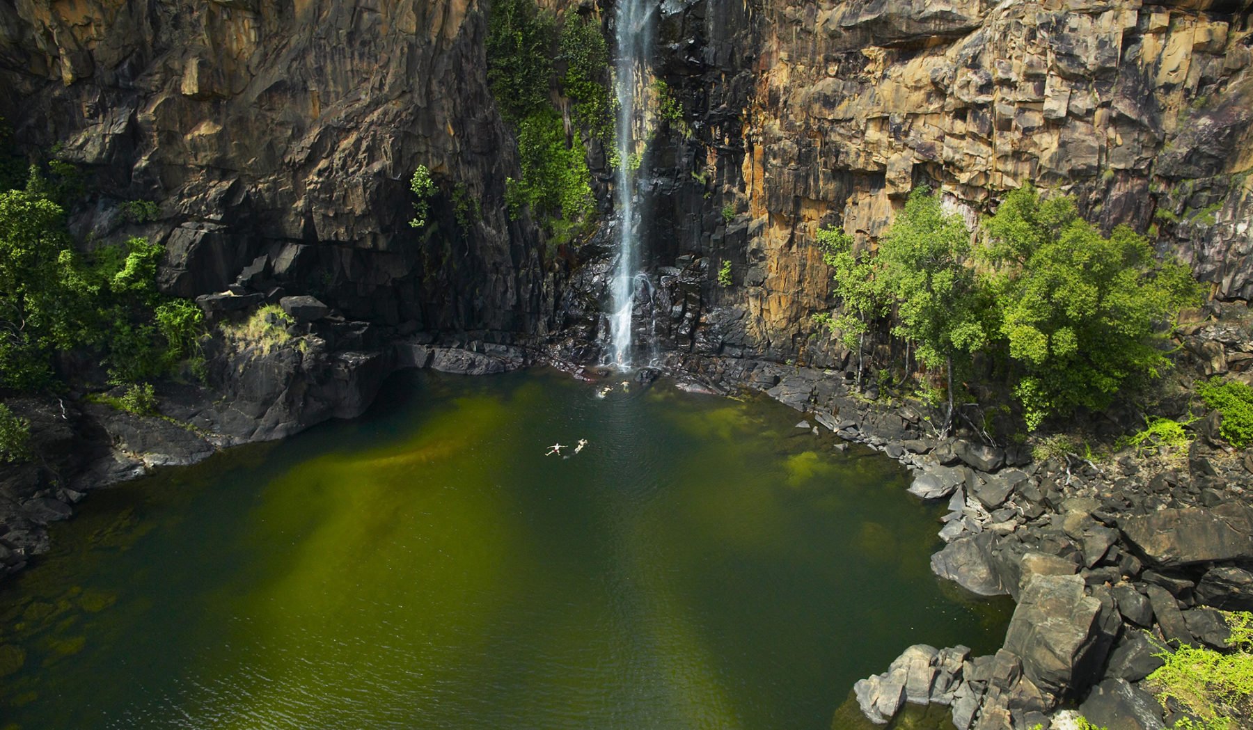
The Jatbula is located in Nitmiluk National Park and winds north (you can only walk it in this one direction) from Nitmiluk (Katherine Gorge – well worth a few days exploration itself) to Leliyn (Edith Falls). The route takes walkers on a tropical walking adventure along the western edges of the Arnhem Land Escarpment, experiencing savannah grasslands, rocky quartzite cliffs, creek-crossings, and exploring monsoon forests, with each day ending at the perfect campsite: right beside a cooling waterfall. This is Jawoyn country, and you’ll get the chance to spot brilliant rock art in a number of caves and rocky overhangs and outcrops as you trek an average of 10km each day (the longest stretch is 16km on Day 3, from 17 Mile Falls to Sandy Camp Pool) between campsites.
The first few days are spectacular as walkers traverse what is known as “stone country” before entering some pockets of monsoonal rainforest that are characteristic of the region. After a few days you’ll follow a gentler track as you walk beside the pretty Edith River to Sandy Camp Pool, where you’ll camp for the night, and then through paperbark forests and past more waterholes to Sweetwater Pool.
The hike is brilliant and can be done at a nice leisurely pace but start early each morning so you can take full advantage of the campsites’ locations right next to waterholes where you can swim and cool off during the afternoons. The trekking season is July to September up here, so as well as warm days and cool-ish nights, you should see plenty of stars in the clear NT skies.
In addition to the brilliant overall walking experience, the fantastic campsites and the rich indigenous history, the Jatbula’s start- and end-points are ideal if you’d like to spend more time here doing day walks through Nitmiluk National Park or canoeing up the gorge or down Katherine River. Or you can simply keep that waterfall spirit alive and spend a few days lolling about at Leliyn at the end of your tropical trekking adventure.
FACT FILE
Walk info and bookings: NT Parks & Wildlife
Guided options: World Expeditions