Earthquake map may predict future disasters
A NEW EARTHQUAKE HAZARD map could help to predict giant earthquakes more accurately, according to experts.
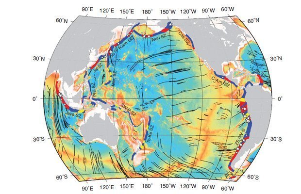
The map (above) is the result of new research that uses global data sets to identify the frequency of earthquakes in certain environments. According to researchers, it will help to prevent the surprise impact of large magnitude earthquakes such as Tohoku-Oki, which led to the 2011 tsunami in Japan.
Professor Dietmar Müller, lead researcher and geologist at the University of Sydney, says this new research would have been useful before the 2011 disaster.
“If we had done this piece of work a little earlier, then the very region where Tohoku-Oki happened would have been identified as particularly hazardous in the long term by our map,” Dietmar says.
Oceanic fractures, subduction and giant earthquakes
The scientists analysed regions of the earth where oceanic fracture zones met subduction zones – areas where two tectonic plates meet, and push one another towards the interior of the earth. The Pacific ‘Ring of Fire’, a high-activity region for earthquakes, is an example of a subduction zone.
To obtain the results, scientists used a statistical formula originally designed to track online consumer preferences. The results, published last week in the journal Solid Earth, showed that 87 per cent of the largest earthquakes over the last century were associated with areas where oceanic fracture zones met subduction zones.
“Our method simply reveals all those special tectonic environments where ocean fracture regions intersect with subduction zones,” says Dietmar. “The beauty of our map is that it picks up these regions, even though there might not have been an earthquake over the last few hundred years.”
Mapping earthquake hazard areas
Previously, almost all earthquake hazard maps relied on information collected after 1900, when the first modern seismometers were deployed. Given that the highest magnitude earthquakes occur very infrequently – often hundreds or even thousands of years apart – predictive approaches that do not rely on existing earthquake catalogues are invaluable.
“People are saying, ‘Why didn’t the current seismological models predict that Japanese earthquake?’” says paper co-author Dr Thomas Landgrebe, from the University of Sydney. “It’s probably got to do with the fact that giant earthquakes occur quite infrequently – that means you can’t rely on these old databases.
“Potentially having found the link between large scars on the ocean floor and giant earthquakes is a new and completely different method for identifying risky regions,” he says.
The project was the first of its kind to globally map these environments, and researchers are hopeful that other significant patterns will emerge due to innovative data analysis techniques.
“What has come out of our research is that linking global geo-physical data sets to earthquake hazard analysis is a really interesting future research area,” Thomas says.
RELATED STORIES

