Top 10 Australian mountains to climb
AUSTRALIA’S MOUNTAINS AREN’T the highest in the world, but some offer superb perspectives over our World Heritage-listed sites and other exquisite natural landscapes. And, thanks to their modest elevations, quite a few are day-walk endeavours.
Before lacing up your hiking boots, be aware that many Australian mountains are sacred to local Aboriginal people. Online bushwalking information for national parks such as Wollumbin-Mt Warning and St Mary Peak, for example, relay the traditional owners’ request that, out of respect, you consider not climbing.
For any mountains you do decide to summit, though, proceed with an attitude of appreciation and reverence – for the mountain spirits, the natural environment, your fellow bushwalkers, and, of course, the weather, which can change quickly.
Enjoy the views of these top Australian mountains to climb.

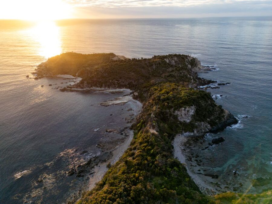
Mt Warning, NSW. (Image: Quentin Chester)
1. Wollumbin–Mt Warning, NSW
Dominating the lush Tweed Valley in New South Wales is Mt Warning. Its tilted summit curiously regards the famous surf breaks at Byron Bay well as hinterland towns such as joyful Uki. At 1156m, Wollumbin-Mt Warning in Wollumbin National Park attracts a year-round procession of boot-clad admirers. The mountain, a remnant central vent of an ancient volcano, receives Australia’s first rays of sunlight; to catch that early glow, some torch-wielding visitors begin the 9km, five-hour return hike in darkness. If you prefer starting and finishing in daylight, make sure to set out prior to 1pm in winter. Either way, mentally prepare yourself for the final section, which involves scrambling up a steep, rocky slope, using a chain for assistance.
Wollumbin National Park is part of the Gondwana Rainforests of Australia World Heritage Site. Camping isn’t allowed in the national park, but the peaceful Mt Warning Rainforest Park is only a few kilometres from the trailhead.

The view over Lord Howe Island from 857m Mt Gower. (Image: Jack Shick)
2. Mt Gower, NSW
World Heritage-listed Lord Howe Island has plenty of spots where you can seek complete solitude, but the 14km return track to the cloud forested summit plateau of 875m Mt Gower isn’t one of them. To capitalise on Gower’s lofty views of 777m Mt Lidgbird, castle-like islet Balls Pyramid, and much of the rest of this stunning 11km by 2km island and its marine park, you must go with a licensed guide. You’ll appreciate the company, though, particularly when you’re gripping the fixed safety ropes, trying to focus your attention on the ropes and the skinny, cliff-side ‘trail’ before you and not on the potentially unforgiving drop towards the Tasman.
Fifth generation islander Jack Shick of Sea to Summit Expeditions will help get you to the top. And if the idea of an 8.5-hour return walk doesn’t sound sufficiently exhausting, raise your hand when Jack asks for Kentia palm climbing volunteers.
3. Mt Kosciuszko, NSW
Impress your friends by saying you’ve climbed Australia’s highest mountain, 2228m Mt Kosciuszko, in Kosciuszko National Park. And if you begin from the top of Thredbo’s Kosciuszko Express chairlift, there’s no need to mention that your 13km return feat involved a mere 459m ascent. More impressive in terms of distance and elevation gain is the 21.5km Main Range circuit, which combines the park’s Main Range track and Summit walk. Start at Charlotte Pass and climb a total of 919m as you travel to alpine lake lookouts, Carruthers Peak, and the Kosciuszko summit before descending to Rawson Pass, historic Seaman’s Hut, and back to the trailhead. Whichever route you choose, the 360-degree views – plus the right to use a superlative – are well worth the effort.
The summit trail is likely to be covered in snow from May to October. Check conditions by contacting the Snowy Region Visitor Centre.
4. Mt Feathertop, Vic
Three access tracks lead to the summit of Victoria’s second-highest peak, 1922m Mt Feathertop; the most popular is the 11km one-way, mostly sheltered Bungalow Spur approach, which climbs 1400m from Harrietville. However, if you’d prefer a more modest climb and nearly constant high country views, opt for the 11km one-way Razorback track, which begins at Diamantina Hut and follows the craggy ridge from Mt Hotham through open snow grass and snow gum woodlands. Your destination is visible along much of the route, and the valleys to the west and rolling high plains to the east will give your mind plenty of room for wandering.
The Razorback Trail is straightforward, but alpine weather can change quickly. Carry a compass, map, warm/waterproof clothing, food, and mobile phone, communicate your plans before setting out, and be self-sufficient with water. For more information on the area, visit an Alpine Shire Visitor Information Centre.
5. Mt Barney, Qld
Southeast Queensland’s second-highest mountain, the ruggedly striking Mt Barney, in Mt Barney National Park, has several routes up its two granophyre peaks. However, they’re either unmarked or barely marked and require bushwalking experience and navigational skills. Avoid triggering a rescue effort by hiring a local guide, at least for your first ascent.
Mt Barney National Park is part of the Gondwana Rainforests of Australia World Heritage Site. In addition to leading you up the 1351m East Peak, enthusiastic Mt Barney Lodge Country Retreat co-owner Innes Larkin will point out mountain flora and present you with a steamy mug of local coffee at the top.
6. Walshs Pyramid, Qld
Part of a granite intrusion that underlies the Bellenden Ker Range in Queensland’s Wooroonooran National Park, 922m Walshs Pyramid is the focus of the annual Great Pyramid Race, where competitors run from nearby Gordonvale to the summit and back again. It’s difficult to appreciate their feat until you’re well into the steep and largely unshaded 6km return summit walk, and a certain broad rock delivers the cruel information that you’re only half-way. Keep going, though – the views over sugarcane fields, Gordonvale, and the surrounding hills are worth the effort.
After descending, drive up the Gillies Hwy to Lake Eacham, where you can lose all evidence of your sweat in the cool, blue waters.
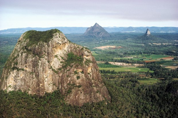
7. Mt Ngungun, Qld
The Glass House Mountains, a series of dramatic volcanic peaks, dominate the Sunshine Coast hinterland. And while some are too precarious for hiking, others invite footprints. Although its 2.2km return track is steep and gnarly in places, 253m Mount Ngungun’s summit gives visitors an intimate audience with spirelike 377m Coonowrin and pyramid-shaped 556m Mount Beerwah as well as a profile view of 364m Mount Tibrogargan’s gorilla-reminiscent countenance. Prior to ascending, read up on the mountains’ Aboriginal creation legend, and then spend some of your summit time pondering their sorry situation.
Hiking isn’t the only way to scale Mt Ngungun. Brisbane-based Pinnacle Sports runs half-day abseiling/climbing adventures here most Saturday mornings as well as full-day guided climbs upon request.
8. Cradle Mountain, Tas
Close to the starting point for the 65km Overland Track and forming the northern end of Cradle Mountain-Lake St Clair National Park, 1545m-Cradle Mountain is a magnificently jagged, dolerite peak in Tasmania’s northwest. To climb this oft cloud-shrouded mountain, set out from Dove Lake, following the eight-hour return main track via Lake Lilla and Marions lookout. You’ll ascend approximately 600m, scrambling across dolerite scree and columns to reach the summit and its 360-degree views into the World Heritage-listed Tasmanian Wilderness and beyond.
Pack clothing for cold and wet weather and check the forecast before beginning your climb. A Parks Pass is also required.
9. Bishop and Clerk, Tas
Named after its two dolerite peaks, which resemble a mitre-clad bishop followed by a clergyman, 630m Bishop and Clerk isn’t the highest mountain on wildlife-resplendent Maria (pronounced ma-rye-ah) Island, but it grants the most stunning views. After testing your agility on the 12km return trail’s final rock scramble, you’ll gaze out over the Tasman’s turquoise waters towards the Freycinet Peninsula, Schouten Island, and the Tasmanian mainland, spotting whales, perhaps, and also gulping nervously at the sheer drop-offs located mere steps from your perch.
You can visit Maria Island National Park on a day trip from Triabunna, but to make the most of your ferry fare, spend a few nights in the campground or in the circa-1830 penitentiary’s bunkrooms. A Parks Pass is required.
10. St Mary Peak, SA
The highest point in the sublime, sun-drenched Flinders Ranges, South Australia, 1171m-high St Mary Peak offers a 360-degree panorama of saw-toothed ranges, salt lakes, and the surrounding plains. The climb involves a taxing, 18km return walk, which begins from the Wilpena Pound Visitor Information Centre. The views from Tanderra Saddle, on the ridge of the peak and about 1.5km shy of the summit, are also superb. And by stopping here, you’ll be complying with the wishes of the area’s traditional owners, the Adnyamathanha.
Plan to walk in Flinders Ranges National Park between April and October, when temperatures are milder. Park entry fees for vehicles apply.
READ MORE: