The science behind Cyclone Debbie
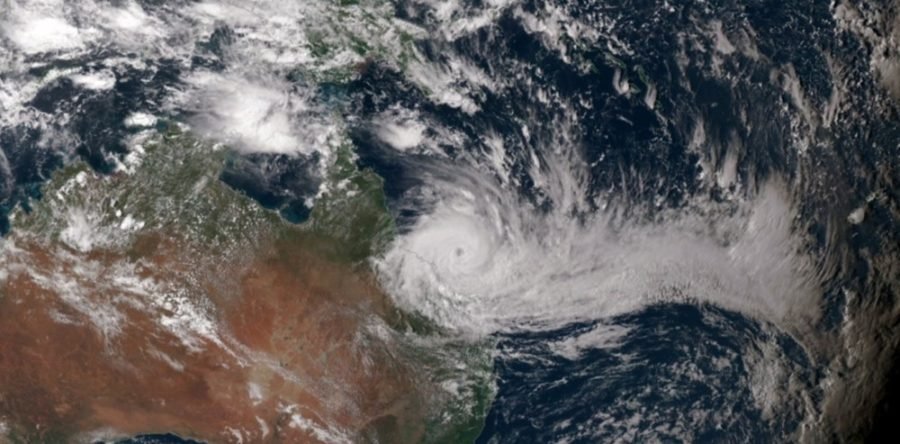
TROPICAL CYCLONE DEBBIE made landfall in Queensland as a category 4 cyclone yesterday with sustained winds of more than 150km/h. ![]()
The cyclone crossed the coast near Airlie Beach on Tuesday afternoon. Reports of wind gusts in excess of 200km/h and rainfall of more than 200mm of rain have been made in some areas along the central Queensland coast.
The Bureau of Meteorology forecasted an average to above-average number of Australian cyclones in its October severe weather outlook. Australia receives 11 cyclones on average each year, with about four of those in Queensland. Debbie is the fifth cyclone of the season for Australia as a whole and the most intense of the season so far.
Anomalously high moisture, warm ocean temperatures, and low environmental pressures seem to have created the conditions that allowed Debbie to form and grow in intensity.
RELATED: Australia’s most destructive cyclones in recent history
Perfect storm
Tropical cyclones are low pressure systems that form over warm tropical oceans. The warmth and moisture of the oceans are what gives a cyclone its energy. The low pressure, which meteorologists measure in “hectopascals”, draws in the surrounding warm, moist air, which then rises into deep thunderstorm clouds. As the air is pulled into the centre of low pressure, Earth’s rotation causes it to spin cyclonically and it continues to intensify.
Debbie formed at the eastern end of an active monsoon trough extending from the Indian Ocean across the top of Australia and into the Coral Sea. The monsoon trough is a region of low air pressure and thunderstorms that forms over northern Australia in the summer months, bringing with it the wet season. On 22 March, a large region of active thunderstorms began to organise into a weather disturbance off the eastern tip of Papua New Guinea.
Over the following two days the thunderstorms organised about a circulation centre as sea level pressures began to drop and moist air converged into the area. By late on 24 March a tropical depression, a forerunner of a cyclone, had formed and begun to drift south, making a long S-shaped track.
Tropical Cyclone Debbie was named on 25 March. It then came under the influence of the subtropical ridge, a zone of stable high pressure that gives much of Australia’s fine weather during the summer. This drove Debbie west-southwest towards the Queensland coast while it gradually intensified further.
Because of the relatively high amounts of moisture in the atmosphere, and relatively warm ocean waters, Debbie intensified to category 4 by 10pm on 27 March, with the strongest wind gusts reaching 225-280km/h. On Tuesday afternoon Debbie was a strong category 4 cyclone with a central pressure of 943 hectopascals and surface sustained winds of 185km/h. The Bureau of Meteorology downgraded Debbie to a category 3 at 4pm EST.
To put Debbie in context, there has been only one cyclone since 1980 to have made landfall in Queensland with a lower central pressure. That was Yasi in 2011.
Of the 46 cyclones to have made landfall in Queensland since 1980, only three others arrived at the coast with pressures of less than 960 hectopascals: Dominic in 1982, Winifred in 1986, and Ingrid in 2005.
RELATED: How do cyclones form and what do the categories mean?
Predicting cyclones
Tropical cyclone forecasters use a variety of tools to forecast the storm’s track, intensity, storm surge, and rainfall. Because it is difficult to obtain observations of wind at the ocean’s surface under a cyclone, meteorologists have developed tools based on satellite imagery to estimate a storm’s intensity, location, and where the strongest and most destructive winds are found.
Several models are also used to aid in making forecasts – from the complex numerical weather prediction models, to statistical models. Models start by using observations of the atmosphere, and then use these data to make a forecast.
Depending on their level of complexity the models can predict the future track, intensity, rainfall, wave height, and/or storm surge. The forecasters access all of this information to then make their forecast.
Cyclone forecasts have improved considerably over time. In particular, track forecasts have improved so that the 48-hour forecast is now more accurate than the 24-hour ones were back in the early 1990s. Track forecasting has become so reliable that the US National Hurricane Centre now produces 120-hour track forecasts.
Intensity forecasts have improved more slowly, but as models have become more refined and satellite technology has improved, the ability of forecasters to accurately estimate and predict intensity is also getting gradually better.
The prediction of rainfall, the extent of the damaging wind field, and storm surge forecasts are also slowly improving. Now that they are receiving more attention, we can expect considerable improvements in these over the next decade.
Liz Ritchie-Tyo, Associate Professor, School of Physical, Environmental, and Mathematical Sciences, UNSW.
This article was originally published on The Conversation. Read the original article.
READ MORE: The biggest cyclones in recorded history