Walking and sailing the east coast of Tasmania

THE SUN PIERCING the eastern horizon shot fingers of light across the water and into the broad gap that leads to Wineglass Bay. The rays inflamed the orange lichen-covered boulders that lined the shore and then chased up the pink granite flanks of The Hazards, imbuing them with a rosy glow before bathing that famed arc of white in a subtle shade of lilac.
I was up early and watched this lightshow from the deck of Lady Eugenie, an elegant teak-and-fibreglass, 75ft (22.8m) ketch moored in the bay, and the only vessel there on that perfect autumn morning. Apart from the sound of water lapping the hull, the scene was silent and still, the abundant birdlife yet to stir. Fresh footprints on the beach betrayed the presence of a pair of Tassie devils. It was Wineglass Bay as few get to see it.
Within a couple of hours the first flurry of day-trippers would start to file onto the beach – often named among the top 10 in the world and one of Tasmania’s biggest tourist drawcards. But most visitors don’t make it that far. The Wineglass Bay Lookout, a 45-minute climb from the car park, is as far as the majority get.

The party from Lady Eugenie heads north along Wineglass Bay. A walk to a lookout takes an hour and leads you up a well-formed rocky track. (Image: Chrissie Goldrick)
For those who do make it on the three-hour undulating round trip to the beach, it’s close to a full day’s outing. The prospect of carrying in all your gear reduces the numbers intent on staying overnight in the campsite there even further, but the intrepid few get to enjoy the bay at its quietest, and bathed in all its morning glory.
A BOAT STAY offers another way to experience the magic of waking up in Wineglass Bay. I was there aboard Lady Eugenie with six other passengers and four crew; we were on a Tasmanian Walking Company four-day bushwalking expedition across Maria and Schouten islands, and the southern end of Freycinet Peninsula. We stayed on the yacht at night and enjoyed guided treks by day – which enabled us to enjoy the best bushwalks in the area over the course of just a long weekend.
Our adventure had begun three days earlier on Maria Island after a crossing from Orford on the mainland. You can also catch a daily ferry to the island’s main settlement, Darlington, from Triabunna. A quick shuttle in Lady Eugenie’s dinghy across clear, emerald waters to Darlington’s jetty and we were ready to explore this jewel in the Tasman Sea.
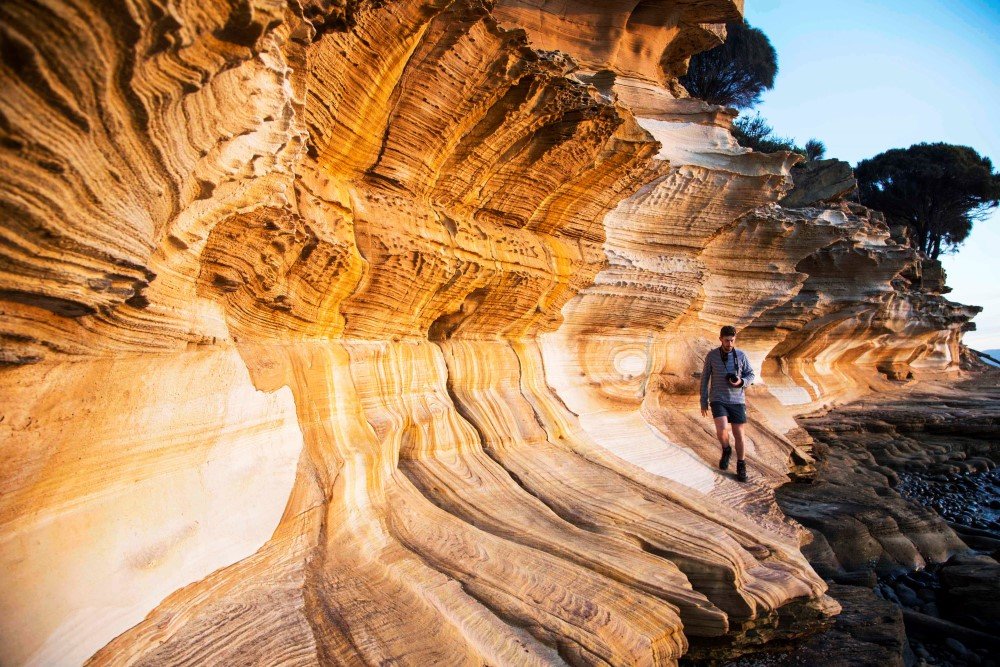
The patterns in the Triassic sandstones of Maria Island’s painted cliffs are traces of iron oxide caused by groundwater leaching through the stone. (Image: Chrissie Goldrick)
We only had an afternoon, so we were keen to cover as much of the 19 x 13km island that we could. We passed some very excited children riding about on bikes and a few resident Cape Barren geese grazing on the grasslands that lead down to the Fossil Cliffs (it was here that 19th-century Maria Island entrepreneur Diego Bernacchi excavated marine fossils from the limestone cliffs to make lime for his cement works, the four concrete silos of which still dominate the Darlington skyline).
We climbed back up a track onto a line of spectacular cliffs that led to the 620m dolerite peak, Bishop and Clerk, but – short of time – we detoured inland past skittish mobs of forester kangaroos and entered dense woodland where we found more remnants of Bernacchi’s enterprise: a ruined brickworks and the convict-built reservoir that still supplies drinking water to the Darlington settlement. I almost trod on a copperhead snake sunning itself on the track and spotted one of the common wombats that appeared in ever greater numbers as the day started to cool.
The pace quickened as we aimed to reach Maria’s famous painted sandstone cliffs before the sun disappeared and along with it a must-have photo opportunity. We found a shortcut through a cluster of attractive penitentiary buildings that once housed convicts, but today provide affordable bunkhouse accommodation for visitors. Here was a lively crowd of young families enjoying a weekend getaway at this idyllic spot.
Snapshots done, we rejoined Lady Eugenie, now anchored offshore from the cliffs, her two masts silhouetted sharply against a reddening sky.
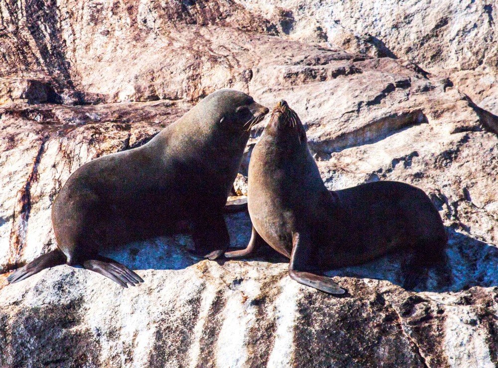
Isle des Phoques (Island of seals) once had a sealing station. Today it’s a nature reserve and haven for these Australian fur seals.(Image: Chrissie Goldrick)
CAPTAIN IAN SAUNDERS was up early the next morning to get us underway for the four-hour voyage to Schouten Island. Along the way he skilfully manoeuvred the ketch in close to a 7ha nature reserve, Ile des Phoques, home to a large and boisterous Australian fur seal colony, whose curious members slid and careered into the churning waters for a closer look at us.
A pair of sea eagles observed our departure from a 50m granite spire, while a large pod of common dolphins rode the bow as we sped away towards Schouten and our next walk. My wildlife tick list was growing longer by the minute.
Like Maria Island, Schouten has seen its share of commercial ventures – from whaling and sheep farming to coal extraction and tin mining – but it was formally added to Freycinet National Park in 1977 and is an important nesting site for little penguins and short-tailed shearwaters. The 3440ha island can be reached from Coles Bay, 30 minutes away, by boat charter.
On our visit we climbed 299m Bear Hill, the lower of three peaks. It looked a little daunting from the beach – it’s a vigorous 90-minute scramble and rock-hop up a succession of large, polished, pink-granite boulders – but the trusty grip of my Vibram soles, and the advice and encouragement of our knowledgeable guides Erik Hayward and Hania Watt, saw me reach the summit.
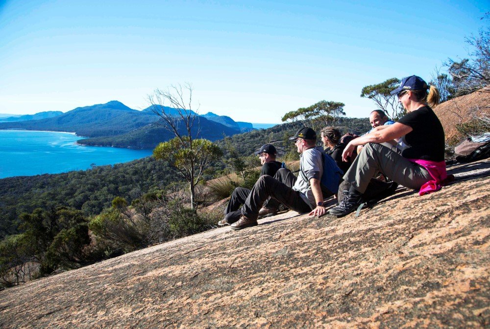
The walkers enjoy a rest and a view of Freycinet Peninsula from a smooth pink granite boulder during the ascent of Bear Hill on Schouten Island. (Image: Chrissie Goldrick)
Freycinet Peninsula stretched away to the east and north of this commanding vantage point in ever paler shades of blue-grey and Erik pointed out the distinctive outline of The Hazards to the north, which would be the next day’s bushwalking goal. Our island-hopping days were over as, on the third morning, our skipper piloted us towards Freycinet Peninsula’s southern tip. We landed on pretty Cooks Beach on the western shore of the peninsula, ready to tackle the biggest walking day of the trip. At the northern end of the beach, we climbed up into the welcome shade of the heathland plateau and followed the Peninsula Track through stands of Tasmanian blue gum, coastal she-oak and Banksia marginata. Here the sound of lapping waves gradually faded, replaced by the rhythm of our muffled footfalls accompanied by a seemingly infinite variety of birdsong, among which the endangered swift parrot can be heard.
The track eventually delivered us onto Hazards Beach.
Evidence of Aboriginal occupation is woven into the topography of the coastal landscape here; it is visible in layer upon layer of shell middens, laid down over millennia of feasting by the Toorernomairremener people on the marine bounty of appropriately named Promise Bay. The middens underpin the sand cliffs that run along the entire 2km beach. It’s also a breeding site for small red-capped plovers, which busily scurried about on the sand, and we were warned to keep a sharp eye out for their vulnerable little nest scrapes as we tramped on in the direction of the Hazards, which loomed large ahead.
We turned inland once more and followed the Isthmus Track towards Wineglass Bay. From here walkers increased as we were joined by those tackling the Hazards Beach Circuit Track, one of the day walks that started at the Wineglass Bay car park, and we wistfully relinquished the relative solitude of past days. The track led past Hazards Lagoon and onto our final destination. It was late afternoon and excitement mounted as glimpses of shimmering white quartzite sand started to appear through the
vegetation and we descended towards the famous bay.
This perfect curve of quartzite beach, gently lapped by impossibly clear water, didn’t disappoint. Walking boots were quickly discarded and hot, tired feet plunged into soothing water. Lady Eugenie was anchored in a cove at the far end of the beach. It took us about an hour to reach her as we dawdled along, posing for photos and revelling in the end of the day’s exertions and the prospect of spending our final evening aboard in this iconic place.
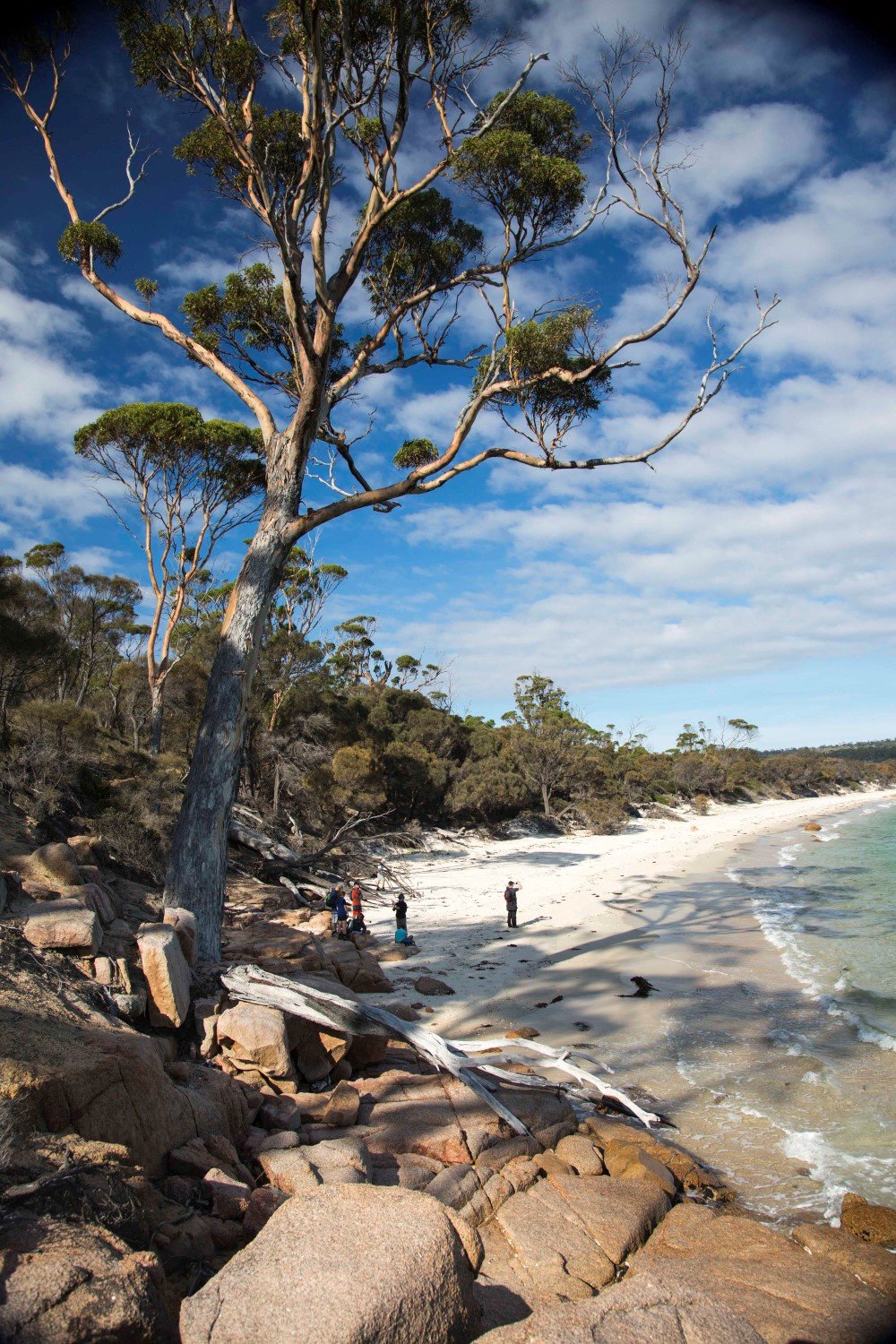
Maria Island is one of the best places in Australia to observe wombats. Cooks Beach (far right) at the southern end of the Freycinet Peninsula. (Image: Chrissie Goldrick)
ON THE LAST MORNING we disembarked onto the beach and headed up the track that takes us over The Hazards saddle, down to the car park and finally on to Hobart and home. After three days of brisk walking, we made light work of the steep path. It was a short detour to the busy Wineglass Bay Lookout from where I spied the graceful form of Lady Eugenie heading south, dwarfed by distance and a series of high cliffs.
This classic view of the horseshoe of pure white sand usually provides the first encounter with Wineglass Bay. For me it was my last look, and as I jostled for position at the steel barrier, brandishing my camera, I knew I was privileged to have enjoyed a deeper connection with this special place that my happy snap couldn’t possibly hope to capture.
Australian Geographic would like to thank The Tasmanian Walking Company, Tourism Tasmania and Tasmanian Parks and Wildlife for their assistance with this article.
This article was originally published in the Jan-Feb 2017 issue of Australian Geographic (AG#136).
READ MORE:
- Traversing Tasmania’s Western Arthurs
- Paddling southwest Tasmania
- 6 of the best Tasmanian adventures


