The best multi-day walks in Australasia


Western Arthurs Traverse, Tasmania
Distance: 75km (8-12 days)
Spoken about in hushed, reverential tones by hard-core Aussie bushwalkers, the Western Arthurs Traverse is an epic that more than holds its own on the global top trek scale and a no-brainer for inclusion on any serious adventure bucket-list.
The mix of unforgiving, unpredictable weather (the trek is situated deep in Tassie’s wild southwest) that can (quickly) hit any time of year – combined with the crazy-tough terrain (steep, slippery muddy tracks, time-sapping scree fields, scramble-only rock sections, and dense Australian vegetation) make this eight-to-12-day circuit (over 75km) one for the super-experienced trekker.
For all that effort – even getting to the start point is a challenge due to its remoteness – this wild adventure offers one of the world’s last remaining true wilderness experiences.
Owing to both the overall difficulty and its end-of-the-earth location, the Western Arthurs Traverse is only attempted by a small number of independent walkers each season.
You will definitely find that lusted-for sense of isolation, and be rewarded (on clear days) with views of some of Australia’s most rugged country – especially once you get up high on the ridges and peaks and can see way, way down to the many lakes in the immediate area.
To attempt the Traverse, you must be fully prepared, very fit (able to carry a pack of at least 30kg) and experienced at remote-area trekking. Expect every type of challenge you can think of – weather, terrain, fitness – and prepare accordingly.
It sounds grim, but it’s not. Build up to this adventure with some of Tassie’s other treks – the South Coast Track; Port Davey Track; Walls of Jerusalem Circuit – and then set your sights on this big bopper. The Western Arthurs Traverse crosses one of the world’s last remaining wilderness areas, and if you’re prepared, experiencing it on foot will firmly qualify this trek as the trip of a lifetime.
More info: www.park.tas.gov.au
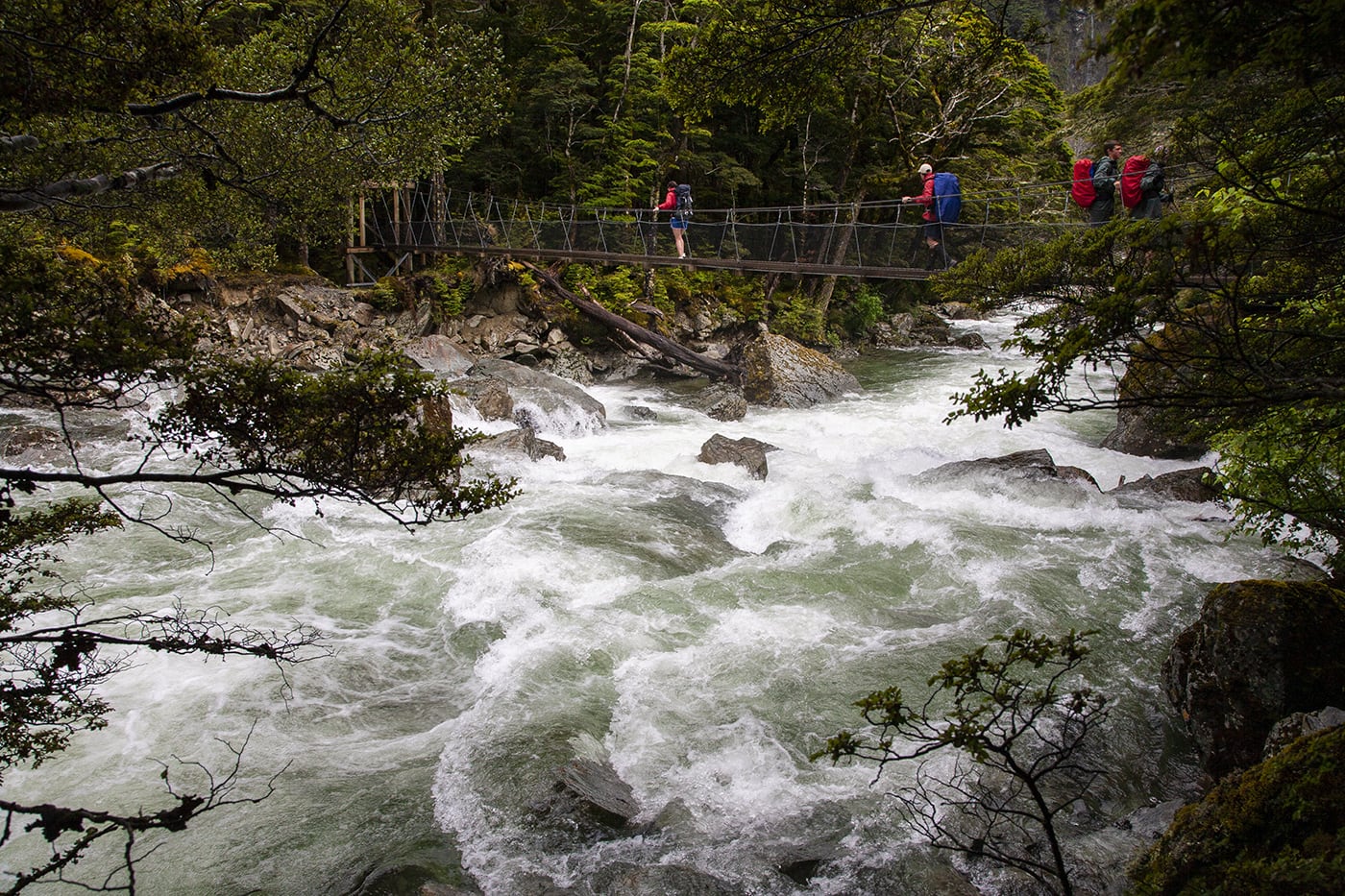
Routeburn Track, New Zealand
Distance: 32km (3-4 days)
Yes, the well-known Milford Track is right next door, but for those looking to jam in the most of NZ’s Southern Alps landscape – mountains, fast-flowing alpine rivers or beautiful beech forests of multiple shades of green – then the Routeburn Track is the best of the nine NZ Great Walk.
The Routeburn can be walked in either direction: from Routeburn Road end, in the east, to The Divide or vice-verse. Either way, you’ll be gobsmacked by the landscape within minutes of hitting the track. At 32km, you could even, theoretically, complete the Routeburn Track in two days, but that would be a disservice to the track and yourself.
Our preference would be to start from the eastern point at Routeburn Road and get the big climb up to Routeburn Falls Hut out of the way on day one. The Falls Hut is probably one of the most dramatically situated of NZ’s Department of Conservation (DOC) backcountry huts, perched high overlooking the river valley (and Mt Somnus) below, with a waterfall running down one side of its location.
The second day on the Routeburn is spectacular: you continue climbing to Harris Saddle (and Lake Harris along the way), before winding your way along the (near) top of the Serpentine Range, with views of the Hollyford River valley, before descending to Lake Mackenzie Hut, another beautifully located hut.
The final day involves an initial climb, passing Routeburn Falls on the way, before descending to Howden Hut and then climbing up again to The Divide. One side track not to miss is the one to The Divide. The turnoff is 15 minutes from Howden Hut and when you arrive at The Divide (1.5-hr return walk) you get awesome views of the Darran Mountains.
The track is well graded throughout with only a few short rocky sections, and the Great Walks huts (for independent walkers) are brilliant (gas stoves and wood heating, plus bunk rooms).
As long as you’re well prepared for the region’s oft-changing weather (and remember to book your hut tickets well in advance; Great Walks booking season opens July 1), the Routeburn Track is perfect for those just getting started on multi-day treks, and adventurous families; children from 10 years of age upwards easily handle this walk.
If there’s one world-class track we’d recommend for introduce the family to the joys of multi-day trekking, it’s the Routeburn.
More info: www.doc.govt.nz/parks-and-recreation/tracks-and-walks/great-walks/
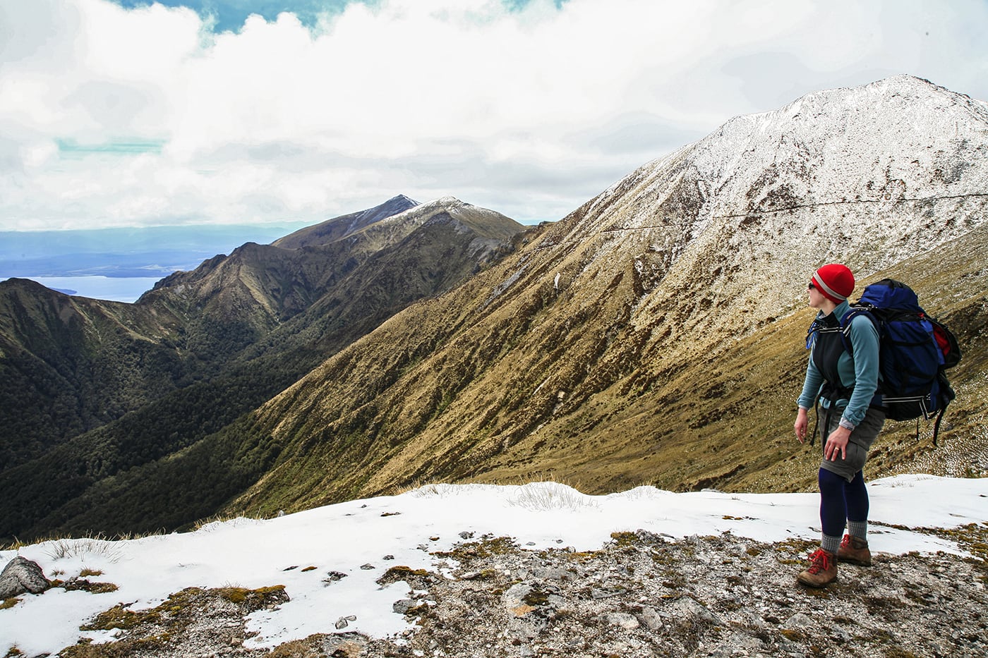
Kepler Track, New Zealand
Distance: 60km (3-4 days)
Built to take some of the “tramper load” off the nearby Milford and Routeburn tracks, the 60km (three- to four-days) Kepler, in NZ’s Fiordland National Park, has become a sought-after trek in its own right.
Dense forests, alpine vegetation, exposed mountain ridges and steep climbs and descents make it very popular. Its other appeal is you can start directly from the township of Te Anau, as it circuits back there at the end.
The Kepler can be walked in either direction, starting at Lake Te Anau Control Gates or, if you wish to walk clockwise, from Rainbow Reach (accessed via shuttle). Most walkers will complete the Kepler in three days, staying at two of the three huts (or two camp sites) on the track.
Starting at Rainbow Reach, the first day can be either a flat, two-hour stroll through beech forest to Moturau Hut, on the shores of Lake Manapouri, or a 22km journey to Iris Burn Hut. If you stay at Iris Burn Hut, there’s a chance you may – if lucky – hear kiwis at night in the surrounding valley.
From Iris Burn Hut, it is a steep, zigzagging climb of about 890m up through sub-alpine forest to Hanging Valley Emergency Shelter (1390m) on the exposed – but breathtaking – ridge line.
This is a great spot for an early lunch – and for also spotting NZ’s cheeky alpine parrot, the kea. In adverse conditions (it can snow here any time of year), this exposed section can be dangerous, but the two emergency shelters (Hanging Valley and Forest Burn) provide protection. The track follows the ridge line from here, to Luxmore Hut (overlooking Lake Te Anau), via the side trip to 1472m Mt Luxmore if the weather is clear.
The final day from Luxmore Hut is a descent through mixed vegetation – and past a massive, 200m-long, 60m-high limestone “wave” rock formation – to either Brod Bay, for a water-taxi trip across Lake Te Anau, or around to the Control Gates and on to Te Anau itself.
More info: www.doc.govt.nz/parks-and-recreation/tracks-and-walks/great-walks/
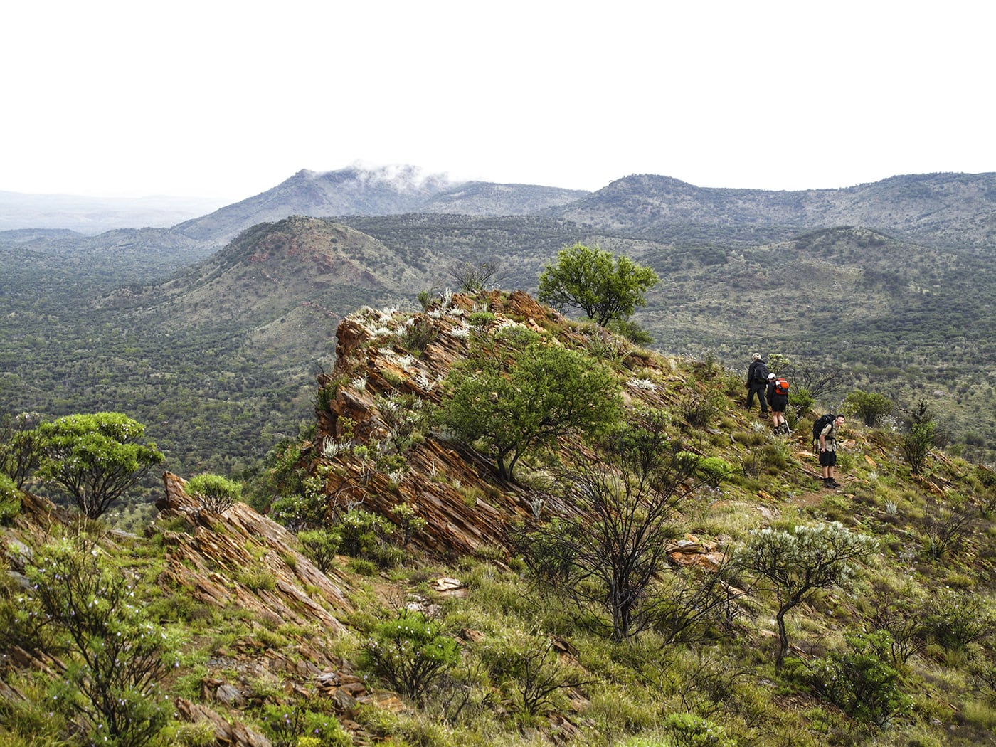
Larapinta Trail, Northern Territory
Distance: 223km (10-14 days)
The Larapinta’s 223km (allow 10-14 days) encapsulates all that is spectacular about Central Australia: massive star-crowded nights, ancient red rock ridges and cliffs, beautiful gorges (and waterholes), myriad dry creeks, a surprising number of waterholes, and sublime sunrises and sunsets.
For any trekker – whether Australian or from overseas – the Larapinta represents one of the best methods of experiencing the true Australian outback, at your own pace.
You can walk the Larapinta east-west or west-east, following the track as it winds its way through the West MacDonnell Ranges, just west of Alice Springs.
For those starting from the east, you set off from the historic Old Telegraph Station and set your sights to the west and the end-goal of summiting Mount Sonder for the last morning’s sunrise.
Each day on the Larapinta throws up a different spectacle, ranging from the view atop the ridges surrounding Ormiston Gorge, and a relaxing swim in the cooling waters of Ellery Creek Big Hole, through to the sunrise from Mount Sonder and the random wildlife encounters throughout the trek.
The Larapinta crosses two parallel mountain ranges: the Heavitree and the Chewings and the myriad gorges, valleys and waterholes these ranges contain. Three standouts are Simpsons Gap, Standley Chasm and Glen Helen.
For independent walkers, you will need to be fit and strong (you’ll be lugging a full pack of around 15-25kg) and have to organise a food drop or two.
There are designated campsites (with water tanks) on the Larapinta (these are spaced roughly a day’s walk apart, although one section – Hugh Gorge to Ellery Creek is, at 31km, quite long but relatively flat going), as well as a number of access points along the way for both food drops or if you decide to walk only a few sections of the track.
For guided walkers, World Expeditions offers three-day and seven-day Larapinta experiences, as well as the full-length Larapinta Trail, and all you have to worry about is being fit enough and enthusiastic.
The best time of year is the Australian autumn and winter (April to September) and the amount of time you dedicate this fantastic trek is up to you. What we can say is that, once you set your first foot on the Larapinta, you will want to stay on the track for as long as possible, to soak up this awesome experience.
More info: www.parksandwildlife.nt.gov.au www.worldexpeditions.com.au
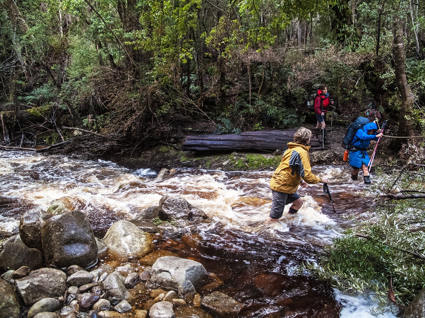
South Coast Track, Tasmania
Distance: 85km (6-8 days)
A truly remote experience – and one of Australia’s best multi-day walks. Access is via plane, landing at Melaleuca, and then it is six-to-eight days – and 85km – in the southern wilderness as you follow the South Coast Track from Melaleuca through some of southwest Tassie’s spectacular terrain, to Cockle Creek, and what will be the best burger and chips you’ll ever eat.
The weather this far south is volatile – you will need to be fully prepared for all conditions, with a mix of cold-weather and hot-weather gear, plus a robust three-season tent and warm sleeping bag.
This writer walked the SCT in February and experienced everything from wild storms and 6-degree Celsius daytime temps, to warm, sunny days. The track is (in)famous for its muddy sections, some of which will see unwary walkers sink to near-waist level, so be prepared for wet, muddy gear.
The first few days offer a brilliant introduction; walkers experience everything from deserted beaches, thick rainforest, river crossings (and a boat crossing at New River Lagoon) and sublime campsites.
Then, midway through the SCT, it is the big one: the traverse of the rugged Ironbound Range, a full day climbing from sea level, up to over 1000m, and then back down to the beautiful Deadmans Bay campsite overlooking the Southern Ocean (a perfect base for an optional rest day).
The descent to the bay is tough on the knees and can be very slippery, so take your time. This day will test your trekking fitness but reward you with either amazing vistas (on a clear day) or a memorably wild buffeting from wind or rain up on the exposed top if the weather is not cooperating. Either way, it is a memorable experience. And the South Cape Range (around half as high as the Ironbounds), later in the trek, is nearly as much fun.
The SCT has earned its reputation as a top trek for a very good reason: it is simply brilliant.
More info: www.parks.tas.gov.au


