Rees-Dart Track, NZ

ROSS IS A prominent lawyer from Melbourne and has an unfulfilled dream: once in his lifetime he would like to stand on the Cascade Saddle and enjoy the dramatic view into the wild world of glaciers around the 3033m Mt Aspiring, New Zealand’s version of the Matterhorn.
He tried the year before, climbing up to the saddle on the murderously steep track from Aspiring Hut, but he didn’t make it. Now time is running out for him. In his mid 50s and a victim of long, boozy lunches, he wants to try one more time to conquer the alpine wonder world of Mt Aspiring National Park in New Zealand’s Southern Alps. This time he sets his hopes on the Rees-Dart Track. It is the longer but easier way to reach the Cascade Saddle.
We meet Ross at the carpark at the start of the trek and walk together. Not even two hours into the Rees-Dart Track, still in the lower reaches of the long Rees Valley, disaster strikes. He misses a deep hole in the overgrown path above the Rees River and stumbles. Propelled by his heavy trekking pack, he tumbles down the steep banks and hurts his ankle so severely that he has to abandon his second attempt to reach the elusive saddle before it even started in earnest. His dream shattered, we promise the disappointed man we’d climb the saddle for him and report back on our return to Australia.
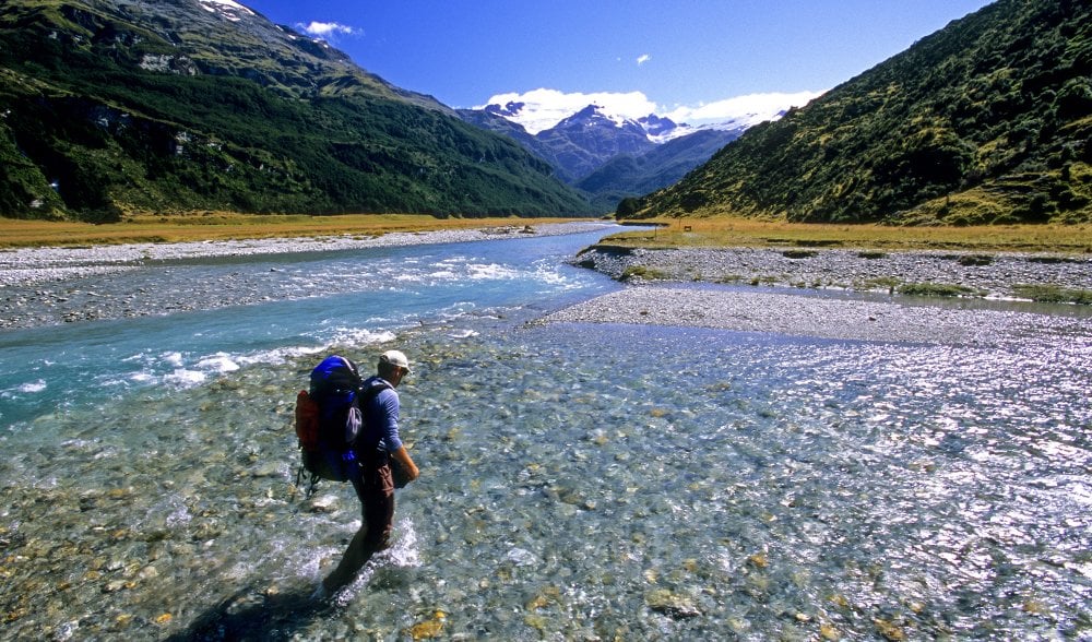
With rivers running glacial-blue, and mountains all around, few would argue the immense appeal of the Rees-Dart. (Image: Don Fuchs)
A path less travelled
The Cascade Saddle is considered the highlight along the five-day long Rees-Dart Track and many trekkers plan an extra day for this side trip from the Dart Hut. The Rees-Dart Track itself circumnavigates the glaciated Mt Earnslaw (2830m) and the wild and jagged peaks of the Forbes Mountains.
The long valleys of the Rees and Dart rivers form the stage for most of the trek and while the Rees-Dart Track is one of the lesser known multi-day walks in the Southern Alps, it is considered slightly more demanding than others. Compared to the Great Walks, the infrastructure of the Rees-Dart Track is comparably minimalist. Most of the time trekkers follow just a small and in sections rough path. Markers are limited and the three huts along the track, although comfortable, don’t have the luxury of installed gas cookers like the huts along the Great Walks.
Only the major creeks and rivers have bridges. During times of heavy rain trekkers can easily get stuck along the Rees-Dart Track. Then the numerous creeks that tumble down the steep slopes of the valleys can turn into raging torrents in a very short time making it impossible to continue.
The strict permit system of the Great Walks, which regulates your stay in the huts there, doesn’t apply to the Rees-Dart Track; you don’t have a guaranteed bed every night along this track.
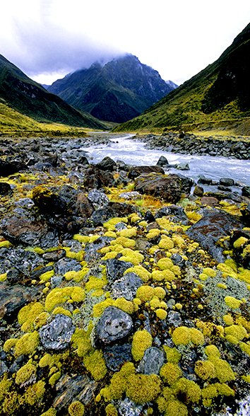
Moss-covered rocks in the Upper Dart Valley. (Image: Don Fuchs)
History lesson
Long before Europeans arrived, the Maori were familiar with the long valleys of the Rees and Dart rivers. They followed them in search of the sought after and precious pounamu (jade) deep into the mountains of the Southern Alps. Even from the wild and isolated west coast, climbing over high mountain passes, Maori reached the Dart Valley to collect the valuable stone that was used to manufacture weapons and jewellery. The Europeans who penetrated these valleys later weren’t after pounamu; they were lured by the prospect of gold and to establish grazing grounds for their sheep. The first sheep paddocks in both valleys were cleared in the 1870s.
The trek
Today the sheep are gone and cattle roam the lower meadows of the river valleys, with glaciers and dramatic peaks towering above them. This is the picture we saw on our first day on the Rees-Dart Track. The overgrown path leads through meadows into the U-shaped Rees Valley, a valley carved by glaciers. The glittering band of the Rees River winds through extensive gravel flats. Several hours into the valley, the alpine meadows are abruptly replaced by dark beech forests. We have reached the border of Mt Aspiring National Park.
With the crossing of the roaring Rees River over a typical-for-New Zealand swinging bridge, the climb to the first hut, Shelter Rock Hut, begins in earnest. The small hut is situated on the upper limits of the beech forest, sheltered by an enormous rock. Above the hut, craggy mountains reach to the sky. Avalanche gullies still packed with dirty snow and narrow tongues of scree reach down to the valley floor. The surrounding mountains are composed of metamorphic rock, sediments altered by enormous heat and pressure. This friable rock is the reason for the craggy, sharp appearance of the mountains here.
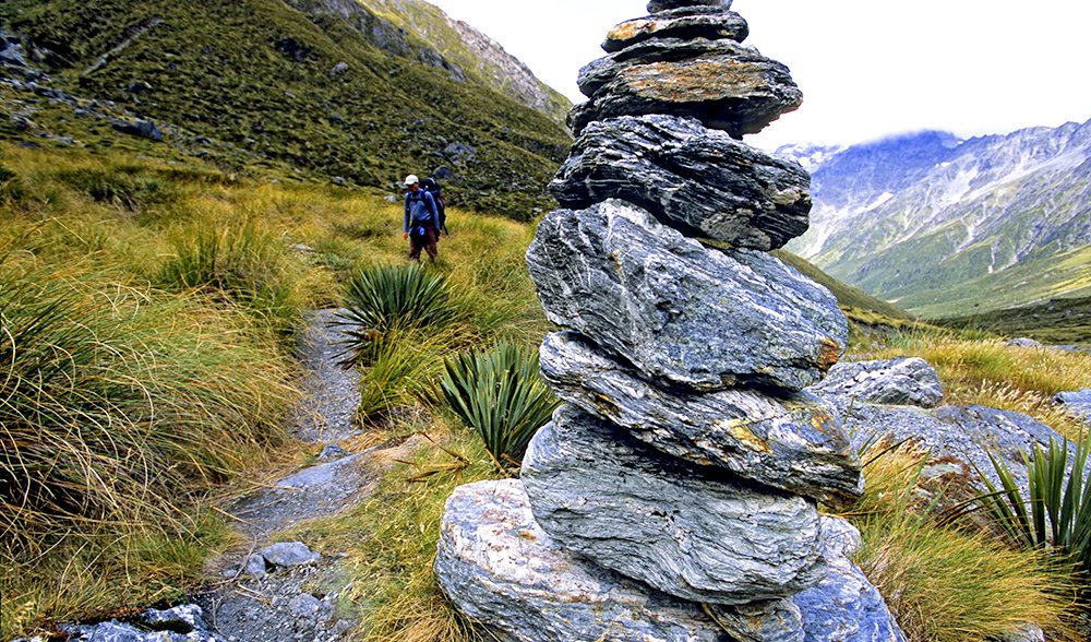
Stone cairn in the Upper Rees Valley. (Image: Don Fuchs)
After Shelter Rock Hut the landscape changes. The final ascent to the 1471m Rees Saddle begins. Trekkers now walk in a landscape above the tree line shaped by glaciers. Tussock and spear grass with its needle-sharp tips dominate the vegetation. In spring and early summer mountain buttercups and daisies transform the meadows here. This part of the track on day two is dominated by tremendous views back towards the glaciated pyramid of Mt Earnslaw. From the valley head a steep grassy slope finally leads up to Rees Saddle. Once up there the view north to Humboldt Tower opens up. Behind it, the heavily glaciated Snowdrift Range is visible.
The drawn-out descent to the Dart Hut leads through the narrow valley of Snowy Creek. Grass dominates the vegetation; a few tarns create nuggets of beauty in a harsh alpine landscape. After crossing Snowy Creek, which plunges not far from here into the Dart Valley, we are tested by the last climb before the final descent to the hut.
The descent is steep and exhausting; Dart Hut sits close to the tree line and is sheltered by a stand of beech trees above the roaring Dart River. Below the hut, the waters of the river get thrown against large boulders. A layer of fine mist hangs over the tumultuous watercourse. The Dart Hut will be our home for the next two nights.
The weather closes in
Showers drift through on the morning of the third day. Every now and then clouds break up and the sun makes an appearance, creating a fascinating rainbow show. This capricious weather is typical for this part of the mountains. The Snowdrift Range forms the meteorological divide between the wet climate of the west coast and the drier east coast of the South Island. If there is a low-pressure system in the west, showers drift over the steep ridges into the Dart Valley.
In the upper reaches of the Dart Valley, where the grey glaciers of the Humboldt and Marion Tower seem to be glued to the steep rocky slopes, the clouds touch the valley floor. Up there somewhere, covered in a swirling grey mass, hides the Cascade Saddle. We are out of luck. In the morning the warden of the hut pins the weather forecast for the day on a notice board. A low-pressure system is moving over the South Island. The prognosis is rain. It looks like our 16km-long detour from the Dart Hut to the Cascade Saddle, the highlight of the trek, is doomed.
We give it a go anyway. It is a bleak landscape that welcomes us in the upper Dart Valley. Snow melt colours the Dart River grey, from the glaciers high above, white cascades tumbling down into the valley. The valley floor is covered in moss. It is an arctic landscape of brooding beauty. Elaborate cairns lead the way. Rocks and coarse scree cover the lower tongue of the Dart glacier, which is flowing down from an enormous bowl surrounded by high mountains.
In New Zealand’s Southern Alps glaciers reach much lower than they do in the European Alps. The valley through which trekkers walk today was once completely filled with ice. The Dart Glacier is now only a fraction of its original size. During the last ice age about 18,000 years ago it formed part of an extensive system of glaciers and the ice flow reached all the way to the southern end of Lake Wakatipu, 135km away. Large moraines in the upper Dart Valley are proof of the extent of the glaciation. They also show how much the ice flows have retreated. This retreat is still going on and has accelerated in the last decades. Near the tongue of the Dart glacier the rain starts in earnest. We decide to turn around. There would be no view from the Cascade Saddle, only wind, rain and a complete white out. Even without his misadventure Ross wouldn’t have been able to fulfil his dream.
Completing the circle
Like so often in New Zealand’s mountains, the tumultuous weather conditions present us the next morning with completely different circumstances. The low-pressure system moved through during the night and the sun reappears. Short of time we cannot afford another attempt to reach the Cascade Saddle. It is time to descend. Shortly after the Dart Hut, the track enters dense and dark beech forest and leads down to the Cattle Flats.
A massive landslide that once roared down from the craggy ridge between Mt Clarke and Mt Cunningham marks the end of the beech forest and the beginning of lush meadows that stretch over several kilometres. Above tower the peaks and glaciers of the Barrier Range. After a long walk through the meadows of the Cattle Flats, crossing numerous tumbling creeks almost invisible in the high grass, we reach the basic Daleys Flat Hut in the early afternoon on a glorious sunny day. It is a perfect day to have a wash in one of the many creeks, bask in the sun and explore the surrounds without a heavy pack. Unfortunately the curse of New Zealand’s mountains – the sand flies – have other ideas and force us to spend the afternoon inside the hut.
The last stage of the Rees-Dart Track the next morning passes Dredge Flat. A dredger sieved the river gravel here for gold between 1899 and 1902, leaving behind wide gravel flats. They end abruptly with Sandy Bluff. This dramatic ridge, coming down from the main range, forms a last barrier, forcing the Dart River into a narrow gap.
Sandy Bluff is the last highlight along the trek. With the help of ladders we climb up to a narrow ledge high above the river. The last kilometres of the Rees-Dart Track then lead through magic beech forest along the river and finish where the access road from Glenorchy is reached. On this last stretch, the soothing sounds of wilderness are replaced by the throaty roar of jet boats. At the end of the walk the pleasure of taking off the soggy walking boots and the congratulatory spirit is short-lived: the pre-booked bus arrives and picks us up for the transports back to the village of Glenorchy and further back into the hustle and bustle of Queenstown. The circle is complete.
Epilogue
A few days after our return to Sydney we receive an email from Ross. He suffered a complicated broken ankle from his fall. The farmer we mobilised transported him in a 4WD to Glenorchy where an ambulance picked him up and delivered him to the hospital in Queenstown. We respond to his mail and question whether he will want to try again to reach the Cascade Saddle. His answer is short and decisive: “Absolutely!”


