Road trip: Northwest Territories, Canada

I AM DRIVING a Jeep slowly behind a mobile four-legged traffic jam. A bloody big one, that doesn’t seem to want to let me pass. I guess when you’re as big and powerful as a bison, there’s not really much that can be persuasive enough for you to change your mind. Which, as it happens, suits me just fine. I am at the tail-end (excuse the pun) of my too-brief escape in Canada’s Northwest Territories (NWT) and the ambling pace of the bison gives me time to reflect on the past five days exploring a small part of one of the world’s most remote and least-populous regions…
Where the buffalo roam
Just like everything in the NWT, Wood Buffalo National Park is absolutely massive. The park, established in 1922 in order to protect what were the last few herds of wild bison in northern Canada, is not only this country’s largest, but one of the largest in the world, its 44,807 square-kilometres stretching across southern NWT and over the border into Alberta. To put that into context, Australia’s largest park – Kakadu – is less than half the size. So it is apt that most of this UNESCO World Heritage-listed park’s residents are, shall we say, on the big side…
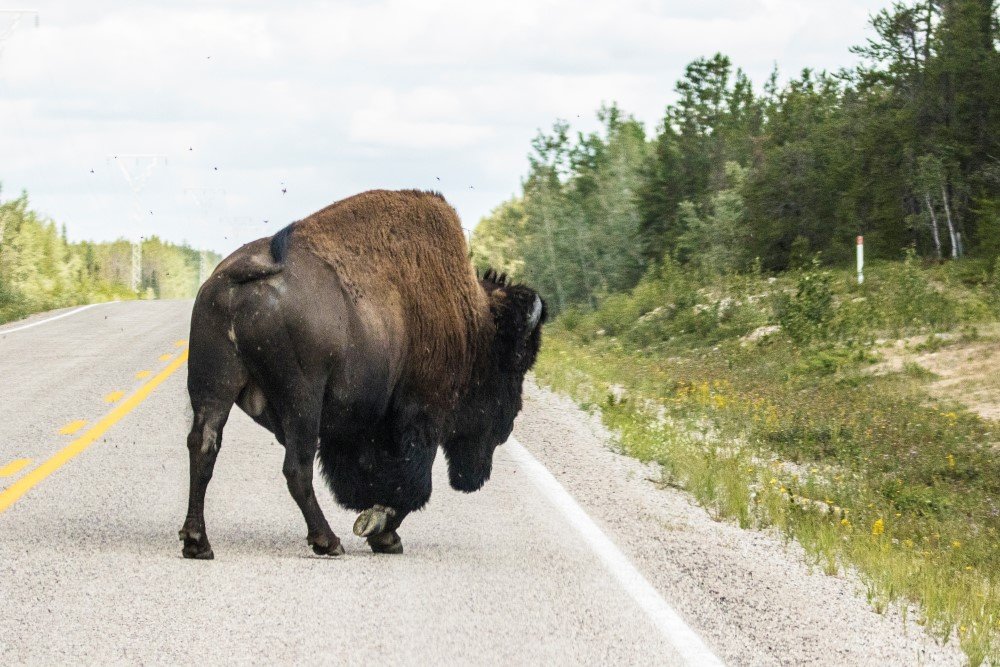
A 900kg-plus mobile road block. Bison are a common sight on roads in the region.
These facts were confirmed as I flew over the park aboard a plane that did not in the slightest comply with the ‘big’ theme of the NWT. I was squeezed in the tiny plane with pilot Peter, and national parks staffers Stu and Courtney, all from the township of Fort Smith, which was to be my base for the following five days, before I would tackle the big (there’s that word again) drive north to the NWT capital of Yellowknife.
Even from the air, the park seems to go on forever; its mix of salt fields, large lakes, sink holes, boreal forest and low hills marching off to the curve of the horizon. In all that vastness is a rich concentration of wildlife, unique land formations, and the Peace-Athabasca Delta, North America’s largest inland freshwater delta system and the origin point of the nearby Slave River. If you’re a birdwatcher, this place is near heaven-on-earth; North America’s four main migratory paths intersect here, resulting in 227 different bird species residing, or stopping over, in the park. A standout – and I was lucky enough to see two of these over the course of my week here – is the whooping crane. These tall, majestic birds have a permanent nesting area in the park that, along with the delta, contributed to its 1982 UNESCO World Heritage Site accreditation.
Of course, it was the park’s namesake that I was most keen to spot from the plane and it wasn’t long before Peter circled around a particularly large salt flat to watch an adult bison and calf wandering the edges looking for feed.
Sizing it all up
I knew, not long after leaving the bison, that I would be repeating the mantra “everything is big here” more than a few times over the next week; Peter had circled around the park border and started to follow the Slave River back to Fort Smith, providing me the best chance to gain a sense of the river’s scale. And yeah, it is more than big; the Slave runs from its source in the delta 434km north to empty into the 27,200 square-kilometre Great Slave Lake. The river’s network of rapids near Fort Smith is a world-renowned whitewater-paddling destination. There are four separate sets, with some aptly titled: Pelican Rapids is named after the northernmost colony of river pelicans that reside on the river, while Rapids of the Drowned is a seriously rugged set with a name that honours those from fur trader Cuthbert Grant’s 1786 expedition who lost their lives here. It is the Mountain Portage rapids, though, that garner the most attention from paddlers as they are easily the most accessible and have nice open sandy beaches beside them.
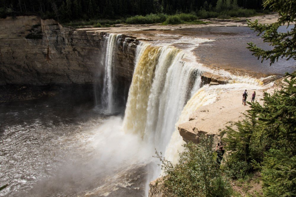
The powerful Alexandra Falls, fed by the Hay River, drop down an escarpment in Twin Falls Territorial Park.
The airborne tour had been brilliant, but I was keen to check out the area from the ground as well and was lucky enough to tag along with Seeba and Hannah as they led a tour group out to some salt fields not far out of Fort Smith. The whole process of salt coming to the surface – and the volume of it – is amazing. You can feel it crunching underfoot as you walk along and also see huge piles of it just lumped up on the sides of the salt plains. The bison love the stuff; one of the large salt piles we checked out was surrounded by bison tracks as the animals had jockeyed for position around it.
Holding the fort
Fort Smith should win an award for the most perfectly located outdoors town; the national park is only 20 minutes drive away, while the mighty Slave River is just a short walk away. After eying off the river – and the potential for exploring it in a canoe or kayak – I had already formulated a return to tackle a multiday paddle adventure.
Fort Smith has a friendly air about it; when I first rocked up to my accommodation at the Wood Buffalo Inn I was warmly welcomed by owner – and former town mayor – Peter Martselos who over the course of my time in town was a great source of information regarding the town’s history, as well as a great source of superb coffee. My hosts on most days were national parks staff and, again, they were both proud of their town, and very knowledgeable of the region’s rich aboriginal culture and pioneer history, both of which are amazing. Fort Smith’s national parks office has a great information centre and also a kick-arse museum (complete with bannock – an aboriginal damper-style bread – cooking classes) that showcases the area’s aboriginal, European and natural history. It is a long haul for visitors up here but Fort Smith and its surrounds make the effort more than worth it.
It’s easy to keep busy
My second day was another cracker; I accompanied two parks workers, Amy and Caitlin, out to Pine Lake to check it out and was lucky enough to spot something that was either a wolf or (more likely) a young black bear bolting for the treeline just as we entered the park. This was topped off by a chance encounter with two sandhill cranes, a tall, grey-coloured bird (they can reach up to 1.7m in height). This was followed not long after by our arrival at beautiful Pine Lake, which is fed only by rainwater and is the result of five sinkholes joining together. The water is crystal-clear and with cabins here, it would be a great destination for a family stay, way out in the sticks with just the lake and a billion-odd stars at night to keep you company.
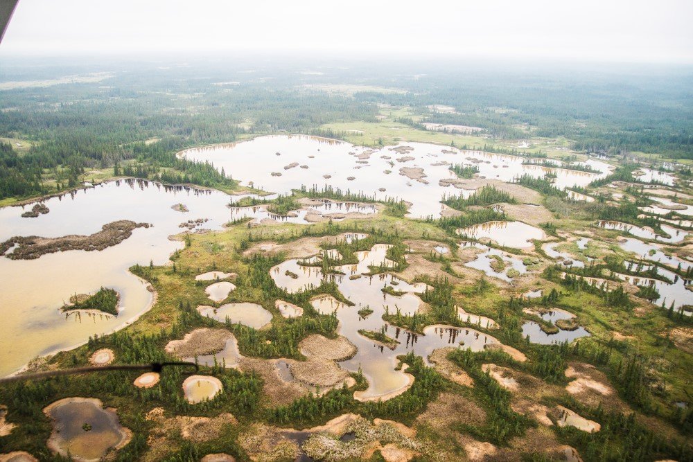
The national park’s sheer number of sinkholes – and their size – is only apparent from the air.
A return to town for lunch was followed by a visit to the Rapids of the Drowned with Sean and Alicia from the parks office. It was here Cuthbert Grant’s 1786 expedition came to grief, through a very simple but fatal error. Grant’s plan to run the rapids hinged on sending the most experienced group of paddlers down first and, if they thought it safe, they were to fire a shot to signal the others to come through. It ended up being too dangerous but one member of the first party spotted a bird and tried to shoot it for food. Of course, when the second group of paddlers heard the shot they thought it safe to come through. All five canoe occupants drowned. Ironically, we spotted a kayaker playing in the troughs of the rapids on the river’s far side – his experience in this type of water was clearly evident.
Over too soon
Another day in Fort Smith meant another exploration of its surrounds, this time with some hiking as Alicia and I headed out to inspect the Pelican Rapids. They are about a 30-minute drive from town, followed by a 45-minute one-way hike through some beautiful boreal forest. Some viewpoints along the way showcase the serious damage wildfires can do to the region; looking out to a fire-ravaged section of the forest was like looking at a collection of grey, skeletal forms. The final section of track to the rapids is steep and rugged but easily negotiated if you take it slow. The reward is incredible, and at the time I thought Pelican Rapids were even more impressive than those I had seen the previous day. While the rapids had looked big even from the air, up close they were seriously imposing. They are 3km wide and flow at a seriously fast pace, with plenty of hydraulic action at various drops along the way that can easily entrap watercraft. The roar of the rapids was incredible and it was no effort at all to sit and just soak it all up for 30 minutes before heading back for my next, and final, sojourn from Fort Smith.
I later accompanied Alicia and Sean out to Grosbeak Lake on that last afternoon. We walked across some salt flats dotted with thousands of rocks, all pitted from the salt, which seemingly transformed the place into a sunlit moonscape. Amazing stuff!
The long road
I am a big fan of long drives through vast landscapes so, even though I was leaving Fort Smith and its hospitable people, I was looking forward to the 786km trip along the Mackenzie Highway to Yellowknife. I was accompanied by my usual playlist of 90s rock music, the NWT’s big skies and, as it happened, a few of the area’s biggest residents. I had only seen bison from the air up to this point, so getting up (very) close to the big bull that was taking up both lanes of the highway was amazing. These things are huge; a male wood bison can top out at 900kg-plus, so it was easy to understand my reticence in regards to trying to get around the thing. Thankfully the bison eventually moved over to the side of the road to feed on the long grass there, and I continued on to my prearranged date with some waterfalls.
There’s a lot to see over the course of a long drive and this was proved once again on this Mackenzie Highway sojourn, with the highlight of my penultimate day here being Alexandra Falls. Fed by the Hay River, the 32m Alexandra Falls is part of the Twin Falls Territorial Park, sharing its inclusion with nearby Louise Falls. It is beautiful; there’s just something about the sound of a powerful river that gets me every time and the Hay, like other rivers in NWT, delivers that feeling in spades. Even allowing for it being a popular day stop for tourists, it was easy to find my own space here and just chill out and soak up the sound of that raw power. The park has a great campsite, which I had planned to stay at for the night, but it was still relatively early when I’d finished viewing the falls so I continued on.
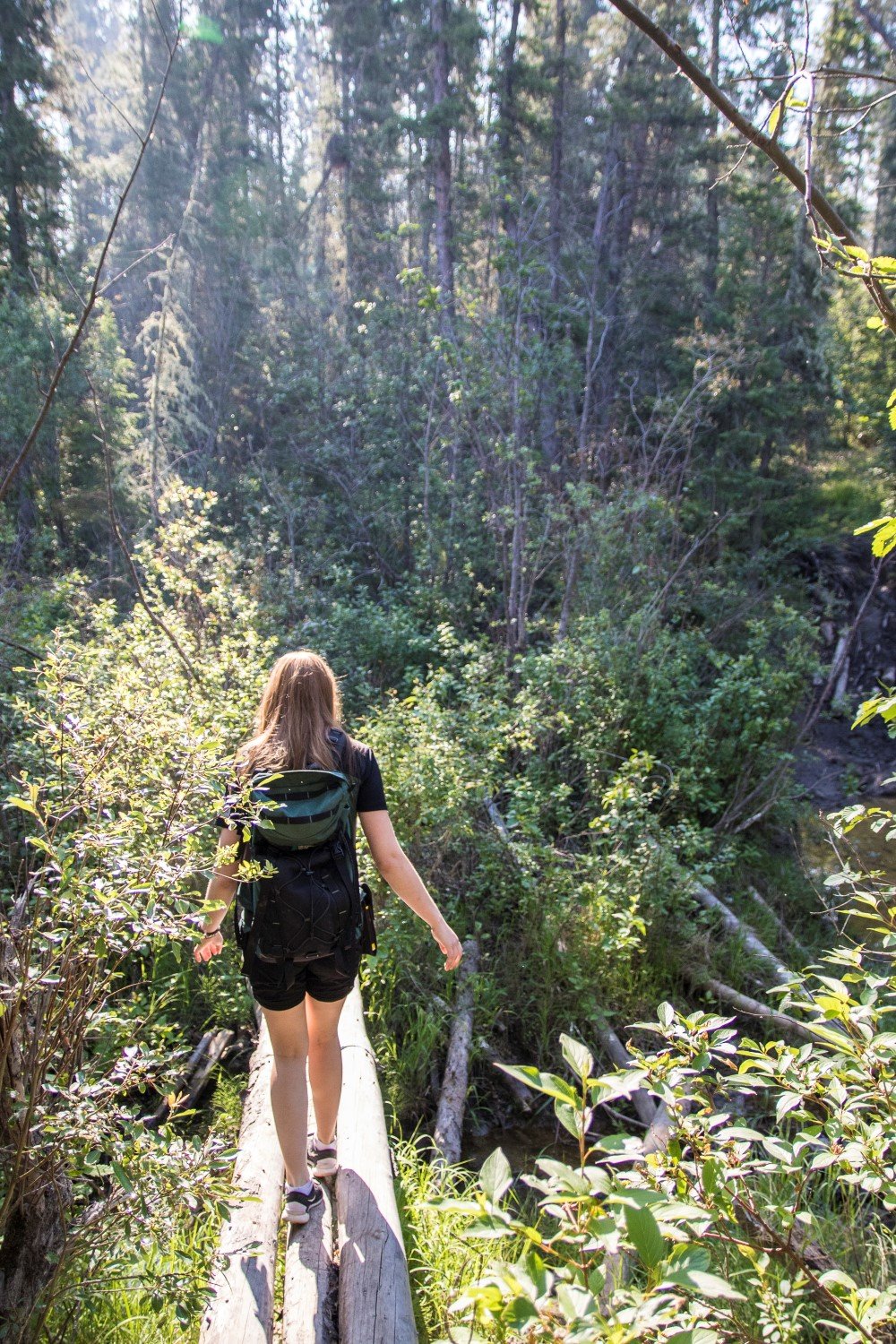
Balancing act. Tackling the track through dense forest to Pelican Rapids.
The NWT is a territory dominated by water. The multitude of lakes and big rivers is amazing, and my last day-and-a-half here brought this observation to the fore, firstly when I crossed the 1.1km De Cho Bridge across the immense Mackenzie River, then, after driving for a few more hours, when I finally reached Yellowknife. The NWT capital, Yellowknife is nestled on the shores of Great Slave Lake, which does a convincing job impersonating an inland sea; it covers an area of 27,200 square kilometres. So yeah, like everything else in the NWT, the lake is big…
This was my second visit to the Northwest Territories and, just like my previous trip here, it was a combination of much excitement and some frustration. The excitement stems from the fact this place is one of the world’s last truly wild places that offers a lifetime of amazing adventure opportunities. The frustration stems from the fact the place is so big, which meant I only had time to sample a teasing glimpse of what could be experienced on a more extended stay. But yeah, that makes for the perfect excuse to return…
The essentials
Getting there: Air Canada flies direct from Sydney to Vancouver. From Vancouver, Air Canada flies to Edmonton. From Edmonton, Northwestern Air flies to Fort Smith. See www.aircanada.com and www.nwal.ca.
The adventure: Parks Canada has extensive information on its website regarding Wood Buffalo National Park (and all other Canadian parks). See www.pc.gc.ca.
Fort Smith is a brilliant base from which you can explore the national park and the surrounding region, and it also has a number of outdoor events throughout the year. See www.fortsmith.ca.
Accommodation: The Wood Buffalo Inn is in the centre of Fort Smith, right near the museum, supermarkets and the national parks office. The Martselos are the perfect hosts, with loads of information and stories on the area. See www.woodbuffaloinn.com.
More info: For all things Northwest Territories, see www.spectacularnwt.com
Australian Geographic Adventure was a guest of Northwest Territories Tourism and Destination Canada Tourism Commission.


