
When we were much younger, the disparity between mine and Chris’s ability to read a map was blatantly obvious. After I had got us hopelessly lost early in the mountain bike orienteering stage of an adventure race, Chris clawed us back into the top of the standings with his exceptional ability to recall that you should Never Eat Soggy Weet-bix.
I was reminded of this late one afternoon, half an hour after I’d determined we were half an hour from our first camp on the Tongariro Northern Circuit. It turned out we were still two hours away, and we got in just before the sun dipped below the valley’s rim. Chris carried the map from then on; a real hit to my value as a hiking partner. My only two real contributions to this trip so far had been buying the map and organising the rental car to get from Auckland to Tongariro.
We’d flown into Auckland to tackle the 43km, four-day Tongariro Northern Circuit, one of New Zealand’s Great Walks. Situated almost smack-bang in the middle of the North Island, it’s probably most famous as the setting for Peter Jackson’s Mount Doom (Mt Ngauruhoe) in his Lord Of The Rings trilogy. Watching those films details the extent of research I put into the trip beforehand.
A very pleasant surprise
Given the ‘relaxed’ attitude I’d taken into this adventure, I’d fully expected we’d spend four days walking through volcanic badlands; all greys and browns and sulphuric stinks. But, genuinely, until we walked through a small stand of temperate rainforest on the descent to an actual waterfall, I was still expecting it to be dull. Instead, we spent four days traversing some of the most diverse country I’ve ever walked.
The walk starts behind Whakapapa Village, a ski resort town south of Tūrangi. Even in February, the surrounding mountains were topped with snow, indicating the overnight temps we could expect for the next three nights. As we reorganise our packs in the carpark on day one, we replaced some lighter garments with heavier ones. Although the forecast was perfect for the next four days, the walk has a reputation for rapid weather changes and ferocious winds. We got lucky.
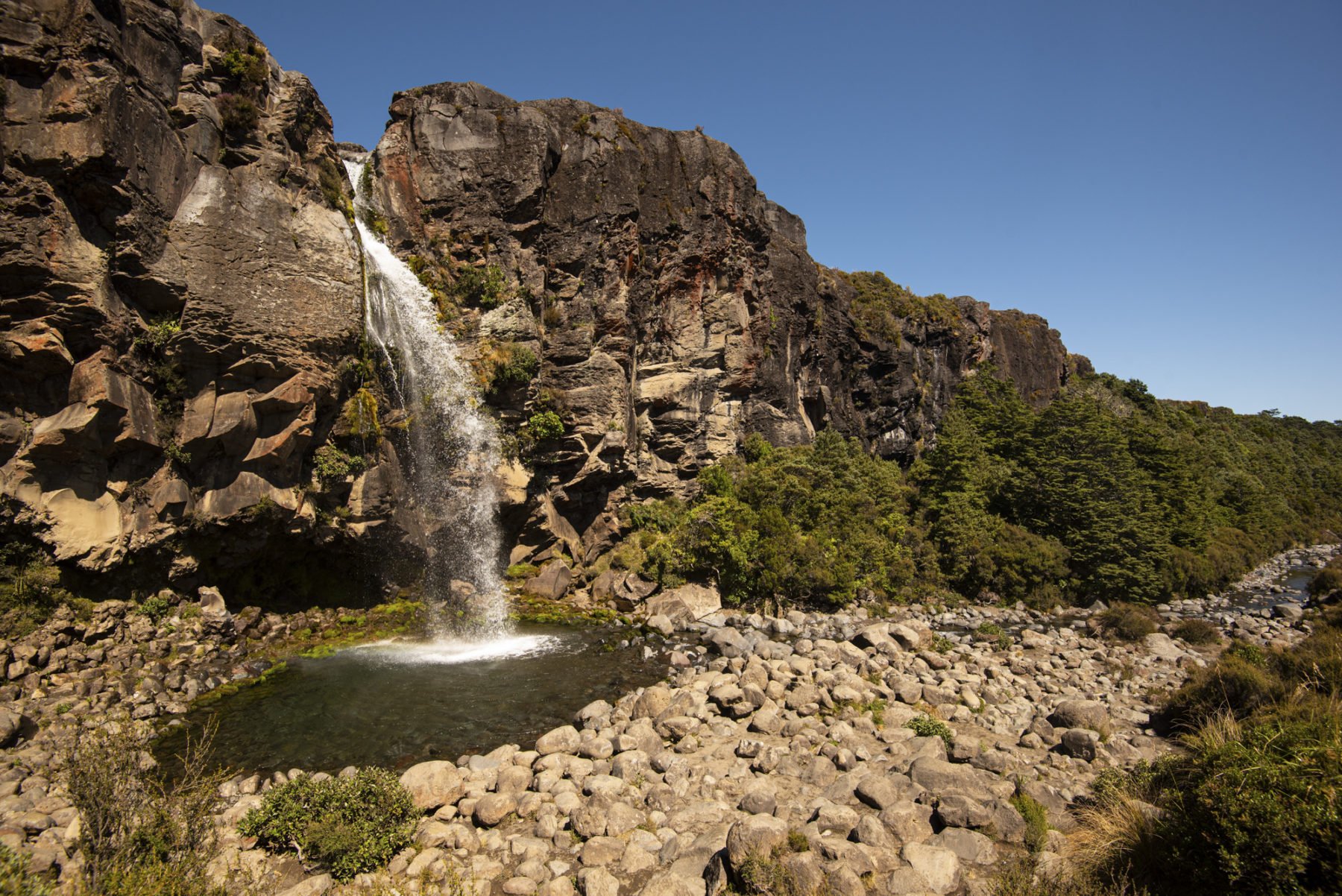
Joining the trailhead, hundreds of day walkers clog the way, initially headed in the same direction, either for Taranaki Falls or Tama Lakes. In our exuberance, we outpace most of them (except for the woman who jogged past us in jeans!) as we traverse the graded, largely flat trail for the first couple of hours. We dip down to Taranaki for morning tea, a short, sharp descent through dense beech forest which opens up onto the 20-metre fall. Then we pay for the picture ops as we lug our packs back up 100 or so uneven steps.
The crowds thin, back on the main track to Tama Lakes and Waihohonu Hut, and we start to pick out the people who’re likely to be our hiking companions for the next few days. The Northern Circuit is so popular through summer that the huts and campsites book out with walkers from all parts of the world. (The NZ hut system is the envy of the hiking world. The NZ Department of Conservation manages over 950 huts in NZ.)
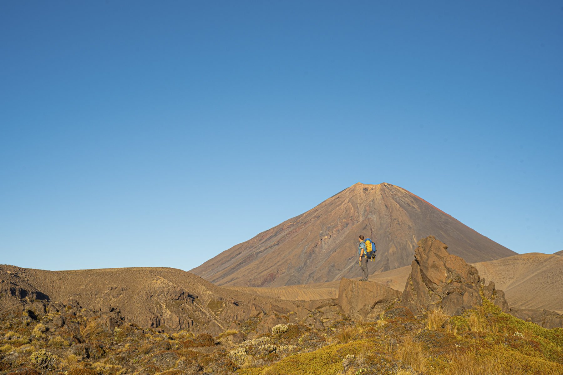
The track gets more interesting for the next few kilometres to Tama Saddle as it falls and rises gently with the terrain. We cross a few creeks and settle into our strides, packs and the altitude (1300 metres is high for us coastal Aussies), but relish the chance to take a lunch of cheese and bickies looking over Lower Tama Lake, a 15-minute detour from the main trail. Sitting at Lower Tama Lake, one of two water-filled volcanic craters, we decide to exert ourselves on the climb, 130m of elevation, to the Upper Tama viewpoint, which overlooks the upper lake and takes in the most spectacular view of Mt Ngauruhoe. Most people, it turns out, hide their packs in the scrub at the bottom. Not us, though. We stupidly keep them on our backs and fight for every inch of elevation as the crumbling, volcanic shale track shifts under every step until we hit the top. It’s worth it. We’re only at lunch on day one, but we’re looking over a volcanic explosion crater straight at Mount Doom!
The rest of the day, we drop elevation from a peak of 1440m to 1100m at Waihohonu Hut as we follow a babbling brook through unexpected fields of native (and introduced heather) wildflowers. It’s pleasant, except for the part where I proclaim we’re nearly there, but we clearly aren’t. We stop a few times, filling our water from the stream and generally loving life.
Waihohonu is the largest of the three huts with 28 bunks, a great camp kitchen and a sprawling deck that captures the last of the afternoon sun. After setting up our tent in the nearby campground, we join the throng on the balconies to swap tales of the day and get insights about the next stage. After a 19km, 550m day, we both sleep well.
Short, but oh, so steep
From Waihohonu to Oturere Hut is the circuit’s shortest day, but in just under 9km, we’ll climb another 550m. Before we load our packs, though, we grab water bottles and bladders for the 4km stroll to Ohinepango Springs. This is a beautiful spot. The water here is icy cold and as pure as it gets, although I decline to take a dip. On the way back, we detour slightly to the Historic Waihohonu Hut, which was built in 1904 and used by pioneering skiers and hikers until it was replaced in 1968.
Packs packed and back on, we start the hike in earnest. There’s no easing into day two, as from Waihohonu campsite beside the stream of the same name, we gain 150m of elevation in the first kilometre before losing it all again a kilometre later. It’s brutal but spectacular as we tramp through lush beech forest over root steps before following a ridge of volcanic scree to the first highpoint. The drop winds through more incredible forest before emerging at a swiftly flowing stream in country that feels worlds away from volcanic badlands.
From here, we climb and climb The next 7km is almost always up, and we quickly leave the lush forest and streams behind to trudge along exposed, rocky ridges following a track marked by poles and relentlessness. At times Chris and I walk in step; at others, 100 or so metres separate us as we deal differently with the climbs. I take a lot of photos of his back. The few hikers coming the other way always tell us it’s not much farther, but they’re coming downhill, so can’t be trusted.
With about a kilometre to go, the contour lines on our map combine into one thick stripe, and all we can see in front of us is sheer cliff. All we can do is follow the poles and trust they wind a safe path up because it looks unscalable from our perspectives. It certainly feels like an achievement at the top.
Despite the elevation, we’d only walked three hours this day, so we get into camp at Oturere early in the afternoon. Already the benches and balcony out the front are filled with walkers enjoying early dinners in the sun. We set up camp and settle in for the arvo, relishing the ‘early mark’ as we downplay how we feel about the past 9km of walking with new campmates.

I’m surprised to learn that a giant valley opens up just over the rise, which hosts Oturere Falls. Its gentle drops create near-perfect pools, which we wander down to for a welcome dip in the sun-warmed water. Again, I’m amazed by the diversity of the landscape as we look over a green valley sitting in a waterfall, a volcano behind us.
Interestingly, over its 2500-year history, Mt Ngauruhoe has erupted, on average, every nine years, but not since 1975, a fact we try to ignore that night as we settled into our tent within the theoretical debris zone of the active volcano.
The sting in the tail of the Northern Circuit
We wake early to another perfect day. From Oturere to Mangatepopo Hut is set to be the most demanding day of our hike. Although we pack up in the dark, half the campsite has emptied before us. After a quick brekky and coffee, we set out, initially revelling in the flat walking along the floor of Oturere Valley for the first hour or so. Then things get serious, quickly.
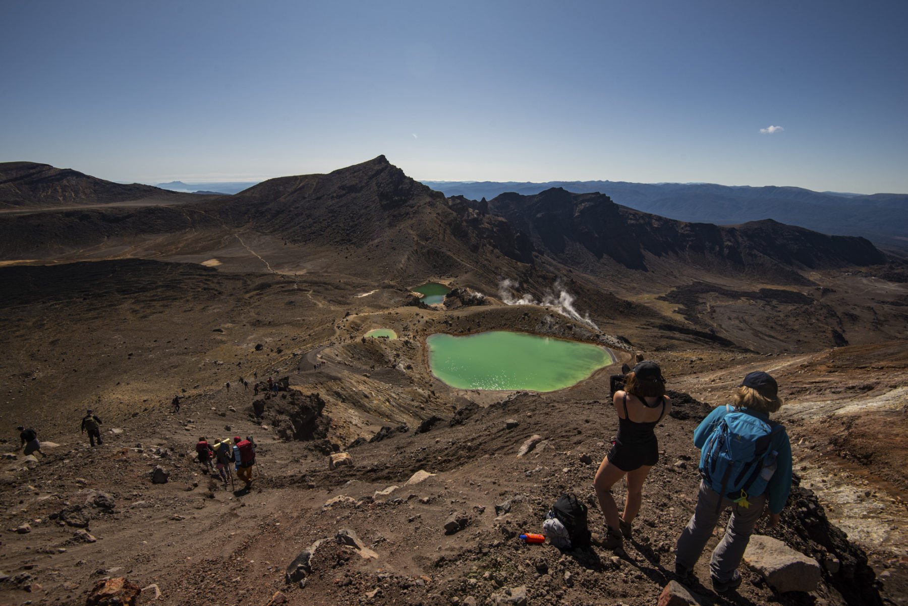
We’re met at the head of the valley by a sulphuric stink and a narrow, steep ridge that climbs nearly 300m in about a kilometre. I’m not sure how heavy my pack is, but I resent every gram of it as we scramble, climb, and trudge up the spine to Emerald Lakes. It takes nearly an hour.
The climbing isn’t done, though. The stunning Emerald Lakes sit at about 1700m elevation, but our highpoint, less than 1km away, is 1868m. There’s no track, either. So while school groups, tour groups and international tourists in Tommy Hilfiger shorts (and not much else) slip and slide down the steep, loose scree, we, with unknown kilograms on our backs, wend our way up it. Like walking up a sand dune, but harder, each step slips backwards, so Strava doesn’t do justice to the distance we’ve climbed.
It’s all worth it, though. At the top, we literally look deep into the heart of volcanic Red Crater (no lava, though, disappointingly) and get some of the best views of Mt Ngauruhoe and its perfectly volcanic cone. Plus, we know that this is the high point, and apart from one short, easy climb later on, we don’t walk uphill again that day.
Although maybe we underestimated how difficult the descent would be. From 1868 metres, we drop 600 metres of elevation over about 8km. From Red Crater, it’s a scramble down the side of the mountain on a busy track against the traffic. We get a slight reprieve crossing the flat South Crater, although it crosses our mind the volcano hasn’t erupted in a while, and we’re walking on where the lava would go if it did.
After South Crater, we start our climb down the Devils Staircase, and even going down, it deserves the name. It’s relentless as it winds down the valley. Tantalisingly, we can see Mangatepopo Hut in the distance, but it never seems to get any closer. I’m glad we’re not walking up it. Knees, thighs, and shoulders protesting, we finally get to the bottom. It’s with sheer relief we finally stumble into camp, our last of the walk, and emotionally, the finish line.
Tomorrow’s hike out is short – just 8.5km with a general loss of elevation. And although it winds prettily through the purple-green fields of heather (stunning, but a pest the DOC is trying to eradicate), it’s only a two-hour stroll. We’re done before breakfast and buy coffee and pies from the food van at Whakapapa Village. Tonight though, we pass around the bottle of Scotch we’ve carried for 40km or so (pre-COVID, when passing around a bottle was socially acceptable), eat all our remaining food and swap social handles with our hiking companions as we sit on the hill watching the sun set.


