Aviation: The adventures of Love Bird and Diamond Bird

ON TUESDAY 17 JUNE 1930 Captain Frank Neale was at the controls of a large ANEC III bi-plane called Love Bird as it bumped to a stop on a patch of sand and scrub not far from Uluru and he became the first person to land an aircraft near this spectacular monolith.
Frank Neale’s aircraft, Love Bird (VH-UGF), was one of two that had been hired by entrepreneur Donald Mackay to survey a huge tract of unknown desert country north-west of Alice Springs. But what was Donald Mackay really doing here? Why was he spending his own money surveying the Great Sandy Desert for Australia’s Department of Works? Was he hoping to find the fabulous gold reef that lured Lewis Lasseter to his death in the Petermann Ranges? Or was it just public-spirited altruism? Donald Mackay found no gold — only huge areas of red sand and a dry salt-lake which bears his name today.
GALLERY: AVIATION IN 1930
DONALD MACKAY WAS BORN in 1870, the son of a wealthy pastoral family from Yass in New South Wales. His father’s death in 1890 left young Donald with a large inheritance which enabled him to pursue a passion for exploration and adventure — so he set off to see the world, travelling to many places, including China and Japan. Back home in 1900, he rode a bicycle 17,000 kilometres around Australia in 240 days a record for those times. In 1908-09 he explored the remote headwaters of the Purari River in Papua before spending several years sailing around Pacific islands. In 1925-26, with geologist and anthropologist Dr. Herbert Basedow, he surveyed and prospected through the Petermann Ranges south of Lake Amadeus, but soon realized that maps of the area were hopelessly inaccurate and quite misleading. Two years later, in 1928, he explored Arnhem Land for four months with a team of camels and ponies — again with Dr. Basedow.
These expeditions were all financed from Donald Mackay’s own pocket, and he generously presented copies of his reports and survey maps to the Australian Government and Mitchell Library. By 1930 he was ready to set off again, this time to correct the mapping errors he’d come across during the Petermann Ranges expedition of 1926. But now he would do it differently; he would use the latest in technological aids for surveying — aircraft.
VH-UEZ Diamond Bird VIEW GALLERY
For such an expedition he needed expert pilots, radio operators and navigators as well as ample fuel supplies at a remote base where an airstrip could be cleared in the scrub. Donald Mackay began the task of assembling a team of people and all the equipment he needed to accurately map the unknown country north-west of Alice Springs.
The aeroplane which Donald Mackay selected for this 1930 survey was an innovative, three-engined Australian-made monoplane called the Lasconder. It was to be supplied by Australian Aerial Services Limited (AAS) — the flying section of a group of companies under the leadership of aviation entrepreneur H.J. Larkin. Jim Larkin was an Australian soldier who had been wounded at Gallipoli before joining the Royal Flying Corps in 1916. After training as a pilot he was posted as a Captain to No.5 Squadron in France where he earned the Croix de Guerre for “…valuable aerial reconnaissance and photography during the German retreat from Bapaume…” in March 1917.
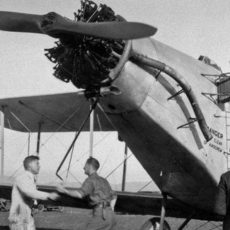
Another branch of Jim Larkin’s enterprise was the Larkin Aircraft Supply Company (LASCO) which designed and built aircraft in Melbourne for the RAAF. The company also designed various commercial versions, such as the single-engined high-wing monoplane, Lascoter; and the new three-engined monoplane, Lasconder — the aircraft selected by Donald Mackay. However, just days before the expedition was to leave Melbourne, the Lasconder damaged a wing and part of the undercarriage when Jim Larkin was piloting the aircraft during a landing at the Coode Island airstrip, after a flight to test newly-installed radio equipment. Jim Larkin contacted Donald Mackay and offered to replace the damaged Lasconder with two large ANEC III (Air Navigation Experimental Company) single-engined biplanes — each powered with a 480 hp Armstrong-Siddeley Jaguar 14 cylinder radial engine. The ANEC III was originally designed and made in Britain, but three of them were brought to Australia and modified by Jim Larkin’s company for use as mail and passenger transport aircraft. In Australia these modified aircraft were given the name Lascowl; each could carry nine passengers, or the equivalent weight of fuel and equipment, and had an operating range of about 700 kilometres at 140 km/hour.
The two pilots Mackay hired for these ANEC III Lascowl planes were both Larkin company men:
• Frank Neale (1895-1979) served with Jim Larkin in the RFC during World War I, and after coming to Australia in the 1920s, had a remarkable safety record — flying something like 3,000 hours on various commercial airlines. He was probably one of the most experienced pilots in Australia at that time.
• Bert Hussey, gained his commercial licence in 1927, and was one of several pilots who later joined QANTAS when the Larkin enterprise folded in 1933.
The radio operator selected by Donald Mackay for this expedition was Howard Kingsley Love (VK-3BM), a leading Victorian amateur radio expert who had been installing communication networks for the RAAF. Both of the expedition’s Lascowl aircraft were fitted with long-wire aerials, and a wind-operated generator on the wing powered the radios. Another receiver, with its own petrol generator, was carried for installation at the base camp. Kingsley Love also held a pilot’s licence — in the event that he might have been needed to fly one of the aircraft in an emergency.
The key person on this aerial survey was Commander H.T. Bennett RAN F.R.G.S., an expert navigator who had recently been in charge of an Admiralty survey team charting waters around the Great Barrier Reef on HMAS Geranium.
Philip Crosbie Morrison M.Sc., a young reporter working for the Melbourne Argus, was part of the team. He was also a graduate biologist who had been on the Barrier Reef survey with Commander Bennett in 1926. The Argus had been given exclusive rights to the story of Donald Mackay’s expedition, so the young Crosbie Morrison, who was probably the only staff reporter with any experience in expeditionary work, soon acquired many tasks. His duties were to:
• Send regular news items of the expedition’s progress to the Melbourne Argus.
• Carry out a biological survey of the area traversed by the expedition.
• Make a complete photographic record of people, places and events.
NOT THE LEAST OF Donald Mackay’s problems was the need to stockpile a large quantity of aviation fuel in a remote part of Australia. To accomplish this, he arranged for a well known inland personality, Bob Buck, to transport 9,000 litres of Shell aviation fuel, lubricating oil, and one tonne of spare parts, provisions and equipment to Ilbpilla waterhole in the Ehrenberg Range, 380 kilometres west of Alice Springs.
Bob Buck set out about two months before Mackay’s expedition flew out of Melbourne. He took with him five Aboriginal guides and eight camels. His task was to find Ilbpilla waterhole, set up a camp and clear a landing strip about 700 metres square. It should be remembered that because of the very inaccurate maps in those days, the actual position of the Ehrenberg Range was not known with any precision. Two weeks later a larger party of seventy camels, with two Afghan teamsters (Ali Mahomet and Mahomet Bux), followed Bob Buck to the Ehrenberg Range, carrying all the tents, fuel and provisions for the base camp. In later years Bob Buck became well known as Australia’s quintessential ‘intrepid bushman’ — after the controversy which surrounded his discovery of gold-seeker Lasseter’s body in a cave 200 kilometres south of the Ehrenberg Range.
So, with a base camp established by Bob Buck at Ilbpilla waterhole in the Ehrenberg Range, the Mackay Aerial Survey Expedition took off from Melbourne on 22 May 1930 in the two ANEC III Lascowl aircraft — Love Bird (VH-UGF) and Diamond Bird (VH-UEZ). First stop was Canberra where Donald Mackay joined the expedition, carrying with him a letter of goodwill from the 86 year old desert explorer William Tietkens, who had been on Ernest Giles’ Gibson Desert Expedition in 1873. Tietkens had also commanded his own expedition to explore country around Lake Amadeus and the Ehrenberg Range in 1889, and was the first man to photograph Uluru.
Prime Minister James Scullin greeted members of the Mackay expedition in Canberra and said that “… Mr. Donald Mackay was to be congratulated on the unselfish purpose of his hazardous venture…” Later, the expeditioners were hosted to lunch in Parliament House by James Scullin and other politicians, including the legendary Billy Hughes.
THREE DAYS LATER Mackay’s Aerial Survey Expedition was flying over the rugged MacDonnell Ranges south-west of Alice Springs when Bert Hussey, piloting Diamond Bird, felt the engine splutter a few times before it gradually lost power. Luckily they were not far from the Lutheran mission at Hermannsburg, where both aircraft made a comfortable landing. It was soon found that a bent inlet valve had put one of the fourteen cylinders out of action. Spare parts for the aircraft had already been carried by Bob Buck’s camel teams to the Ilbpilla camp, so Frank Neale was sent on in Love Bird (VH-UGF) to bring back a spare cylinder from the Ilbpilla base camp. The only way he could find the cleared landing strip at Ilbpilla was to watch for the smoke signal lit by Bob Buck each day. This pre-arranged signal nearly miscarried because of the fires lit by the many Pintubi Aborigines who lived in the surrounding country; the conventional sign from one Aboriginal camp to another is a single column of smoke, and it’s generally regarded as polite to answer such a ‘smoke’ in the same way. When Bob Buck fired his first smoke signal at Ilbpilla it was answered north, south, east and west by many Aboriginal ‘smokes’, which would have totally confused any pilot searching for a marker! Bob Buck had to send his Aboriginal guides to all nearby camps with frantic requests that no ‘smokes’ be lit until the ‘great birds’ arrived. Fortunately Love Bird was delayed at Hermannsburg that first day, so that the confusion at Ilbpilla had no serious consequences.
In his regular reports as ‘special representative’ to the Melbourne Argus, Crosbie Morrison described what he saw at Ilbpilla:
“…we found a comfortable shelter of mulga branches made ready for us, in the form of a crescentic breakwind against the prevailing easterlies, with two leafy bowers, one for a dining room and the other for a dormitory. The workroom was an old tent fly, and there were two other tents for our leader and the native camp assistants … The work tent was used as a photographic changing room, all changing being done inside a light-tight bag by touch alone. It was also the storeroom for all instruments and gear that required to be readily accessible, and it contained the rough and ready tables of petrol crates on which we worked. One large table was reserved as a chart table, and was the exclusive property of Commander Bennett. Under the same shelter we fixed the wireless receiver … With a 4-valve set we received the time signals each evening from 3LO Melbourne through heavy static, and also kept in touch with the surveying ’plane when it was away from base …”
However it wasn’t long before radio operator Kingsley Love regretted leaving behind the well-tested equipment which had been damaged when the Lasconder crash-landed in Melbourne. The dry soil made ‘earthing’ difficult, and atmospheric conditions at Ilbpilla were very bad on the short-wave frequency they were using. Stations listening to their messages, on call sign 3BM, were asked to keep replies going for at least five minutes! But worse was to come. The expeditioners had been at Ilbpilla for only a few days when disaster struck: inadequate cooling of the Douglas motor cycle engine that was used to generate power for the radio, caused one of the two pistons to shatter into small pieces. The damaged piston was removed, and after reassembly the engine ran as a ‘one lunger’, but the unbalanced motor required at least four people to hold it down! This caused much amusement in the camp, until the remaining cylinder ultimately failed. Radio transmission could now only take place while Love Bird was airborne — using the wind-driven generators. But there were more disasters in store for Kingsley Love: the high tension armature in the wind generator burned out, and they had to rely on a small hand-operated, low-power 600 volt generator (now in the DCA Museum at Essendon Airport).
But the daily survey flights went on. In the work tent at Ilbpilla details of the desert country north and west of the camp were quickly filled in by Commander Bennett as each survey flight brought new information. The Argus representative Crosbie Morrison described how the map was compiled:
“…On a blank map, with Ilbpilla at the centre, 24 radiating lines were drawn at intervals of about 10 degrees from the base to the limit of flying radius — about 240 miles [380 kilometres]. Courses were then set for each day’s flying — out along one radius, around the circumference and then back along the adjoining radius. By means of direction finding sights on each side of the machine the bearings of all conspicuous land features were taken from several positions on the flight, and these were plotted on a rough map during the flight. At the end of each flight the distance flown had to be corrected for direction and course of wind, and all distances on the rough sketch of the country had to be similarly corrected before being incorporated in the main map, which was permanently set on a table in the work tent. Day by day the big map grew, and, as it grew, the importance of the work became more evident. Mountains and hills appeared where previous maps showed nothing … Much interest centred round the first flight to Lake Amadeus, for almost every map in the possession of the expedition showed it differently in position and extent …”
ON 9 JUNE 1930, about halfway through the survey, Love Bird flew over a large, shallow salt lake on the Western Australian border. This previously unknown lake was marked on Bennett’s map as “New Lake”, but geographers later officially named it “Lake Mackay” in honour of the expedition’s leader. Another lake, north-west of Lake Amadeus, was named “Lake Neale” after pilot Frank Neale. Commander Bennett had his name perpetuated in yet another un-named lake 100 kilometres north-east of Ilbpilla —“Lake Bennett”. Much later, Bob Buck had a lake named after him in the Tanami Desert. And “Lake Anec” in the Gibson Desert may have been named after the two aircraft used by Donald Mackay on this, his first survey flight.
No sooner had navigator Bennett plotted the site of Lake Mackay than he fell seriously ill with dysentery, and was flown to the Hermannsburg Mission settlement for medical attention.
On Friday 13 June there was another set-back: two cylinders in Love Bird’s engine began blowing oil after take-off. Pilot-mechanic Frank Neale was called on to perform major repairs. Then, just after these cylinders were replaced, Bert Hussey, pilot of Diamond Bird, also came down with dysentery and had to be flown to the Alice Springs hospital for treatment; and then Kingsley Love was struck down with a mild attack which kept him camp for a few days.
Frank Neale still seemed healthy enough, and on 18 June he took off from Ilbpilla, crossed Lake Amadeus to circle the monolithic Uluru (Ayers Rock), before landing Love Bird on soft sand about two kilometres from its base. Captain Neale admired the scenery, and said that Uluru was ‘one of the finest sights’ he had seen — but perhaps he should have been more concerned about being able to take off again! To do this, members of the party hacked down the scrub to lengthen and improve the sandy runway.
For the return to Melbourne, Donald Mackay intended to make a temporary camp at Uluru, so that both aircraft would be able to take off fully laden with enough fuel to reach the townships of Cook or Ooldea on the transcontinental railway line. Frank Neale made several flights from Ilbpilla to Uluru, transferring fuel and provisions so that the journey home could begin. Meanwhile, Commander Bennett and Bert Hussey had recovered from their attacks of dysentery, and returned to Ilbpilla.
ON MONDAY MORNING, 23 June 1930, the Mackay Aerial Survey Expedition began the journey home. After leaving their base at Ilbpilla, the two ANEC IIIs flew to the camp at Uluru, where both aircraft loaded enough fuel for the 600 kilometre flight to Cook. But, just as Love Bird and Diamond Bird were taking off from Uluru’s makeshift airstrip for the last time, Crosbie Morrison, leaning from the open window of Diamond Bird, dropped his camera into the scrub below. Several months later the desert explorer Michael Terry found it, still intact, and returned the camera and its film to a very surprised and delighted Argus correspondent.
In a few days Love Bird and Diamond Bird were home at the Larkin airfield on Coode Island, Melbourne after five weeks of almost constant travel. And, despite many problems, Donald Mackay seemed satisfied with the results:
“… We have put on the map of Australia an area of about 40,000 square miles, most of which had never been seen previously by white men … The expedition has demonstrated conclusively that the only way to map such country as the interior of Australia is by aerial survey … To take up the flag where the early explorers put it down, and to bear it further into the unknown, is a privilege shared by few. This has been appreciated throughout the expedition. The area which we have mapped is, unfortunately, of little use to anyone. The country becomes progressively more barren as one pushes westward, and mineral wealth is the only thing likely to attract men into it. The map of our work will be redrawn in Melbourne, and I intend then to present it with accompanying data to the Federal Ministry…”
Donald Mackay made three more aerial surveys of the desert country in north-west Australia. In 1933 he mapped much of the Great Sandy Desert from two base camps — one at Docker River in the Petermann Ranges, and another at Roy Hill near Port Hedland. The Roy Hill expedition nearly ended in disaster when Frank Neale damaged the propeller of the Percival Gull aircraft during a landing near Lake Anec.
In 1935 Mackay surveyed a large part of the Nullarbor Plain and the Great Victoria Desert from base camps along the transcontinental railway line. Donald Mackay, Frank Neale and Commander Bennett worked together for the last time in 1937, filling in blank areas of the map from a base camp in the desert near Tanami.
All of this work was financed from Donald Mackay’s own bank account, and we can only guess how much it must have cost. Donald Mackay never found Lasseter’s gold reef or any other minerals as compensation for his untiring efforts. Whatever may have been his real motives, the lasting memorial to him is a huge salt lake which few people have ever seen.
David Corke spent most of his working life as an educational filmmaker and photographer. In the 1950s, he came to know Crosbie Morrison, the Melbourne naturalist and photographer who accompanied the Mackay aerial survey. David is now in ‘active’ retirement, producing framed gallery prints from the many monochrome and colour photographs collected in his travels throughout Australia. His main interests are in wildlife and rural history.
SEE GALLERY: Aviation in 1930
All images courtesy: Series 11 – Philip Crosbie Morrison Collection, MS 13358, State Library of Victoria, Australia.


