Alpine glory: Tour du Mont Blanc, France

FEATURING ICE-SHEARED SPIRES, sweeping glaciers and alpine meadows, the Tour du Mont Blanc seems irresistible to the modern trekker.
However, when the Swiss scientist – Horace Bénédict de Saussure – completed the initial circuit of the Mont Blanc massif with some trusty friends in 1767, the Alps were feared by many for their supposedly supernatural character.
Enter to win return flights to the European destination of your choice
Through his scientific enquiry, and an offer of a reward for the first ascent of Mont Blanc, came a growing public interest in the Alps and the birth of mountaineering and trekking as recreational pursuits.
Since then, the Tour has become regarded as one of the world’s classic mountain walks.
Tour du Mont Blanc
Pen and I were lured by the prospect of majestic alpine scenery. We’d also heard about charming villages, where sturdy wooden homes crowd narrow lanes, and dreamt about sampling the local specialties – French cheese, Swiss chocolate and Italian gelato. It sounded like the perfect combination for a trek.
At 4807m, Mont Blanc is western Europe’s highest peak, and with some 400 subsidiary peaks, forms a massif that extends for 25km. Scouring the range are more than 40 glaciers, with many visible from the track.
Although the Tour doesn’t require any mountaineering skill, it is no doddle, with climbs to seven significant cols (passes) and several smaller ones resulting in more than 10,000m of elevation gain.
The Tour can be walked in either direction, with most walkers going anticlockwise, starting from the village of Les Houches, France – a short bus ride from Chamonix.
We went clockwise, starting from the Swiss lakeside resort of Champex, thus avoiding an immediate 1500m elevation gain that confronts clockwise walkers starting at Les Houches.
Another attraction of the Tour is the prospect of light packs. With villages, or refugia, located roughly every 3–4 hours walk along the route, there is no need to take a tent, sleeping-bag or mat.
Most accommodations offer breakfasts, packed lunches and three-course dinners – meaning most trekkers don’t take stoves or much food. As a result, many trekkers’ packs weigh less than 10kg.
In perhaps the ultimate indulgence, most refugia also have espresso machines and well-stocked bars to satisfy weary trekkers.
Walking near Lac Blanc with the Chamonix Aiguilles rising behind. (Credit: Ben Clark)
Grand Col Ferret, Swiss-Italian border
After a gentle introductory day, passing Swiss cows with their melodious bells, the second day brought our first serious climb, with a 730m ascent to Grand Col Ferret. With it came our first opportunity to sample local cheeses, at a dairy partway up the climb.
On reaching the Col, which forms the Swiss-Italian border, our eyes were drawn to the peaks of Grandes Jorasses and Mont Dolent, and in turn to the glacially sculpted Ferret Valley below.
The well-designed Rifugio Bonatti was our day’s end, and we enjoyed a glass of red wine on the forecourt while absorbing the view.
Directly north was Grandes Jorasses, its triangular bulk seeming to rise sheer from the valley below, and to the west the exposed ridge of Aiguille Noire de Peuterey leading up to Mont Blanc.
After watching the sun set, the stars came out, and with them several pinpricks of light high on the slopes – a sign of life in the mountaineers’ tents and huts.
Our third day dawned fine, providing ideal conditions for one of the Tour’s highlights – walking the alpine ridge of Mont de la Saxe. With glacier-skirted peaks on our right, and ranges running into the distance in every other direction, at times it seemed hard to know where to look.
Enter to win return flights to the European destination of your choice
We stopped near the ridge’s high point – Tete de la Tronche – to study the now familiar Grandes Jorasses, much as Edward Whymper and his guides did from this spot before attempting its first ascent in 1865.
After such a high, the 1km descent into Courmayeur seemed unfair, promptly losing all our hard-won elevation. On advice from fellow trekkers, we took the cable car from town up to Pointe Helbronner for a closer look at Mont Blanc.
Located on the southern margin of the Glacier du Géant, it offered a panorama over much of the upper massif. The cable car is also popular with mountaineers, who use it for quick access to nearby peaks.
The striking Dent du Géant (Giant’s Tooth), was a popular option – we spotted six climbers at various stages of ascent. Through binoculars we also counted 30 climbers lined up on the summit ridge of Mont Blanc.
As the highest peak in Western Europe, the clamour for the summit is intense, with roughly 20,000 people attempting it each year.
The climb from Courmayeur was particularly demanding, with 1000m of elevation gain before lunch. Despite thinking my legs would be strong after the past three days, it was not getting any easier. Conversely, Pen was relishing the challenge, tackling the ascent with vigour.
Mont Blanc had centre stage on this fine day and our grandstand position demanded extended appreciation, so we prepared an alfresco lunch featuring the Italian staples: tomato, pesto, cheese and bread, and took in the view.
Col de la Seigne, French-Italian border
En route to the first col – Col de la Seigne, which marks the French-Italian border – we saw a bachelor herd of Alpine ibex on an adjacent rocky spur.
They continued grazing while we marvelled at their long curved horns. A mock battle reminded us their purpose was not aesthetic. Just below the col, we encountered strands of rusty barbed wire: remnants from earlier Franco-Italian border disputes.
The second col was easily countered, courtesy of a cheese wheel from a dairy in the valley that provided a much-needed calorific boost for the climb.
Soon after entering France the clouds rolled in, shrouding the peaks. We became more observant of the details in the landscape, with the yellow, amber and russet tones of autumnal foliage seemingly more pronounced. Another bonus was the trackside abundance of blueberries.
Having started early September, we were forced to adapt plans owing to the seasonal closure of two critical refugia. Fortunately, Chamonix is close to the route, and served as a base.
This gave us the luxury of walking a section with daypacks, and enjoying the epicurean delights of the town’s providores. It also provided the opportunity to see the statue commemorating de Saussure and Pierre Balmat – one of the first two climbers to ascend Mont Blanc.
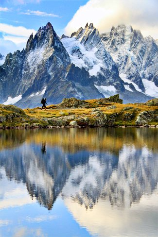
On leaving Chamonix we took a side route to Lac Blanc. Coloured milky lime, due to glacial silt, the lake offers one of the most picturesque settings from which to admire the French side of Mont Blanc.
Having spent the afternoon at the chalet waiting for the clouds to lift, we thought we’d be denied the view. But the next morning the clouds parted like a curtain to reveal the Chamonix Aiguilles, mirrored in the lake’s surface – a reminder of the magic that less perfect weather can offer in this spectacular region.
Source: Australian Geographic Outdoor, July/August 2012
Enter to win return flights to the European destination of your choice
RELATED STORIES


